January 13 , 2020 .
Philippines , Taal :
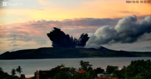
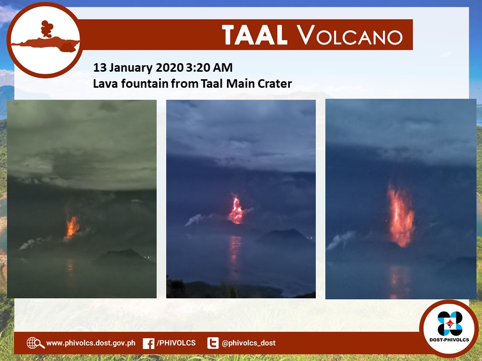
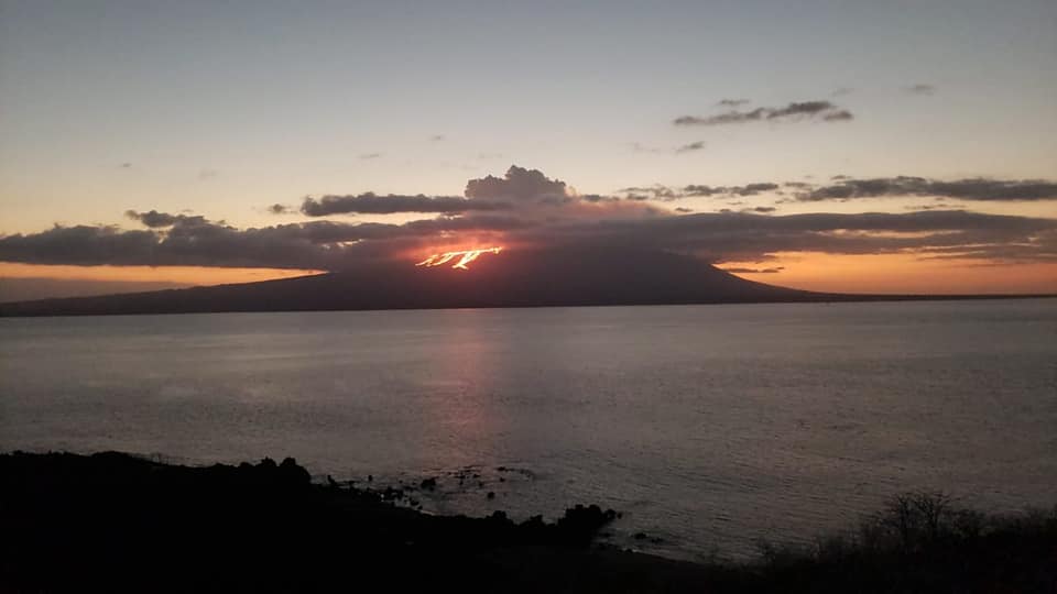
ERUPTION UPDATE FOR TAAL VOLCANO 13 JANUARY 2020 03:20
As of this issuance, ashfall from the ongoing eruption of Taal has reportedly fallen in the following areas: Tanauan, Batangas; Escala, Tagaytay; Sta. Rosa, Laguna; Dasmariñas, Bacoor, Silang, Cavite; Malolos, San Jose Del Monte, Meycauayan, Bulacan; Antipolo, Rizal; Muntinlupa, Las Piñas, Marikina, Parañaque, Pasig, Quezon City, Mandaluyong, San Juan, Manila; Makati City and Taguig City. Larger particles called lapilli measuring 2 to 64 millimeters in diameter have reportedly fallen in the following areas: Tanauan, Talisay, Batangas; Tagaytay City; Nuvali and Sta. Rosa, Laguna.

Fine ashfall can cause irritation and breathing problems especially among the elderly and children and it is particularly dangerous to our health. In addition, areas of ashfall have also experienced sulfurous smell which can also cause irritation. Affected populations are advised to protect their mouths and noses using N95 grade facemasks or wet cloth or towel. Motorists are advised to drive with extreme caution as ash can cause poor visibility and, when wet, can make roads slippery.
The Philippine Seismic Network has recorded a total of 52 volcanic earthquakes in the Taal region as of 12:49 AM, January 13, 2019. Twenty-six (26) of these earthquakes were felt with intensities ranging from Intensity II – V in Tagaytay City, Cabuyao, Laguna, Talisay, Alitagtag, Lemery and Bauan, Batangas. Such intense seismic activity probably signifies continuous magma intrusion beneath the Taal edifice, which may lead to further eruptive activity.
DOST-PHIVOLCS strongly reiterates the total evacuation of the Volcano Island and high-risk areas within the 14-kilometer radius from the Taal Main Crater. Areas in the general north are advised to guard against the effects of heavy and prolonged ashfall. Civil aviation authorities have advised aircraft to avoid airspace around Taal Volcano as airborne ash and ballistic fragments from the eruption column pose hazards to aircraft. DOST-PHIVOLCS is continually monitoring the eruption and will update all stakeholders of further developments.
TAAL VOLCANO BULLETIN 13 January 2020 8:00 A.M.
Taal Volcano entered a period of intense unrest beginning with phreatic or steam-driven activity in several points inside the Main Crater at 1:00 PM of 12 January 2020 that progressed into magmatic eruption at 02:49 AM to 04:28 AM of 13 January 2020. This magmatic eruption is characterized by weak lava fountaining accompanied by thunder and flashes of lightning. At 2:00 PM yesterday, booming sounds were heard at Talisay, Batangas.
The Philippine Seismic Network has recorded a total of seventy-five (75) volcanic earthquakes in Taal region as of 5:00 AM, January 13, 2020. Thirty-two (32) of these earthquakes were felt with intensities ranging from Intensity II – V in Tagaytay City, Cabuyao, Laguna, Talisay, Alitagtag, Lemery and Bauan, Batangas. Such intense seismic activity probably signifies continuous magmatic intrusion beneath the Taal edifice, which may lead to further eruptive activity.
Source : Phivolcs .
Photos : GMA News ( LJGregorio) , Desastres Al Momento , Phivolcs .
Ecuador / Galapagos , Fernandina :
Fernandina Volcano Special Report N ° 1 – 2020
New eruption on the Fernandina volcano
Summary :
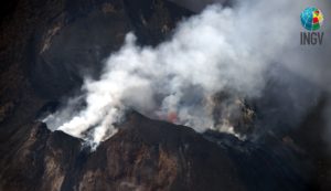
The Fernandina volcano, located in the province of Galapagos 90 km northwest of Puerto Villamil and 140 km northwest of Puerto Ayora, presented a new seismic agitation and a subsequent eruption today January 12, 2020, around 6:00 p.m. and 6:10 p.m. local time in the Galapagos (continental Ecuador time -1 hr). After the 4.7M magnitude seismic event occurred at 4:42 p.m., 29 localized events were recorded, the magnitude of which remained below M 3.1. The last eruption of this volcano occurred 19 months ago (June 16-18, 2018). Eruptive activity is located east of Fernandina Island along a circumferential fissure, as shown in Figures 1 and 2. IGEPN continues volcanic monitoring and will report if changes in activity are observed internal or external of the volcano.
History:
Fernandina (0.37 ° S, 91.55 ° W, 1476 m), also called Cerro la Cumbre, is a large shield volcano with a somital caldera (6.5 km North-West-South-East, 4.8 km North-East-South-West, 900 m deep), of basalt composition built by Fernandina Island (34 km North-West-South-East, 30 km North-East-South-West) at the West end of the Galapagos Archipelago.
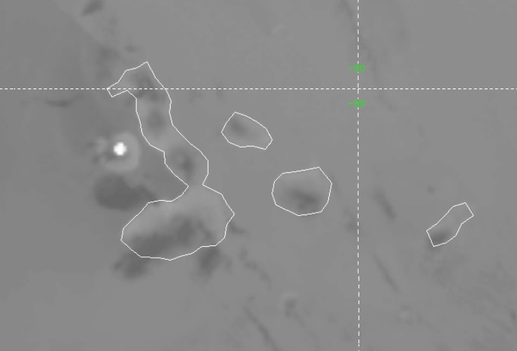
Figure 1. Location of the thermal alert associated with eruptive activity in the Fernandina volcano (source Imagery of volcanic clouds 12/01/2020).
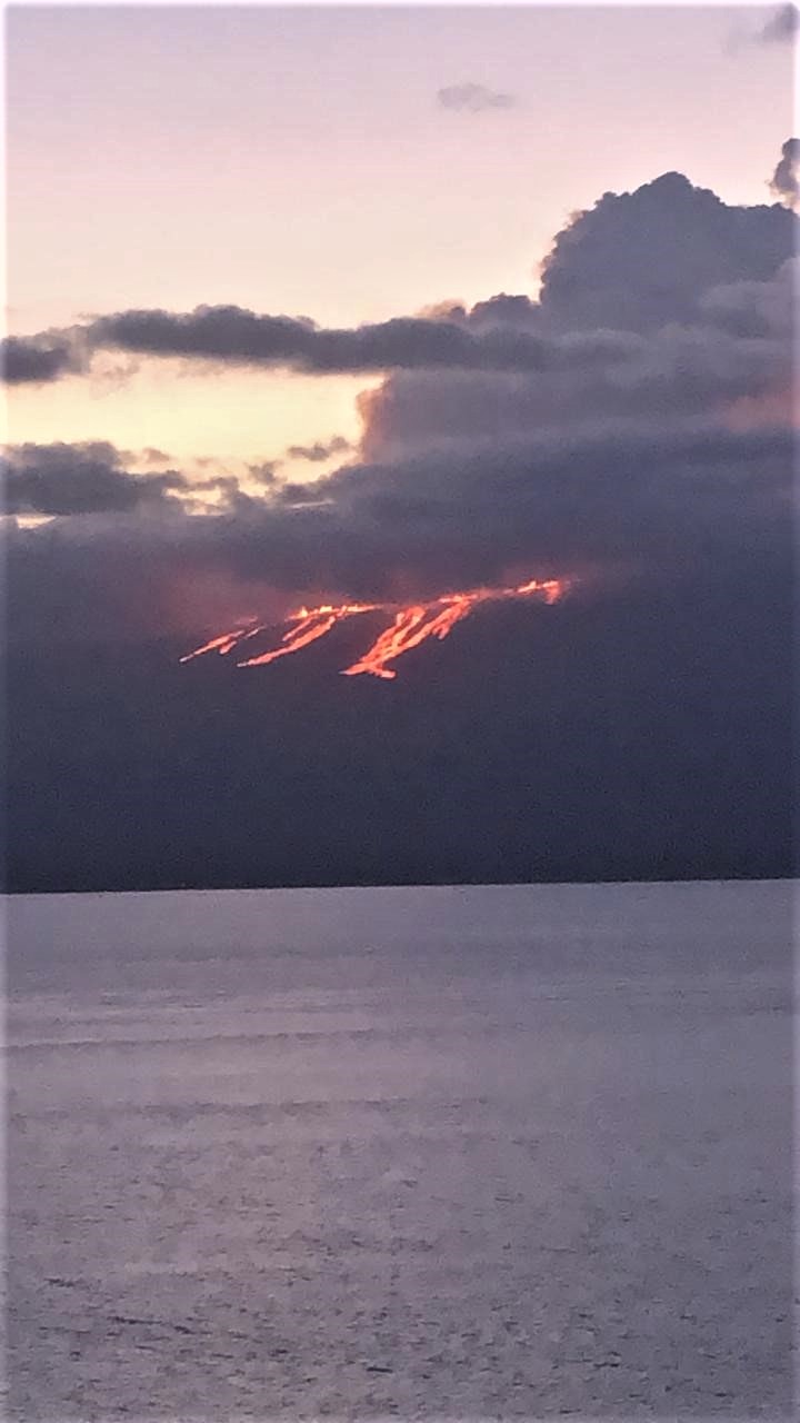
Figure 2. Lava flows observed in the Bolivar canal sector. Photo courtesy of Galapagos National Park.
Source : IGEPN ,Mfn / Institut géophysique / École nationale polytechnique .
Photos : parc national des Galapagos.
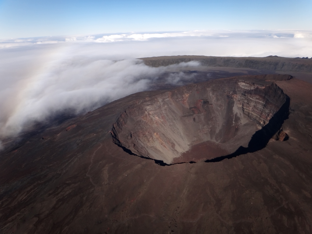
La Réunion , Piton de la Fournaise :
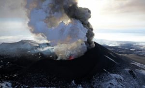
Activity bulletin for Monday 13 January at 6.45 a.m. (local time).
Alert level: Vigilance.
Following the short seismic crisis recorded on January 7 between 9:28 p.m. and 9:44 p.m. UT (i.e. between 1:28 a.m. and 1:44 a.m. local time on January 8), seismic activity continued under the Piton de la Fournaise (with respectively 8, 9 , 11 and 1 surface volcano-tectonic earthquake (s) recorded under the summit craters on January 8, 9, 10 and 11).
On January 12, between 6:17 p.m. and 6:24 p.m. UT (i.e. between 10:17 p.m. and 10:24 p.m. local time), a new seismic crisis was recorded under the summit area of Piton de la Fournaise with 41 superficial volcano-tectonic earthquakes. A total of 51 earthquakes were recorded during the day of January 12.
No rapid deformation of the soil surface was recorded during this crisis, which shows that the magma has not left the superficial magmatic reservoir.
This new seismic crisis shows that the superficial magmatic reservoir continues to pressurize as also shown by the continued inflation of the building.
Note that this pressurization process can last several days to several weeks before the tank roof weakens and breaks, thus giving rise to an injection of magma towards the surface and an eruption, and can also stop. without giving rise to an eruption in the short term.
Source : OVPF.
Read the article : http://www.ipgp.fr/fr/ovpf/bulletin-dactivite-lundi-13-janvier-a-6h45-heure-locale
Photo :Unknown author.
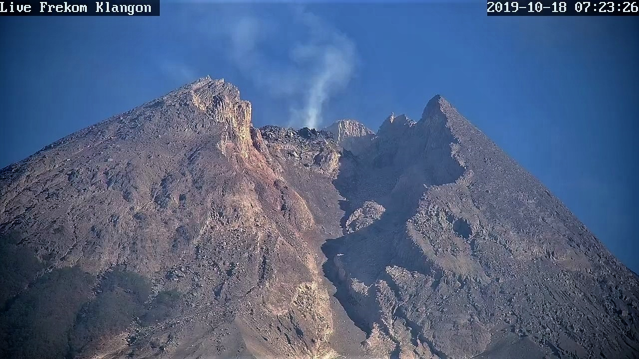
Indonesia , Merapi :
Activity report of the Merapi volcano from January 3 to 9, 2020
OBSERVATION RESULTS
visual:
The weather around Mount Merapi is generally mostly foggy and cloudy throughout the day, so smoke and fumarole morphology are not observed this week. The volume of the lava dome based on the analysis of aerial photos with the drone of November 19, 2019 amounted to 396,000 m3.
Earthquake:
In this week, the seismicity of Mount Merapi recorded:
1 hot avalanche cloud,
5 explosion earthquakes (DG),
21 deep volcanic earthquakes (VTA),
3 shallow volcanic earthquakes (VTB),
12 multi-phase earthquakes (MP),
9 avalanche earthquakes (RF),
1 low frequency earthquake (LF)
11 tectonic earthquakes (TT).
The VTA type seismicity this week is lower than last week.
Deformation:
The EDM distance in all areas cannot be measured because the weather is always foggy. Reference GPS Selo – Pasar Bubar ranged from 4,259.19 m to 4,259.20 m. The information from G. Merapi, who was monitored by GPS this week, showed no significant change.
Rain and lahars:
This week, there was rain at the Mount Merapi observation post with the highest precipitation of 26 mm / hour for 30 minutes at the Kaliurang post on January 8, 2020. There was no washing or runoff additional in the rivers that descend from Mount Merapi.
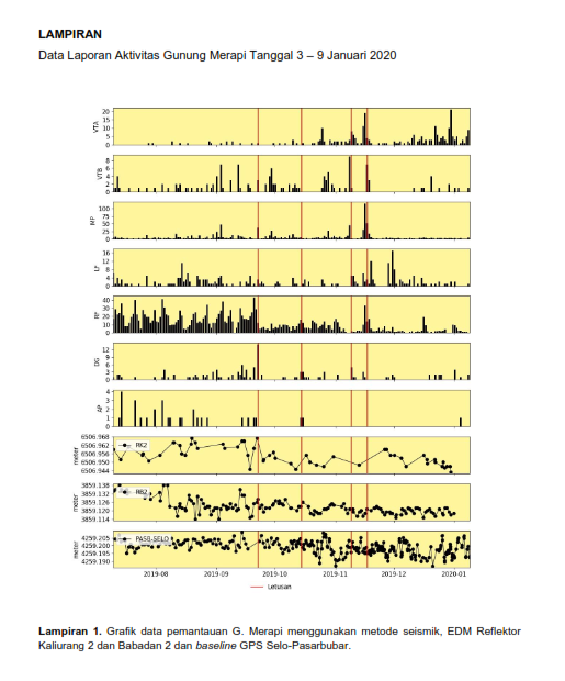
Conclusion:
Based on the results of the visual and instrumental observations, it was concluded that:
1. The lava dome is currently in a stable state
2. The volcanic activity of Mount Merapi is still quite high and is determined by the level of activity « WASPADA ».
3. The potential for danger today is in the form of a hot cloud caused by the collapse of the lava dome and an explosion of volcanic material from explosive eruptions.
Source : BPPTKG.
Photo : Live Frekom Klangon