December 18 , 2019.
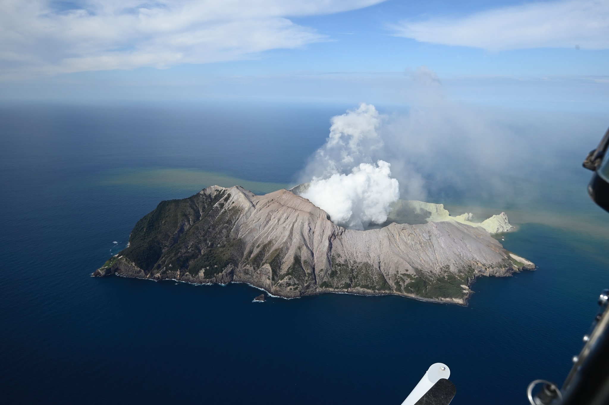
New Zealand , White Island :
Volcanic Alert BulletinWI – 2019/26 . Wed Dec 18 2019 12:00 PM; White Island Volcano
Volcanic Alert Level remains at 2
Aviation Colour Code remains at Orange
Volcanic tremor continues at a low level and no eruptions have occurred since Monday 9 December. Further eruptions are unlikely in the next 24 hours. The Volcanic Alert Level remains at Level 2.
Since the eruption on Monday 9 December, there have been only a few short episodes of minor ash emission close to the volcano. No further eruptive activity has occurred, and the level of volcanic tremor remains low.
The expert judgement made this morning calculated the likelihood of another eruption within the next 24 hours at 20 – 40 % which means another eruption is unlikely over the next 24 hours. Consequently, the distances for GNS Science staff-access zones have remained the same. This will be reviewed again tomorrow. During the past 24 hours, images from some cameras on the island have often been obscured by steam and weather clouds, and by muddy ash. However, this does not reduce our ability to monitor and interpret the status of the volcano.
An explosive eruption from the main vent area remains possible and could still occur with no precursory activity, especially if there is a collapse of unstable material around one of the vents, or if the gas emission decreases allowing groundwater to enter the vent.
Sudden steam/gas eruptions from other active vents are also possible.
Should any explosive activity produce an ash cloud there remains an extremely low likelihood of ash affecting the mainland in the next 24 hours. This ash would be a nuisance only, unless someone has a respiratory disorder. Check with your GP if you are concerned.
Rain washing appears to have cleared some ash off solar panels and monitoring equipment and solar power charging is already occurring. We are still receiving data from the remaining equipment, which allows us to continue monitoring the volcano. Both seismic stations on the island are fully operational and are providing us with round the clock data.
We will continue to provide 24-hour estimates of eruption likelihood to support operations.
GNS Science and our National Geohazards Monitoring Centre continue to closely monitor Whakaari/White Island for further signs of activity.
Source : Geonet / Michael Rosenberg / Duty Volcanologist
Photo : The Next California Earthquake
Colombia , Nevado del Ruiz :
Weekly newsletter of the Nevado del Ruiz volcano
The activity level continues at: yellow activity level or (III): changes in the behavior of volcanic activity.
Regarding the monitoring of the activity of the Nevado del Ruiz volcano, the COLOMBIAN GEOLOGICAL SERVICE reports that:
The Nevado del Ruiz volcano continues to show unstable behavior. In the past week, some of the parameters monitored have shown changes, reflecting this instability of the volcanic system, similar to that reported in recent weeks. The variations are mainly distinguished in seismicity, both associated with the movements of fluids inside volcanic conduits and with fracturing of rocks. It is not excluded that the monitored parameters continue to change, indicating an acceleration of the process and therefore changes in the level of activity of the volcano.
The seismicity linked to the dynamics of the fluids inside the volcanic conduits increased in number and decreased slightly in the energy of the recorded earthquakes, compared to the previous week. This type of seismicity presented significant variations in its spectral characteristics and was characterized by the presence of continuous volcanic tremors and earthquakes of the long period (LP) and very long period (VLP) type recorded individually or jointly with volcanic tremor pulses. The earthquakes presented varying levels of energy and were located mainly in the Arenas crater and its surroundings.
The seismicity caused by the fracturing of the rocks showed a decrease in the number of earthquakes and of the seismic energy released, compared to the previous week. This type of seismicity was mainly located in the northeast and southeast sectors of the volcanic structure and, to a lesser extent, in the Arenas crater and its surroundings. The depths of the earthquakes ranged from 0.5 to 8.5 km. The maximum magnitude recorded during the week was 0.6 ML (local magnitude), corresponding to the earthquakes recorded on December 13 and 14 at 03:52 and 19:27 (local time), located northwest of the Arenas crater at 3 , 5 and 3.7 km deep, respectively.

The deformation of the volcanic surface, measured from electronic inclinometers and GNSS (Global Navigation Satellite System) stations, did not show any significant change during the week.
As part of the follow-up of information provided on the MIROVA and NASA FIRMS web portals, low energy thermal anomalies were recorded on December 10 and 13.
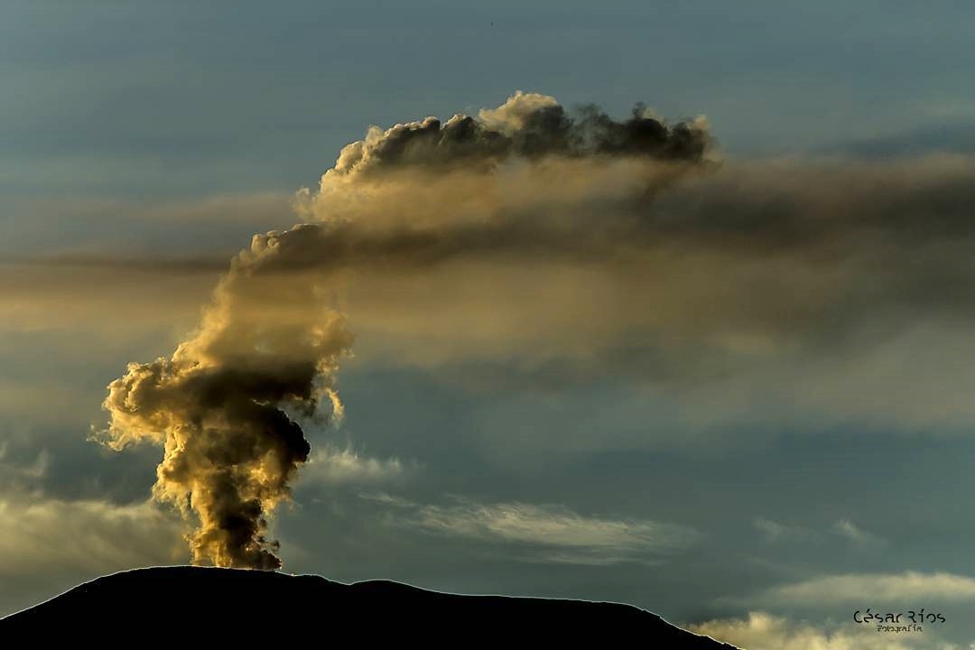
The gas and vapor column reached a maximum height, on December 16, of 1890 m measured at the top of the volcano.
The Nevado del Ruiz volcano continues at the level of yellow activity.
Source : SGC.
Photos : Cesar Rios , SGC.
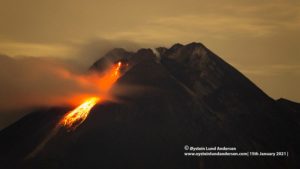
Indonesia , Ibu :
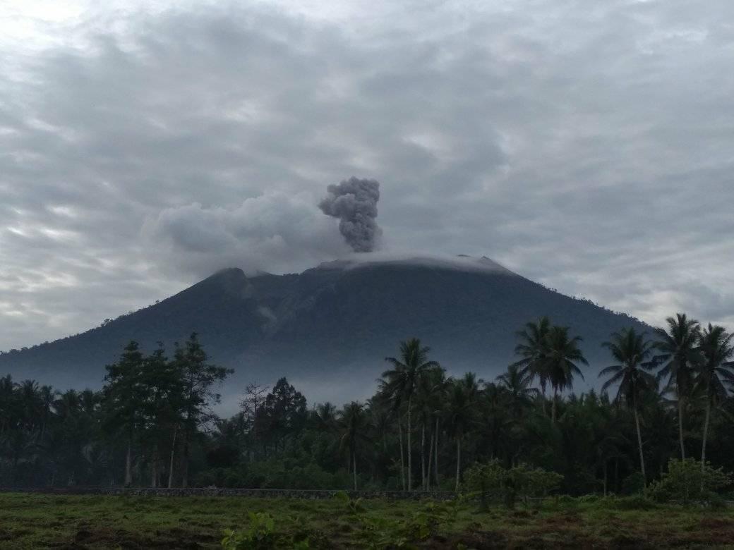
Level of activity at level II (WASPADA). G. Ibu (1,340 m above sea level) has experienced a continuous eruption since 2008
The volcano is clearly visible until it is covered with fog. White-gray smoke is observed, of fine to thick intensity, of low to moderate pressure and from 200 to 800 m altitude above the summit. The weather is sunny, cloudy to rainy, the wind blows weakly towards the South and West.
https://www.facebook.com/toguualamo/videos/2743331485687140/
According to the seismographs of December 17, 2019, it was recorded:
70 eruption earthquakes.
7 explosion earthquakes
44 avalanche earthquakes
19 harmonic tremors
1 deep volcanic earthquake.
8 distant tectonic tremors.
Recommendation:
The community around G. Ibu and visitors / tourists must not move, climb and approach within a radius of 2 km, with a sectoral expansion of 3.5 km until the opening in the northern part of the active crater of G. Ibu.
VONA:
The last VONA was sent with the color code ORANGE, published on December 3, 2019 at 10:31 WIT, linked to an eruption with a height of the ash column at about 2125 m above sea level or about 800 m above the summit . The ash column was moving north.
Source : PVMBG.
Photo et vidéo : Alex Djangu Trekker.
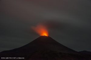
Alaska , Shishaldin :
54°45’19 » N 163°58’16 » W,
Summit Elevation 9373 ft (2857 m)
Current Volcano Alert Level: WATCH
Current Aviation Color Code: ORANGE
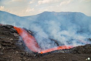
Seismicity remains elevated at Shishaldin Volcano consistent with low-level eruption. Elevated surface temperatures were observed in cloudy satellite data showing a 2 km (1.2 mile) lava flow on the northwest flank. Web camera views were obscured by snow on the lens over the past 24 hours.
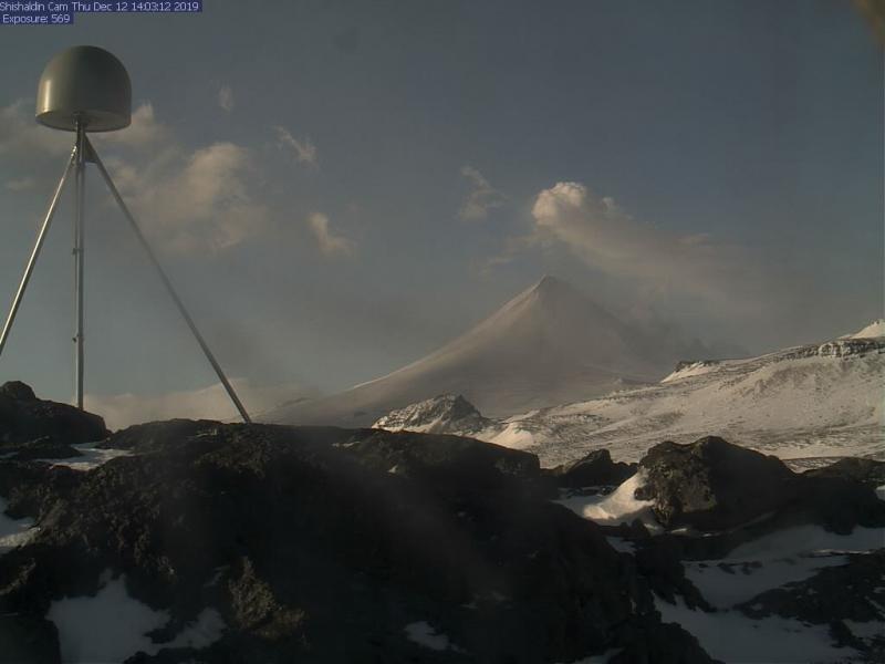
Episodic explosions and lava flow front collapses resulting in low-level ash plumes can occur with little warning.
Shishaldin is monitored by local seismic and infrasound sensors, satellite data, web cameras, a telemetered geodetic network, and distant infrasound and lightning networks.
Source : AVO.