December 01 , 2019.
Costa Rica , Rincon de la Vieja / Poas / Turrialba :
Rincon de la Vieja Volcano .
Volcanic chain of Guanacaste.
10,831 ° N – 85,336 ° W
Altitude of the active crater: 1560 m.s..m.

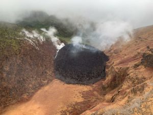
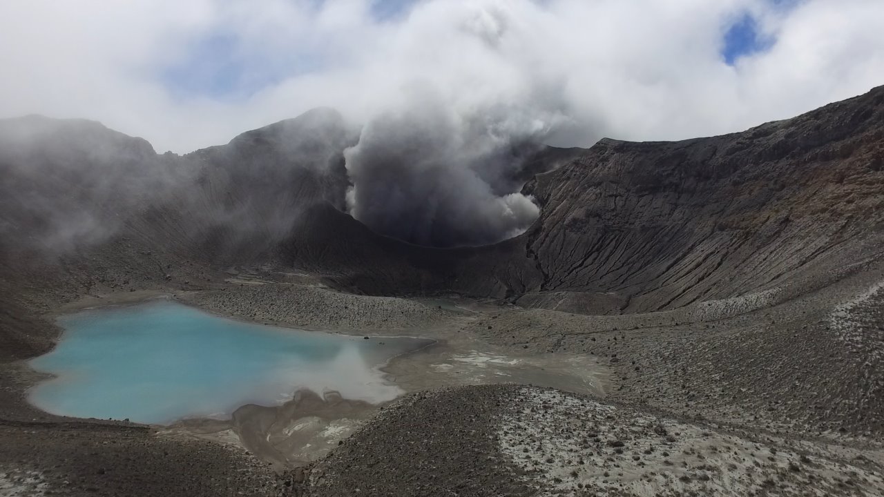
On this photograph of Rincon de la Vieja volcano, dated 19 November 2019, taken from the southern flank of the crater, a greenish-grayish tone is observed in the acidic lake with the GNSS precision GPS antenna for monitoring active cracks. on the southern flank of the crater.
The seismic activity was maintained with the appearance of long-period type signals (about two tens) and two volcano-tectonic type signals, both types of signals recorded at the stations closest to the volcano. Spasmodic tremor decreased in amplitude from October 31 and continues to this day.
On 19 November, the installation of a GNSS precision GPS device to monitor the cracks on the southern flank of Active Crater was completed.
With the collaboration of Francisco Muñoz from OVSICORI, thermal photographs were taken of fumaroles located in the western sector of the active crater and the acidic lagoon. The maximum relative temperature recorded in the fumarole zone was 93 ° C while in the lagoon it was 32 ° C.
It is recommended to stay away from the canals of rivers near the volcano in case of eruption, because of the possibility of generating primary lahars. In addition, rains, ashes and accumulated materials in the upper parts of the volcano could generate secondary lahars.
Poas Volcano.
Central volcanic chain
10.197 ° N – 84.702 ° W
Altitude of the active crater: 2550 m.s..m.
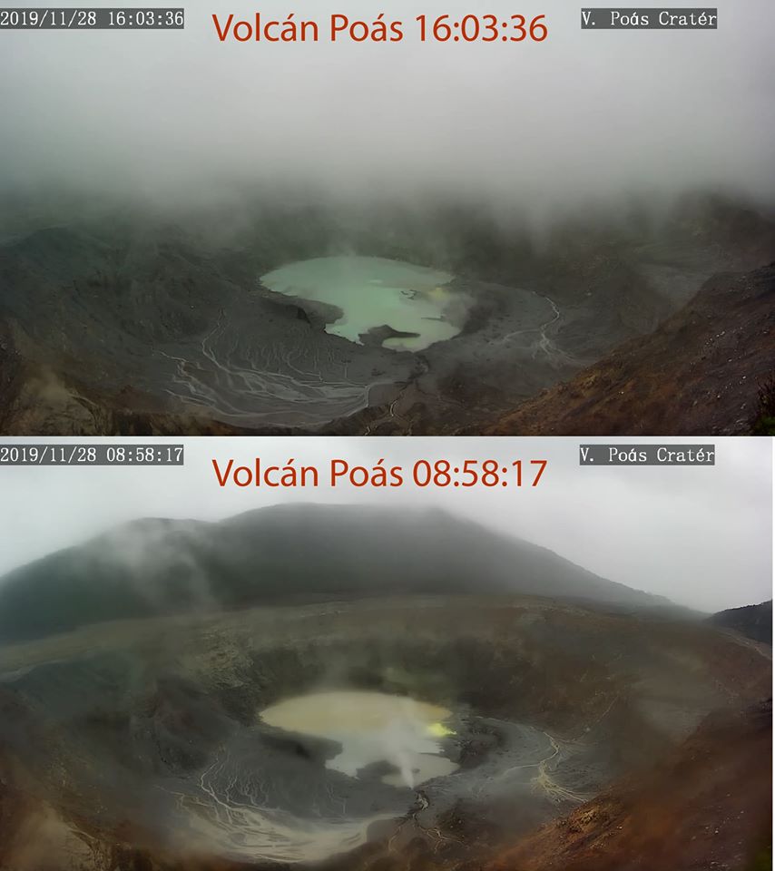
Photographs of volcano Poás taken with the volcanic surveillance camera of the RSN on November 28th.
The photo below was taken in the morning while it was raining heavily. The brown lagoon is observed due to the entry of sediments carried by the water. In the photo above, taken in the afternoon, the lake had already returned to its greenish color.
Dr. Paulo Ruiz
The lake maintained its surface area compared to the previous week. The color of the water tends to be greenish. The evaporation processes were a little more intense than the previous week and rainfall decreased. The field of fumaroles rich in sulfur in the North-East sector maintains its activity of expiration. From the mouth A, an output of projections and gases has been observed. Seismically, the background tremor of low amplitude (2 to 4.5 Hz) was maintained, as well as discrete events of type LP (long period) of low amplitude. Visitors to the Poás Volcano National Park are reminded that this site has protocols for eruptions. Depending on the type of activity, visits may be suspended or delayed.
Turrialba Volcano.
Central volcanic chain
10,017 ° N – 83,765 ° W
Altitude of the active crater: 3230 m.s..m.
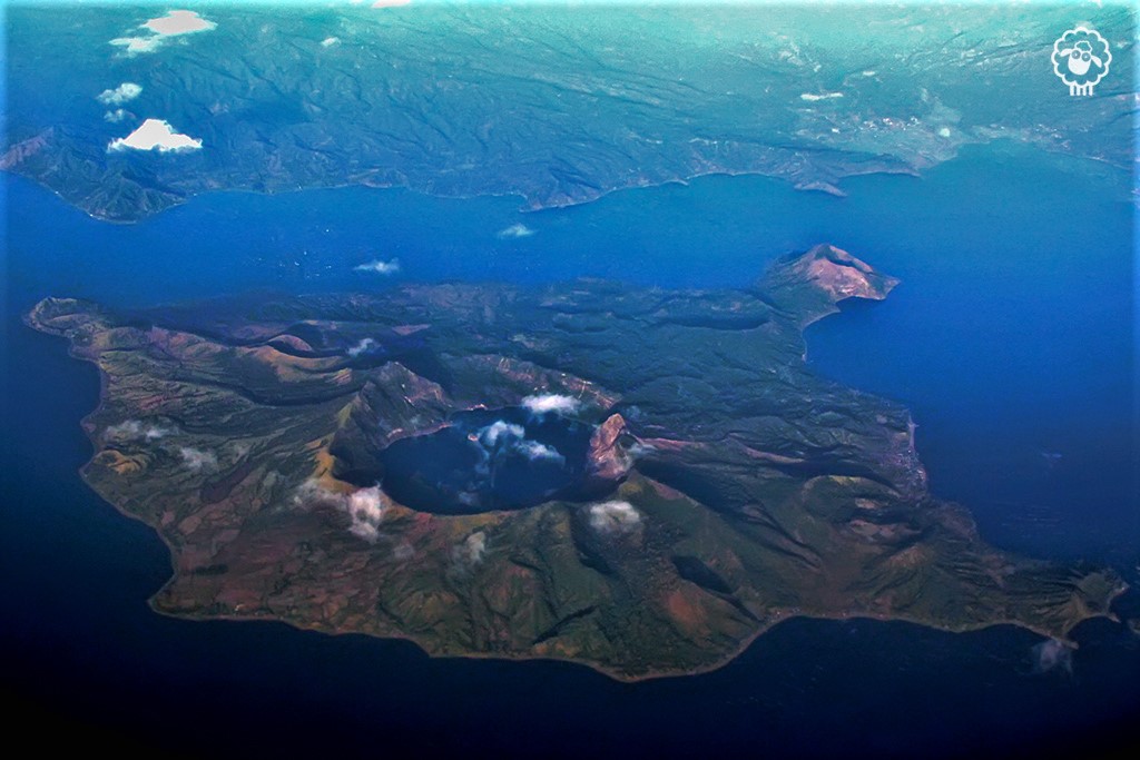
This photograph of the volcano turrialba was captured by members of the national seismological network on February 9, 2018 in the massif. A turquoise green color is observed in one of the lagoons.
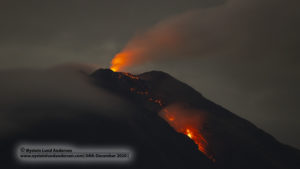
The Turrialba volcano showed a stable and weak state of activity. The column of water vapor and gas dispersed mainly to the western and southwestern sectors, with the exception of the early morning or it is dispersed towards the North-West sector. The seismic activity is little dominated by discrete low frequency earthquakes. The presence of two lakes at the top of the volcano continues, with variations depending on the rain, while a third body of water forms a few hours after the rains, then disappears. The incandescence recorded by the volcanic surveillance cameras in the active crater remains as intense as the previous week. No major changes in seismicity were reported compared to the previous week. The public is reminded that the entrance to the Turrialba Volcano National Park, which coincides with a radius of 2 km around the active crater, is closed due to the activity of the volcano. Approaching the crater means a very high risk activity.
Source : RSN Costa Rica .
Photos : José Ana González/ ice , RSN , Dr. Paulo Ruiz , Dr. Guillaume Alvarado Et Blas Sanchez (CNE).
Philippines , Taal :
This is to notify the public and concerned authorities on the current activity of Taal Volcano.
Since raising the alert level of Taal Volcano to Alert Level 1 last March 28, 2019, the Taal Volcano seismic network has recorded 4857 volcanic earthquakes as of today (December 1, 2019). Some of these earthquakes were felt with intensity ranging from Intensity I (Scarcely Perceptible) to Intensity III (Weak Shaking) in Brgy. Banyaga, Agoncillo; Brgy. Calauit, Balete; Sitio Tibag, Brgy. Pira-Piraso, Sitio Tuuran, Brgy. Tabla, and Brgy. Buco, Talisay; and Brgy. Alas-as and Brgy. Pulangbato, San Nicolas, Batangas. Often, these felt earthquakes were accompanied by rumbling sounds. Precise leveling (PL) measurements on Taal Volcano Island from November 21 – 29, 2019 showed further inflation of the volcano edifice, consistent with the recent results from continuous GPS data. An increase in Carbon Dioxide (CO2) emission is also observed inside the Main Crater starting around April of 2019. However, there are no significant changes in the water temperature and acidity of the Main Crater Lake.
Alert Level 1 remains in effect over Taal Volcano. This means that hazardous eruption is not imminent. However, there is a possibility of magmatic disturbance ongoing under the volcano. In the event of further increase in number of volcanic earthquakes, higher concentration of gases, continuous inflation of the volcano’s edifice, increase in water temperature and/or occurrence of widespread bubbling at the lake of the Main Crater, Taal Volcano’s status will be raised to Alert Level 2.
DOST-PHIVOLCS strongly recommends vigilance and readiness of communities in the Volcano Island especially with the projected track of Typhoon Tisoy in CALABARZON based on the Severe Weather Bulletin #3 issued by PAGASA at 5AM on December 1, 2019. DOST-PHIVOLCS also reminds the public that the Main Crater is strictly off-limits because sudden steam explosions may happen and high concentrations of toxic gases may accumulate. The northern portion of the Main Crater rim, near the Daang Kastila Trail, may also become hazardous when steam emission along existing fissures abruptly increases. DOST-PHIVOLCS strongly emphasizes that the entire Volcano Island is a Permanent Danger Zone (PDZ) and is not recommended for permanent settlement at all times.
DOST-PHIVOLCS is closely monitoring Taal Volcano’s condition and any new development will be relayed to all concerned.
Source : Phivolcs.
Photo : Talisay, Batangas.
Chile, Nevados of Chillan :
Special Volcanic Activity Report (REAV), region of the Nevados de Chillán volcanic complex, on November 30, 2019 at 6:15 am local time (mainland Chile).
The National Geological and Mining Service of Chile (Sernageomin) discloses the following PRELIMINARY information obtained from the monitoring equipment of the National Volcanic Monitoring Network (NVRN) processed and analyzed at the Volcanological Observatory of the South Andes (OVDAS) ):
On Saturday, November 30 at 05:53 local time (08:53 UTC), monitoring stations near the Nevados de Chillán volcanic complex recorded an explosion associated with an LP-type seismic signal.
The characteristics of the LP earthquake are as follows:
TIME OF ORIGIN: 05 h 53 local time (08 h 53 UTC)
LATITUDE: 36,871 ° S
LONGITUDE: 71,377 ° W
DEPTH: 0.6 km
REDUCED TRAVEL: 650 cm2
ACOUSTIC SIGNAL: 1.6 Pascals (Pa) reduced to 1 km
OBSERVATIONS:
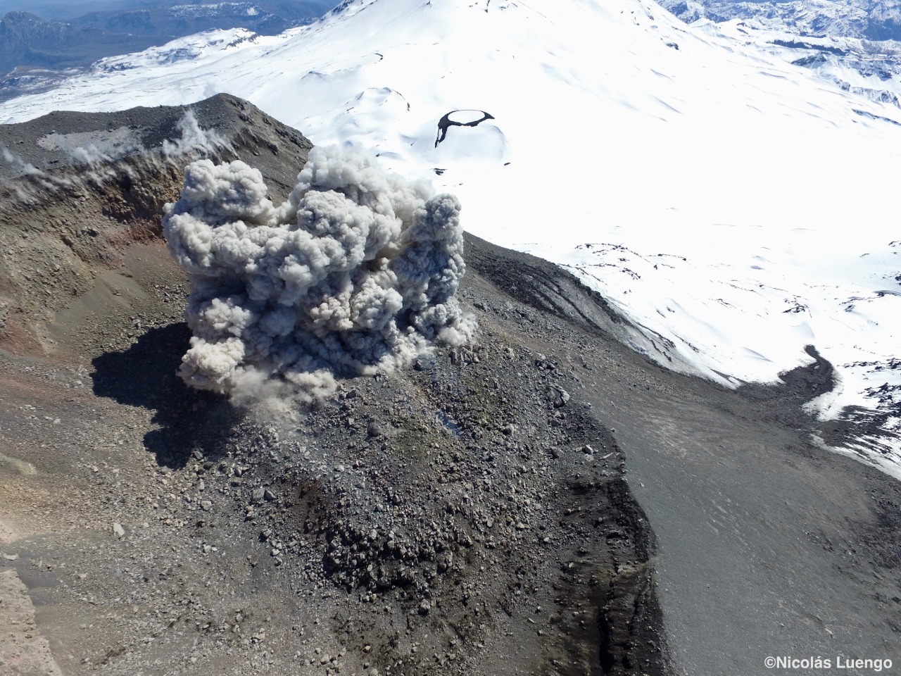
The gas column associated with the explosion was approximately 0.7 km high, above the crater.
The volcanic technical alert is maintained at the ORANGE level.
Sernageomin monitors online and informs in a timely manner of possible changes in volcanic activity.
Source : Sernageomin .
Photo : Nicolas Luengo
Mexico , Colima :
VAAC: WASHINGTON . 30 Novembre 2019
VOLCANO: COLIMA 341040
AREA: MEXICO
SUMMIT ELEV: 12631 FT (3850 M)
ADVISORY NR: 2019/002

INFO SOURCE: GOES-EAST. 557TH WW. WEB CAM. NWP
MODELS. VOLCAT.
ERUPTION DETAILS: Eruption with ash émission
REMARK: WE HAVE RECEIVED INFORMATION SUGGESTING A
POSSIBLE VA EMISSION. WE WILL GATHER FURTHER
INFORMATION AND ISSUE A FULL ADVISORY AS SOON AS
POSSIBLE.
Source : Vaac Washington.
Guatemala , Santiaguito :
Volcano Special Bulletin. November 29, 2019, 11:18 am local time
Activity type: Pelean
Morphology: Complex of dacitic domes
Geographical location: 14 ° 44 ’33 ˝ Latitude N; 91 ° 34’13˝ longitude O
Height: 2500msnm.
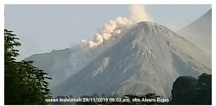
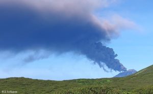
Photo 1. Heavy avalanches in the southwesterly direction raise ashes in the wake of the wind.
Over the past few hours, OVSAN and seismic activity have recorded moderate to heavy avalanches, with a pathway to the base of the volcano, which is responsible for resuspending ashes going back up the Southwest flank. The ashes reach an approximate height of 3,500 meters above sea level (11,483 feet) and have traveled 20 km to the South-South-West.
As a result of this activity, ashes fall in San Marcos Palajunoj, in the village of Loma Linda and on farms on the southwest flank. Similar events may continue to occur in the coming hours and the possibility of pyroclastic flows is not excluded.
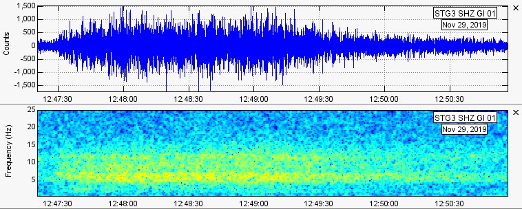
Graph 1. Seismogram related to the event shown in the picture 1.
Therefore, INSIVUMEH recommends:
For the SE-CONRED: to be aware of the evolution of the activity of the Santiaguito volcano, taking into account the avalanches.
AT THE DIRECTION GENERALE DE L’AERONAUTIQUE CIVILE: Take precautions for air traffic, this activity may generate ash in the vicinity of the volcano at an approximate height of 11483 feet and travel a distance of 20 km to the southwest .
Source : Mis à jour par Fredy Arnoldo Esquit Chiquita / Insivumeh.