January 21 , 2019.
Indonesia , Merapi :
MERAPI ACTIVITY REPORT, 11-17 January 2019
I. RESULTS OF OBSERVATION
Visual:
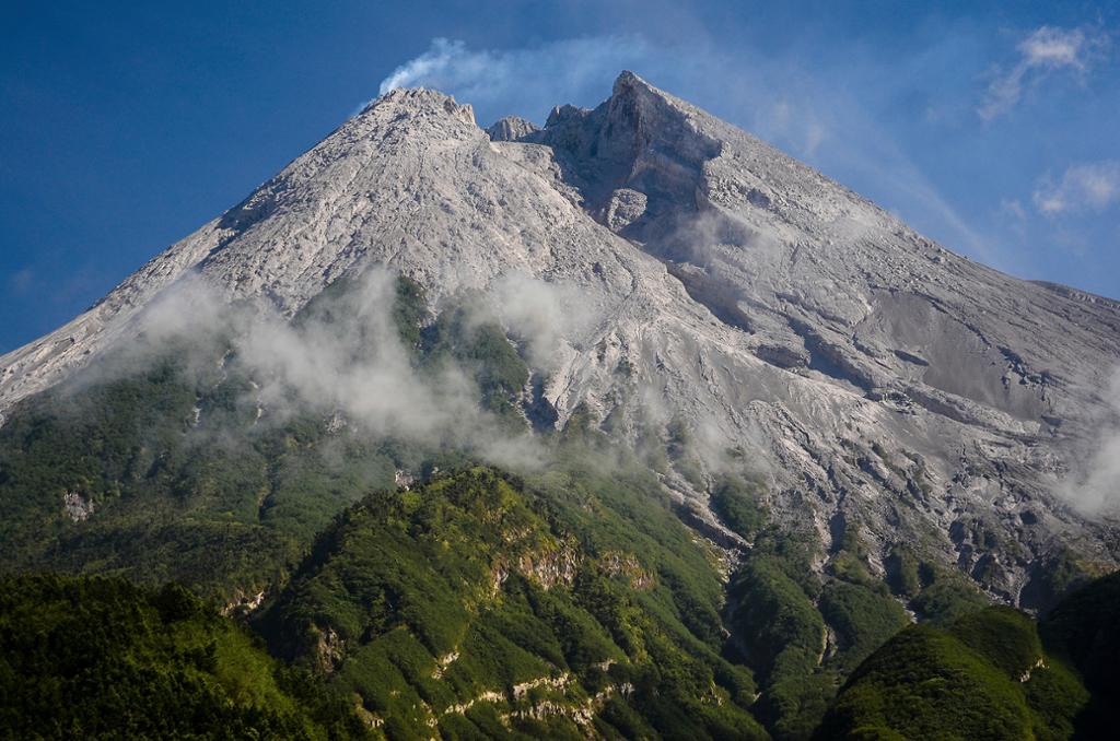
The weather is sunny in the morning and the afternoon and evening misty. The observed smoke, coming from the crater, is white, thin, with a low gas pressure. The maximum height of 150 m was observed from the observation post of Merapi Babadan on January 11, 2019.
Dome of lava and morphology of the peak:
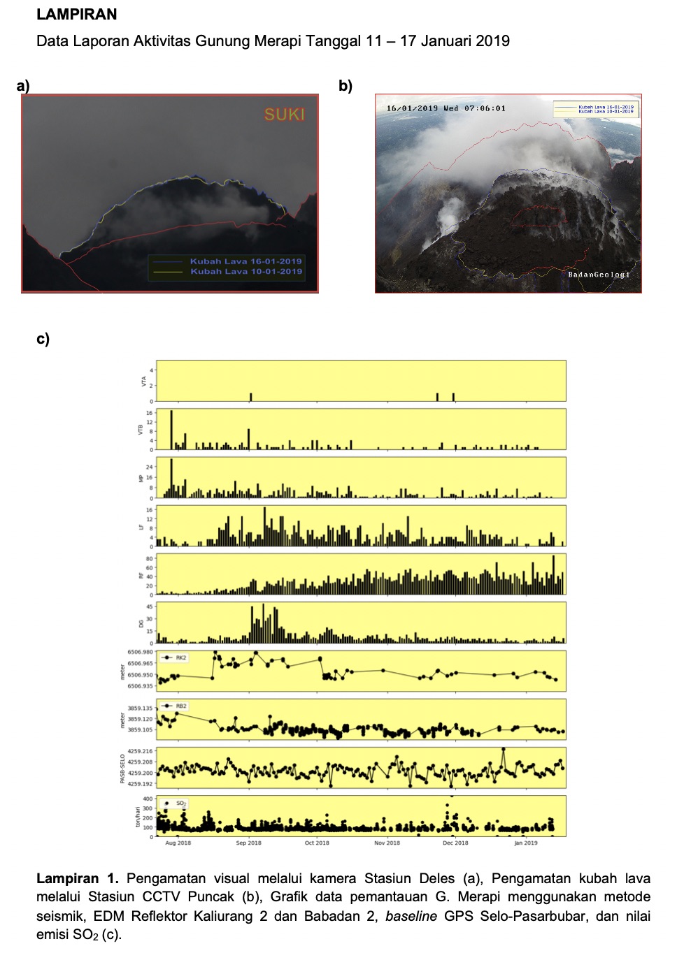
Morphological analysis based on photos of the Southeast sector showed morphological changes in the form of dome growth. Annex 1.a presents morphological analysis of the peak via the Deles camera station.
The volume of the lava dome on January 16, 2019 was 453,000 m3 with an average growth rate of 2,300 m3 / day, lower than the previous week. Currently, the lava dome is still stable with a low growth rate (<20,000 m3 / day). Appendix 1.b presents an analysis of the lava dome from the Puncak camera stations.
Seismicity:
During this week, the seismicity of Mount Merapi recorded 25 emission earthquakes (DGs), 1 shallow volcanic earthquake (VTB), 314 avalanche events (RF), 13 low-frequency earthquakes (LF) and 3 tectonic earthquakes (TT). DG and RF seismicity is higher this week than the previous week.
Deformation:
The deformation of the Merapi, monitored by EDM and GPS this week, showed no significant change.
SO2 emissions:
During this week, the DOAS (Differential Optical Absorption Spectroscopy) measurement yielded an average peak SO2 emission value of Mount Merapi at 92.68 tonnes / day, still within normal limits.
Rain and lahars:
This week, it was raining at the Mount Merapi observation post on January 15, 2019, with a rain intensity of 38 mm / hour for 80 minutes. It was reported that there was an increase in flow in the Apu River on January 15, 2019 and in the Gendol River on January 17, 2019 due to rain in the Mount Merapi summit region.
II. CONCLUSION AND ADVICE
Conclusion:
Based on the results of the visual and instrumental observations, it was concluded that:
1. The lava dome is currently in a stable state with a relatively low growth rate.
2. The volcanic activity of Mount Merapi is still quite high and is at the activity level « WASPADA ».
Suggestion:
With the level of activity of Mount Merapi to « WASPADA » is recommended as follows to stakeholders in disaster management around Mount Merapi:
• A radius of 3 km around the summit of Mount Merapi must be prohibited for the activities of the population and climbing.
• If there is a significant change in activity, the activity status of Mount Merapi will be re-examined.
• When it comes to the rainy season, people who move around the rivers below Mount Merapi are aware of the danger of lahars.
• It is recommended that local authorities socialize the current state of Merapi activity.
Source : a.n. Chef du centre de volcanologie et d’atténuation , BPPTKG.
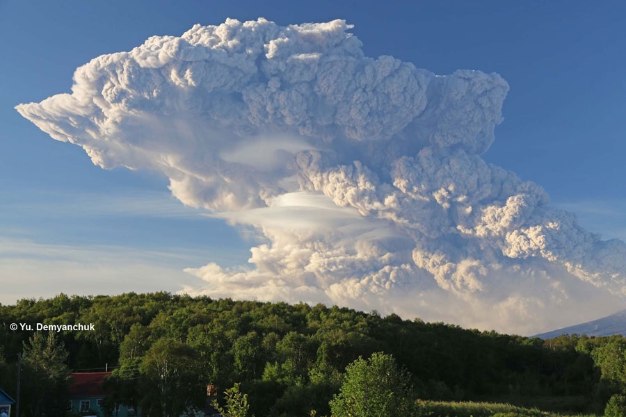
Photo : Azimuth Adventure Travel
Kamchatka , Bezymianny :
VOLCANO OBSERVATORY NOTICE FOR AVIATION (VONA).
Issued: January 20 , 2019
Volcano:Bezymianny (CAVW #300250)
Current aviation colour code: RED
Previous aviation colour code:orange
Source:KVERT
Notice Number:2019-21
Volcano Location:N 55 deg 58 min E 160 deg 35 min
Area:Kamchatka, Russia
Summit Elevation:9452.96 ft (2882 m)
Volcanic Activity Summary:
A strong explosive eruption of Bezymianny occurred at 16:10 UTC on 20 January: explosions sent ash up to 10 km a.s.l., and ash cloud began to drift to the north-west from the volcano. Activity of Bezymianny continues: a strong gas-steam plume with some amount of ash on the height about 3.5-4.5 km a.s.l. continues to drift to the north-west from the volcano; but an ash cloud from the strong explosions continues to drift on the height about 10-11 km a.s.l. on the distance about 600 km to the north-west from the volcano. Ongoing activity could affect international and low-flying aircrafts.
A moderate eruptive activity of the volcano continues. Ash explosions up to 32,800 ft (10 km) a.s.l. could occur at any time. Ongoing activity could affect international and low-flying aircrafts.
Volcanic cloud height:
11480-14760 ft (3500-4500 m) AMSL Time and method of ash plume/cloud height determination: 20190120/2230Z – Video data
Other volcanic cloud information:
Distance of ash plume/cloud of the volcano: 367 mi (590 km)
Direction of drift of ash plume/cloud of the volcano: WNW / azimuth 294 deg
Time and method of ash plume/cloud determination: 20190120/2129Z – NOAA 18 (4m5)
Source : Kvert.
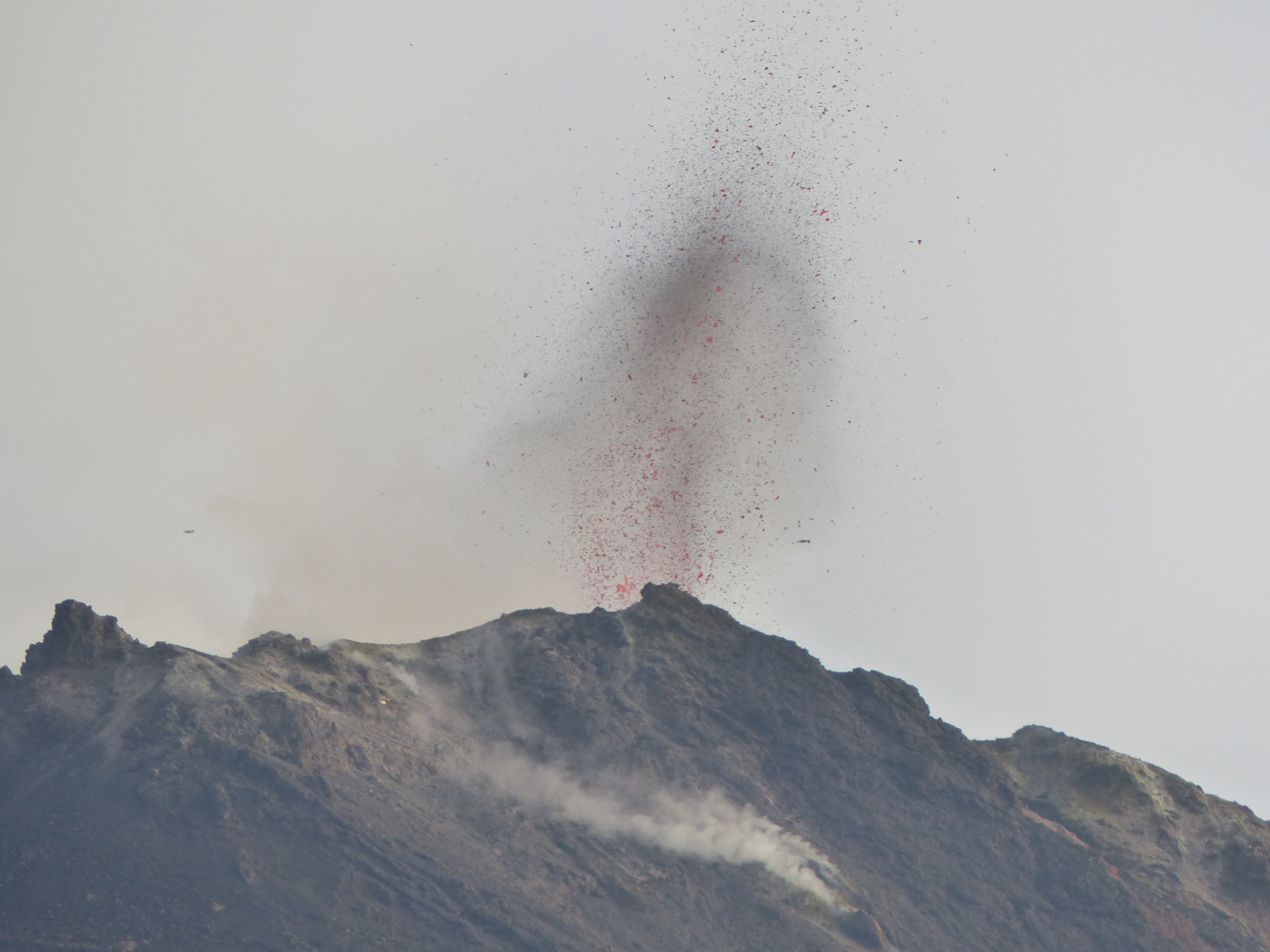
Photo : Yu. Demyanchuk, IVS FED RAS , 1/9/2012 .
Costa Rica , Rincon de la Vieja :
Daily report of the state of the volcano. OVSICORI-UNA, Date: 2019-01-20
Updated at: 10:07:00.
Rincón de la Vieja Volcano:
On January 20, 2019, at 1:26 am local time, there is an eruption on the Rincon de la Vieja volcano. The height reached by the column is unknown because of the visibility conditions of the site.
Duration of the activity: 5 minutes.
The seismic activity is similar to that of yesterday.
The wind direction is unknown at the moment.
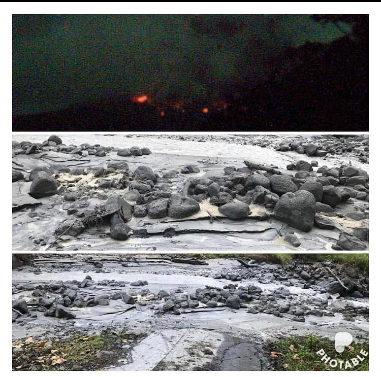
January 20, 2019
Top image: Incandescent material observed at the top of the Rincon de la Vieja volcano, seen from Sensoria via the OVSICORI webcam. Bottom images: Debris caused by the current of Azufrado River. Images provided by Oscar Alvarado « Mapache ».
The most intense phase of the 1:26 eruption lasted 5 minutes depending on the seismic signals. The web camera located in Gavilán de Upala recorded the fall of incandescent blocks. Lahar are reported in Río Pénjamo, Río Azúl and Azufrada. From June 20 to the end of 2018, the Rincón has presented at least 2 to 5 monthly eruptions. In January, its activity intensified with 7 eruptions, those of this month being the strongest: the 17th of this month at 1:28. and today also at dawn at 01:26
The population must be vigilant because many eruptions occur at dawn with few warning signals, allowing them to prevent mud flow (lahars) through rivers and even pyroclastic flows.
Source: Javier Pacheco OVSICORI, Henriette Bakkar, RSN-OSIVAM et Guillermo Alvarado, RSN-CNE.
Photo : Oscar Alvarado « Mapache ».
Italie , Stromboli :
Transcription of the January 2 article of Volcanodiscovery.
The activity of the volcano remains elevated – magma is still standing high inside its conduits.
When observed from close earlier today, there were 6 active vents producing intermittent strombolian explosions of small to large size:
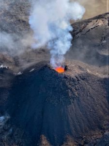
The new cinder cone that has been built recently around the NE vent displayed mild and continuous lava spattering with intense lava glow at night, as well as strombolian explosions of small to moderate size (ejection heights racing from few tens of meters to approx. 150 m) at intervals of 10-20 minutes.
The strongest explosions, however occurred from both the easternmost vent (below the more active NE cone, ) as well as (and more frequently) from the westernmost vent, both ejecting incandescent material to certainly more than 200 m height and bombs reaching much of the crater terrace and its surroundings. Intervals of explosions were about one every 10-15 minutes vor the western vent and more rarely from the easternmost one (once per 30-40 minutes). As has been typical for the past decades, the westernmost vent usually generated significant amounts of ashes, while all other vents had almost no ash during their explosions.
Some of the most notable eruptions, however, occurred from a vent in the NW area of the crater area: it forms a steep-sided, symmetric, conical shaped small cone and frequently erupted dense, candle-like lava fountains, as well as sometimes only mostly gas jets. Its eruptions were often accompanied by very loud detonation sounds. Occasionally, this vent also produced beautiful « smoke rings » (ring vortexes), apparently caused by pulsating gas emissions from its circular vent.
A small vent just east of the mentioned westernmost vent also erupted in similar, but weaker style (narrow jets of lava) occasionally. Last, the formerly called « central crater », in the southern central part of the crate terrace also had infrequent, typically small to moderately-sized classic strombolian eruptions. In the past this vent often displayed constant glow and spattering, but did not do so today.
All in all, explosions occurred at intervals of about 2-3 minutes from all 6 vents combined.
Source : Volcanodiscovery . ( www.volcanodiscovery.com )
Voir l’article et les vidéos : https://www.volcanodiscovery.com/stromboli/news/73823/Stromboli-volcano-Italy-frequent-and-strong-explosions-from-6-vents-observation-report-from-close.html?fbclid=IwAR2ThWOfh3oCxqEBpcyXHrtzMVU3nDi1r_fjH3_VLJtTXRBdZeO-A1561CY
Photo : Georges Vitton.