January 17 , 2019.
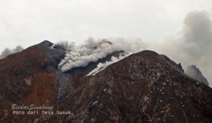
Colombie , Nevado del Ruiz :
Weekly activity bulletin of the Nevado del Ruiz volcano
The level of activity continues at the level: Yellow activity level or (III): changes in the behavior of volcanic activity.
With regard to monitoring the activity of the Nevado del Ruiz volcano, the COLOMBIAN GEOLOGICAL SERVICE announces that:
During the last week, seismicity caused by rock fracturing showed similar levels of earthquake numbers and a slight decrease in released seismic energy compared to the previous week. The earthquakes were located mainly in the Arenas crater and in the South-South-East and North-East areas of the volcano, at depths between 0.4 and 6.2 km. The highest-energy earthquake was recorded on 8 January at 03:53 (local time), had a magnitude of 0.9 ML (local magnitude), and was 0.9 km southeast of Arenas Crater at 3, 3 km deep.
Seismicity related to fluid dynamics within the volcanic structure ducts also showed similar levels with respect to the number of earthquakes and an increase in released seismic energy compared to the previous week. This seismic activity was characterized by the presence of earthquakes of long periods, very long periods and pulsations of volcanic tremors. The earthquakes occurred mainly in the crater Arenas and its surroundings.
Volcanic deformation measured from electronic inclinometers showed stability during the week. GNSS (Global Navigation Satellite System) stations and radar images continue to display stability behavior without recording significant deformation processes of the volcanic structure.
The volcano continues to emit water vapor and gases into the atmosphere, among which sulfur dioxide (SO2) is distinguished, as evidenced by the values obtained by the SCANDOAS stations installed in the region of the volcano. satellite image analysis. During the week, the NASA FIRMS and MIROVA portals reported several low-energy thermal anomalies.
The column of gas and steam reached a maximum height of 1900 m, measured at the top of the volcano on January 8th. The direction of column dispersion was governed by the direction of the wind in the area, which predominated to the southeast and northeast of the volcano.
The Nevado del Ruiz volcano continues at the level of yellow activity.
Source : SGC.
Photo : Bigthink
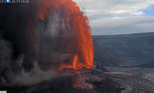
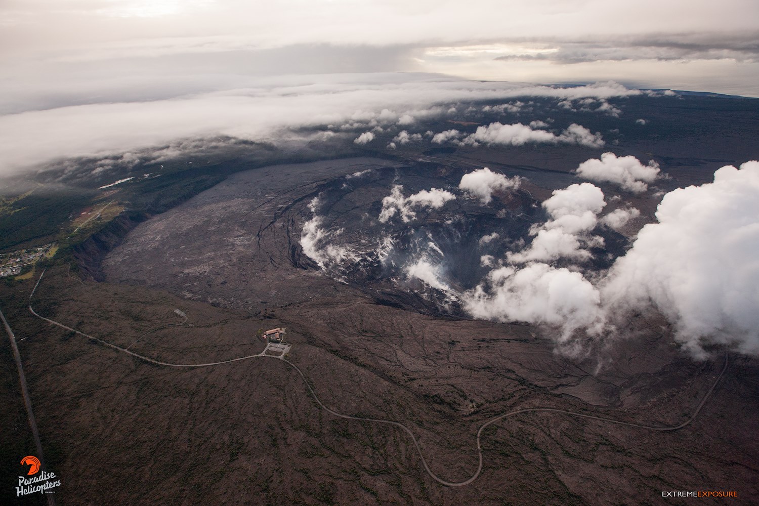
Kilauea , Hawaii :
19°25’16 » N 155°17’13 » W,
Summit Elevation 4091 ft (1247 m)
Current Volcano Alert Level: ADVISORY
Current Aviation Color Code: YELLOW
Activity Summary:
Kīlauea Volcano is not erupting. Rates of seismicity, deformation, and gas release have not changed significantly over the past week. Deformation signals are consistent with slow magmatic recharge within the middle East Rift Zone (ERZ).
Observations:
Low rates of seismicity continue across the volcano, with events occurring primarily in the summit and south flank regions. Slow inflationary tilt continues in the middle ERZ. Sulfur dioxide emission rates have been below detection limits in the LERZ since early September, though minor amounts of volcanic gas are still present. Sulfur dioxide emission rates from the summit and Puʻu ʻŌʻō remain low.
Hazards remain in the LERZ eruption area and at the Kīlauea summit. Residents and visitors near recently active fissures and lava flows should heed Hawaii County Civil Defense and National Park warnings, and be prepared, if necessary, to self-evacuate in the unlikely event of renewed activity. Please note that Hawaii County maintains a closure of the entire lava flow field and vents and prohibits access unless authorized through Civil Defense.
The Hawaiian Volcano Observatory (HVO) continues to closely monitor Kīlauea’s seismicity, deformation, and gas emissions for any sign of reactivation. HVO maintains visual surveillance of the summit and the East Rift Zone with web cameras and occasional field visits.
HVO will continue to issue a weekly update (every Tuesday) and additional messages as warranted by changing activity.
Source : HVO
Photo : Bruce Omori / Paradise Helicopters
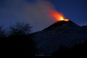
Indonésie , Agung :
Activity Level at level III (SIAGA). G. Agung (3142 m) has been erupting since November 21, 2017. The last eruptions took place on December 30, 2018 and January 10, 2019.
From yesterday until this morning, the weather was clear to cloudy with light to moderate winds blowing west and east. The volcano is clearly visible until it is covered with fog. Smoke from the main crater was observed 50 meters above the summit, white with low intensity.
Through the seismographs, on January 16, 2019, it was recorded:
1 volcanic earthquake
1 shallow volcanic earthquake
1 local tectonic earthquake
5 distant tectonic earthquakes
On 17 January 2019 (00: 00-06: 00 WITA), the seismic activity was not recorded.
Recommendation:
The communities around G. Agung and mountaineers / visitors / tourists must not be present, must not carry out activities in the estimated risk zone, ie in all areas within a radius of 4 km around the crater from Mount Agung.
The estimated danger zone is dynamic and continues to be evaluated. It can be modified at any time to follow the most recent observation data from G. Agung.
Communities living and traveling around streams from Gunung Agung are sensitized to the potential secondary hazard in the form of lahar descents that can occur especially during the rainy season and if the eruption material is still exposed in the rainy season. the peak area.
Level III (SIAGA) status applies only within a 4 km radius, as indicated above. Outside the danger zone, the activity can run normally while remaining safe, but must remain vigilant.
VONA:
The last VONA code sent a color code ORANGE, published on January 10, 2019 at 8:23 pm, depending on the eruption with a height of the column of ash that can not be observed because the mountain was covered with fog. The magnitude of the eruption event was 22 mm and the quake duration was 266 seconds.
Source : PVMBG.
Photo : Auteur inconnu.
Japan , Kuchinoerabujima :
the Japanese volcano erupted on Thursday, January 17, spewing ash and smoke 6 kilometers into the air over the small southern island.
There were no reports of injuries or damage from the eruption on Kuchinoerabu, in the far south of Japan.
A local official said there had been no evacuations on the island, which is home to just 109 people.
Images broadcast by NHK showed large plumes of ash and grey smoke billowing above the island, which has regularly been affected by eruptions.
« We heard a huge explosion and there was shaking like an earthquake, » a resident told the broadcaster.
The meteorological agency said the eruption occurred shortly after it had issued a new warning.
« There have been eruptions there since last year but we sent an alert out (this morning) for this latest eruption as it will have a wider impact, » said Jun Fujimatsu, an official at the agency’s volcanic activity division.
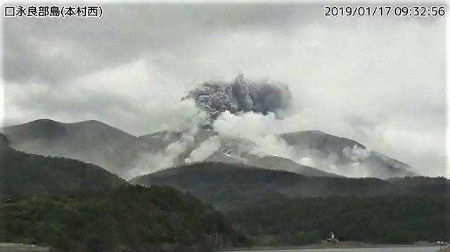
This handout grab from the Japan Meteorological Agency’s live webcam on January 17, 2019 shows the eruption on Kuchinoerabu Island in Yakushima, Kagoshima prefecture. Handout photo from Japan Meteorological Agency/AFP
« We have maintained a level 3 warning, which means a ban on entering the volcano area, » he told AFP.
« There are several craters at the volcano… The danger zone is two kilometers (1.2 miles) from the Shindake crater, » he added.
« We do not think the latest eruption will engulf the entire island. »
Government spokesman Yoshihide Suga said the plume of smoke and ash from the eruption rose 6,000 meters.
« But there is no impact on the community and no injury or damage has been reported, » he told reporters.
There are currently « 71 households comprising 109 people living on the island, including some who are just a few kilometers from the crater, » local official Shogo Sado told AFP.
He confirmed no evacuations had yet been ordered but said preparations were being made in case it became necessary to move people, some of whom are elderly and frail.
In 2015, all 140 people living on the island were evacuated after a violent eruption that sent black clouds up as high as 9,000 meters (29,500 feet) and produced a 5-minute volcanic quake.
Source : rappler.com
Photo : Agence météorologique japonaise / AFP
La Guadeloupe , la Soufrière :
Wednesday, January 16, 2019 at 18:45.
Sequence of earthquakes in La Soufrière area of Guadeloupe – Basse Terre
The sequence of volcanic earthquakes that began in the La Soufrière volcano area on January 8th at 00:59 local time (January 8th 4:59 am Universal Time *, UT) ended on Wednesday January 16th at 8:12 am (GMT *, UTC ). During this sequence 621 earthquakes were recorded.
The earthquakes were of very small magnitude (M <1). The events are located at a depth of <2.5 km under the summit of the dome of La Soufrière. No earthquakes were reported felt by the population.
The alert level remains: yellow, vigilance
Source : Direction de l’OVSG-IPGP .
Photo : goquidearth.com
Mexico , Popocatepetl :
January 16th at 1:40 pm (January 16th at 19:40 GMT)
Update.
At 12:44, began an ash emission that lasted 25 minutes. The seismic signal associated with this event was a mixture of harmonic tremor and low frequency high frequency. In the first minutes, the height of the column reached 1000 m, then decreased to 500 m. The ashes were dispersed to the east-north-east. We can therefore expect a fall of ashes in the cities of Santiago Xalitzintla, Nealtican, Huejotzingo and other cities in the area.
In the past 24 hours, 244 exhalations have been identified through the surveillance systems of the Popocatépetl volcano, with the emission of water vapor, gas and ash. An explosion was recorded today at 04:03 and the emission of incandescent fragments was observed on the slopes of the volcano at a distance of 1.5 km. In addition, three volcano-tectonic events were recorded, one yesterday at 21:52 and two today at 08:13 and 08:19 with a magnitude of M2,4, M1,5 and M1,5, respectively, as well as 6 minutes of harmonic tremor. low amplitude.
At the time of this report, there is visibility on the crater of the volcano, any emission will be dispersed in direction North-East.
CENAPRED urges DO NOT APPROACH the volcano and especially the crater, because of the risk of falling ballistic fragments, and in case of heavy rains to move away from the bottom of the ravines because of the risk of landslides and flows of mud.
The Popocatepetl warning light is located at Amarillo Phase 2.
Source : Cenapred.
Photo : seemexico.com