December 27 , 2018.
Back. So many things have happened in a few days …
Italy / Sicily , Etna :
The eruption of Mount Etna which began on December 24, 2018, by Marco Neri.
On the morning of December 24, 2018, a new eruption of Etna began. The phenomenon was characterized by the intrusion of a magma dyke on the upper flank of the volcano, generating an intense seismic swarm and remarkable deformations of the soil.
The seismic swarm started at 8:30 UTC, or 9:30 local time, and involved the Etna building in different areas, with epicentres located mainly near the craters of the summit and in the Valle del Bove , as well as hypocentres located 0 and 3 km below sea level. During the first three hours, approximately 300 shocks occurred (Figure 1); among them, high-energy events were mainly located in the summit area. Subsequently, seismicity affected the Valle del Bove with shocks of magnitude greater than or equal to M 4.0.
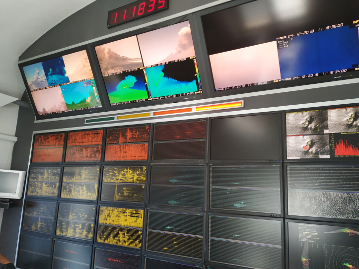
Figure 1 – Control panel of the operating room of the National Institute of Geophysics and Volcanology – Osservatorio Etneo, including the seismic swarm (panels below) and video surveillance cameras (top panels), the morning of December 24, 2018 (Photos of Mr. Neri).
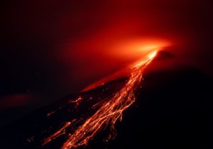
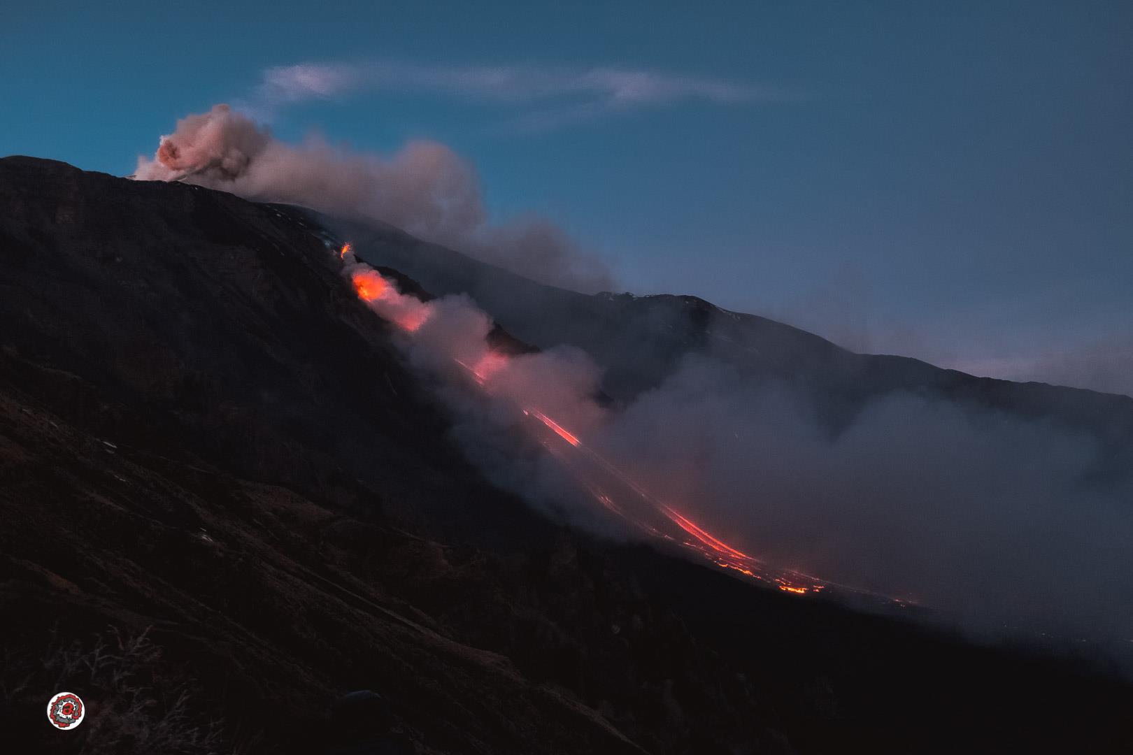
The onset of the seismic swarm coincided with an increase in gaseous emission intensity from the summit craters. During the morning, from the Bocca Nuova and the Northeast crater, isolated emissions of brown / reddish and gray ash occurred. Around 11:00 UTC (12 hours, Italian time), an eruptive fissure about 2 km long was opened and oriented in the NNO-SSE direction (Figure 2).
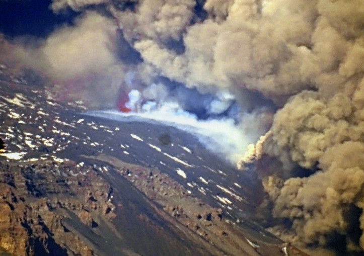
Figure 2 – An eruptive fissure opened near the edge of the western wall of Valle del Bove, taken on December 24, 2018 (photo by B. Behncke).
The eruptive fissure extended from the southeastern base of the new south-east crater to the west wall of the Valle del Bove, reaching a minimum altitude of about 2,400 meters above sea level. A second small eruptive fissure opened a little further north, at about 3000 meters above sea level, between the New Southeast Crater and the Northeast Crater, and almost exclusively produced a weak strombolian activity for a few minutes. dozens of minutes. At the same time, the Northeast crater and the Bocca Nuova also produced a continuous strombolian activity of varying intensity. Overall, the ash cloud (Figure 3) generated by all eruptive vents produced a very thick and dark ash plume, driven by the wind in the southeast quadrant of the volcano.
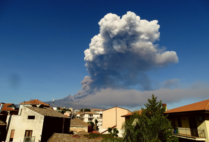
Figure 3 – Eruptive cloud produced by the opening of the eruptive fracture, taken from the south on December 24, 2018 (photo by B. Behncke).
Volcanic ash mainly fell in the vicinity of Zafferana Etnea and Santa Venerina (Figure 4).
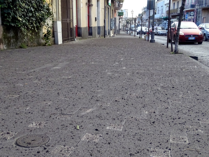
Figure 4 – Volcanic ash drop on a sidewalk at Zafferana Etnea, December 24, 2018 (photo by B. Behncke).
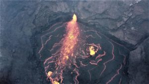
During its propagation, the eruptive fissure opened in the Valle del Bove fed lava flows that completely crossed the west wall of the valley, reaching its bottom and settling at 17:00 UTC on December 24, at varying altitudes. 1650 and 1800 meters (Figure 5).
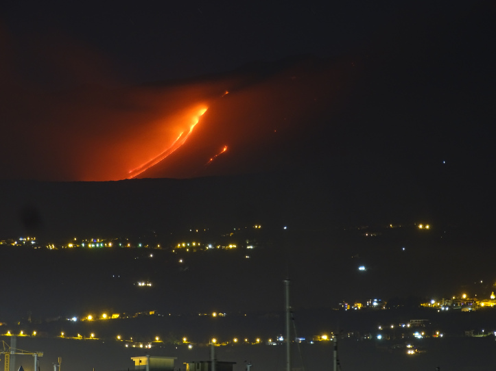
Figure 5 – Lava flows fed by the eruptive crack opened on December 24, 2018 along the western wall of Valle del Bove. (Photo by B. Behncke)
In the early hours of December 25, the eruption is still in progress. A lava flow continues to flow into the Valle del Bove, fed by the eruptive fracture whose lower mouth is located at about 2400 m altitude, along the western wall of the valley. The summit craters, and in particular the craters of the Bocca Nuova and the Northeast Crater, produce a continuous Strombolian activity that feeds a gaseous plume rich in volcanic ash. The seismic swarm that accompanies the eruption continues; Since yesterday morning, for about twenty-four hours, more than seven hundred and fifty seismic shocks have been recorded by the seismic network of the INGV Osservatorio Etneo.
Historical notes on the lateral eruptions in Valle del Bove:
The Valle del Bove is an impressive erosional depression formed about 10,000 years ago by the collapse of the area that affected the eastern flank of the volcano. The valley is over 1000 meters deep (along its west wall), about 5 km wide and about 7.5 km long, with a long axis in the ONO-ESE direction. Due to its position and morphology, the valley easily accommodates the lava flows that have emerged from the top of the volcano, particularly the New Southeast Crater and its surrounding mouths. In addition, the western wall of the valley contains numerous eruptive fractures that can be attributed, structurally, to the eruptive activities of the North and South sectors of Etna, namely eruptive fractures oriented in the directions SO- NE and NE-SO respectively. When the eruptions last long enough (months or years), the lava flows have the potential to extend beyond the eastern limit of the Bove Valley, threatening the urban centers that are located there.
In this region, the most recent major eruption took place in 1991-1993, when the lavas completely buried the southern part of the valley, completely filled the underlying Val Calanna and then seriously threatened the city of Zafferana Etnea, reaching the suburbs. Previously, other dangerous secondary eruptions for inhabited centers on the east side of Mount Etna had occurred in 1989, 1979, 1950-1951, 1851-1853, 1689, 1446 and 1285.
Source : INGV Vulcani , Marco Neri .
Find the article: https://ingvvulcani.wordpress.com/2018/12/25/leruzione-laterale-etnea-iniziata-il-24-dicembre-2018/
Photos : Marco Neri , Boris Behncke , Luca Giuffrida .
Indonesia , Anak Krakatau :
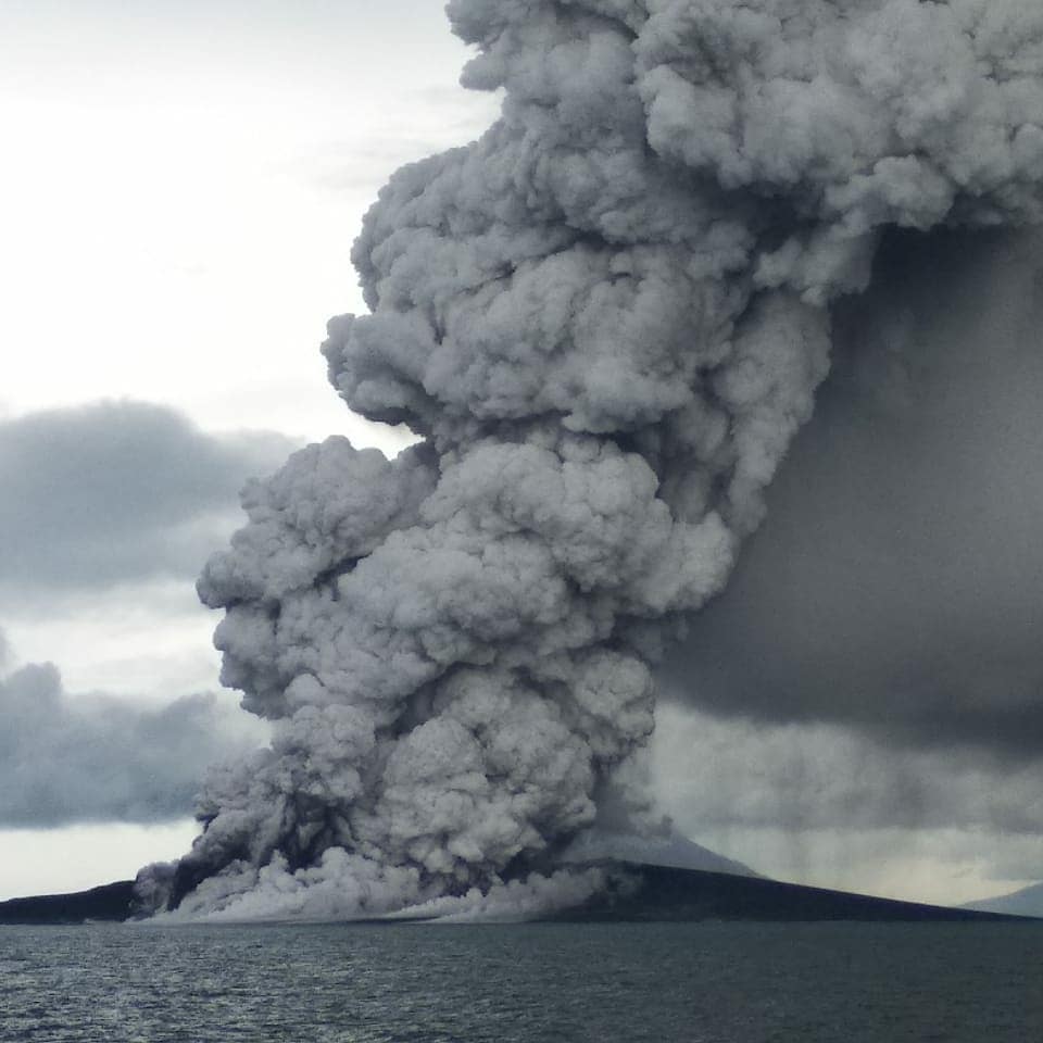
On December 22, as in previous days, Anak Krakatau continued to erupt. Visually, the eruptions exhibited high smoke ranging from 300 to 1500 meters above the top of the crater. In seismicity, earthquakes were recorded continuously with excessive amplitude (58 mm). At 9:03, an eruption occurred and after a long time, information on the tsunami was provided. On the basis of the satellite images received by the PVMBG, most of Anak Krakatau ‘s body was lost, which would have subsequently caused tsunamis in several areas of Lampung and Banten provinces.
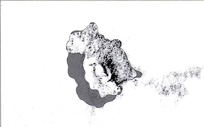
Map of Anak Krakatau after the landslide on December 22, 2018, by Citra Sentinel. The red mark shows the missing part of Anak Krakatau’s body compared to the sight of 11 November 2018.
After the tsunami, the activity of Anak Krakatau is still high. Visually, the volcano is clearly visible until it is covered with fog. It was observed that the main crater emitted a gray / black smoke, with a low intensity, up to a height of about 500 meters above the summit, with winds blowing weakly to moderately to the north and south-west. . Seismicity is still dominated by continuous tremor with an amplitude of 32 mm (dominant value of 25 mm). On 26 December, volcanic ash was reported in several areas, including Cilegon, Anyer and Serang. The PVMBG emergency response team immediately conducted a field audit to confirm the incident and collect volcanic ash, which will then be analyzed by the PVMBG office.
The map of the disaster-prone region (KRB) shows that almost the entire body of Mount Anak Krakatau, with a diameter of ± 2 km, is a disaster-prone area. The potential hazards of Anak Krakatau ‘s activities today are jets of incandescent materials, lava flows from the center of the eruption and hot clouds pointing south. Although the distribution of volcanic ash depends on the direction and speed of the wind, the activity level of Anak Krakatau was increased from level II (WASPADA) to level III (SIAGA) on 27 December 2018 at 05:00. With regard to level III activity level (Siaga), it is recommended not to allow the community to approach Mount Anak Krakatau within 5 km radius of the crater. When ashes fall, people are asked to wear a mask and glasses during their activities outside the home. Residents of the coastal areas of Banten and Lampung Provinces should remain calm and can carry out their activities as usual, always following the instructions of the local BPBD.
Morphological conditions:
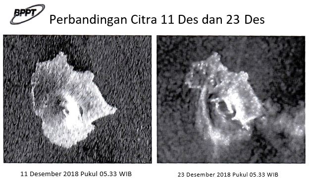
According to Sentinel Image data dated December 11, 2003 and December 23, 2018, it appears that some of the slopes in the West to South sectors appear to have undergone landslides, as shown by the comparison of images before and after the tsunami .
Since December 20, 2018, it has been observed that there is on the volcano a type of Surtseyenne eruption, namely that the flow of lava or magma comes out directly in contact with water. This means that the volume of magma released increases and the crater hole gets bigger. It may be that a new crater is digging closer to the water level.
From December 22, 2018 to the present, the eruption took place without interruption. Erupting noises are heard several times a minute. Currently, eruptive activity is still in progress, notably in the form of Strombolian eruptions accompanied by incandescent lava flows and hot clouds.
On December 26, 2018, the eruption took the form of hot clouds and Surtseyenne eruption. These hot clouds resulted in ash rains, including those recorded on December 26, 2018 at 17:15 WIB. At Kalianda Station, at 12 o’clock, a high intensity roar was reported.
Source : PVMBG
Photo : sukamdani_gunners543 Indonesian navy, warship , via Sherine France.
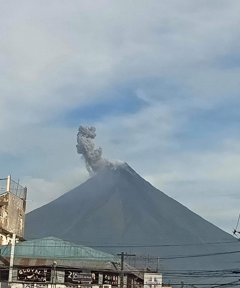
Philippines , Mayon :
MAYON VOLCANO BULLETIN 27 December 2018 10:00 A.M.
Two (2) phreatic eruption events were observed at 8:17 AM and 8:28 AM today. These events generated grayish to grayish white ash plume that rose 600 meters and 200 meters above the summit, respectively, before drifting southwest.
Prior to these events, Mayon Volcano’s seismic monitoring network recorded one (1) volcanic earthquake during the 24-hour observation period. Fair crater glow from the summit could be observed at night. Sulfur dioxide (SO2) emission was measured at an average of 1943 tonnes/day on 25 November 2018. Precise leveling data obtained on 22-31 October 2018 indicate inflation of the edifice in the southeast sector while the north sector indicate short-term deflation relative to 30 August to 3 September 2018. Overall however, the volcano generally remains inflated relative to 2010 baselines. Electronic tilt data further show pronounced inflation of the mid-slopes beginning 25 June 2018, possibly due to aseismic magma intrusion deep beneath the edifice.
Alert Level 2 currently prevails over Mayon Volcano. This means that Mayon is at a moderate level of unrest. DOST-PHIVOLCS reminds the public that sudden explosions, lava collapses, pyroclastic density currents or PDCs and ashfall can still occur and threaten areas in the upper to middle slopes of Mayon. DOST-PHIVOLCS recommends that entry into the six kilometer-radius Permanent Danger Zone or PDZ and a precautionary seven kilometer-radius Extended Danger Zone or EDZ in the south-southwest to east-northeast sector, stretching from Anoling, Camalig to Sta. Misericordia, Sto. Domingo must be strictly prohibited. People residing close to these danger areas are also advised to observe precautions associated with rockfalls, PDCs and ashfall. Active stream/river channels and those identified as perennially lahar-prone areas on all sectors of the volcano should also be avoided especially during extreme weather conditions when there is heavy and prolonged rainfall. Civil aviation authorities must advise pilots to avoid flying close to the volcano’s summit as airborne ash and ballistic fragments from sudden explosions and PDCs may pose hazards to aircrafts.
Source : Phivolcs.
Photo : CNN Philippines , via Sherine France .
Peru , Sabancaya :
An average of 19 EXP / day was recorded. The activity associated with fluid movement (long period type) continues to predominate. Earthquakes associated with the rise of magma (hybrid types) remain very few and low energy.
The columns of gas and eruptive ash reached a maximum height of 2900 m above the crater. The dispersion of these materials occurred within a radius of about 40 km, mainly to the Northeast, East and Southeast.

The volcanic gas (SO2) flow recorded on December 17th a maximum value of 2300 tons / day, considered as a significant value.
The deformation of the surface of the volcanic building presents important changes.
The MIROVA satellite system recorded 2 thermal anomalies, with values between 2 and 7 MW VRP (Radiated Volcano Energy).
In general, eruptive activity maintains moderate levels. No significant changes are expected in the coming days
Source : IGP