December 17 , 2018.
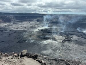
Chile , Planchon – Peteroa :
Special Report on Volcanic Activity (REAV), Maule Region, December 16, 2018, 07:10 local time (mainland Chile).
The National Geological and Mining Service of Chile (Sernageomin) publishes the following information, obtained from the surveillance equipment of the National Volcanic Monitoring Network (RNVV), processed and analyzed at the Volcanological Observatory of the Southern Andes (OVDAS):
During the past few hours, the Planchon Peteroa volcanic complex has recorded an increase in its seismic activity, characterized by the recording of low intensity tremor pulses (less than 4 cm2) which are associated with low altitude pulsatile degassing (800m), greyish , and particulate emissions. During the night, it was noted an incandescence on the images of the web camera located in the vicinity of the volcanic complex.

In this context, it is possible that new events such as the one recorded in the last few hours will occur, and include more energy, as described in some previous activity reports.
OBSERVATIONS:
At the time of issuing this report, the tremor signal is maintained with fluctuations in its amplitude. It is expected that a degassing is observed with the same memes as above.
The level of volcanic technical alert remains at the level: Yellow.
Sernageomin continues online monitoring and will inform in a timely manner about any changes observed.
Source : Sernageomin.
Photo : Jose Thomas Carvaja / Aton Chiles.
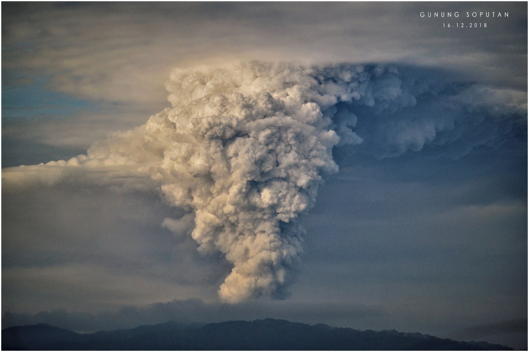
Indonesia , Soputan :
Level III Activity Level (SIAGA). The Soputan volcano (1784 m altitude) has increased its volcanic activity.
Since yesterday and until this morning, the volcano was clearly visible until they were covered with fog. The smoke from the crater was observed at an altitude of 7500 meters, white / black with a medium to thick intensity. Observation of an eruption of 7,000 m, gray / black. The wind is blowing weak to moderate in the southeast.
By the seismographs, on December 16, 2018, it was recorded:
1 eruption earthquake
17 emission earthquakes
274 bursts of earthquake
9 shallow volcanic earthquakes
56 deep volcanic earthquakes
A continuous tremor of amplitude 4 to 40 mm, with a dominant value of 40 mm.
On December 17, 2018 (00: 00-06: 00 WITA) it was recorded:
82 emission earthquakes
61 bursts of earthquake
8 shallow volcanic earthquakes
5 deep volcanic earthquakes
Continuous tremor with amplitude 0.5 to 4 mm, with a dominant value of 1 mm
Recommendation:
The community must not have activities within a radius of 4 km around the summit of G. Soputan and in the area of the West-South-West sector until 6.5 km, crater opening area, in order to avoid the threat of lava and hot clouds.
VONA:
The latest code VONA sent the RED color code, published on December 16, 2018 at 5:54 AM WITA, related to an eruption with a maximum column height of 8809 meters above sea level or about 7000 meters above the summit.
Source : PVMBG.
Photo : Maikel Parengkuan
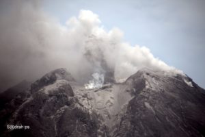
Indonesia , Merapi :
REPORT ON THE ACTIVITY OF MERAPI, 7-13 December 2018
I. RESULTS OF OBSERVATION
Visual:
The weather is sunny in the morning, the afternoon and the foggy evening. The smoke observed from the crater is white, thick, with low gas pressure. A maximum height of 200 m is observed from the Mount Merapi observation post in Kaliurang on December 10, 2018.
Dome of lava and morphology of the peak:
Morphological analysis based on photos of the Southeast sector showed morphological changes in the form of dome growth. Annex 1.a presents morphological analysis of the peak via the Deles camera station.
As of December 13, 2018, the volume of the lava dome was 359,000 m3 with an average growth rate of 2,200 m3 / day, about the same as the previous week. Currently, the lava domes are still stable with a low growth rate (<20,000 m3 / day). Appendix 1.b presents an analysis of the lava domes from the Puncak camera stations.

Seismicity:
During this week, the seismic activity of Mount Merapi recorded 28 emission earthquakes (DG), 4 superficial volcanic earthquakes (VTB), 9 multiple-phase earthquakes (MP), 264 avalanche events (RF), 35 low frequency earthquakes (LF) and 12 tectonic earthquakes (TT). This week’s LF seismicity was higher than the week before.
Deformation:
The deformation of G. Merapi, which was monitored by EDM and GPS this week, showed no significant change.
SO2 emissions:
During this week, the DOAS (Differential Optical Absorption Spectroscopy) measurement gave an average value of maximum SO2 emissions from Mount Merapi at 79.98 tonnes / day, still within normal limits.
Rain and lahars:
This week, on December 10, 2018, the Mt. Merapi observation post enjoyed rain with a rainfall intensity of 51 mm / hour for 65 minutes. The station did not report either lahars or flow increases in the rivers downstream of Mount Merapi.

II. CONCLUSION AND ADVICE
Conclusion:
Based on the results of the visual and instrumental observations, it was concluded that:
1. The lava dome is currently in a stable state with a relatively low growth rate.
2. The volcanic activity of Mount Merapi is still quite high and is at the activity level « WASPADA ».
Suggestion:
With Mount Merapi’s WASPADA activity level, it is recommended to the Mount Merapi disaster management stakeholders as follows:
• A radius of 3 km around the summit of Mount Merapi must be prohibited for the activities of the population and climbing.
• If there is a significant change in Mount Merapi activity, the activity status of Mount Merapi will be re – examined.
• Regarding the timing of the rainy season, people moving around the rivers below Mount Merapi should be aware of the danger of lahars.
• It is recommended that local authorities socialize the current state of Mount Merapi.
Source : BPPTKG
Photo : MADS.
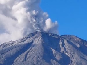
Mexico : Popocatepetl :
December 15, 11:00 am (December 15, 17:00 GMT).
During the last 24 hours, thanks to the monitoring systems of the Popocatépetl volcano, 34 exhalations have been identified, accompanied by water vapor, gas and light amounts of ash. In addition, an explosion was recorded yesterday at 12:37. During the night, it was possible to observe the crater, a little incandescence was observed at the time of certain exhalations.
At the time of writing, there is a slight emission of water vapor and gas that the winds are scattering in a preferential east-northeast direction.
CENAPRED urges NOT to APPROACH the volcano and in particular the crater, because of the risk of falling ballistic fragments, and in case of heavy rains, to move away from the bottom of the ravines because of the risk of landslides and of mudslides.
The Popocatepetl warning light is located at Amarillo Phase 2.
Source : Cenapred .