December 16 , 2018.
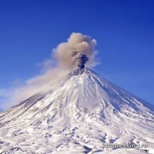
Alaska , Veniaminof :
56°11’52 » N 159°23’35 » W,
Summit Elevation 8225 ft (2507 m)
Current Volcano Alert Level: WATCH
Current Aviation Color Code: ORANGE
Relatively vigorous eruptive activity resumed at Veniaminof volcano on Thursday, December 13. A strong thermal anomaly was observed in satellite imagery and in nighttime webcam images over the past day. An eruption plume was also visible in some clear satellite images. The observations are consistent with lava fountaining at the cone in the ice-filled summit caldera. The eruption does not seem to be producing a lava flow, though this cannot be ruled out.
Veniaminof volcano is monitored with a local real-time seismic network, which will typically allow AVO to detect changes in unrest that may lead to a more significant explosive eruption. AVO combines seismic, infrasound, lightning, and satellite data for rapid detection of such events.
Source : AVO
Photo : McGimsey, R. G.
Chile , Planchon – Peteroa :
Special report on volcanic activity (REAV), Maule Region, December 14, 2018, 10:20 local time (mainland Chile).
The National Geological and Mining Service of Chile (Sernageomin) publishes the following information, obtained from the surveillance equipment of the National Volcanic Monitoring Network (RNVV), processed and analyzed at the Volcanological Observatory of the Southern Andes (OVDAS):
On Friday, December 14, 2018, at 09:57 local time, the surveillance cameras installed near the Planchon Peteroa volcanic complex recorded an emission of low-altitude particulate matter (800m), which dispersed towards East. It should be noted that this event was associated with a long period type seismic signal (LP) followed by a tremor type signal, with a reduced displacement value of 13.3 cm 2. There was no recorded seismicity prior to this event.
In this context, it is possible that new events such as the one recorded will occur, and include more energy, as described in some previous activity reports.
OBSERVATIONS:
At the time of issuing this report, the tremor signal is maintained following this emission of ash.
The level of volcanic technical alert remains at the level: Yellow.
Sernageomin continues online monitoring and will inform in a timely manner about any changes observed.
Source : Sernageomin .
Photo : J.Cardenas.
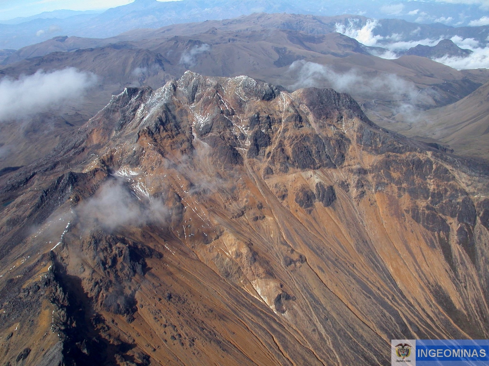
Ecuador , Chiles / Cerro Negro :
Special Report volcano Chiles-Cerro Negro N ° 1 – 2018.
Update of the seismic activity: decrease in the number of events after the recorded swarm
Summary :
The seismic swarm composed mainly of volcano-tectonic events or fractures, recorded on December 3 in the vicinity of the volcanic complex Chiles – Cerro Negro, lasted until December 6. During this episode, between 700 and 2500 daily events were counted. Currently, the level of activity has returned to that observed before the swarm.
Characteristics of the registered seismic swarm:
The seismic swarm started at about 6:00 UT (1:00 TL) on December 3 and during the first few hours, the event rate was the highest as shown in Figure 1. The earthquakes were of the volcano-tectonic type. that is, they came from the rock fracture.
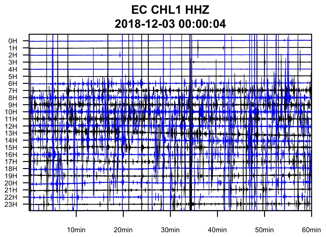
Figure 1. Seismogram of station CHL1 (Chiles 1) corresponding to December 3, 2018 where the increase in seismicity can be observed after 6:00 UT.
The swarm lasted 4 days. On the first day, approximately 2,500 events were recorded, followed by a gradual decrease until December 6, when approximately 700 events were counted. As of December 7, their numbers have decreased to less than 200 events per day, returning to levels observed on some occasions prior to this swarm (see Figure 2).
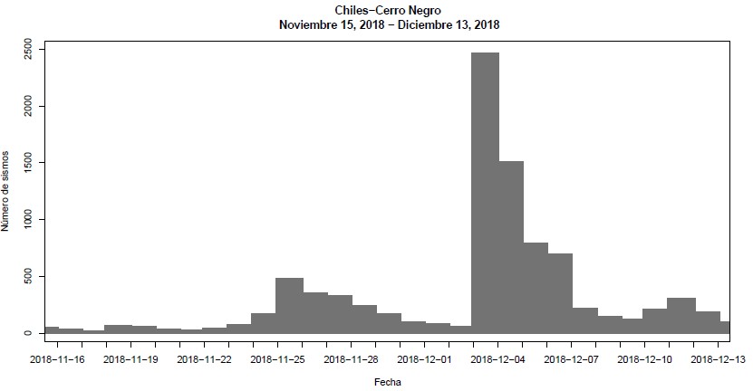
Figure 2. Number of earthquakes per day recorded in the CHL1 seismic station (Chiles 1) since November 15th. There is a notable increase in the number of events recorded on December 3 and a decrease since December 7.
The events of this seismic swarm took place on the southern flank of the Chiles volcano, at depths between 4 and 12 km below the summit level, see Figure 3.
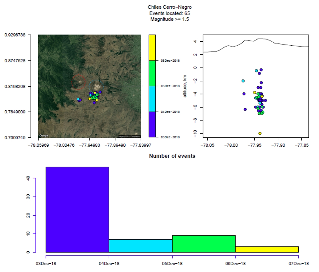
Figure 3. Location in plan and E-O section of 65 volcano-tectonic events of the seismic swarm recorded between December 3 and 6. The color scale corresponds to the date of the events. Red: Cerro Negro; Celeste: Chiles.
Most earthquakes in this swarm had a magnitude of less than 2 MLv (mean local magnitude, calculated as the amplitude of signals in the vertical components of several stations) and the maximum was 3.3 MLv; The Geophysical Institute did not receive reports from residents who would have felt any of these events.
On December 9 at 18:17 UT (13:17 TL), outside the swarm period, a magnitude 3.0 MLv earthquake (IGEPN) was recorded and reported as felt at the Pasto Observatory of the Geological Survey of Colombia.
Conclusions
The anomaly or seismic swarm lasted 4 days, during which approximately 5,500 events were counted. For the moment, the level of seismic activity is comparable to that observed before this swarm.
The GEOPHYSICAL INSTITUTE OF THE NATIONAL POLITICAL SCHOOL OF ECUADOR and the COLOMBIAN GEOLOGICAL SERVICE closely monitor the evolution of this seismic activity and the volcanic phenomenon and inform the changes detected
Source : IGEPN.
Photo : Ingeominas.
Vanuatu , Ambrym :
Update on Ambrym volcano activity issued by the Vanuatu Meteorology and Geohazards Department on 15th December 2018 at 11:57 pm:
Ongoing small-scale intra-caldera flank eruption near Marum crater with ash, gas, explosion, lava flow and lava fountain. People from Ambrym and neighboring islands may view volcanic ash and/or gas plumes, hear volcanic explosions and feel volcanic earthquakes. The volcanic Alert Level remains at Level 3. The Danger Zone for life safety is limited at the Danger Zone B which is about 2 km around Benbow and 4 km around Marum craters (including Maben-Mbwelesu, Niri-Mbwelesu and Mbwelesu).
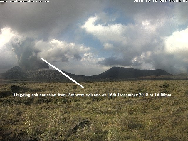
All tourism agencies, local authorities, people of Ambrym and the general public are reminded not to access this Danger Zone B. In this area volcanic ashes and gases may be unbearable. Villages from North, North-West and North-East of Ambrym including neighboring islands may experience impacts of ash and gas.
The Vanuatu Meteorology and Geohazards Department continues to closely monitor this volcano activity. More information will be provided as soon as necessary.
Source : Geohazard Vanuatu.
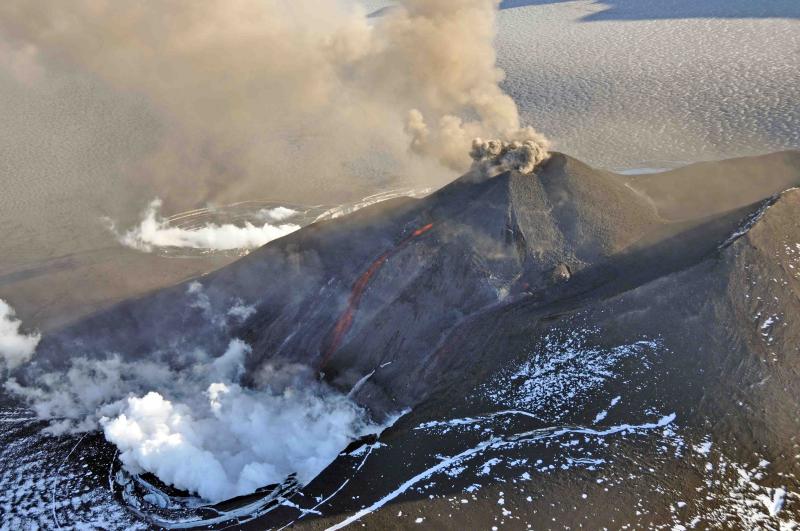
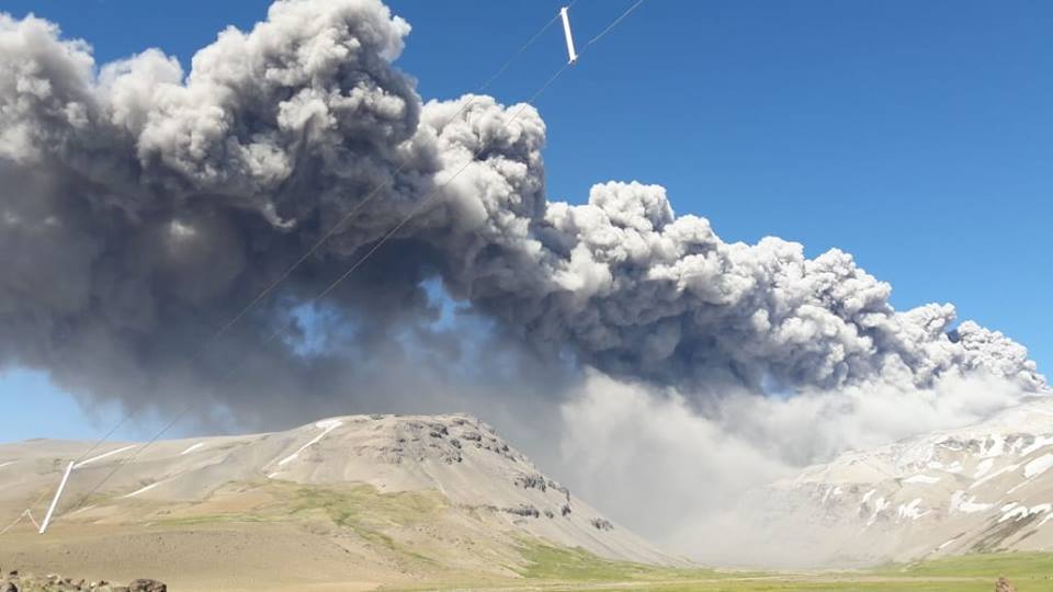
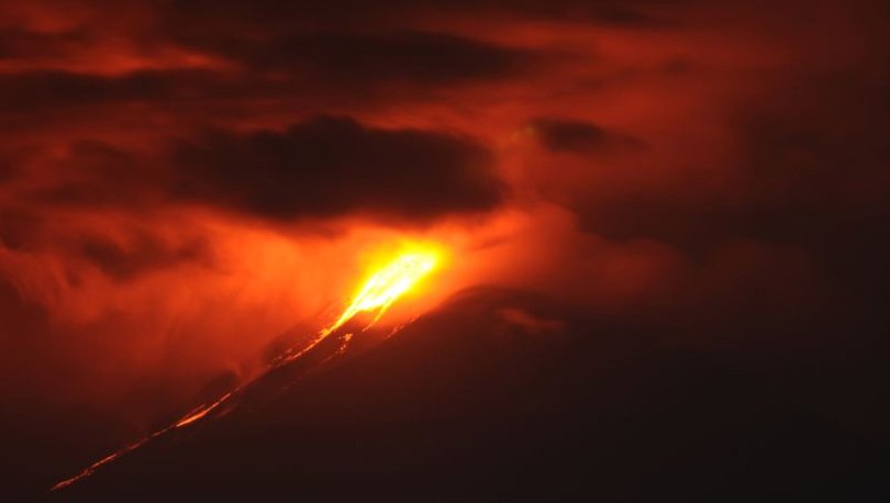
Indonesia , Soputan :
Eruption of G. Soputan, North Sulawesi, on December 16, 2018 at 5:40 am, with a height of the ash column observed at ± 7,000 m above the summit (± 8,809 m above sea level) . The column of ash was gray, of thick intensity and inclined towards the South-West. This eruption is recorded on a seismogram of maximum amplitude of 40 mm and a duration of ± 6 minutes 10 seconds.
The seismic activity is always high and the eruption ash column is always visible. Currently, G. Soputan is at Activity Level III (SIAGA) with recommendations:
The community must not have activities within a radius of 4 km around the summit of G. Soputan and in the zone of the sector West-South-West, up to 6.5 km which constitutes the opening zone of the crater , to avoid the threat of lava flow and avalanche clouds.

Be aware of the threat of descent from lahars, especially in the rivers that go down the slopes of G. Soputan, such as S. Ranowangko, S. Lawian, S. Popang and Londola Kelewahu. In case of ash rains, it is recommended that the community use a mask covering the nose and mouth to prevent airway disorders.
VOLCANO OBSERVATORY NOTICE FOR AVIATION – VONA.
Issued: December 15 , 2018
Volcano: Soputan (266030)
Current Aviation Colour Code: RED
Previous Aviation Colour Code: orange
Source: Soputan Volcano Observatory
Notice Number: 2018SOP12
Volcano Location: N 01 deg 06 min 52 sec E 124 deg 44 min 13 sec
Area: North Sulawesi, Indonesia
Summit Elevation: 5789 FT (1809 M)
Volcanic Activity Summary:
Eruption with volcanic ash cloud at 23h40 UTC (05h40 local). Eruption and ash emission is continuing.
Volcanic Cloud Height:
Best estimate of ash-cloud top is around 28189 FT (8809 M) above sea level, may be higher than what can be observed clearly. Source of height data: ground observer.
Other Volcanic Cloud Information:
Ash-cloud moving to southwest.
Remarks:
Seismic activity is characterized by continuous volcanic tremor.
Source : PVMBG. Magma Indonésie .
Photos : PVMBG , haberturk.com.