Novembre 15 , 2018.
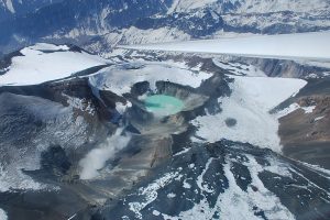
Colombia , Nevado del Ruiz :
Subject: Activity bulletin of the Nevado del Ruiz volcano.
The level of activity continues at the level: Yellow activity level or (III): Changes in the behavior of volcanic activity.
With regard to monitoring the activity of the Nevado del Ruiz volcano, the COLOMBIAN GEOLOGICAL SERVICE announces that:
During the past week, the seismicity caused by the fracturing of the rocks that make up the volcano has increased in number of earthquakes and released seismic energy compared to the previous week. These earthquakes were located mainly in the Arenas crater and east of the same crater and, to a lesser extent, in the northeastern, south-south-east and west, at depths ranging from between 0.4 and 5.7 km. The maximum magnitude recorded during the week was 1.6 ML (local magnitude) corresponding to the November 8 earthquake at 06:52 (local time) in the Arenas crater, at a depth of 1.7 km.
Seismicity related to fluid dynamics, within the channels of the volcanic structure, showed a similar level in number of earthquakes and released seismic energy compared to the previous week. This activity was characterized by the occurrence of earthquakes of variable energy levels of long period (PL), very long period (VLP) and tremors. The earthquakes were mainly located in the crater Arenas and its surroundings.
Volcanic deformations measured from electronic inclinometers, GNSS (Global Navigation Satellite System) stations and radar images have so far shown stability behavior without recording significant deformation processes of the volcanic structure.
The volcano continues to emit water vapor and gases into the atmosphere, among which is the sulfur dioxide (SO2), as evidenced by the values obtained by the SCANDOAS stations installed in the region of the volcano. satellite image analysis. During the week, the NASA FIRMS and MIROVA portals reported three low-energy thermal anomalies.
The column of gas, steam and ash reached a maximum height of 1600 m, measured at the top of the volcano on November 9th. The direction of column dispersion was governed by the direction of the wind in the area that prevailed at the beginning of the week to the southeast and northeast, and at the end of the week to the southwest and south-east. North West.
The Nevado del Ruiz volcano continues its activity at the level of yellow activity.
Source : SGC
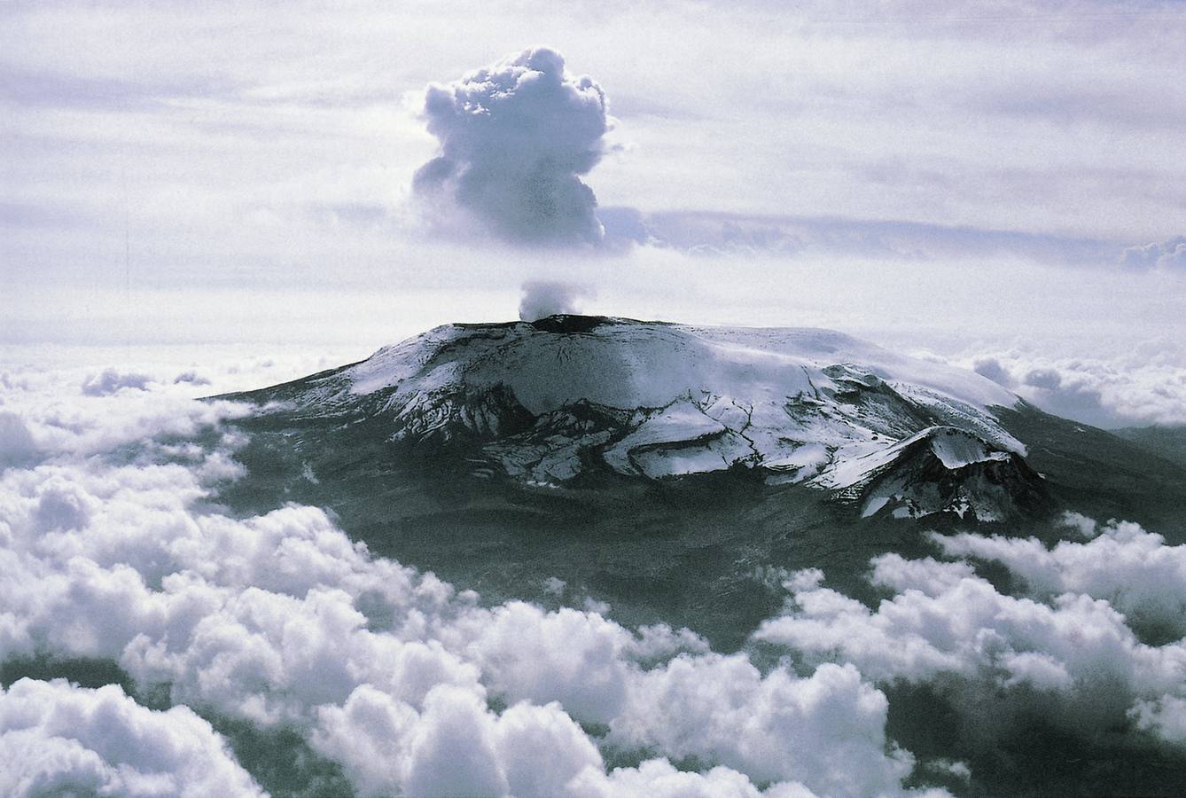
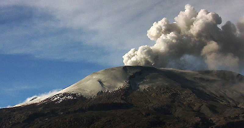
Japan / Kyushu Island, Sakurajima:
31.593°N, 130.657°E
Elevation 1117 m
JMA reported that the sulfur dioxide emission rate at Minamidake crater (at Aira Caldera’s Sakurajima volcano) was high at 1,100 tons/day on 6 November, an increase from the previous measurement of 1,000 tons/day recorded on 23 October. Very small eruptive events were occasionally recorded during 9-12 November. The Alert Level remained at 3 (on a 5-level scale).
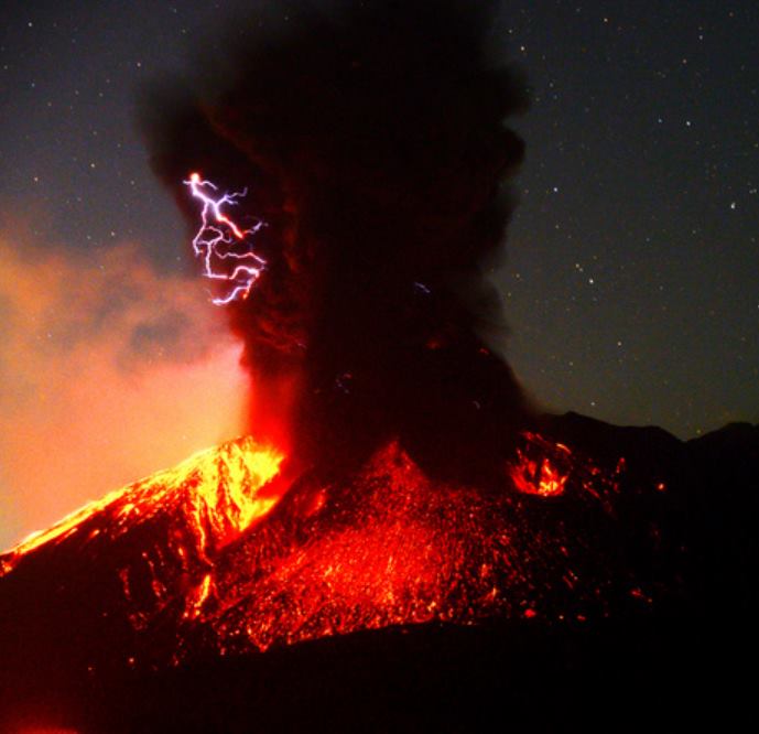
After a lull of a few weeks, the Sakurajima erupted on November 13 at 0:43 JST; the episode of the Minamidake upper vent was abrupt and significant with pyroclastic fallout on the flanks, and the emission of a plume, lightning at first, then expanding to 4,000 meters. Ashes are reported on Tarumi and Kanoya.
The Aira caldera in the northern half of Kagoshima Bay contains the post-caldera Sakurajima volcano, one of Japan’s most active. Eruption of the voluminous Ito pyroclastic flow accompanied formation of the 17 x 23 km caldera about 22,000 years ago. The smaller Wakamiko caldera was formed during the early Holocene in the NE corner of the Aira caldera, along with several post-caldera cones. The construction of Sakurajima began about 13,000 years ago on the southern rim of Aira caldera and built an island that was finally joined to the Osumi Peninsula during the major explosive and effusive eruption of 1914. Activity at the Kitadake summit cone ended about 4850 years ago, after which eruptions took place at Minamidake. Frequent historical eruptions, recorded since the 8th century, have deposited ash on Kagoshima, one of Kyushu’s largest cities, located across Kagoshima Bay only 8 km from the summit. The largest historical eruption took place during 1471-76.
Source:Japan Meteorological Agency (JMA), Bernard Duyck ( www.earth-of-fire.com ) , GVP.
Photo : Asahi Shimbun via Кирилл Баканов
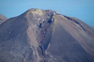
Indonesia , Anak Krakatau :
6.102 ° S, 105.423 ° E
Elevation : 338 m
Level II Activity Level (WASPADA). G.Anak Krakatau (338 m) has increased its volcanic activity since 18 June 2018.
Since yesterday and until this morning, the volcano was covered with fog. The smoke from the crater was found to be thin, white and 50 m above the summit. An eruption was observed, rising up to 300 to 1000 m above the gray peak. The wind was blowing weakly to the northeast.
The seismograph recorded on November 14, 2018:
175 earthquakes of eruption
24 shallow volcanic earthquakes.
4 deep volcanic earthquakes
81 emission earthquakes
A tremor is recorded continuously with an amplitude of 3 to 19 mm (dominant value 6 mm)
Recommendation:
People / tourists are not allowed to approach the crater within 2 km.
VONA:
The last issued VONA code was color-coded ORANGE, published on November 14, 2018 at 18:23, it was linked to an eruption with a column of ash about 1038 m above sea level or about 700 m above Summit. The ash column was moving east-northeast.
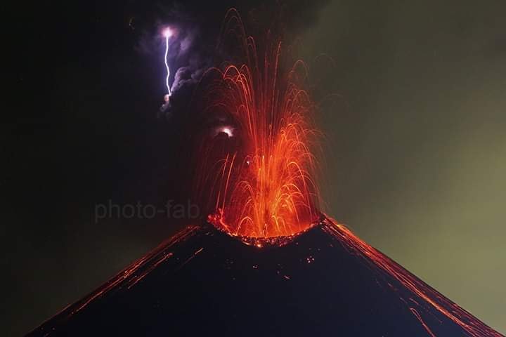
PVMBG reported that four events at Anak Krakatau occurred between 1620 and 1710 on 9 November. Each event lasted for 42-55 seconds, based on the seismic data, and produced ash plumes that rose 300-500 m above the crater rim and drifted N. An event at 0939 on 10 November generated an ash plume that rose 500 m and drifted N. There were 10 events recorded during 1029-1656 on 12 November, each lasting 38-117 seconds, and producing ash plumes that rose 200-700 m and drifted N. Four events were recorded during 0546-0840 on 13 November, each lasting 44-175 seconds, and producing ash plumes that rose as high as 800 m. The Alert Level remained at 2 (on a scale of 1-4); residents and visitors were warned not to approach the volcano within 2 km of the crater.
Source : PVMBG , GVP.
Photo : Fabrice Four.
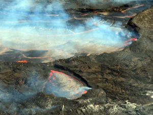
Alaska , Veniaminof :
56°11’52 » N 159°23’35 » W,
Summit Elevation 8225 ft (2507 m)
Current Volcano Alert Level: WATCH
Current Aviation Color Code: ORANGE
Veniaminof volcano continues to erupt, with minor lava spattering, effusion of a lava flow from the cone in the ice-filled summit caldera, and continuous, low-amplitude seismic tremor. Clear satellite views of the volcano over the past day showed strongly elevated surface temperatures from the active lava effusion. Webcam images showed incandescence from the summit overnight and a weak ash plume extending to the southwest today.
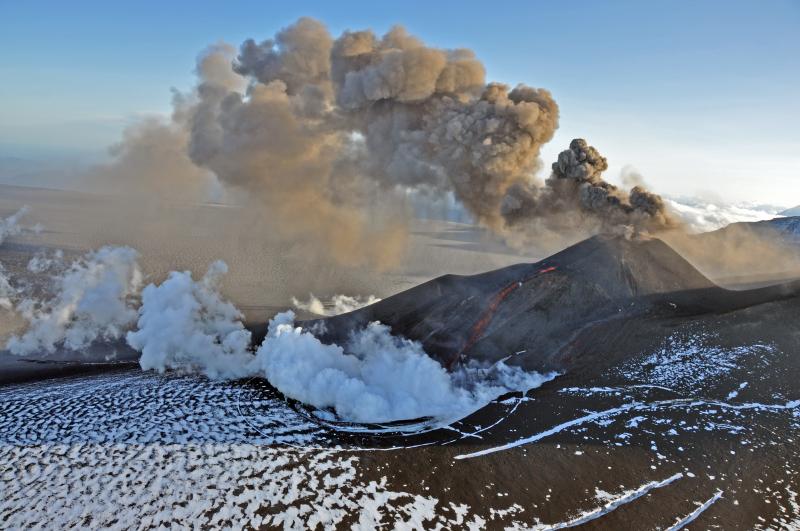
Diffuse ash and steam emissions continue and trace ashfall is possible in nearby communities under favorable wind conditions.
Veniaminof volcano is monitored with a local real-time seismic network, which will typically allow AVO to detect changes in unrest that may lead to a more significant explosive eruption. Rapid detection of such an event would be accomplished using a combination of seismic, infrasound, lightning, and satellite data.
Source : AVO
Photo : McGimsey, R. G. ( Aout 2013)