September 30 , 2018.
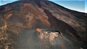
Chile , Planchon Peteroa :
During this period, 553 seismic events were recorded, of which 15 were classified as being of the volcano-tectonic (VT) type associated with rock fracturing processes, with maximum local magnitudes of M 1.5, located at 0 4km east of the active crater and at a depth of 3.5km.
In addition, 538 long-period (LP) type earthquakes, related to fluid dynamics within the volcanic system, the largest of which with a displacement value (ROC) of 20.5 cm have have been registered. Activity was localized in the crater area, with shallow depths.
The tremor signal continued to show a change in its dominant frequency, around 3.1 / 3.7 HZ, with reduced displacement values around 1 cm2. Its location is concentrated in the crater zone, with shallow depths.
The images provided by the IP camera show persistent low-energy, whitish-colored degassing with column heights no greater than 600 m above the level of the currently active crater. Only today, when this report is released, the color of the emissions has turned slightly gray, indicating the presence of a small amount of ash, at a low altitude.
From the data obtained by three (3) GNSS stations, which measure the deformation in the volcanic complex, no significant deformation was observed. On the other hand, the data recorded by the inclinometers installed near the volcanic complex, do not present variations related to the evolution of the internal dynamics of the volcano.
No anomalies were reported in sulfur dioxide (SO 2) emissions to the atmosphere in the volcanic complex sector, according to data obtained by the Ozone Monitoring Instrument (OMI) Group Sulfur Dioxide (O2). http: //so2.gsfc.nasa .gov /) and the National Service for the Environment, Data and Satellites (NESDIS) (http://satepsanone.nesdis.noaa.gov).

It has been reported 4 thermal warning in the area associated with the volcanic complex, with maximum values of 0.8 MW of Volcanic Radiated Power (VPR) according to data published by Middle Observation InfraRed of volcanic activity (Mirova) on its site Internet (http://www.mirovaweb.it/). Despite this low intensity, this is considered a significant change due to the historical absence of this type of anomaly on the volcanic complex.
The indications of the recordings suggest a greater excitation of the hydrothermal system activated by the heat of a magmatic body in depth, at the same time, a greater apparent permeability in the supposed tightness of said system. In the current scenario, the probability of triggering phreatic explosions or ash emissions increases.
For all this, the level of volcanic alert stays at the level:
YELLOW LEVEL: Changes in the behavior of volcanic activity – Probable time for an eruption: WEEKS / MONTH.
Observations: The current area of assignment is considered to be within 500 meters of the active crater area.
Source : Sernageomin.
La Réunion , Piton de la Fournaise :
Activity bulletin of Saturday, September 29, 2018 at 15:00 (local time).
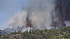
The eruption started on September 15th at 4:25 am local time continues. The intensity of the volcanic tremor (indicator of surface eruptive intensity) has remained relatively stable over the last 24 hours (Figure 1).
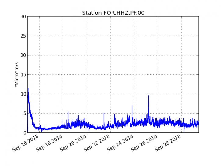
Figure 1: Evolution of the RSAM (indicator of the volcanic tremor and the intensity of the eruption) between 04h00 (00h UTC) on September 15th and 15h00 (11h00 UTC) on September 29th on the FOR seismic station, located near the crater Chateau Fort (2000 m altitude on the southeast flank of the terminal cone). (© OVPF / IPGP)
– No volcano-tectonic earthquake was recorded during the day of 28 September or during the current day.
– No significant deformation is noticeable.
– The surface flows estimated from the satellite data, via the HOTVOLC platform (OPGC – Clermont Auvergne University) ranged from 1 m3 / s to 2 m3 / s over the last 24 hours. Note that the eruptive activity now taking place mainly in lava tunnels, detection of anomalous hot spots are increasingly difficult and therefore these values of underrated flows.
Alert level: Alert 2-2 – Eruption in the Enclos.
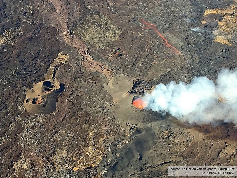
Source : OVPF.
Photo : Laura Huet / Cité du volcan via B . Duyck.
Indonesia , Kerinci :
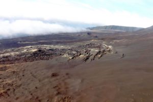
G. Kerinci (Jambi and West Sumatra)
Level of activity at Level II (WASPADA). G. Kerinci (3805 m altitude) erupts occasionally or as ash.
Since yesterday and until this morning, the images of the volcano were clear until it was covered with fog, the smoke from the crater was brown, of medium to thick intensity, the maximum height was 600 m. The wind is weak in the west and north-west.
The seismographic recording of September 29, 2018 noted:
54 earthquakes
1 shallow volcanic earthquake
Recommendation: People / tourists are not allowed to approach the crater at the top of G. Kerinci within 3 km of the active crater, the crater being the center of the eruptions and at any time an eruption can degrade life .
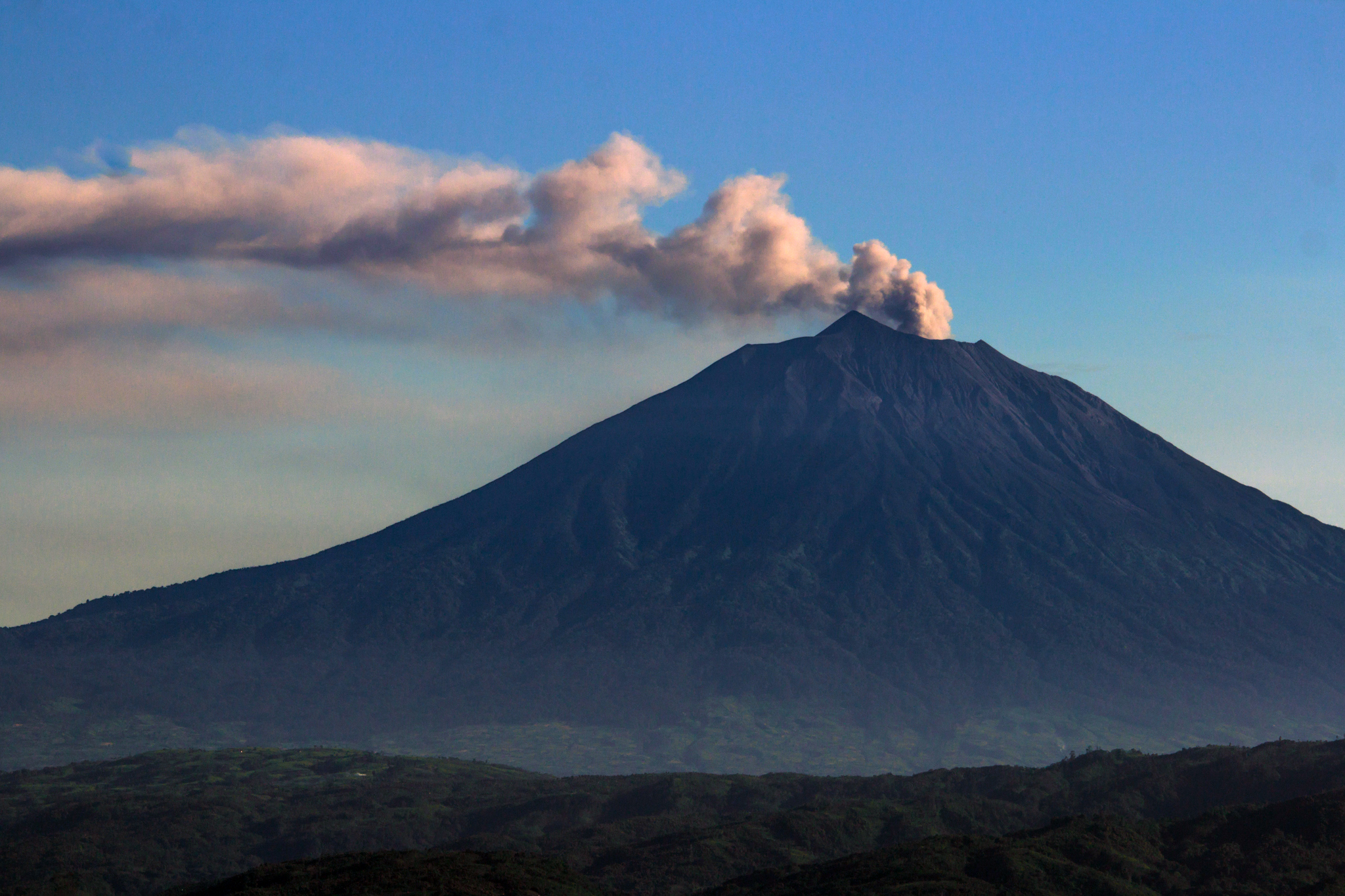
The 3800-m-high Gunung Kerinci in central Sumatra forms Indonesia’s highest volcano and is one of the most active in Sumatra. Kerinci is capped by an unvegetated young summit cone that was constructed NE of an older crater remnant. The volcano contains a deep 600-m-wide summit crater often partially filled by a small crater lake that lies on the NE crater floor, opposite the SW-rim summit of Kerinci. The massive 13 x 25 km wide volcano towers 2400-3300 m above surrounding plains and is elongated in a N-S direction. The frequently active Gunung Kerinci has been the source of numerous moderate explosive eruptions since its first recorded eruption in 1838.
This volcano is located within the Tropical Rainforest Heritage of Sumatra, a UNESCO World Heritage property.
Source : PVMBG, GVP.
Photo : GVP
Vidéo : Gilbert tv
Alaska , Katmai :
58°16’44 » N 154°57’12 » W,
Summit Elevation 6716 ft (2047 m)
Current Volcano Alert Level: NORMAL
Current Aviation Color Code: GREEN
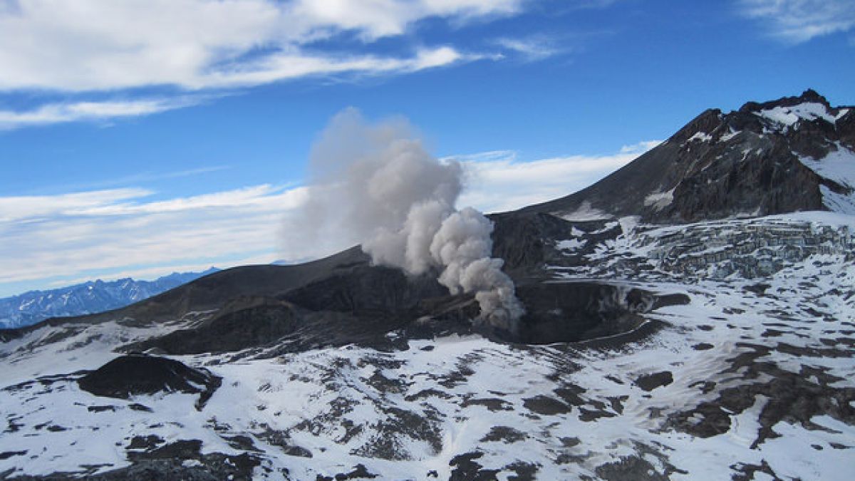
Strong southeast winds in the vicinity of Katmai and the Valley of Ten Thousand Smokes have picked up loose volcanic ash erupted during the 1912 Novarupta-Katmai eruption and carried it to the northwest today. No ash has been observed in cloudy satellite data, but pilot reports have confirmed a resuspended ash cloud below an altitude of 4,000 feet and extending to the east of King Salmon.
This phenomenon is not the result of recent volcanic activity and occurs during times of high winds and dry snow-free conditions in the Katmai area and other young volcanic areas of Alaska. No eruption is in progress. All of the volcanoes of the Katmai area (Snowy, Griggs, Katmai, Novarupta, Trident, Mageik, Martin) remain at color code GREEN.
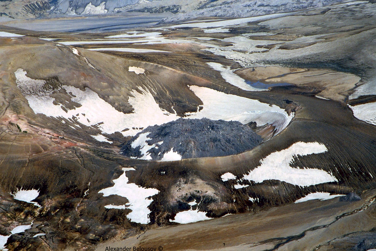
Prior to 1912, Mount Katmai was a compound stratovolcano with four NE-SW-trending summits, most of which were truncated by caldera collapse in that year. Two or more large explosive eruptions took place from Mount Katmai during the late Pleistocene. Most of the two overlapping pre-1912 Katmai volcanoes are Pleistocene in age, but Holocene lava flows from a flank vent descend the SE flank of the SW stratovolcano into the Katmai River canyon. Katmai was initially considered to be the source of the Valley of Ten Thousand Smokes ash flow in 1912.
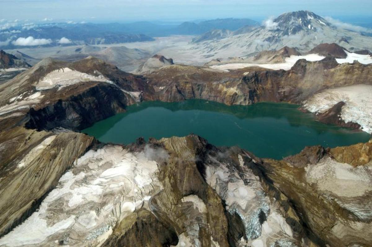
Katmai Calder, Glacier, and Mt Griggs » by U.S. National Park Service via Flickr Creative Common
However, the 3 x 4 km wide caldera of 1912 is now known to have formed as a result of the voluminous eruption at nearby Novarupta volcano. The steep walled young caldera has a jagged rim that rises 500-1000 m above the caldera floor and contains a 250-m-deep, still-rising lake. Lake waters have covered a small post-collapse lava dome (Horseshoe Island) that was seen on the caldera floor at the time of the initial ascent to the caldera rim in 1916. Post-1912 glaciers have formed on a bench within Katmai caldera.
Source : AVO, GVP.
Photos : A. Belousov ( Kvert) , parc national américain.