May 20 , 2018.
Pu’u ‘Ō’ō / Kilauea , Hawai :
Saturday, May 19, 2018, 1:33 AM HST (Saturday, May 19, 2018, 11:33 UTC)
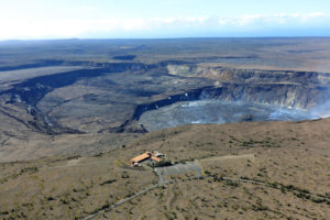
Kīlauea Volcano Summit.
At 11:58 PM Local time, a short-lived explosion at from Halema’uma’u created an ash cloud that reached up to 10,000 ft asl and was carried southwest by the wind. Possible trace ash fall may have occurred along Highway 11.
Additional explosive events that could produce minor amounts of ashfall downwind are possible at any time. Volcanic gas emissions at the summit remain high.
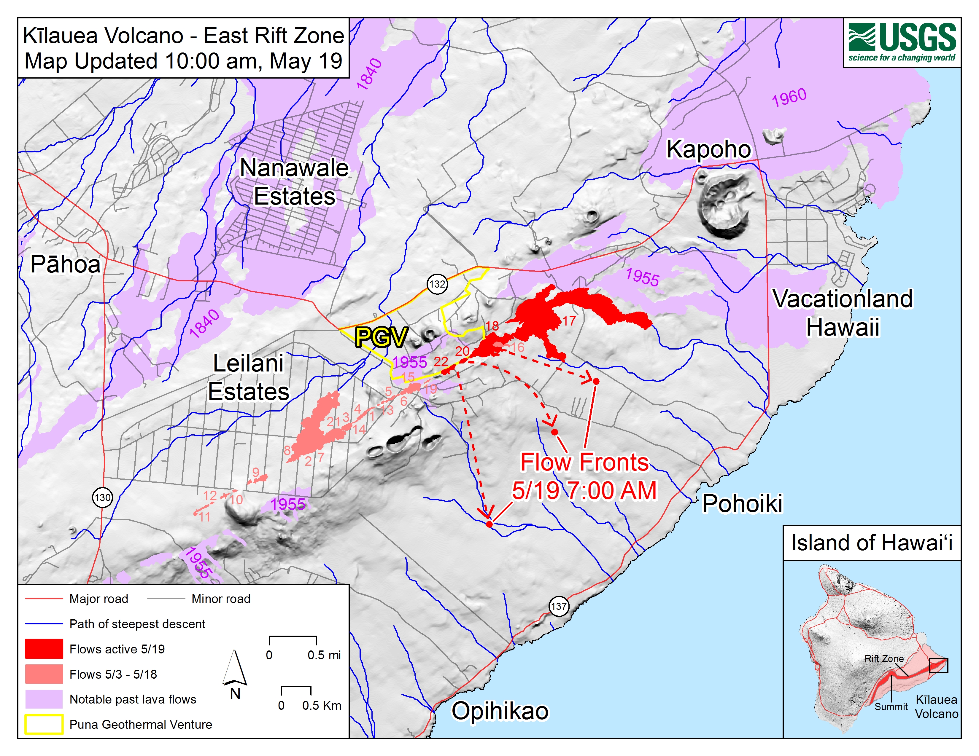
Kīlauea Volcano Lower East Rift Zone.
Eruption of lava and ground cracking in the area of Leilani Estates subdivision continues. A fast-moving pahoehoe lava flow that emerged from fissure 20 this afternoon continues to flow southeast. The flow has three main lobes. The easternmost is east of Pohoiki Road and is moving about 230 yards per hour. The westernmost of the lobes is near Malamaki Road and is moving at about 40 yards per hour. These rates may change with time and USGS crews are in the area to monitor flow advance. Other fissures remain weakly active and volcanic gas emissions remain elevated throughout the area downwind. Smoke from burning vegetation as lava flows advance is also contributing to poor air quality.

Additional ground cracking and outbreaks of lava are possible in the area. Residents downslope of the region of fissures should heed all Count of Hawaii Civil Defense messages and warnings.
Magma continues to be supplied to the lower East Rift Zone as indicated by the continued northwest displacement of a GPS monitoring station. Elevated earthquake activity continues, but earthquake locations have not moved farther downrift in the past couple of days.
USGS/HVO continues to monitor the lower East Rift Zone activity 24/7 in coordination with Hawaii County Civil Defense, with geologists onsite to track ongoing and new fissure activity and the advance of lava flows.
051918 6:00am Civil Defense Message.This is a Civil Defense Message for Saturday, May 19 at 6:00 in the morning.
Hawaiian Volcano Observatory reports a small steam explosion occurred in Halemaumau Crater last night around midnight. National Weather Service reports the ash plume rose to around 7000 feet. Trade winds pushed the ash plume to the southwest toward Kau, Pahala, and Naalehu. Residents of these areas are reminded to protect yourself from ash fallout by remaining indoors or by using dust masks.
Fissures east of Pohoiki Road near Lanipuna gardens continue to erupt, producing a slow moving lava flow. Four homes were destroyed, but no highways are threatened at this time.
Saturday, May 19, 2018, 9:16 AM HST (Saturday, May 19, 2018, 19:16 UTC)
Kīlauea Volcano Lower East Rift Zone.
Eruption of lava and ground cracking in the area of Leilani Estates subdivision continues.
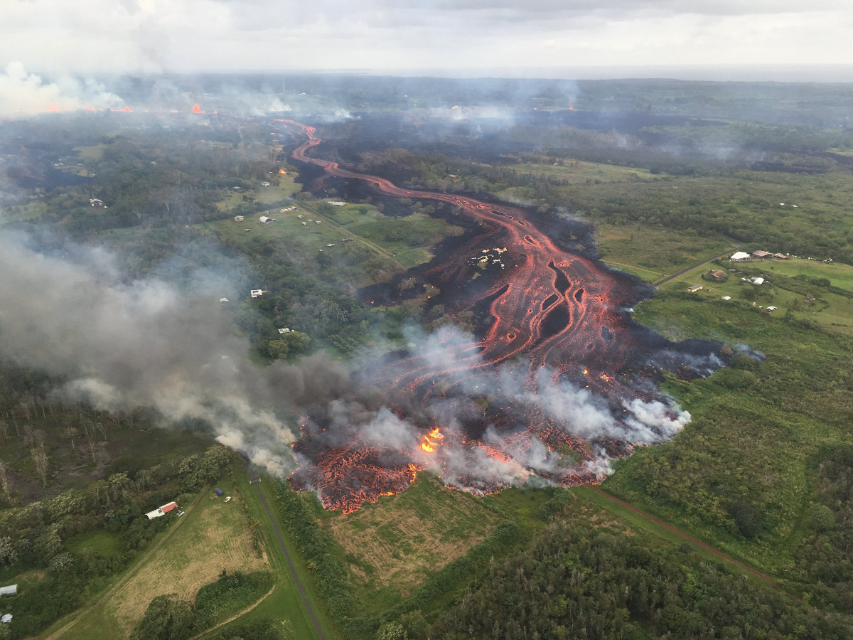
Beginning yesterday and continuing overnight, the rate of lava eruption has increased. Fountaining is occurring at Fissure 17, and Fissures 16-20 have merged into a continuous line of spatter and fountaining. Flows from the consolidated Fissure 20 crossed upper Pohoiki road late yesterday afternoon and continued flowing southward. This morning, the wide flow is very active and is advancing at rates up to 300 yds per hour. A second flow from the same fissure complex is also flowing southward between Pohoiki and Opihikao Rds. The lava flow from Fissure 18 continues to advance more slowly. Fissure 17 and its flow are still active but the flow is advancing even more slowly. It is unknown whether the flows will continue to advance, or stop, and new lava flows are likely given the rate of activity seen at the rift zone.
Additional ground cracking and outbreaks of lava are possible in the area. Residents downslope of the region of fissures should heed all Count of Hawaii Civil Defense messages and warnings.
Magma continues to be supplied to the lower East Rift Zone; however, the GPS instrument near Pu`u Honua`ula is no longer moving suggesting that the rift zone is no longer inflating in this area. Elevated earthquake activity continues, but earthquake locations have not moved farther downrift in the past couple of days.
USGS/HVO continues to monitor the lower East Rift Zone activity 24/7 in coordination with Hawaii County Civil Defense, with geologists onsite to track ongoing and new fissure activity and the advance of lava flows.

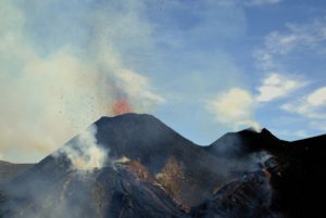
Channelized lava flows originate from a merged elongated fountaining source between fissures 16 and 20 in Kīlauea Volcano’s lower East Rift Zone.
Kīlauea Volcano Summit
An explosion occurred around midnight last night at Halema’uma’u with the plume extending 10,000 ft a.s.l. Moderate trade winds were blowing to the southwest and noticeable ashfall was reported from downwind locations.
Additional explosive events that could produce minor amounts of ashfall downwind are possible at any time. Volcanic gas emissions at the summit remain high.
Saturday, May 19, 2018, 4:13 PM HST (Sunday, May 20, 2018, 02:13 UTC)
Kīlauea Volcano Lower East Rift Zone
Eruption of lava and ground cracking in the area of Leilani Estates subdivision continues.
Beginning yesterday and into today, the rate of lava eruption has increased. Fissure 17 is weakly active now, and Fissures 16-20 have merged into a continuous line of spatter and fountaining. Flows from the consolidated Fissure 20 crossed upper Pohoiki road late yesterday afternoon and continued flowing southward. This afternoon two flows from the merged fissure complex have joined less than a mile from the coast and continue to flow southward between Pohoiki and Opihikao Rds. The lava flow from Fissure 18 is stalled. It is unknown whether the flows will continue to advance, or stop, and new lava flows are likely given the rate of activity seen at the rift zone. Volcanic gas emissions remain very high.

Lava fountains from Fissure 20 in Kīlauea Volcano’s lower East Rift Zone. Photo taken May 19, 2018, at 7:37 AM, HST
Magma continues to be supplied to the lower East Rift Zone; however, a GPS instrument near the Lower East Rift Zone is no longer moving suggesting that the rift zone is no longer inflating in this area. Elevated earthquake activity continues, but earthquake locations have not moved farther downrift in the past couple of days.
USGS/HVO continues to monitor the lower East Rift Zone activity 24/7 in coordination with Hawaii County Civil Defense, with geologists onsite to track ongoing and new fissure activity and the advance of lava flows.
Kīlauea Volcano Summit
Small ash emissions from the Overlook crater have occurred intermittently today. Moderate trade winds were blowing to the southwest and noticeable ashfall may happen in downwind locations.
Additional explosive events that could produce minor amounts of ashfall downwind are possible at any time. Volcanic gas emissions at the summit remain high.
Source : HVO
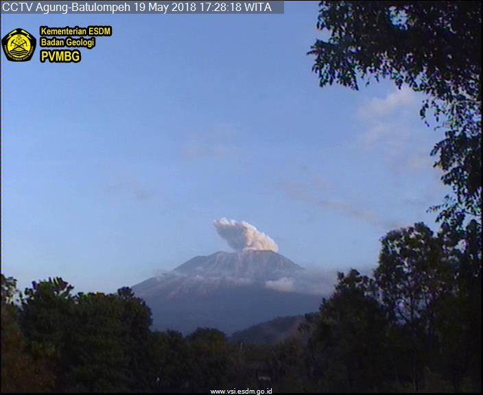
Agung , Indonesia :
VOLCANO OBSERVATORY NOTICE FOR AVIATION – VONA.
Issued: May 19 , 2018.
Volcano: Agung (264020)
Current Aviation Colour Code: ORANGE
Previous Aviation Colour Code: orange
Source: Agung Volcano Observatory
Notice Number: 2018AGU23
Volcano Location: S 08 deg 20 min 31 sec E 115 deg 30 min 29 sec
Area: Bali, Indonesia
Summit Elevation: 10054 FT (3142 M)
Volcanic Activity Summary:
Eruption with volcanic ash cloud at 09:19 UTC (17:19 Local)
Volcanic Cloud Height:
Best estimate of ash-cloud top is around 13254 FT (4142 M) above sea level, may be higher than what can be observed clearly. Source of height data: ground observer.
Other Volcanic Cloud Information:
Ash-cloud is moving southeast
Remarks:
seismic activity is dominated by volcanic earthquake
Source : Magma.
Popocatepetl , Mexico:
May 18, 11:00 am (May 18, 4:00 pm GMT)
During the last 24 hours, through the surveillance systems of the Popocatepetl volcano, 168 low intensity exhalations accompanied by water vapor and gas have been identified. Yesterday, two explosions at 12:50 pm and 14:08 pm have allowed to observe an eruptive column higher than 2 km in height In addition, a volcanotectonic earthquake was recorded yesterday at 16:12 with a magnitude of 1.6 M as well as 55 minutes of high frequency harmonic tremor.
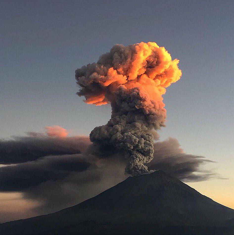
During the night, we observe an incandescence which increases at the time of certain exhalations.
At the time of this report, there is a constant emission of water vapor and gas that the wind disperses to the South.
CENAPRED asked not to approach the volcano and in particular the crater, because of the risk of falling of projectiles and in case of heavy rain to remain far from the bottom of the ravines, because of the danger of landslides and flows of mud.
The volcanic warning light of the Popocatepetl volcano is located at Amarillo Phase 2.
Source : Cenapred
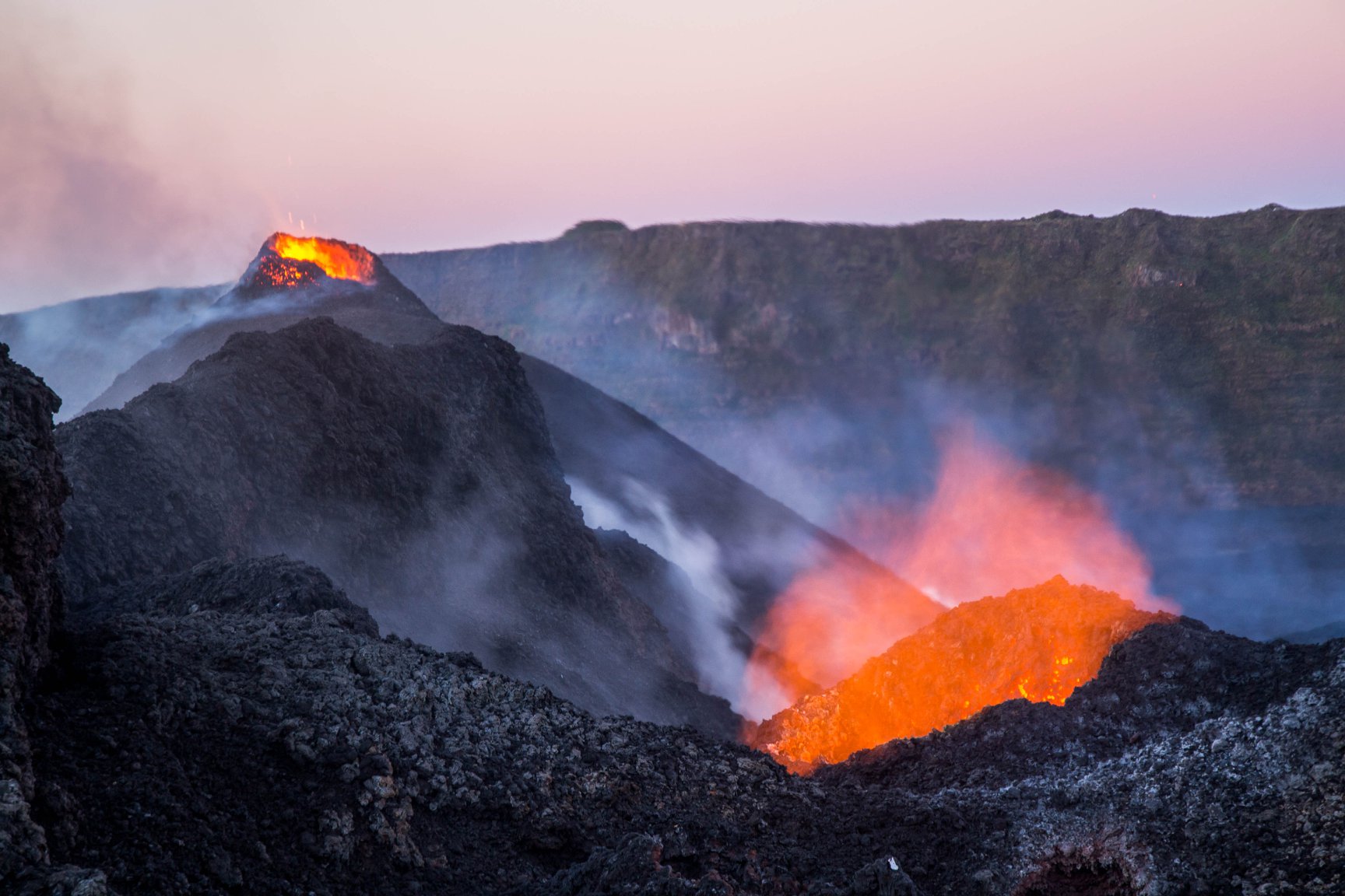
Piton de la Fournaise , La Réunion :
Activity Bulletin from Saturday, May 19, 2018 to 18:00 (local time).
The eruption started on April 27, 2018 at 23:50 local time continues. The intensity of the volcanic tremor (indicator of surface eruptive intensity) has decreased very gradually over the last 48 hours to reach values equivalent to those recorded last Week.
– The flow activity is still predominantly in lava tunnels.
– Observers outside the OVPF reported a significant decrease in the activity observed at the level of the most upstream vent of the crack.
– Surface discharges could not be estimated from satellite data in the last 24 hours due to cloud cover on the volcano.
– The inflation of the building continues.
– No volcano-tectonic earthquake has been recorded during the last 24 hours under the Piton de la Fournaise building.
Alert level: Alert 2-2 – Eruption in the Enclos .
Source : OVPF
Photo : Frederic Leveneur / Fournaise Info.