May 15 , 2018.
Pu’u ‘Ō’ō / Kilauea , Hawai :
Sunday, May 13, 2018, 8:28 PM HST (Monday, May 14, 2018, 06:28 UTC)
Lower East Rift Zone Eruption
Eruption of lava continues from the northeast end of the active fissure system. Residents in lower Puna should remain informed and heed Hawaii County Civil Defense closures, warnings, and messages (http://www.hawaiicounty.gov/active-alerts).
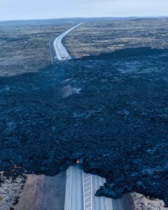
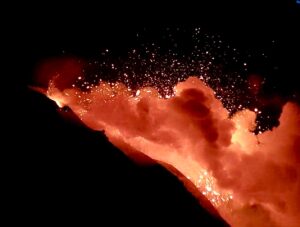
As of late today, activity was dominated by lava fountaining, explosion of spatter bombs hundreds of feet into the air, and several advancing lava flow lobes moving generally northeast from fissure 17 at the downrift (northeast) end of the new fissure system. As of about 7 pm, one lobe was 2 yards thick and advancing roughly parallel to Highway 132. The flow front was just over a half mile southeast of the intersection of Highway 132 and Noni Farms Road.
Based on overflight images late this afternoon, additional lava from fissure 17 was also moving slowly southeast. Volcanic gas emissions remain elevated.
HVO field crews are on site overnight tracking the lava flow as conditions allow and reporting information to Hawaii County Civil Defense.
This eruption is still evolving and additional outbreaks of lava are possible. The location of future outbreaks could include areas both uprift (southwest) and downrift (northeast) of the existing fissures, or, existing fissures can be reactivated. Communities downslope of these fissures could be at risk from lava inundation. Activity can change rapidly.
After a night of lava fountaining, fissure 17 continues to be active. This morning, Hawaii County Civil Defense says a “narrow lava flow has been generated and is slowly moving toward the ocean, which is about two miles away.”
There are no homes or roads threatened at this time, civil defense says.
Puna residents heard the explosions for miles around the fissure Sunday night, as spatter bombs were launched hundreds of feet into the air. Scientists with the USGS Hawaiian Volcano Observatory last night reported several advancing lava flow lobes moving generally northeast from fissure 17 at the northeast end, or downrift, of the new fissure system.
As of about 7 pm, one lobe was 2 yards thick and advancing roughly parallel to Highway 132. The flow front was just over a half mile southeast of the intersection of Highway 132 and Noni Farms Road, scientists reported.
Kīlauea Volcano Summit
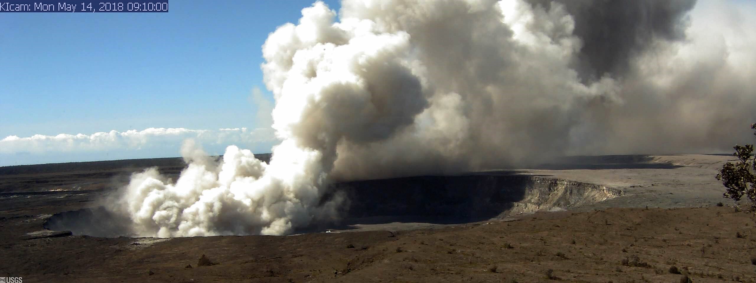
Deflationary tilt continues. A robust plume of steam and volcanic gas, occasionally mixed with ash, has risen from the Overlook crater within Halemaumau. Over the course of the day, rockfalls from the steep walls enclosing the Overlook crater generated ash clouds mixed with steam and gas intermittently throughout the day. These ash clouds have been relatively low concentration and have risen at most only a few thousand feet above the ground, a few generating very localized ashfall downwind. More explosive activity generating larger ash clouds remains possible and can occur with no warning.
Earthquake activity in the summit remains elevated with several strongly felt events at HVO today. Most of these earthquakes are related to the ongoing subsidence of the summit area and earthquakes beneath the south flank of the volcano.
Monday, May 14, 2018, 8:36 AM HST (Monday, May 14, 2018, 18:36 UTC)
Summary:
LOWER EAST RIFT ZONE
Eruption of lava continues from multiple points along the northeast end of the active fissure system. Residents in lower Puna should remain informed and heed Hawaii County Civil Defense closures, warnings, and messages (http://www.hawaiicounty.gov/active-alerts)
This morning, activity is dominated by lava fountaining, explosion of spatter more than 100 feet into the air, and an advancing lava flow from fissure 17 at the northeast end of the fissure system. As of 630 am the fissure 17 flow had traveled just under a mile roughly east-southeast parallel to the rift zone. It is turning slightly south and at this time is about one half mile south of Highway 132.
Fissure 18 that became active late yesterday is weakly active.

Continued eruptive activity at fissure #17 fed a 1.5 mile long ʻaʻā flow to within 150 yards of Hwy 132, and a mile of Hwy 137 (Red Road). Several homes in the immediate vicinity are threatened, and so are the two major thoroughfares. The tradewinds are blowing the eruptionʻs toxic emissions down the coast, toward Opihikao and Kalapana.
A fissure 19 has been spotted very near fissure 15 as of about 8 am just northeast of Pohoiki Road and north of Hinalo Street at the east end of Lanipuna Gardens. It is producing a sluggish lava flow.
Volcanic gas emissions remain elevated throughout the area downwind of the vents. Yesterday with the onset of activity at fissure 17, powerful steam jets have occurred intermittently near the west end of the fissure. These jets may be responsible for some of the loud sounds reported by residents and emergency workers.
HVO field crews are on site tracking the lava flow as conditions allow and reporting information to Hawaii County Civil Defense.
This eruption is still evolving and additional outbreaks of lava are possible. Ground deformation continues and seismicity remains elevated in the area.

This 100 yard long string of low fountaining feeds a massive ʻaʻā flow that threatens several homes and the two major means of egress for residents and visitors in the area, Highways 132 and 137.
The location of future outbreaks could include areas both uprift (southwest) and downrift (northeast) of the existing fissures, or, existing fissures can be reactivated. Communities downslope of these fissures could be at risk from lava inundation. Activity can change rapidly.
Conditions around the erupting fissures can change very quickly. Residents in lower Puna should remain informed and heed Hawaii County Civil Defense closures, warnings, and messages (http://www.hawaiicounty.gov/active-alerts).
KILAUEA SUMMIT
Deflationary tilt at the summit of the volcano continues and seismicity remains elevated. Last night several strong earthquakes shook HVO and the surrounding area.
This morning, a steady, vigorous plume of steam and occasionally minor amounts of ash is rising from the Overlook vent and drifting downwind to the southwest. As has been observed over the past several days, occasional rockfalls into the deep vent are expected produce intermittent pulses of slightly more vigorous ash emissions. Depending on wind conditions, dustings of ash may occur in the Kilauea summit area and downwind. More energetic ash emissions are possible if explosive activity commences.
Source : HVO
Photos et videos : USGS / HVO , Bruce Omori ,
Shinmoedake , Japan :
Mt. Shimmoe on the southwestern Japan main island of Kyushu erupted again Monday, prompting the weather agency to warn of falling ash and flying rocks in nearby areas.
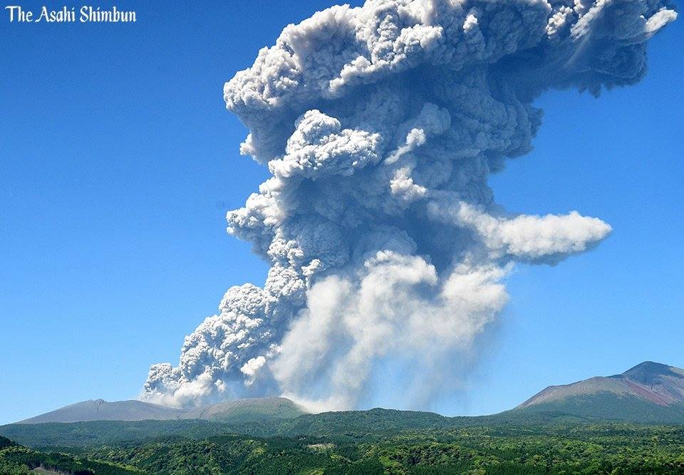
The 1,421-meter high volcano straddling Kagoshima and Miyazaki prefectures erupted at around 2:45 p.m., with volcanic smoke rising up to 3,300 meters in the air, according to the Japan Meteorological Agency. The volcano last erupted on April 6.
The agency maintained a level 3 alert on a scale of 5, warning people not to approach the volcano. It also warned of large flying rocks in areas 3 kilometers from the crater.
Source : english.kyodonews.net .
Photo : Asahi Simbun
Dukono , Indonesia :
VOLCANO OBSERVATORY NOTICE FOR AVIATION – VONA.
Issued: May 12 , 2018.
Volcano: Dukono (268010)
Current Aviation Colour Code: ORANGE
Previous Aviation Colour Code: orange
Source: Dukono Volcano Observatory
Notice Number: 2018DUK67
Volcano Location: N 01 deg 41 min 35 sec E 127 deg 53 min 38 sec
Area: North Maluku, Indonesia
Summit Elevation: 3933 FT (1229 M)
Volcanic Activity Summary:
Eruption with volcanic ash cloud at 21h49 UTC (06h49 local). May 12 , 2018.
Volcanic Cloud Height:
Best estimate of ash-cloud top is around 6173 FT (1929 M) above sea level, may be higher than what can be observed clearly. Source of height data: ground observer.
Other Volcanic Cloud Information:
Ash cloud moving to east.
Remarks:
Eruption and ash emission is continuing.
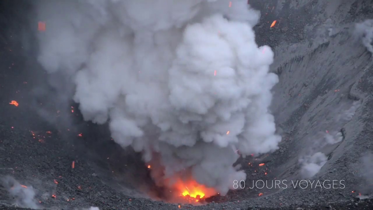
Level II Activity Level (WASPADA). The Dukono (1229 m above sea level) has a continuous eruption.
Since yesterday until this morning, the visual volcano can be observed clearly until it is covered with fog. Smoke from the crater and eruptive ash are observed up to 700-900 m above the peak. . Three eruptions were observed with a column of smoke rising from 700 to 900 m above the peak, white and gray in color. The wind is blowing weakly to moderately to the east.
According to the seismographs dated May 13, 2018, it was recorded:
3 earthquakes of eruption.
1 tectonic earthquake
Tremor continuous (microtremor) with a maximum amplitude of 0.5-10 mm (dominant 2 mm)
Recommendations:
Communities around G. Dukono and visitors / tourists should avoid activities, climbing and approaching the Malupang Warirang Crater within a radius of 2 km.
Source : Magma , VSI.
Photo : S Chermette / 80 jours voyage.
Piton de la Fournaise , La Réunion :
Activity Bulletin Monday, May 14, 2018 at 16:00 (local time)
The eruption started on April 27, 2018 at 23:50 local time continues. The intensity of the volcanic tremor (indicator of surface eruptive intensity) has remained relatively stable over the last 24 hours.
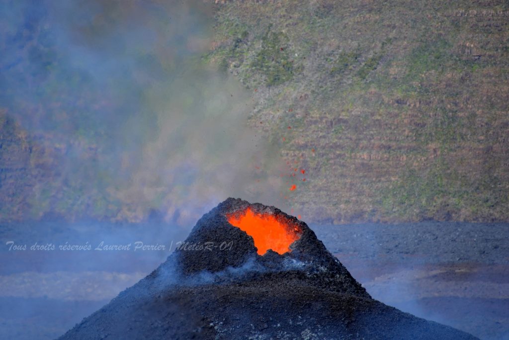
– The activity now taking place mainly in lava tunnels, the surface flows could not be estimated today from the satellite data.
The CO2 concentrations in the air at the top and the CO2 concentrations in the soil in the Plains region remain high.
– The inflation (swelling) of the building seems to resume. This parameter will be confirmed in the coming days.
– No volcano-tectonic earthquake has been recorded during the last 24 hours under the Piton de la Fournaise building.
Alert level: Alert 2-2 – Eruption in the Enclos .
Source : OVPF
Photo : Laurent Perrier / objectif volcan
Poas / Turrialba , Costa Rica :
Poas and Turrialba Volcano Activity Report, May 13, 2018, update at 10:40 am
Poás Volcano:
During the past 24 hours, seismographs have recorded signals of low seismic activity. The Poás volcano has a persistent but weak degassing of water vapor, aerosols and gases. When it is possible to observe it, the vapor plume rises between 200 and 500 meters from the bottom of the crater.
The direction of the prevailing winds is oriented towards the southwest; these winds have variable speeds between 6.3 km / h (current speed) up to 31.2 km / h; data provided by the IMN weather station.
Yesterday, there was no perception of the smell of sulfur or ash falling.
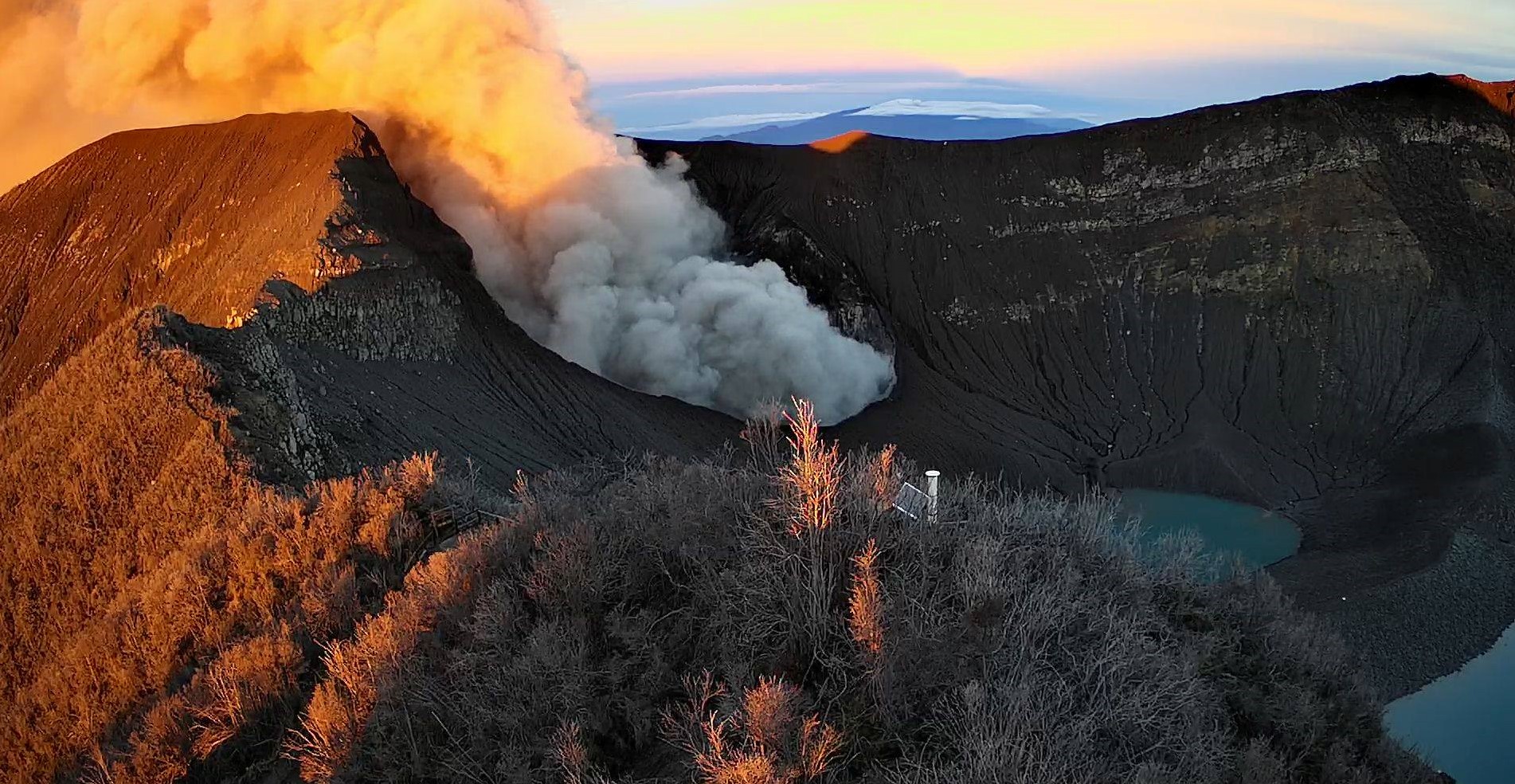
Turrialba volcano: (photo).
During the last 24 hours, the activity of the Turrialba volcano has maintained a continuous tremor of low amplitude as observed in the VTun station.
Turrialba has periods of non-continuous degassing of time. It was observed at 9:20 pm today a weak plume of steam and gas that rose 300 to 500 meters above the summit.
The direction of the prevailing winds is oriented towards the southwest; these winds have variable speeds ranging from 4.1 km / h (current speed) to 27.9 km / h; data provided by the IMN weather station.
Yesterday and until that moment there is no report of falling ashes.
Source : Ovsicori