March 02 , 2018.
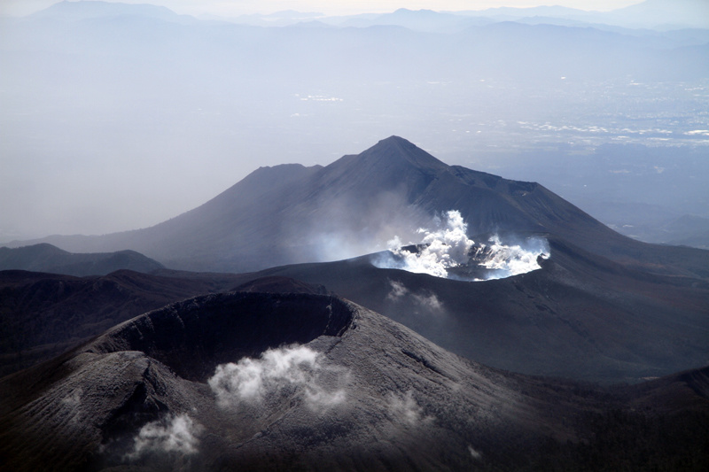
Piton de la Fournaise , La Réunion :
Monthly bulletin of thursday, march 1st, 2018.
Seismicity:
In February 2018, the OVPF recorded in total:
• 68 superficial volcano-tectonic earthquakes (0 to 2 km deep) beneath the summit craters;
• 3 deep earthquakes (> 2 km deep);
• 168 collapses (in the Dolomieu crater, at the Enclos Fouqué ramparts and at the eruptive site of July / August 2017);
• 60 local earthquakes (under the island, Piton des Neiges side);
• 2 regional earthquakes (in the Indian Ocean zone).
Volcano-tectonic activity under the Piton de la Fournaise massif increased slightly during the last two weeks of February, with 63 events recorded between February 16 and 28 (Figure 1).
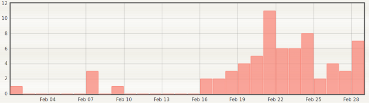
Figure 1: Histogram showing the number of superficial volcano-tectonic earthquakes recorded under the summit craters between January 1 and February 28, 2018. (© OVPF / IPGP)
Deformation.
Following the significant inflation in January linked to intense hydrothermal activity, a consequence of the heavy rains of the beginning of the year (02 to 18 January 2018, see the monthly bulletin of 01 February 2018), a relaxation and a deflation of the peak area was observed until about 10 February. Inflation (swelling) of the building has since been recorded again (Figure 2).
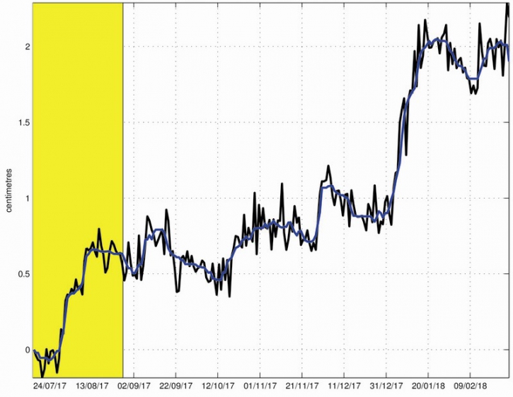
Figure 2: Illustration of the deformation since the end of the eruption of July 14-August 28, 2017 (the eruption of July 14-August 28, 2017 is here shown in yellow). Here is shown a baseline (distance between two GPS receivers) crossing the Dolomieu crater from north to south (in black the raw data, in blue the data smoothed over a week). A rise is synonymous with elongation and therefore swelling of the volcano; conversely, a decrease is synonymous with contraction and therefore deflation of the volcano. (© OVPF / IPGP)
Geochemistry of gases.
The increase in seismicity during the last two weeks of February and the resumption of inflation in the summit zone were accompanied by variations in the CO2 concentrations recorded in the soil:
– Distal sector, region Plaine des Cafres / Plains of Palmistes: Downward trend.
– Area close to the Volcano Lodge: Strong increase (Figure 3).
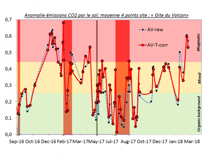
Figure 3: Average CO2 concentration in soil at the Volcano Lodge between September 2016 and February 2018 (the eruptions of 11-18 September 2016, 31 January-27 February 2017 and 14 July – 28 August 2017 are represented in red, and the injection of magma of May 17, 2017 is represented by a gray bar). In blue the raw data. In red the corrected data of temperature effects. Values are normalized to the maximum value recorded. (© OVPF / IPGP)
The decrease in CO2 concentrations in the far-field soil associated with an increase in fields near the terminal cone could indicate a transfer of the distant zones to the central zone (in line with the increase in peak inflation at the end of February).
It should be noted that the SO2 fluxes in the air recorded at the edge of the Enclos Fouqué are below or close to the detection threshold (the absence of detection is compatible with a magmatic transfer which remains always deep, below the level of the sea).
At the top, low concentrations of H2S (near the limit of detection) and sometimes of SO2 are always recorded.

Balance sheet of the Piton de la Fournaise activity:
All these observations show for the month of February the continuation of:
– a deep re-feeding of magma (below sea level);
– a pressurization of the superficial magmatic reservoir which tends to accelerate.
Source : OVPF.
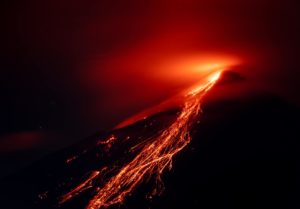
Mayon , Philippines :
MAYON VOLCANO BULLETIN 02 March 2018 08:00 A.M.
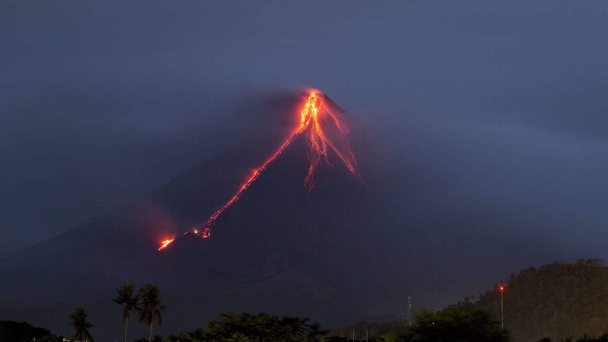
Mayon’s activity in the past 24 hours was characterized by general quiescence, gravity-driven lava flow and degassing from the summit crater. Three (3) events between 7:11 AM and 1:41 PM that lasted one (1) to two (2) minutes generated ash plumes that rose 600 meters above the summit crater before drifting southwest. At night, lava flows were observed to continue moving downslope within 3.3 kilometers, 4.5 kilometers and 900 meters from the crater on the Miisi, Bonga and Basud Gullies, respectively.
A total of fifty-three (53) volcanic earthquakes and four (4) rockfall events were recorded by Mayon’s seismic monitoring network. Sulfur dioxide (SO2) emission was measured at an average of 1,533 tonnes/day on 28 February 2018. Deflation of the lower slopes that began on 20 February is still being recorded by electronic tilt. Nonetheless, overall electronic tilt and continuous GPS data indicate that the edifice is still swollen or inflated relative to November and October 2017, consistent with campaign Precise Leveling data acquired last week.
Alert Level 4 still remains in effect over Mayon Volcano. The public is strongly advised to be vigilant and desist from entering the eight (8) kilometer-radius danger zone, and to be additionally vigilant against pyroclastic density currents, lahars and sediment-laden stream flows along channels draining the edifice. Civil aviation authorities must also advise pilots to avoid flying close to the volcano’s summit as ash from any sudden eruption can be hazardous to aircraft.
DOST-PHIVOLCS maintains close monitoring of Mayon Volcano and any new development will be communicated to all concerned stakeholders.
Source : Phivolcs
Photo : Earl Recamunda
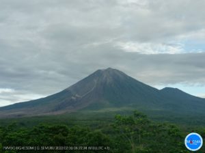
Shinmoedake , Japan :
Mount Shinmoe in southwest Japan appears to erupt.
Japan’s Meteorological Agency says a volcano in the country’s southwest appears to have erupted.
The agency says volcanic tremors began on Mount Shinmoe in the Kirishima mountain range, bordering Kagoshima and Miyazaki prefectures, at around 8:15 AM Thursday, Japan time.
Volcanic ash was reported falling at the foot of the mountain at around 11:00 AM. Shinmoe last erupted in October.
The agency plans to keep the alert level at 3 on a scale of 5. It is urging caution for volcanic rocks within about 2 kilometers from the crater, and for pyroclastic flows within 1 kilometer.
Source : 3.nhk.or.jp
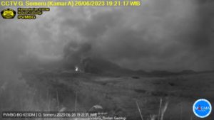
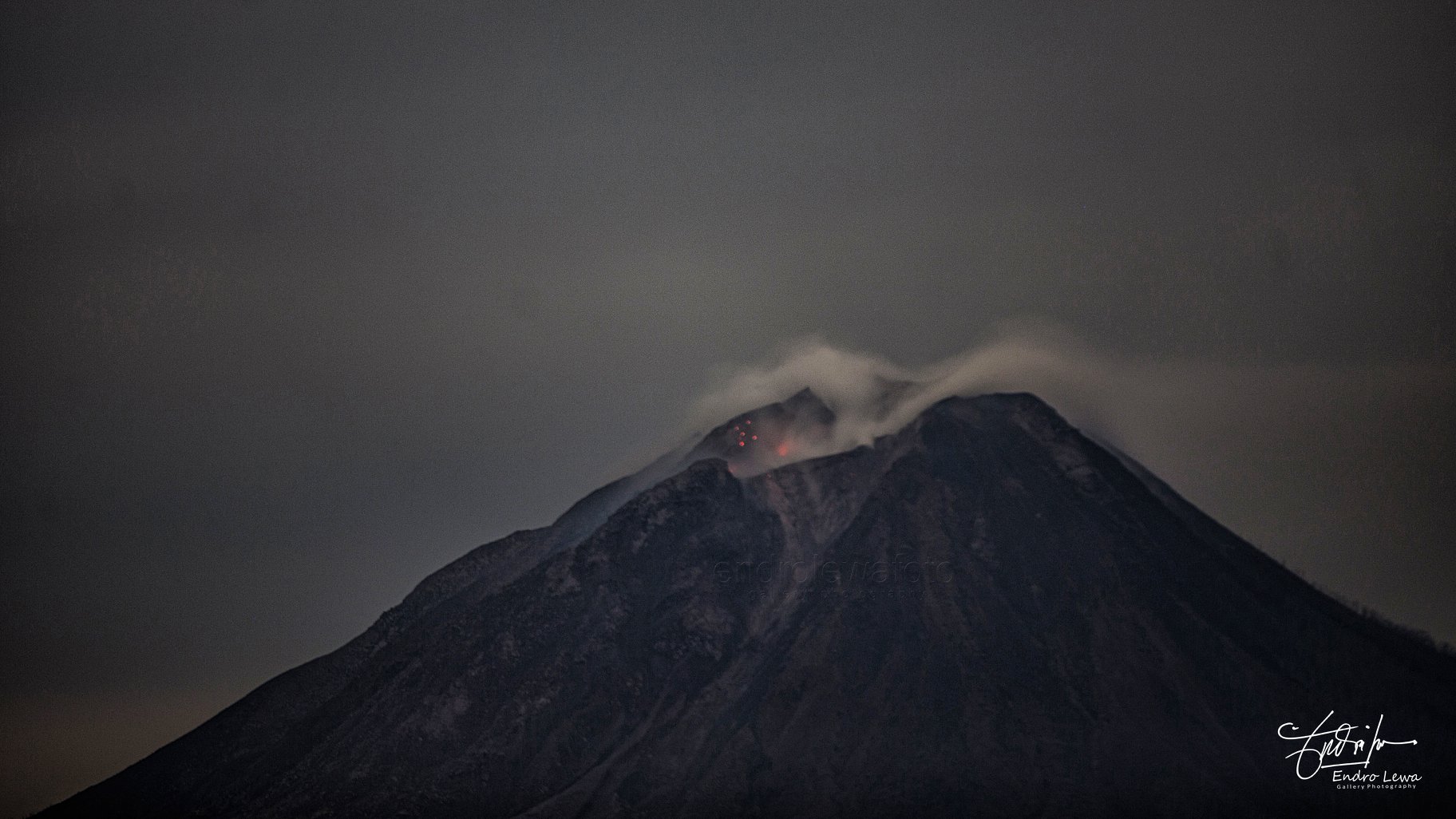
Sinabung , Indonesia :
Activity Level at Level IV (AWAS). The Sinabung (2460 m altitude) has been erupting constantly since 2013.
Since yesterday until this morning the volcano has been observed until it is covered with fog. The smoke coming out of the crater could be observed as white / gray, with a height of 100 to 300 m above the summit. Surface activity was not accompanied by eruption. The wind is blowing weakly to moderately to the west and north.
According to the seismographs , on 01 March 2018, it has been recorded:
1 earthquake type « Tornillo »
4 earthquakes of emission.
3 distant tectonic earthquakes.
7 low frequency earthquakes
1 phase / hybrid earthquake
12 shallow volcanic earthquake (VB)
151 deep volcanic earthquakes (VA)
2 local tectonic earthquakes (felt)
Since yesterday until now there have been two lava collapse events recorded for 40 minutes and 34 minutes.
Recommendations:
Communities / visitors should not do activities within 3 km of the summit, and by sector, 7 km to the South-South-East, 6 km East-South-East and 4 km to the South-East. km northeast.
The deposits formed a dam upstream on the Laborus River. People living in downstream river basins and around the Laborus River need to be vigilant because these dams can collapse at any time and no longer retain water volume, resulting in downstream lahars / floods .
Source : VSI
Photo : Endro Lewa
California Volcanoes , United States :
Current Volcano Alert Level: all NORMAL
Current Aviation Color Code: all GREEN
Activity Update:
All volcanoes monitored by CalVO using telemetered, real-time sensor networks exhibit normal levels of background seismicity and deformation. Volcanoes monitored include Mount Shasta, Medicine Lake Volcano, Clear Lake Volcanic Field, Lassen Volcanic Center, Long Valley Volcanic Region, Coso Volcanic Field, Ubehebe Craters, and Salton Buttes.
Observations for February 1, 2018 (0000h PST) through February 28, 2018 (2359h PDT):
Mt Shasta: Three earthquakes of M1.0 or greater were detected, with the largest event registering M1.49.
Medicine Lake: No earthquakes of M1.0 or greater were detected.
Lassen Volcanic Center: Thirty-six earthquakes of M1.0 or greater were detected, with the largest event registering M2.87. Many of these events occurred during two minor seismic swarms on February 17 and 19-20, 2018 near the Shasta, Tehama and Plumas county lines and about 8 miles northeast of the town of Mineral.
Clear Lake Volcanic Field: No earthquakes of M1.0 or greater were detected. [Note: The typical high level of seismicity was observed under the Geysers steam field located at the western margin of CLVF. The largest event was M3.23].
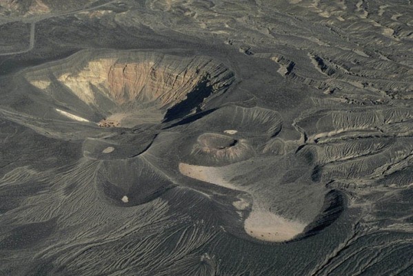
Ubehebe
Long Valley Volcanic Region: In Long Valley Caldera, 35 earthquakes of M1.0 or greater were detected, with the largest event registering M2.20. Ten earthquakes of M1.0 or greater were detected in the Mono Craters region. The largest registered M2.49. One earthquake of M1.0 or greater was detected under Mammoth Mountain (M1.52). [Note: The typical high level of seismicity was observed south of the caldera in the Sierra Nevada range. The largest event registered M2.40].
Ubehebe Craters: No earthquakes at or above M1.0 were detected.
Salton Buttes: Ten earthquakes of M1.0 or greater were detected, with the largest registering M2.47.
Coso Volcanic Field: Seventeen earthquakes of M1.0 or greater were detected, with the largest registering M2.15.
The U.S. Geological Survey will continue to monitor these volcanoes closely and will issue additional updates and changes in alert level as warranted.
Source : CalVO