October 2 , 2025.
Hawaii , Kilauea :
HAWAIIAN VOLCANO OBSERVATORY STATUS REPORT , U.S. Geological Survey
Wednesday, October 1, 2025, 12:30 AM HST (Wednesday, October 1, 2025, 10:30 UTC)
19°25’16 » N 155°17’13 » W,
Summit Elevation 4091 ft (1247 m)
Current Volcano Alert Level: WATCH
Current Aviation Color Code: ORANGE
Activity Summary:
The onset of episode 34 sustained fountaining is likely in the next few hours to a day if Kīlauea continues to inflate and continuous overflows are sustained.
Continuous precursory low-level activity preceding episode 34 of the ongoing Halemaʻumaʻu eruption started with a short overflow from 11:43 p.m. HST on September 30, accompanied by small fountains up to around 10 meters (30 feet) in height. These precursory overflows are expected to continue and indicate that degassed magma is being pushed from the vent. The low-level precursory activity should increase and transition to sustained voluminous fountains of episode 34 within a few hours to a day.
Over 100 intermittent overflows from the north vent have occurred since around 9:43 p.m. HST on September 27.
Issued: Wednesday, October 1, 2025, 1:13 AM HST
Volcanic Activity Summary:
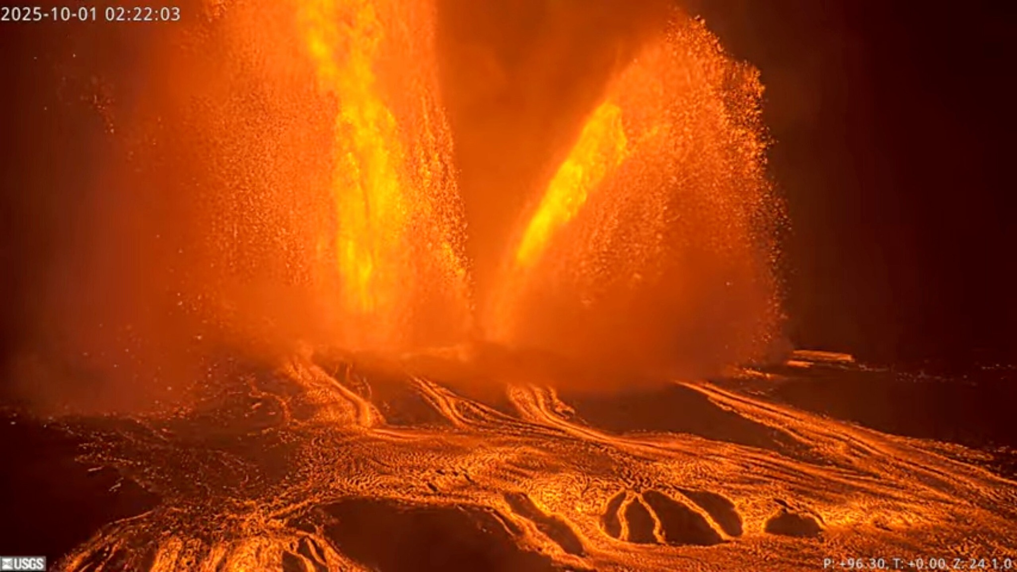
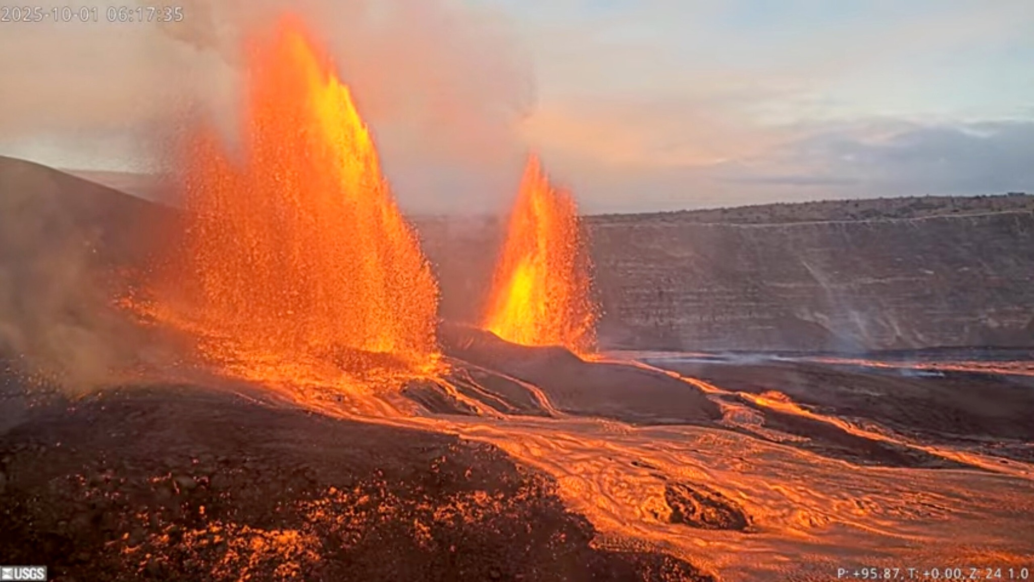
Episode 34 of the ongoing Halemaʻumaʻu eruption began at 12:53 a.m. HST on October 1. Low lava fountains, approximately 30 feet (10 meters) high began feeding lava flows from the north vent at 11:43 p.m. HST on September 30. Fountains began to increase in size and volume along with the onset of deflation at 12:53 a.m. HST October 1. Fountains are currently up to 330 feet or 100 meters and inclined slightly to the northeast. Past episodes have produced incandescent lava fountains over 1000 feet (300 meters) high with eruptive plumes up to 20,000 feet (6000 meters) above ground level. According to the National Park Service and the USGS SDH monitoring station, winds are blowing moderately from the northeast direction, which suggests that volcanic gas emissions and volcanic material may be distributed to the southwest of Halemaʻumaʻu.
All eruptive activity is confined to Halemaʻumaʻu crater within Hawaiʻi Volcanoes National Park; commercial airports in Hawaii County (KOA and ITO) will not be affected by this activity.
Episode 34 was preceded by over 120 gas pistoning events producing small, sporadic spatter fountains 10 feet (3 meters) and many resulting in short overflows. These events began at approximately 9:47 p.m. September 28 and continued to increase in frequency and intensity until they became rhythmic at 1:30 p.m., September 29. The rhythmic gas pistons continued past midnight, but produced only 10 overflows in 100 events by 6:30 a.m. HST. Gas pistoning continued and magma remained high in the north vent, and additional overflows occurred from 2:22 p.m. to 6:50 p.m. HST on September 30. Sustained overflow and low-level fountaining began at 11:43 p.m. HST on September 30 with 30 foot (10 meter) fountains. Fountaining became began increasing in height to over 60 feet (20 meters) and ground deformation of Kīlauea summit switched from inflation to deflation at approximately 12:53 a.m. HST on October 1, indicating the episode 34 has begun.
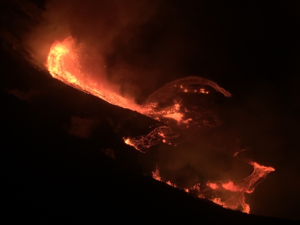
Fountains from the north vent are currently up to 330 feet or 100 meters and inclined slightly to the northeast, feeding lava flows within Halemaʻumaʻu crater.
Inflationary tilt reached 18 microradians since the end of the last episode. Seismic tremor began increasing and tilt at UWD switched from inflationary to deflationary at about 12:53 a.m. HST.
Wednesday, October 1, 2025, 9:46 AM HST (Wednesday, October 1, 2025, 19:46 UTC)
Summit Observations:
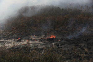
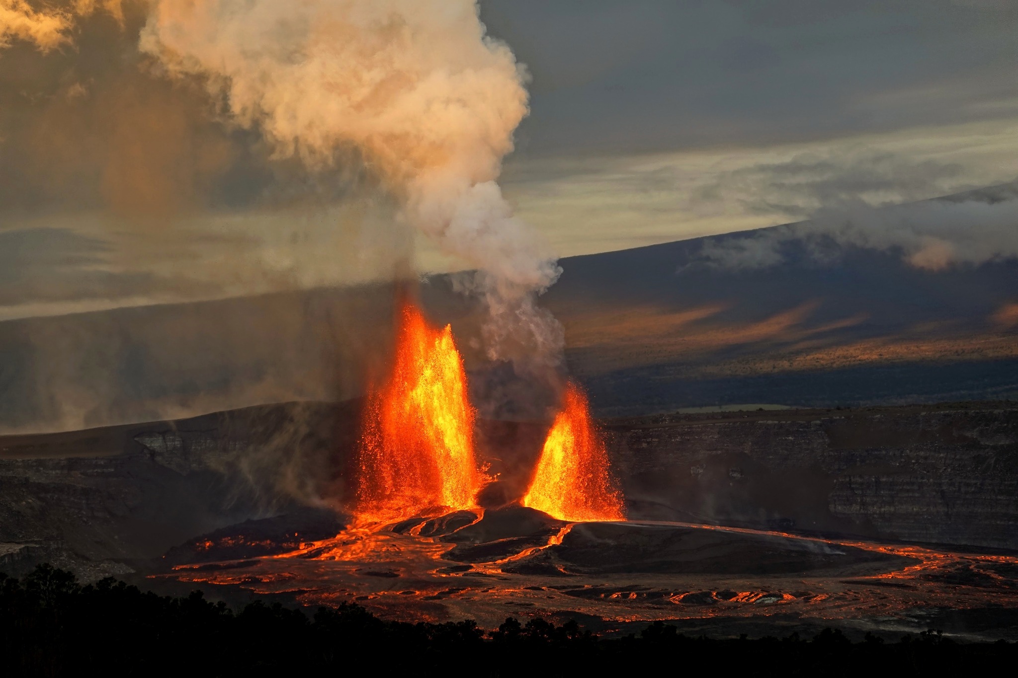
Lava fountains from the north vent increased in vigor quickly, reaching up to 330 feet or 100 meters and were inclined slightly to the northeast. At 1:45 a.m. HST on October 1, the south vent began erupting and became the dominant fountain as the episode progressed, reaching vertically up to an estimated 1300 ft (400 m). Fountaining from both vents persisted for just over 6 hours but gradually declined in height. The two vents generated lava flows that covered a large portion of the western part of Halemaʻumaʻu crater floor with channelized lava flows. The south vent stopped erupting at approximately 7:00 a.m. and the north vent followed shortly after at 7:03 a.m. HST, marking the end of episode 34.
Deflationary tilt at UWD totaled approximately 26 microradians during the fountaining, with an estimated volume of approximately 12 million cubic yards (9 million cubic meters or 2.5 billion gallons) of lava erupted overnight. The dual fountains also produced a record combined effusion of 500 cubic yards per second, about twice the maximum eruptive rate measured in previous episodes. After eruptive activity ceased at 7:03 a.m. HST, the caldera this morning has been quiet with a passive outgassing plume rising from the vents. Scattered incandescence on the lava flow field, due to residual heat, may continue in the coming days as these recently erupted deposits cool over time. Currently the UWD tiltmeter shows that inflationary tilt has resumed since the end of episode 34, with less than a microradian recorded so far.
Source : HVO.
Photos : USGS , Volcano Hideaways
United – States , Yellowstone :
YELLOWSTONE VOLCANO OBSERVATORY MONTHLY UPDATE , U.S. Geological Survey
Wednesday, October 1, 2025, 12:49 PM MDT (Wednesday, October 1, 2025, 18:49 UTC)
44°25’48 » N 110°40’12 » W,
Summit Elevation 9203 ft (2805 m)
Current Volcano Alert Level: NORMAL
Current Aviation Color Code: GREEN
Summary
Yellowstone Caldera activity remains at background levels, with 87 located earthquakes in September (largest = M3.3). Deformation measurements indicate that the annual summertime pause in long-term caldera subsidence started in late May.
Recent Work and News
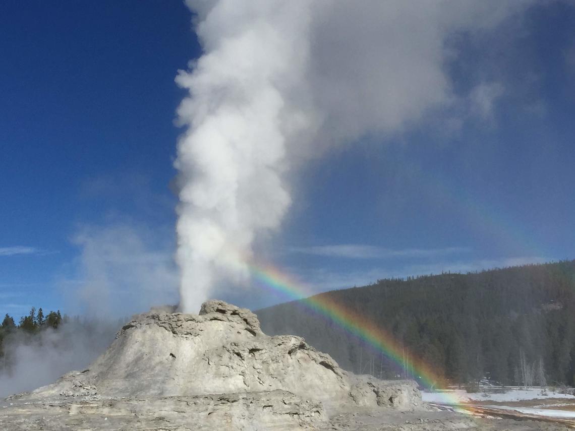
Minor eruptions of Steamboat Geyser in Norris Geyser Basin remain sporadic, indicating that a major eruption is unlikely anytime soon. There have only been 2 major eruptions of the geyser so far during 2025, and the period of frequent activity that started in 2018 is probably ending. Valentine and Guardian Geysers in Norris Geyser Basin have been erupting intermittently since August, the former for the first time in more than 20 years. In late September a new steam vent opened in the Mud Volcano area in a location of numerous past venting episodes.
During the past month, field engineers from EarthScope Consortium performed maintenance and upgrades on several continuous GPS stations in the park. USGS staff recovered temporary GPS deployments and swapped batteries at temperature monitoring stations, and they also conducted a microgravity survey in the Norris, Old Faithful, and Hayden Valley areas.
Seismicity
During September 2025, the University of Utah Seismograph Stations, responsible for the operation and analysis of the Yellowstone Seismic Network, located 87 earthquakes in the Yellowstone National Park region. The largest event of the month was a minor earthquake of magnitude 3.3 located about 14 miles south-southwest of Mammoth Hot Springs in Yellowstone National Park on September 28 at 1:29 a.m. MDT.
September seismicity in Yellowstone was marked by one swarm of 16 earthquakes that occurred approximately 14 miles south-southwest of Mammoth Hot Springs during September 27–29. The swarm was a culmination of mild ongoing seismicity in the area throughout September. The largest swarm event is also the largest event in September, described above.
Yellowstone earthquake activity remains at background levels.
Ground Deformation
Continuous GPS stations in Yellowstone Caldera continue to record the annual summertime pause in subsidence or transition to slight uplift, which is caused by seasonal changes related to snowmelt and groundwater conditions. Since late May, the caldera has risen by about 1.5 cm (roughly half an inch), which is superimposed on the overall trend of subsidence that has been ongoing since 2015–2016. Deformation in the area of Norris Geyser Basin also recorded the seasonal uplift, but with no overall changes during the past several years.
Source : YVO
Photo : Shaul Hurwitz USGS
Japan , Suwanosejima :
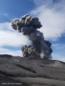
The Japan Meteorological Agency (JMA) reported that eruptive activity at Suwanosejima’s Ontake Crater continued during 22-29 September. Incandescence was observed nightly in webcam images. Eruptive events during 23-28 September generated ash plumes that rose 1-1.6 km above the crater rim and drifted mainly N, NW, and E. Small amounts of ashfall were reported in Toshima Village (3.5 km SSW) on 27 September. Ash emissions were continuous from 22h38 on 27 September to 01h00 on 28 September. The Alert Level remained at 2 (the second level on a five-level scale) and the public was warned to be cautious within 1.5 km of the crater.
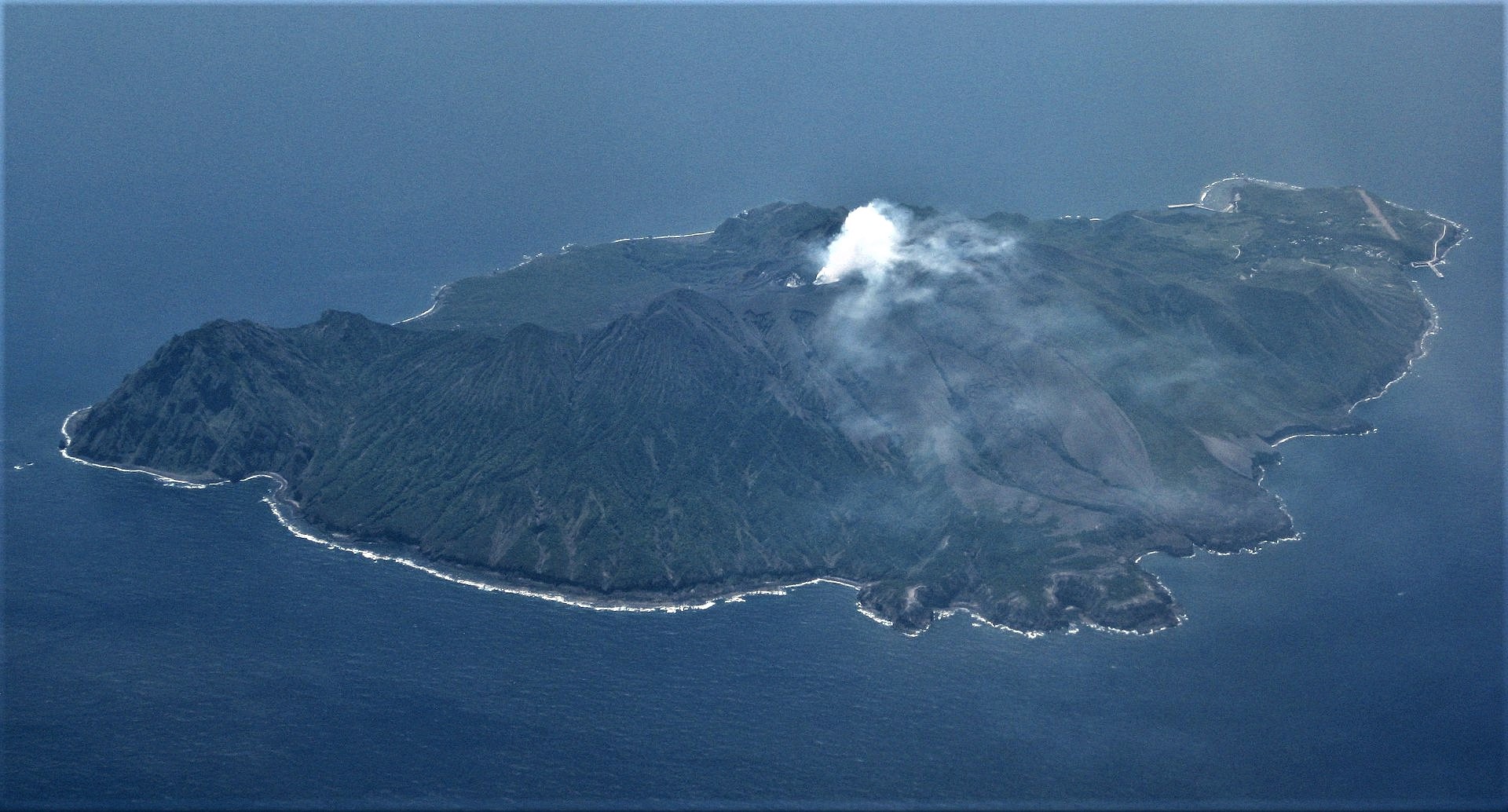
The 8-km-long island of Suwanosejima in the northern Ryukyu Islands consists of an andesitic stratovolcano with two active summit craters. The summit is truncated by a large breached crater extending to the sea on the E flank that was formed by edifice collapse. One of Japan’s most frequently active volcanoes, it was in a state of intermittent Strombolian activity from Otake, the NE summit crater, between 1949 and 1996, after which periods of inactivity lengthened. The largest recorded eruption took place in 1813-14, when thick scoria deposits covered residential areas, and the SW crater produced two lava flows that reached the western coast. At the end of the eruption the summit of Otake collapsed, forming a large debris avalanche and creating an open collapse scarp extending to the eastern coast. The island remained uninhabited for about 70 years after the 1813-1814 eruption. Lava flows reached the eastern coast of the island in 1884. Only about 50 people live on the island.
Sources: Japan Meteorological Agency (JMA) , GVP.
Photo : Ray Go.
Chile , Puyehue-Cordon Caulle :
Special Volcanic Activity Report (REAV), Los Lagos region, Puyehue-Cordon Caulle volcanic complex, October 1, 2025, 5:15 a.m. local time (mainland Chile).
The National Geology and Mining Service of Chile (SERNAGEOMIN) publishes the following preliminary information, obtained using the monitoring equipment of the National Volcanic Monitoring Network (RNVV), processed and analyzed at the Southern Andean Volcanological Observatory (OVDAS):
On Wednesday, October 1, 2025, at 4:49 a.m. local time (07:49 UTC), monitoring stations installed near the Puyehue-Cordon Caulle volcanic complex recorded an earthquake associated with rock fracturing (volcano-tectonic type).
The characteristics of the earthquakes after their analysis are as follows:
TIME OF ORIGIN: 04:49 local time (07:49 UTC)
LATITUDE: 40.560° S
LONGITUDE: 72.159° W
DEPTH: 4.9 km
LOCAL MAGNITUDE: 3.1 (ML)
OBSERVATIONS:
At the time of this report, no changes in the monitored parameters or earthquakes of similar characteristics have been recorded.
The Volcanic Technical Alert remains at YELLOW.
Source : Sernageomin
Photo : Wikipedia
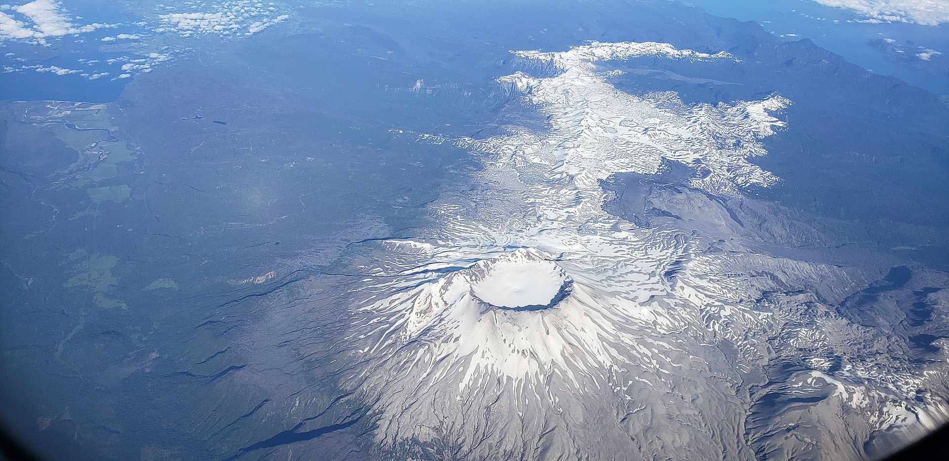
Colombia , Puracé – Chaîne volcanique Los Coconucos :
Popayán, September 30, 2025, 3:00 p.m.
Regarding the monitoring of the activity of the Puracé Volcano – Los Coconucos Volcanic Range, the Colombian Geological Survey (SGC), an entity affiliated with the Ministry of Mines and Energy, reports that:
During the week of September 23-29, 2025, a signal classified as continuous volcanic tremor continued to be persistently recorded. This signal is associated with fluid dynamics in volcanic conduits. Although generally considered low-energy, it was associated, on the 29th, with increased degassing from the Puracé Volcano crater. The earthquakes related to fluid movement were characterized by low-energy input and occurred mainly beneath the western flank of the Puracé Volcano crater, at a depth of less than 1 km. Compared to previous weeks, fracture earthquakes remained stable in terms of the number of events and were located mainly between the Puracé and Piocollo volcanoes, at depths between 1 and 2 km, with magnitudes less than 1.
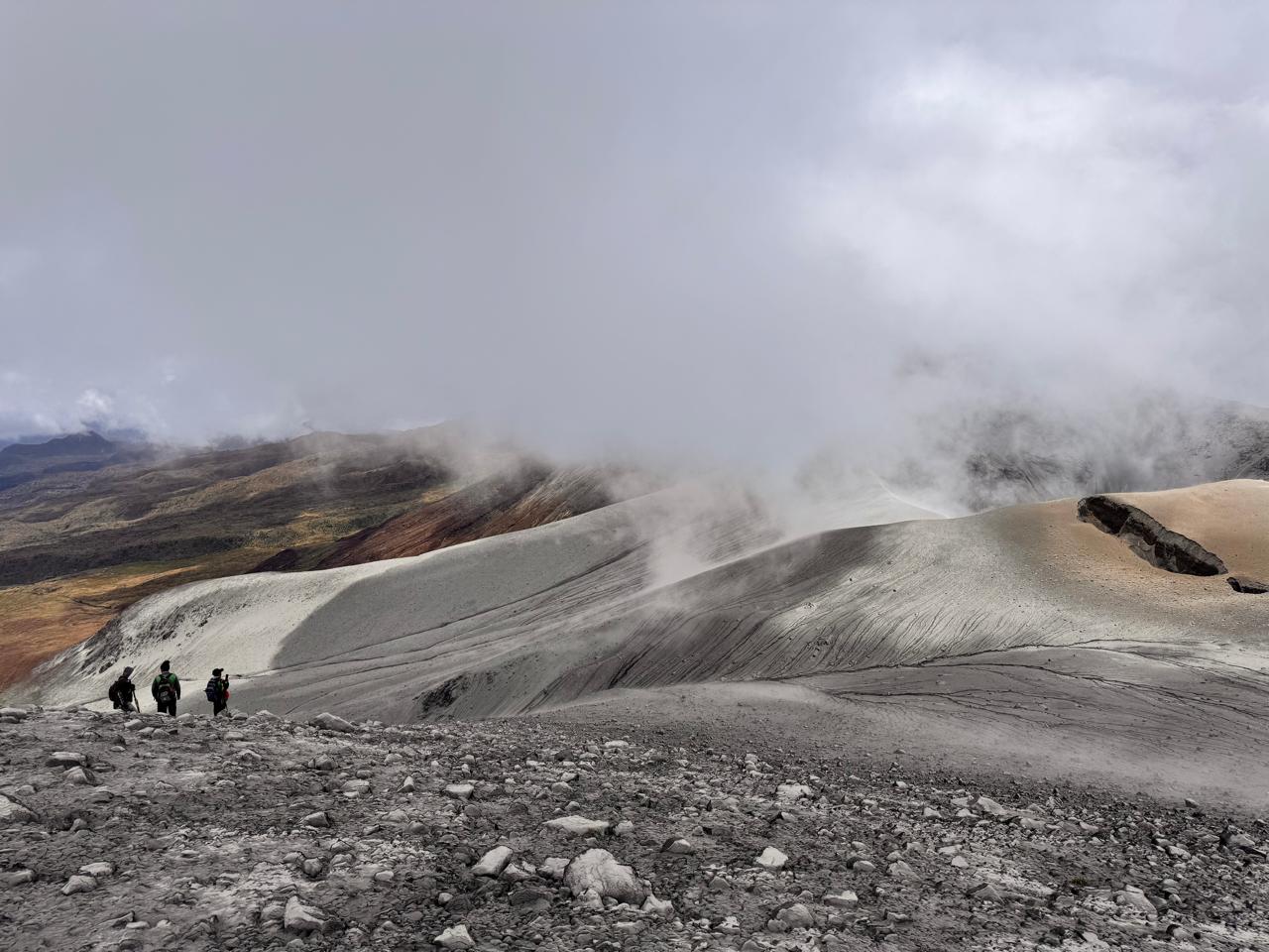
Satellite and field detection instruments continued to record an increase in sulfur dioxide (SO2) emissions compared to previous weeks.
Furthermore, the slow deformation process detected after the eruption of Curiquinga Volcano on January 20, 2025, continues.
Images captured by satellite sensors and visible and infrared webcams continued to show degassing processes and thermal anomalies inside the Puracé Volcano crater and in the fumarole field on its outer rim.
In conclusion, the variations observed at Puracé Volcano – Los Coconucos volcanic chain indicate that the system remains active and that monitoring parameters remain above their reference values. Therefore, the community is advised to avoid any ascent to the upper reaches of the volcanic chain.
At yellow alert status, phenomena such as sporadic ash emissions (minor eruptions of limited magnitude and impact, whose dispersion depends on wind direction), the presence of incandescence, small explosions in the crater, low-energy thermal anomalies, noise, felt earthquakes, odors, precipitation of elemental sulfur near the crater, in hot springs and fumaroles, as well as degassing outside the crater, may occur. Fissure formation and the presence of minor lahars, among other things, may also occur.
The alert status for volcanic activity remains at yellow alert: an active volcano exhibiting changes in the baseline behavior of monitored parameters and other manifestations.
Source et photo : SGC.