February 19 , 2024.
Kamchatka , Sheveluch :
VOLCANO OBSERVATORY NOTICE FOR AVIATION (VONA)
Issued: February 19 , 2024
Volcano: Sheveluch (CAVW #300270)
Current aviation colour code: ORANGE
Previous aviation colour code: orange
Source: KVERT
Notice Number: 2024-09
Volcano Location: N 56 deg 38 min E 161 deg 18 min
Area: Kamchatka, Russia
Summit Elevation: 3283 m (10768.24 ft), the dome elevation ~2500 m (8200 ft)
Volcanic Activity Summary:
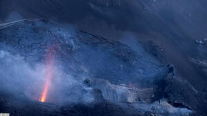
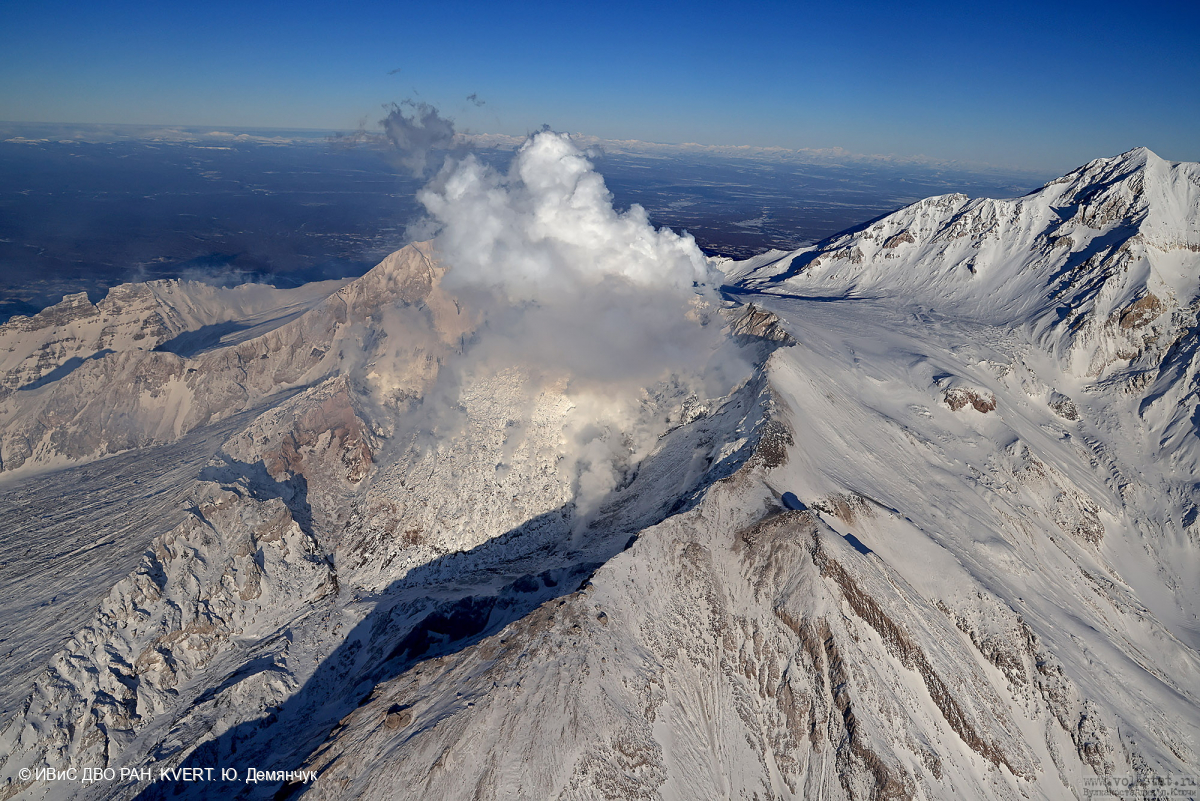
Video and satellite data by KVERT shows a strong wind lifts ash from the southern slopes of Sheveluch volcano, and a plume of resuspended ash is extending about 55 km to the eastsouth-east of the volcano.
An extrusive-effusive eruption of the volcano continues. A danger of ash explosions up to 6 km (19,700 ft) a.s.l. remains. Ongoing activity could affect low-flying aircraft.
Volcanic cloud height:
2500 m (8200 ft) AMSL Time and method of ash plume/cloud height determination: 20240219/0242Z – Video data
Other volcanic cloud information:
Distance of ash plume/cloud of the volcano: 55 km (34 mi)
Direction of drift of ash plume/cloud of the volcano: ESE / azimuth 112 deg
Time and method of ash plume/cloud determination: 20240219/0210Z – Himawari-9 14m15
Source : Kvert.
Photo : Yu. Demyanchuk. IVS FEB RAS, KVERT
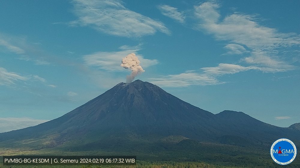
Indonesia , Semeru :
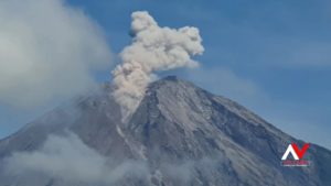
Mount Semeru erupted on Monday, February 19, 2024, at 06:15 WIB. The height of the eruptive column was observed to be ±1,000 m above the peak (±4,676 m above sea level). The ash column was observed to be white to gray in color with thick intensity, oriented towards the North and Northwest. At the time of writing, the eruption was still ongoing.
VOLCANO OBSERVATORY NOTICE FOR AVIATION – VONA
Issued : February 18 , 2024
Volcano : Semeru (263300)
Current Aviation Colour Code : ORANGE
Previous Aviation Colour Code : orange
Source : Semeru Volcano Observatory
Notice Number : 2024SMR120
Volcano Location : S 08 deg 06 min 29 sec E 112 deg 55 min 12 sec
Area : East java, Indonesia
Summit Elevation : 11763 FT (3676 M)
Volcanic Activity Summary :
Eruption with volcanic ash cloud at 23h15 UTC (06h15 local).
Volcanic Cloud Height :
Best estimate of ash-cloud top is around 14963 FT (4676 M) above sea level or 3200 FT (1000 M) above summit. May be higher than what can be observed clearly. Source of height data: ground observer.
Other Volcanic Cloud Information :
Ash cloud moving from north to northwest. Volcanic ash is observed to be white to gray. The intensity of volcanic ash is observed to be thick.
Remarks :
Eruption recorded on seismogram with maximum amplitude 22 mm and maximum duration 188 second.
Source : Magma Indonésie.
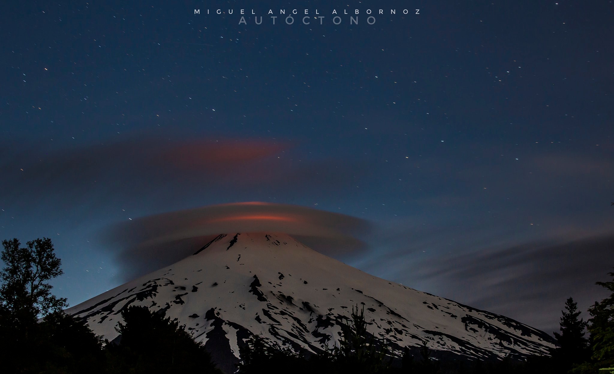
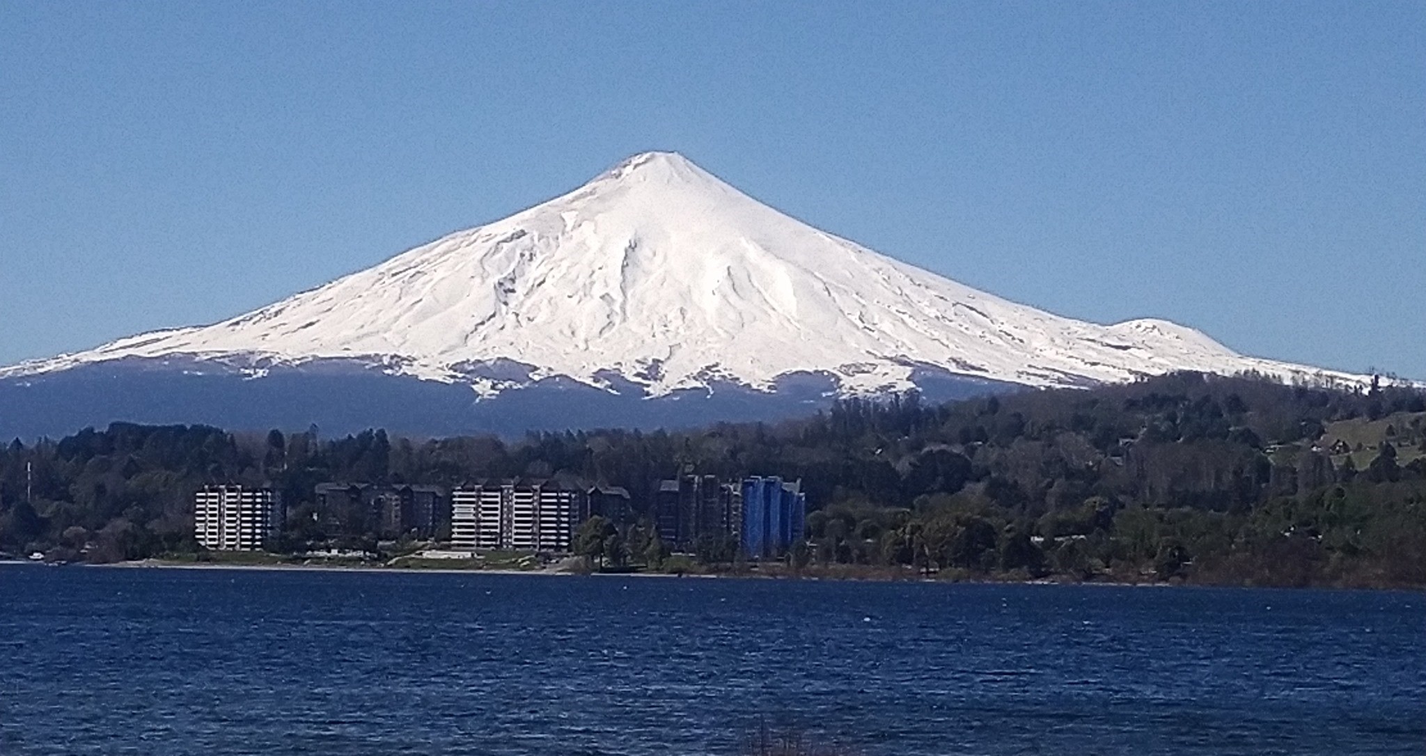
Chile , Villarica :
Seismology
The seismological activity of the period was characterized by the recording of:
559 seismic events of type VT, associated with the fracturing of rocks (Volcano-Tectonics). The most energetic earthquake had a Local Magnitude (ML) value equal to 3.8, located 4.8 km east of the volcanic edifice, at a depth of 4.6 km from the crater.
12033 LP type seismic events, associated with fluid dynamics inside the volcanic system (Long Period). The size of the largest earthquake evaluated from the Reduced Displacement (RD) parameter was equal to 65 cm2.
2559 seismic events of type TR, associated with the dynamics maintained over time of fluids inside the volcanic system (TRemor). The size of the largest earthquake evaluated from the Reduced Displacement (RD) parameter was equal to 47 cm2.
Fluid geochemistry
The sulfur dioxide (SO2) emissions data obtained by the differential optical absorption spectroscopy (DOAS) equipment, corresponding to the Los Nevados and Tralco stations, installed respectively at 10 km in an East-North-East direction and 6 km East-South-East of the active crater, presented an average value of 1130 ± 91 t/d, which represents moderate values for this volcanic system. The maximum daily value was 2397 t/d on January 26, considered abnormal.
8 satellite anomalies were reported in the emissions of sulfur dioxide (SO2) into the atmosphere in the area near the volcano, on January 16, 20, 21, 22, 23, 26, 27 and 28, according to data published by Tropospheric Monitoring Instrument (TROPOMI), Mounts and daily data from Pluem Traj.
Thermal anomalies by satellites
During the period, 44 thermal alerts were recorded in the area associated with the volcano, with a maximum volcanic radiative power (VRP) of 189 MW on January 31, a value considered high according to data processed by the Observation of the volcanic activity in the mid-infrared. (MIROVA).
Thanks to the analysis of Sentinel 2-L2A satellite images, 6 radiance anomalies were detected in the area associated with the crater during the evaluated period. The NHI tool platform detected a maximum area of anomalous radiation in the crater area of 72,000 m2 on January 29.
Geodesy
Geodetic activity was characterized by:
– Slight variations in monitoring station components.
– Displacement rate of medium magnitude and with slight changes compared to the previous period. Monitoring the extension of the North-East line by 0.7 cm/month.
– A slight change is evident in the components which could indicate a low-magnitude inflationary process in the East-Southeast sector of the volcanic building, but monitoring will continue in the coming weeks.
– Thanks to InSar, no sign of deformation is observed.
In conclusion, a state of instability of the volcano is evident, in terms of deformation, but with subtle changes that could indicate low inflation.
Surveillance cameras
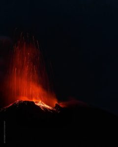
From the surveillance cameras installed on the volcano, whitish columns of degassing mainly associated with water vapor were observed, with a maximum height of 1,100 m on January 20. For their part, columns containing pyroclasts were observed throughout the fortnight, characterized by passive emissions, brown in color and a low pyroclast load. Towards the end of the evaluation period, on January 30 and 31, explosive activity was noted, corresponding to pulsatile Strombolian explosions which did not exceed 200 m in height above the level of the crater. Likewise, a greater impact of pyroclasts can be observed outside the crater rim, mainly in the Northeast, Southeast, and Southwest. Nocturnal incandescence was recorded continuously during the evaluation period, associated with both Strombolian activity and lava lake reflectance.
For the period evaluated, we distinguish seismic activity which remains above its base threshold, presenting variations in the value of the amplitude of the continuous signal similar to the previous fortnight, from LP type events with reduced displacements. high and VT earthquakes with a maximum ML of 3.9. In addition, surface activity characterized by degassing, pyroclastic emission and Strombolian activity was recorded in the proximal sections of the crater. Due to the above, the system remains very active and with changes in its dynamics mainly associated with the movement of magma in the conduit, the superficial and deep lava lake.
The technical alert is maintained in:
YELLOW TECHNICAL ALERT: Changes in the behavior of volcanic activity.
Source : Sernageomin.
Photos : Miguel Angel Albornoz , Volcan Villarica / FB.
Guatemala , Fuego :
Weather conditions: Clear weather
Wind: South, South-East
Precipitation: 0.0 mm.
Activity:
The Fuego volcano maintains explosions, weak, moderate and some strong, accompanied by columns of ash between 4,500 and 4,800 meters above sea level (14,763 – 15,748 feet) moving towards the North-West, North, North -East, for approximately 30 km. Ash falls are recorded in Yepocapa, in the villages of Quisache, La Soledad, Acatenango, El Campamento, with the possibility of spreading to Chimaltenango, La Antigua Guatemala and others in that direction.

This activity generates rumblings, shock waves, moderate to strong avalanches which cascade down the slopes of the volcano. It must be taken into account that strong explosions project ballistic elements above the board and it is extremely dangerous to climb and/or stay in this place, as they can cause serious damage. Also take into account that moderate rain may occur in the volcanic area, so care should be taken when passing vehicles through the rivers and ravines around the volcano.
Source : Insivumeh
Photo : Conred.
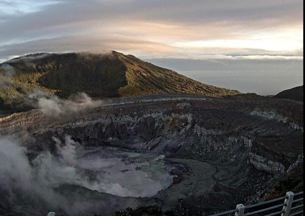
Costa Rica , Poas :
Daily report on the state of volcanoes. OVSICORI-UNA, February 18, 2024, Updated at: 10:08:00.
Latitude: 10.2
Length: -84233
Altitude: 2,687 meters above sea level
Activity observed:
No eruption is recorded. Last night, incandescence was observed near mouth A due to sulfur combustion. Concentrations of up to 2.6 ppm SO2 were recorded at the viewpoint this morning. The tremor remains continuous and moderate. Bubbling-like activity in the mouth C remains weak. A high CO2/SO2 value was recorded early in the morning, but H2S/SO2 remains stable.
High gas concentrations are reported in the visitor center, while concentrations of up to 4 ppm SO2 are recorded at the viewpoint. The high gas concentrations are due to atmospheric conditions and not significant changes in the behavior of the volcano. The tremor increased this morning after 9am. Gas ratios remain relatively stable. Geodetic stations continue to show contraction of the crater.
Environmental conditions:
Partly cloudy; Little wind
Activity Level: Warning (2)
Source : Ovsicori .
Photo : Ovsicori ( Archive)