February 05 , 2022 . EN . Indonesia : Anak Krakatau , Indonesia : Merapi , Alaska : Davidof , Italy / Sicily : Etna , Russia / Kuriles Islands : Chikurachki , Dominica : Boiling Lake .

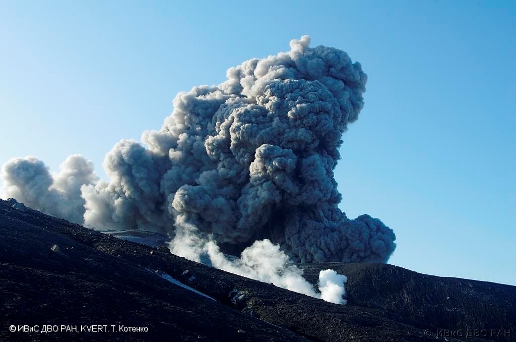
February 05 , 2022 .


Indonesia , Anak Krakatau :

VOLCANO OBSERVATORY NOTICE FOR AVIATION – VONA

Issued : February 05 , 2022
Volcano : Anak Krakatau (262000)
Current Aviation Colour Code : ORANGE
Previous Aviation Colour Code : orange
Source : Anak Krakatau Volcano Observatory
Notice Number : 2022KRA10
Volcano Location : S 06 deg 06 min 07 sec E 105 deg 25 min 23 sec
Area : Lampung, Indonesia
Summit Elevation : 502 FT (157 M)

Volcanic Activity Summary :
Eruption with ash clouds at 03:41 UTC (10:41 local time). The eruption lasted for 61 seconds.
Eruption with volcanic ash cloud at 06:03 UTC (13:03 local)

Volcanic Cloud Height :
Best estimate of ash-cloud top is around 6902 FT (2157 M) above sea level, may be higher than what can be observed clearly. Source of height data: ground observer.

Other Volcanic Cloud Information :
Visuals directly from the cctv were observed eruptions with the color of the thick black eruption smoke 2000m from the top of the volcano, the wind direction slowly to the south east.

Remarks :
Eruption recorded on seismogram with maximum amplitude 60 mm and maximum duration 144 second and Seismic activity is characterized by continuous volcanic tremor

The Geological Agency of the Ministry of Energy and Mineral Resources (ESDM) has urged the public not to approach Mount Anak Krakatu within 2 kilometers (km) of the active crater, due to the eruption today, Friday (4/2). Geological Agency chief Eko Budi Lelono said the eruption of Mount Anak Krakatau had been observed 9 times with the height of the ash column ranging from 800 to 1000 meters above the summit and the color of the thick emission column was grey-black. At night, an incandescence was observed above the crater.

For this February 2022 eruption period, an increase in magmatic intrusion is likely to have begun since December 20, 2021, indicated by the recording of deep volcanic and shallow volcanic earthquakes in significant numbers. In January 2022, volcanic seismicity is still observed quite high and shallow earthquakes are increasingly recorded. At the end of January 2021, it is indicated that the magma is already at a very shallow depth and that ash emissions began to be observed since February 3, 2022 around 10:00 p.m. On February 4, 2022, 9 seismic eruptions were recorded at 9:43 a.m., 10:25 a.m., 10:28 a.m., 12:46 p.m., 1:00 p.m., 1:31 p.m., 1:41 p.m., 2:46 p.m. and 5:07 p.m. WIB.

In addition, the energy of volcanic activity reflected by the value of RSAM (real-time seismic amplitude measurement) shows a pattern of fluctuations with a relatively upward trend in the period January – February 2022. This increase is associated with an increase in low frequency earthquake swarms and continuous tremors which increase relatively in energy both in the number and in the magnitude of the amplitude of the earthquakes caused by the release of energy which occurs during the discharge of fluid to the surface.

Sources and photos : Magma Indonésie , PVMBG.


Indonesia , Merapi :

Merapi activity report from January 28 to February 3, 2022.

– The weather around Mount Merapi is generally sunny in the morning and evening, while it is foggy in the afternoon.
– This week 2 hot avalanche clouds were observed towards the South-West, upstream of the Bebeng river with a sliding distance of 2,000 to 2,500 m. Lava avalanches were observed 133 times to the southwest, upstream of the Bebeng river with a maximum slip distance of 2,000 m, and 1 time to the northwest (upstream of the Apu and Trising rivers) with a sliding distance of 300 m.
– Based on the morphological analysis, no significant morphological changes were observed in either the Southwest lava dome or the central dome. The volume of the Southwest lava dome is 1,670,000 m3 and the central dome is 3,007,000 m3.

– The intensity of seismicity this week is higher than last week. We record:
-2 hot avalanche clouds
– 128 avalanche earthquakes
– 9 emission earthquakes
– 59 hybrid/multi-phase earthquakes
– 13 shallow volcanic earthquakes
– 1 distant tectonic earthquake

Mount Merapi’s deformation, which was monitored using EDM this week, showed a distance shortening rate of 1.6 cm/day.
– Rainfall intensity was 167mm/hour for 70 minutes at Kaliurang post on Feb 3, 2022 and it was reported that there was flooding in Boyong and Kali Kuning rivers.

Conclusion:
1. The volcanic activity of Mount Merapi is still quite high in the form of effusive eruption activity. The state of the activity is defined at the « SIAGA » level.
2. The current potential danger is in the form of lava avalanches and hot clouds in the South-South-West sector covering the Boyong River for a maximum of 5 km, the Bedog River, Krasak, Bebeng for a maximum of 7 km. The Southeast sector covers the Woro River for a maximum of 3 km and the Gendol River for a maximum of 5 km. Meanwhile, the ejection of volcanic material in the event of an explosive eruption can reach a radius of 3 km around the summit.

Sources : BPPTKG , PVMBG.

Photo : ANTARA  /Hendra Nurdiyansyah


Alaska , Davidof :

51°57’15 » N 178°19’34 » E,
Summit Elevation 1076 ft (328 m)
Current Volcano Alert Level: ADVISORY
Current Aviation Color Code: YELLOW

An earthquake swarm in the vicinity of Davidof volcano that began on Monday, January 24, has continued with small earthquakes detected every day this past week. The largest earthquake this week happened on January 29 at 1:34 AM AKST (09:34 UTC) and had a magnitude of 4.0. A similar earthquake swarm occurred in December 2021. No signs of unrest have been observed in partly cloudy satellite images of the volcano this week. This earthquake activity may be associated with volcanic unrest, or could be due to regional tectonic activity.

Davidof and Segula islands viewed from the west side of Little Sitkin

There is no real-time seismic monitoring network at Davidof volcano. The closest seismometers are approximately 9 miles (15 km) to the east of the volcano on Little Sitkin Island. Davidof is also monitored by satellite data and remote infrasound and lightning networks.

Source : AVO

Photo : Loewen, Matt / Alaska Volcano Observatory / U.S. Geological Survey


Italy / Sicily , Etna : 

Press release on ETNA activity, 04 February 2022, 13:00 (12:00 UTC).

The National Institute of Geophysics and Volcanology, Osservatorio Etneo reports that Strombolian activity at the Southeast Crater has ceased. In addition, by analyzing the images of the INGV-OE surveillance cameras, from February 2, the light and discontinuous emissions of volcanic ash communicated in updates n. 531 of January 30 and no. 532 of January 31 are no longer observed.

The magnitude of the shaking is still in the low range. The sources of the signal are located between the central craters and the Southeast crater. Infrasound activity is weak. The sources of the infrasonic signal are located near the Bocca Nuova.
The stations of the ground deformation monitoring networks (GPS and tilt) operating on Etna do not show significant variations.

Further updates will be communicated soon.

Source : INGV.

Photo : Gio Giusa .


Russia / Kuriles Islands , Chikurachki :

VOLCANO OBSERVATORY NOTICE FOR AVIATION (VONA)

Issued: February 05 , 2022
Volcano: Chikurachki (CAVW #290360)
Current aviation colour code: GREEN
Previous aviation colour code: yellow
Source: KVERT
Notice Number: 2022-15
Volcano Location: N 50 deg 19 min E 155 deg 27 min
Area: Northern Kuriles, Russia
Summit Elevation: 1816 m (5956.48 ft)

Volcanic Activity Summary:
A gas-steam activity of the volcano continues. The explosive eruption of the volcano began near 16:00 UTC on 30 January, and finished on 02 February. Explosions sent ash up to 5 km a.s.l., and ash plumes and clouds moved for 255 km west, southwest, south and southeast of the volcano during the eruption. KVERT continues to monitor Chikurachki volcano.
A gas-steam activity of the volcano continues. Ongoing activity could affect low-flying aircraft.

Volcanic cloud height: NO ASH CLOUD PRODUSED
Other volcanic cloud information: NO ASH CLOUD PRODUSED

Source : Kvert

Photo : M. Karasev ( 2015) .


La Dominique , Boiling Lake :

Update on the Boiling Lake February 3 , 2022 .
 
The University of the West Indies Seismic Research Centre (UWI SRC) has informed the Office of Disaster Management (ODM) that as of February 2nd, 2022, the water level and geothermal activity (heat and gas emissions) at the Boiling Lake has decreased significantly. The observed changes at the Boiling Lake are not necessarily related to increased volcanic activity in the area.
The current period of significant changes in activity at the lake began in November 2021. Significant water level changes at the Boiling Lake are not a new phenomenon, but has occurred several times since 1876. In fact, reports indicated that the lake levels have dropped dramatically and have been restored at least eight times in the past. The last draining episode occurred on 8 November, 2016 with the lake returning to its normal state by 10 January, 2017.
 
 
Be advised that these periods of instability can last for weeks to months before normal activity is fully re-established. As this current episode continues, the risk of harmful gases such as Carbon Dioxide and small steam explosions is heightened.
The ODM is advising the public to remain calm. Visits to the Boiling Lake should be avoided at this stage unless approved by the relevant authorities. The public is asked to keep updated on information provided by the authorities.
The UWI-SRC and the Office of Disaster Management, with support from the Forestry, Wildlife & Parks Division, will continue to monitor the situation and provide updates as necessary.

Source : ODM /UWI.

December 10, 2021. EN. Iceland : Grímsvötn , Spain / La Palma : Cumbre Vieja , Russia / Northern Kurils : Ebeko , Colombia : Nevado del Ruiz , Hawaii : Kilauea .

December 10 , 2021 .


Iceland , Grímsvötn :

Flood in Grímsvötn , Update 8.12. at 12:30

The Icelandic Meteorological Office elevated the aviation color code from yellow to orange on the 6th of December for Grímsvötn volcano when the seismic actvity increased above normal level in the aftermath of the glacial outburst (which peaked on 05.12). On that day a M3,6 earthquake occurred at 6:16 UTC and 15 more earthquakes occured within the day. However, yesterday (07.12) very few earthquakes were identified in the area and the geophysical parameters all showed normal values. Based on these current observations, IMO moved the aviation color code from orange back to yellow as there were no clear indications for an imminent eruption.

„When the seismicity increased we needed to react as it could have been a typical precursor of a volcanic eruption“ says Kristín Jónsdóttir Team leader for operational natural hazard monitoring at IMO.

„We need to react to any relevant changes in the volcano activity. In this case it was likely that an eruption would have been triggered by the flood, and sometimes the time between the two events is not that long so we needed to be ready. This scenario, that a flood will trigger an eruption is becoming less likely as time passes“, says Kristín.

The Grímsvötn volcanic system is the most active system in Iceland and has erupted about 70 times during the last 1100 years. The precursors of an eruption can be very short and this is the reason why it is very important to monitor the area closely and to be ready to respond to any evident changes in the volcanic system.

Scientists will continue to monitor the area closely although there are currently no indications of an imminent eruption at Grísmvötn.

The discharge in Gígjukvísl river is decreasing bu the conductivity is still high, which indicates that geothermal water is in the river.

Source : Vedur is.

Photo : GVP. NASA_Earth_Observatory


Spain / La Palma , Cumbre Vieja :

December 09, 2021 10:00 UTC. Eruptive activity continues on La Palma.

Since the last declaration, a total of 32 earthquakes have been located on the island of La Palma, none of them have been felt by the population.
The maximum recorded magnitude is 3.6 (mbLg), corresponding to yesterday’s earthquake at 12:09 UTC, at a depth of 37 km.
Seismicity continues under the central area of Cumbre Vieja in the same areas of the previous days, most earthquakes (20) are located at depths between 9 and 22 km, the rest (12) were located at depths between 32 and 37 km. No earthquake was located at depths less than 9 km.

The amplitude of the tremor signal remains at low levels and is just as stable as the previous days.
As in previous days, the island’s network of permanent GNSS stations does not show a clear trend in the deformation of the stations closest to the eruptive centers.
In the rest of the stations, the slight deflation possibly linked to the deep seismicity has stabilized, except in LP01 which continues to record it.

In view of the image calibrated at 08:45 UTC, an ash cloud height of 1700 m is estimated, dispersing in a southwest direction.
Yesterday at 20:05 UTC, due to the significant increase in the height of the eruptive column, the IGN issued a new VONA (Volcano Observatory Notice for Aviation) message indicating that the maximum height of said column was 2,500 m on the sea level.

The persons in charge of the volcanic emergency plan of the Canary Islands (Pevolca) gave a press conference this Thursday during which they took stock of the situation of the eruption of the volcano Cumbre Vieja, on the Canary island of La Palma. Here are the most remarkable data:

Several emission centers remain active in the south-eastern part of the main cone, with sporadic pulses of Strombolian activity and ash emission.
Cracks and fractures in the upper part of the secondary cone altered the morphology of this cone, producing small collapses towards its interior and adjacent craters.
The height of the scatter cloud measured today was 1,700 m. The expected ash cloud disposition is a favorable scenario for aeronautical operability.

The possible interruption of the lava emission on La Palma does not imply the end of the emergency due to the eruption, because the degassing of the eruptive center and the flows can last for months, warned the volcanic emergency of the Canary Islands (Pevolca). Blanco, director of the Canary Islands of the National Geographic Institute (IGN), explained that the submarine volcano Tagoro, which erupted near the coast of El Hierro a decade ago, continued to emit gas for several months after the end of the eruption and the same is likely to be true in the case of La Palma.

Sources : IGNes , El Pais .

Photo : MIGUEL CALERO / El Pais. I love the world.


Russia , Northern Kurils , Ebeko :

VOLCANO OBSERVATORY NOTICE FOR AVIATION (VONA)

Issued: December 09 ,2021 .
Volcano: Ebeko (CAVW #290380)
Current aviation colour code: GREEN
Previous aviation colour code: yellow
Source: KVERT
Notice Number: 2021-154
Volcano Location: N 50 deg 41 min E 156 deg 0 min
Area: Northern Kuriles, Russia
Summit Elevation: 1156 m (3791.68 ft)


Volcanic Activity Summary:
A moderate gas-steam activity of the volcano continues, but an eruptive event was observed on 09 November, 2021, last time. A thermal anomaly over the volcano was noting on 25 October, 2021, last time. Probably the explosive eruption when began on 20 October, 2016, ended on 09 November, 2021. KVERT continues to monitor Ebeko volcano.
A moderate gas-steam activity of the volcano will continues. Ongoing activity could affect low-flying aircraft.

Volcanic cloud height: NO ASH CLOUD PRODUSED
Other volcanic cloud information: NO ASH CLOUD PRODUSED

Source : Kvert.

Photo : RIA Novosti Alexander Piragis


Colombia , Nevado del Ruiz :

Weekly activity bulletin of the Nevado del Ruiz volcano.
The activity level continues at: Yellow activity level or (III): changes in the behavior of volcanic activity.

Regarding the monitoring of the activity of the Nevado del Ruiz volcano, the COLOMBIAN GEOLOGICAL SERVICE reports that:

The seismicity linked to the dynamics of the fluids inside the volcanic conduits has slightly increased in the number of recorded earthquakes and in the released seismic energy. This seismic activity was characterized by the appearance of continuous volcanic tremor, tremor pulses, earthquakes of long types and very long periods, which presented moderate energy levels and variable spectral content. These earthquakes were located mainly in the Arenas crater. Some of these signals were associated with ash emissions, confirmed by the cameras installed in the area of ​​the volcano and by the report of the officials of the Colombian geological service and the Los Nevados National Natural Park.

The seismicity generated by the fracturing of the rock increased slightly in number of earthquakes and in seismic energy released compared to the previous week. This seismic activity was located mainly in the North-West, North-East and South-East sectors of the volcano and in the Arenas crater.

The depths of the earthquakes ranged from 0.6 to 6.6 km. The maximum magnitude recorded during the week was 1.5 ML (Local Magnitude) corresponding to the earthquake recorded on December 2 at 3:15 p.m. (local time), located 1.3 km north-northwest of the Arenas crater, at a depth of 1.6 km.

Source : SGC

Photo : Ramirez Jorge.


Hawaii , Kilauea :

19°25’16 » N 155°17’13 » W,
Summit Elevation 4091 ft (1247 m)
Current Volcano Alert Level: WATCH
Current Aviation Color Code: ORANGE

Activity Summary:
Kīlauea volcano is erupting from a single vent in the western wall of Halemaʻumaʻu crater. The vent continues to supply lava to a lava lake in the western portion of the crater. All recent lava activity remains confined within Halemaʻumaʻu crater in Hawai‘i Volcanoes National Park.

Summit Observations:
The eruption of lava continues from the western vent in Halema‘uma‘u crater. Deflationary tilt began yesterday afternoon, and switched to inflationary tilt just before midnight. Earthquake activity remains below background. The most recent measurement of sulfur dioxide (SO2) emission rates on November 29, 2021 was approximately 1200 tonnes per day. No new measurements have been made due to recent weather conditions.

Halemaʻumaʻu Lava Lake Observations:
Lava continues to erupt from a single vent in the western wall of Halemaʻumaʻu crater, supplying lava into the lava lake that is contained within the western portion of the crater. Spattering continues within a small lava pond at the vent, and sporadic ooze-outs of lava are present along the solidified lake margins. Lake activity decreased slightly yesterday evening with summit deflation, but increased around midnight with summit inflation. The lake has seen a total increase of about 65 meters (213 ft) since lava emerged on September 29.

Source : HVO.

Photo : Bruce Omori.


October 31, 2021. EN . Spain / La Palma : Cumbre Vieja , Alaska : Great Sitkin , Russia / Kuril Islands : Ebeko , Iceland : Fagradalsfjall , Indonesia : Semeru .

October 31 , 2021.


Spain / La Palma , Cumbre Vieja :

October 30, 2021, 08:00 UTC. Eruptive activity continues in La Palma.

Since the last declaration, 123 earthquakes have been located in the area affected by the volcanic reactivation of Cumbre Vieja, 11 of these earthquakes were felt by the population, having reached the maximum intensity in the epicentral zone IV-V (EMS98 ) with the earthquake which occurred at 6:24 a.m. (UTC) today, with the magnitude of M5.0, mblg, at a depth of 35 km. This earthquake is the largest in magnitude since the start of the eruption.

6 earthquakes were located at depths around 30 km, the rest of the hypocenters of the period are located at a lower depth, around 12 km.
The amplitude of the volcanic tremor signal was maintained at high average levels, with intensifying pulses.
The network of permanent stations on the island shows that the elevation recorded on the 25th at station LP03, which is closest to the eruptive centers, has completely disappeared. However, part of the southern deformation recorded by the station has been consolidated.

In the most remote stations, a slight deflation possibly linked to deep seismicity seems moderate.
Taking into account the calibrated image, an emission column height of 4000 m is estimated at 7.45 am UTC.

The 24-hour permanent volcanic monitoring network of the National Geographic Institute (IGN) located overnight on the island of La Palma a total of 42 earthquakes associated with the eruption of the Cumbre Vieja volcano, a dozen of them of magnitude greater than 3 (mbLg).

At 07:24, there was an earthquake of M 5 (mbLg), the maximum magnitude recorded since the start of the volcanic crisis, located southwest of the municipality of Villa de Mazo at a depth of 35 km. This earthquake was felt in many points of La Palma as well as in Gomera, El Hierro and Tenerife.

The southernmost lava flow of the Cumbre Vieja volcano approaches the coast. The technical director of the Canary Islands Volcanic Emergency Plan, Miguel Ángel Morcuende, explained on Saturday that it is already less than 400 meters from the sea, having traveled around 1,500 meters in the past 24 hours.

The eruption maintains a pattern of behavior similar to that of the past few days. The morphology of the cone has not changed over the past 24 hours, but remains possible.

· The South flow continues to move over previously unaffected land and has advanced approximately 1,500 meters over the past 24 hours.

The volcano recorded on Friday afternoon and for several hours an episode of audible explosions of great intensity, emitting a considerable volume of ash, covering the entire Aridane Valley, as reported on Saturday by the director of the National Geographical Institute (IGN) in the Canary Islands and spokesperson for the scientific committee of Pevolca, María José Blanco, who explained that this episode was caused by a process of intensification of the degassing.

Source : IGN es , El Pais .

Photos : I love the world


Alaska , Great Sitkin :

52°4’35 » N 176°6’39 » W,
Summit Elevation 5709 ft (1740 m)
Current Volcano Alert Level: WATCH
Current Aviation Color Code: ORANGE

Lava effusion continued this week at Great Sitkin, and lava fills more than half of the summit crater. Satellite imagery through October 27 showed that two lobes of lava, flowing over low points on the crater rim, extend downslope ~600 m (2,000 feet) to the south and west. Lava has also reached the crater rim on its northern periphery. In a few areas, the lava has advanced over snow and is advancing into the glacial ice to the east, but no significant steaming or ponding of water has been observed. This indicates that melt rates are probably low and there are no indications of any imminent hydrologic hazards.

The lava lobes that have overtopped the summit crater rim are flowing into small valleys developed on the volcanic edifice. The terrain is steep in these areas, and blocks of lava and lava rubble could detach from the terminus of the flow lobes without warning and form small rock avalanches in these valleys. Such avalanches may liberate ash and gas and could travel several hundred meters beyond the lava flows; they would be hazardous to anyone in those areas. Satellite imagery shows such a blocky deposit extending downslope beyond the terminus of the west flow lobe.

Local geophysical and web camera data were reestablished this past week on October 23 after a power outage in Adak, Alaska. The level of seismicity was slightly elevated throughout the past week and there were persistent small earthquakes likely associated with the ongoing lava effusion. No explosive activity or ash emissions have been detected in regional seismic, infrasound, or satellite data.

There is no indication of how long lava effusion will continue during the current eruption, and it is possible that explosive activity could occur with little or no warning.

Great Sitkin is monitored by local seismic and infrasound sensors, satellite data, web cameras, and remote infrasound and lightning networks.

Source : AVO

Photos : Ward, Dave , Kruse, Peggy .


Russia / Kuril Islands , Ebeko :

VOLCANO OBSERVATORY NOTICE FOR AVIATION (VONA)

Issued: October 31 , 2021 .
Volcano: Ebeko (CAVW #290380)
Current aviation colour code: ORANGE
Previous aviation colour code: yellow
Source: KVERT
Notice Number: 2021-132
Volcano Location: N 50 deg 41 min E 156 deg 0 min
Area: Northern Kuriles, Russia
Summit Elevation: 1156 m (3791.68 ft)

Volcanic Activity Summary:
A moderate eruptive activity of the volcano continues. According to visual data by volcanologists from Severo-Kurilsk, an explosion sent ash up to 1.8 km a.s.l., an ash cloud is drifting to the north-east of the volcano.
This activity continues. Ash explosions up to 6 km (19,700 ft) a.s.l. could occur at any time. Ongoing activity could affect low-flying aircraft and airport of Severo-Kurilsk.

Volcanic cloud height:
1800 m (5904 ft) AMSL Time and method of ash plume/cloud height determination: 20211031/0127Z – Visual data

Other volcanic cloud information:
Distance of ash plume/cloud of the volcano: 5 km (3 mi)
Direction of drift of ash plume/cloud of the volcano: NE / azimuth 50 deg
Time and method of ash plume/cloud determination: 20211031/0127Z – Visual data

Source : Kvert

Photo : M. Shchekleina, M.V. Lomonosov MGU.


Iceland , Fagradalsfjall :

OCTOBER 29, 2021 . Earthquake activity west of Kleifarvatn lake

On 28-October-2021 , two earthquakes with magnitude of Mw3,6 and Mw3,0 took place west of Kleifarvatn lake (in Krýsuvík-Trölladyngja volcano system). The first earthquake with magnitude of Mw3,6 took place at 18:36 UTC and the second earthquake with magnitude of Mw3,0 took place at 23:11 UTC. Other earthquakes that took place where smaller in magnitude.

Earthquake activity west of Kleifarvatn lake. Two green stars on top of each other show the strongest earthquakes.
The earthquake activity in Krýsuvík-Trölladyngja volcano system. Copyright of this image belongs to Icelandic Met Office.

This earthquake activity seems to be connected to magma movements in the area. It has not yet and might not result in a eruption since this is in a different fissure area. It is unlikely that this activity is connected to the magma movements that are ongoing close to Fagradalsfjall mountain.

Source : icelandgeology.net

Photo : Icelandic Met Office.


Indonesia , Semeru :

VOLCANO OBSERVATORY NOTICE FOR AVIATION – VONA

Issued : October 30 , 2021
Volcano : Semeru (263300)
Current Aviation Colour Code : ORANGE
Previous Aviation Colour Code : orange
Source : Semeru Volcano Observatory
Notice Number : 2021SMR62
Volcano Location : S 08 deg 06 min 29 sec E 112 deg 55 min 12 sec
Area : East java, Indonesia
Summit Elevation : 11763 FT (3676 M)

Volcanic Activity Summary :
Eruption with volcanic ash cloud at 23h03 UTC (06h03 local)

Volcanic Cloud Height :
Best estimate of ash-cloud top is around 13043 FT (4076 M) above sea level, may be higher than what can be observed clearly. Source of height data: ground observer.

Other Volcanic Cloud Information :
Ash-cloud moving to southwest.

Level of activity at Level II (WASPADA). Mount Semeru (3,676 m above sea level) erupts intermittently. Explosive and effusive eruptions are recorded, producing lava flows towards the south and south-eastern slopes, as well as ejections of incandescent rocks around the summit crater. The last eruption occurred on October 19, 2021, and the height of the eruption column was not observed.

The volcano is covered in fog. No smoke from the crater was observed. The weather is sunny to cloudy. The wind is blowing weak to moderate to the southwest and west. The air temperature is around 22-28 ° C.

According to the seismographs of October 30, 2021, it was recorded:
53 eruption / explosion earthquakes
7 earthquakes of emissions

Source : Magma Indonésie , PVMBG.

Photo : Oystein lund Andersen .


August 25 , 2021. EN . Italy : Stromboli , Italy / Sicily : Etna , Hawaii : Kilauea , Russia / Northern Kurils : Ebeko , Colombia : Nevado del Ruiz , Italy : Pompei .

August 25 , 2021.


Italy , Stromboli :

Weekly bulletin, from August 16, 2021 to August 22, 2021 (issue date August 24, 2021)

SUMMARY STATEMENT OF ACTIVITY

In view of the monitoring data, it is highlighted:
1) VOLCANOLOGICAL OBSERVATIONS: During this period a normal explosive activity of strombolian type was observed. The total hourly frequency of explosions fluctuated between medium-low and medium values ​​(9-13 events / h). The intensity of the explosions was mainly low in the areas of the North and Center-South Craters.
2) SEISMOLOGY: The seismological parameters monitored do not show significant variations.
3) DEFORMATIONS: The island’s soil deformation monitoring networks have shown no significant changes over the past week.
4) GEOCHEMISTRY: SO2 flux at a medium-low level
The flow of CO2 from the ground to the Pizzo Sopra la Fossa is at average values.
There is no update of the C / S ratio value. The last measurement measured (07/28/2021) is at average values ​​(C / S = 9.6).
The isotopic ratio of Helium dissolved in the thermal aquifer compared to the last sampling of 07/27/2021 is at medium – high values.
5) SATELLITE OBSERVATIONS: The thermal activity in the summit area is low to moderate.

Fig. 1 – The crater terrace seen by the thermal camera placed on the Pizzo sopra la Fossa with the delimitation of the zones of the Center-South and North crater (ZONE N, ZONE C-S respectively). Abbreviations and arrows indicate the names and locations of active vents, the area above the crater terrace is divided into three height ranges relating to the intensity of the explosions.

VOLCANOLOGICAL OBSERVATIONS
During the observation period, the eruptive activity of Stromboli was characterized thanks to the analysis of the images recorded by the surveillance cameras of the INGV-OE (altitude 190, Punta Corvi, altitude 400m and Pizzo). The explosive activity was mainly produced by 3 (three) eruptive chimneys located in the area of ​​the North crater and by 6 (six) eruptive chimneys located in the area of ​​the Center-South Craters. All the vents are placed inside the depression which occupies the terrace of the crater (Fig. 1).
Due to adverse weather conditions, the visibility of the crater terrace on August 21 was not sufficient for a correct description of the explosive activity.

The N1 crater located in the northern zone, with two emission points, produced low intensity explosions (less than 80 m in height) emitting coarse materials (lapilli and bombs) which fell abundantly with a radial distribution. Vent N2 showed low intensity explosive activity (less than 80 m high) emitting fine material sometimes mixed with coarse material. The average frequency of explosions varied from 3 to 5 events / h.
In the Center-South zone, the S1 vent, located on the cone facing the Sciara, sporadically produced low-intensity explosions, emitting fine materials, sometimes mixed with coarse materials, while the three vents located in the sector S2 produced low intensity explosions projecting coarse materials mixed with fine materials. Sector C produced degassing activities. The frequency of the explosions varied from 5 to 9 events / h.

Source : INGV

Read the full article: https://www.ct.ingv.it/index.php/monitoraggio-e-sorveglianza/prodotti-del-monitoraggio/bollettini-settimanali-multidisciplinari/531-bollettino-settimanale-sul-monitoraggio-vulcanico-geochimico-e-sismico-del-vulcano-Stromboli20210824/file

Photos : INGV , ilvulcanoapiedi


Italy / Sicily , Etna :

Weekly bulletin, from August 16, 2021 to August 22, 2021 (issue date August 24, 2021)

SUMMARY STATEMENT OF ACTIVITY.

In view of the monitoring data, it is highlighted:
1) VOLCANOLOGICAL OBSERVATIONS: Pulsed degassing of the Bocca Nuova crater, ordinary degassing of the other summit craters.
2) SEISMOLOGY: Weak fracturing activity. Low amplitude of tremor.
3) INFRASOUND: overall low infrasound activity
4) DEFORMATIONS: During the last week, there has been no significant change.

Fig. 3.1 – Map of the summit craters of Etna. BN: Bocca Nuova, VOR: Voragine; NEC: northeast crater; SEC: south-eastern crater. The topographic reference frame on which the morphological updates have been superimposed is linked to the 2014 DEM developed by the Aero-geophysical Laboratory – Section Rome 2.

5) GEOCHEMISTRY: The flow of HCl appears at a medium-low level
Medium level SO2 flux
The flux of CO2 emitted by the soil shows a downward trend and is at low values.
The partial pressure of CO2 dissolved in water does not show significant variations.
The isotopic ratio of helium is on average – high values ​​(last sampling of 07/26/2021)
There are no updates for the C / S report.
6) SATELLITE OBSERVATIONS: The thermal activity in the summit area was low to moderate.

VOLCANOLOGICAL OBSERVATIONS
During the week, the monitoring of the volcanic activity of Etna was carried out thanks to the analysis of the images of the surveillance cameras of the INGV, Osservatorio Etneo (INGV-OE). Due to the cloud cover that characterized part of certain days of the week, the observation of volcanic activity by the cameras was discontinuous.
The week was characterized by degassing activities of all the summit craters (Fig. 3.1).

In particular, during the week, the crater of Bocca Nuova (BN) fed a pulsed and almost continuous degassing, presumably from the two vents currently active inside it. The Northeast Crater (NEC) produced intense degassing at a variable rate and the Southeast Crater (SEC) supplied continuous degassing from the fumaroles placed on the eastern edge.
Finally, the Voragine crater (VOR) was characterized by fumarolic degassing.

Volcanic tremor:
The magnitude of the tremor for the week of August 16 to 22, 2021 is low. The locations of the sources are concentrated in the area of the central craters. The depths vary from 1.5 km to 3 km altitude.

Source : INGV

Read the full article : https://www.ct.ingv.it/index.php/monitoraggio-e-sorveglianza/prodotti-del-monitoraggio/bollettini-settimanali-multidisciplinari/532-bollettino-settimanale-sul-monitoraggio-vulcanico-geochimico-e-sismico-del-vulcano-etna20210824/file

Photos : INGV , Gio Giusa.


Hawaii , Kilauea :

HVO/USGS Volcanic Activity Notice

Current Volcano Alert Level: WATCH
Previous Volcano Alert Level: ADVISORY
Current Aviation Color Code: ORANGE
Previous Aviation Color Code: YELLOW

Issued: Tuesday, August 24, 2021, 5:34 AM HST
Source: Hawaiian Volcano Observatory
Notice Number: 2021/H238
Location: N 19 deg 25 min W 155 deg 17 min
Elevation: 4091 ft (1247 m)
Area: Hawaii

Volcanic Activity Summary:
Kīlauea volcano is not erupting. A swarm of earthquakes beneath the south part of Kīlauea caldera, within Hawaiʻi Volcanoes National Park, began on the evening of August 23, 2021. The swarm continues into the early morning hours of August 24 with a particularly strong sequence of earthquakes that occurred at about 1:30 a.m., HST. The onset of the earthquake swarm was coincident with a change in the style of ground deformation at tiltmeters in the Kīlauea summit region, potentially indicating the shallow movement of magma beneath the south part of Kīlauea caldera.

The US Geological Survey Hawaiian Volcano Observatory is raising the volcano alert level/aviation color code for Kīlauea from Advisory/Yellow to Watch/Orange due to this activity.

HVO will continue to monitor this activity closely and adjust the alert level accordingly.

HVO is in constant communication with Hawai‘i Volcanoes National Park as this situation evolves. The activity is confined entirely within the park.

Remarks:
The US Geological Survey Hawaiian Volcano Observatory has detected an increase in earthquake activity beneath the south part of Kīlauea summit caldera, within Hawaiʻi Volcanoes National Park. The activity began around 4:30 p.m., HST, on August 23 and continued through the night and into the early morning of August 24, 2021. The swarm was accompanied by an increase in the style of ground deformation recorded by the Sandhill tiltmeter, just to the west of the earthquake swarm location. The same tilt increase was also recorded by the tiltmeter near Uēkahuna Bluff and the site of the old HVO building.

At about 1:30 a.m. this morning, the swarm of earthquakes intensified in this region; this activity may indicate an intrusion of magma occurring 1–2 km (0.6–1.2 miles) beneath the south caldera.

Over 140 earthquakes have been recorded as of 4:30 a.m. on August 24; the largest recorded earthquake was magnitude 3.3 with the majority of earthquakes less than magnitude 1. Small earthquakes are continuing at a rate of at least 10 detected earthquakes per hour.

Currently, webcams and satellite imagery show no evidence of lava at the surface. HVO scientists will continue the monitor the situation and will issue additional messages and alert level changes as warranted by changing activity.

Next Notice:
The Hawaiian Volcano Observatory (HVO) continues to closely monitor Kīlauea’s seismicity, deformation, and gas emissions for any changes in activity. HVO will now issue daily Kīlauea updates until further notice.

Source : HVO.

Photos : USGS / M. Zoeller. Pu’u’O’o , USGS/ K. Mulliken


Russia / Northern Kurils , Ebeko :

VOLCANO OBSERVATORY NOTICE FOR AVIATION (VONA)

Issued: August 24 , 2021
Volcano: Ebeko (CAVW #290380)
Current aviation colour code: ORANGE
Previous aviation colour code: orange
Source: KVERT
Notice Number: 2021-103
Volcano Location: N 50 deg 41 min E 156 deg 0 min
Area: Northern Kuriles, Russia
Summit Elevation: 1156 m (3791.68 ft)

Volcanic Activity Summary:
A moderate eruptive activity of the volcano continues. According to visual data by volcanologists from Severo-Kurilsk, an explosion sent ash up to 3.7 km a.s.l., an ash cloud is drifting to the south-east of the volcano.
This activity continues. Ash explosions up to 6 km (19,700 ft) a.s.l. could occur at any time. Ongoing activity could affect low-flying aircraft and airport of Severo-Kurilsk.

Volcanic cloud height:
3700 m (12136 ft) AMSL Time and method of ash plume/cloud height determination: 20210824/2148Z – Visual data

Other volcanic cloud information:
Distance of ash plume/cloud of the volcano: 10 km (6 mi)
Direction of drift of ash plume/cloud of the volcano: SE
Time and method of ash plume/cloud determination: 20210824/2148Z – Visual data

Source : Kvert.

Photo : L. Kotenko. IVS FEB RAS.


Colombia , Nevado del Ruiz :

Weekly activity bulletin of the Nevado del Ruiz volcano

The activity level continues at: Yellow activity level or (III): Changes in the behavior of volcanic activity.

Regarding the monitoring of the activity of the Nevado del Ruiz volcano, the COLOMBIAN GEOLOGICAL SERVICE reports that:

Seismicity related to fluid dynamics inside the volcanic conduits showed an increase in the number of earthquakes recorded and a slight decrease in the levels of seismic energy released compared to the previous week. The increase in the number of long-lasting tremor pulses and earthquakes, with varying energies, continues to be highlighted. Very long-lasting earthquakes have also been recorded. These earthquakes were located mainly in the Arenas crater. Some of these signals were associated with ash emissions, confirmed by cameras installed in the volcano area.

The seismicity generated by the fracturing of the rock decreased the number of earthquakes and maintained similar levels in the seismic energy released compared to the previous week. There is a seismic increase in this type of activity recorded on August 20 and 21 in the northeast sector of the Arenas crater, the depths varied between 2.9 and 4.5 km. The highest magnitude recorded during the increase, the largest of the week, was 1.0 ML (local magnitude), at 5:12 a.m. (local time), located 2.5 km northeast of Arenas crater, 3.7 km deep. The other seismic activity recorded during the week was located mainly in the South-East, South-West sectors and in the Arenas crater. The depths of the earthquakes ranged from 0.6 to 7.0 km.

Regarding the « drumbeat » type seismicity, on August 22, there were two episodes of low energy level associated with the fracturing of the rock. This seismicity has been linked to the processes of ascent, location-growth and evolution of a lava dome1 at the bottom of the Arenas crater of the Nevado del Ruiz volcano.

Source et photo : SGC.


Italy , Pompei :

THE EXACT DAY OF THE POMPEII ERUPTION IS OCTOBER 24th, 79 AD
 
The summer date of 24th August, deduced from the letters of Pliny the Younger and accepted for centuries, has now been disproved by a series of archaeological evidence more and more numerous and unequivocal. The discovery of must left to ripen in dolia (terracotta pots), autumn fruits (walnuts, dried figs, chestnuts, plums and pomegranates already harvested), active braziers and, above all, a coin that reports of the fifteenth acclamation of Titus as emperor, which took place after September 8th,79, suggest a fully autumnal date.
 
 
The autumn eruption hypothesis is also supported by a charcoal inscription that came to light some years ago in the House with Garden, where work was being carried out. The masons of the time had marked a date, perhaps that of the begnning of the work: October 17th, 79 AD. Now, even the recent discovery of clothing and woollen fabrics on the fugitives in the cryptoporticus of the villa of Sauro Bardato, leave little room for further doubts and confirm that the time of the eruption of Vesuvius was not « ante diem nonum Kalendas Septembres » (August 24th in the Roman calendar) but « ante diem nonum Kalendas Novembres », that is October 24th.
 
Source : Luigi Maisto
 
Photo : Franco Matrone

10 Aout 2021 . FR . Italie / Sicile : Etna , Etats – Unis : Yellowstone , Indonésie : Raung , Russie / Kouriles du Nord : Chirinkotan , Guatemala : Pacaya .

10 Aout 2021 .


Italie / Sicile , Etna :

Communiqué de presse sur l’activité de l’ETNA , 09 Aout 2021,  03:13 (01:13 UTC) .

L’Institut national de géophysique et de volcanologie, Osservatorio Etneo , annonce qu’à partir de 00h40, il y a une augmentation progressive de l’activité strombolienne en cours au Cratère Sud-Est. La coulée de lave dirigée vers la Valle del Bove semble bien alimentée et a atteint une altitude estimée à environ 2900 m. 
L’activité génère une émission de cendres qui, selon le modèle de prévision, est dirigée vers le Sud-Est.
La phase d’augmentation de l’amplitude moyenne du trémor volcanique se poursuit, qui a atteint des valeurs très élevées. Le centroïde des sources est situé dans la zone du Cratère Sud-Est à une profondeur d’environ 2900 m au-dessus du niveau de la mer. L’activité infrasonore a également connu une augmentation progressive et à partir de 00:40 UTC montre des valeurs élevées, à la fois en référence au taux d’occurrence et à l’amplitude des événements, qui sont situés au Cratère Sud-Est.
Les séries temporelles des stations du réseau inclinométrique montrent des fluctuations modestes de quelques microradians. Aucune variation dans la série temporelle du réseau GNSS.

04:09 (02:09 UTC): Nous observons le passage progressif de l’activité strombolienne au stade de fontaine de lave au Cratère Sud-Est. La coulée de lave de la Valle del Bove continue d’être bien alimentée. De plus, à partir d’environ 01:50 UTC, une deuxième coulée de lave est observée qui se propage dans la direction Sud-Ouest.
Selon le modèle de prévision, le nuage éruptif produit par l’activité en cours se disperse dans le secteur Sud-Est du volcan.

Communiqué de presse sur l’activité de l’ETNA , 09 Aout 2021, 06:48 (04:48 UTC) .
L’Institut national de géophysique et de volcanologie, Osservatorio Etneo, rapporte qu’à environ 04h00 UTC, la fontaine de lave du Cratère Sud-Est a progressivement cessé.
Il reste une modeste émission de cendres qui, sur la base du modèle de prévision, est dispersée vers le Sud-Est. La coulée de lave qui s’étend vers la Valle del Bove et la coulée directe du Sud-Ouest continuent d’être alimentées. Une autre coulée de lave modeste est également observée sur le côté Sud-Est du Cratère Sud-Est.
Quant à l’amplitude moyenne du tremor volcanique, après avoir atteint la valeur maximale à 03:50 UTC, elle a subi une diminution soudaine jusqu’à atteindre des valeurs moyennes-basses. Le centroïde des sources est situé dans la zone du Cratère Sud-Est à une altitude d’environ 2800 m au-dessus du niveau de la mer. L’activité infrasonore, à partir d’environ 04:05 UTC a également subi une diminution rapide, à la fois dans le taux d’occurrence et dans l’ampleur des événements. Actuellement, elle montre des valeurs comparables à celles qui ont a précédé la reprise de l’activité strombolienne au Cratère Sud-Est.


Les séries temporelles des stations supérieures du réseau inclinométrique montrent des variations contenues dans deux microradians. Aucun changement significatif n’a été observé dans les données du réseau GNSS.

08:01 (06:01 UTC) : à 05:40 UTC, il y a eu un effondrement de matériel froid du flanc Est du Cratère Sud-Est, vers la Valle del Bove.

Communiqué de presse sur l’activité de l’ETNA , 09 Aout 2021, 22:13 (20:13 UTC) :

L’Institut national de géophysique et de volcanologie, Osservatorio Etneo , rapporte que l’analyse du réseau de vidéosurveillance montre qu’une faible émission de lave se poursuit depuis la base Est et Sud-Est du Cratère Sud-Est, comme indiqué dans le communiqué de presse précédent. Les coulées de lave restent confinées à une altitude d’environ 2900 m.
La dernière émission de cendres du Cratère Sud-Est s’est produite vers 13h30 UTC.

Le cône Sud-Est et ses laves émises lors du dernier Paroxysme de ces dernières heures. Le bras de lave se dresse à quelques centaines de mètres au-dessus du Monte Frumento Supino

Au cours de la matinée, l’amplitude moyenne du tremor volcanique a montré des fluctuations importantes et soudaines entre des valeurs moyennes-basses et moyennes-hautes, liées à l’apparition de phénomènes transitoires à basse fréquence associés à l’activité explosive au niveau du Cratère Sud-Est et dont les tracés infrasons sont également clairement visible. Actuellement, l’amplitude montre des valeurs moyennes et le centroïde des sources est situé dans la zone du cratère de la Voragine à une altitude d’environ 2700 m d’altitude. En ce qui concerne l’activité infrasonore, à l’exception des phases, mentionnées ci-dessus, d’augmentation rapide du taux d’occurrence et de l’amplitude des événements du Cratère Sud-Est, elle est restée à un niveau moyen-bas avec des sources dans la zone du Cratère de la Bocca Nuova. L’activité infrasonore est actuellement faible. Depuis la dernière mise à jour, aucun changement significatif n’a été observé dans les séries chronologiques des stations de surveillance de la déformation du sol

D’autres mises à jour seront communiquées rapidement.

Source : INGV.

Photos : Giuseppe Distefano / Marco Restivo ( Etnawalk : https://www.facebook.com/photo/?fbid=361943315373793&set=ms.c.eJw1zcENwEAIA8GOIrC5GPpvLAoHzxHWwtcrkAELO6aH17qOa~%3BI9FJU5RqVMjrX3PrR74N~_nYXvV5hnXaaO2790vzl3W~%3B~_FzN3Y~%3B8wMwwyNu.bps.a.361941878707270) , Gio Giusa .

Vidéo : Michele Mammino , https://youtu.be/keNu1Htqq9A


Etats – Unis , Yellowstone :

44°25’48 » N 110°40’12 » O,
Élévation du sommet : 9203 pi (2805 m)
Niveau d’alerte volcan actuel : NORMAL
Code couleur de l’aviation actuel : VERT

Travaux récents et actualités
Le mois de juillet a vu l’essaim de séismes le plus énergétique de la région depuis l’essaim de séismes de Maple Creek de juin-septembre 2017. Bien qu’au-dessus de la moyenne, ce niveau de sismicité n’est pas sans précédent et ne reflète pas une activité magmatique. Les tremblements de terre à Yellowstone sont principalement causés par le mouvement sur des failles préexistantes et peuvent être stimulés par l’augmentation de la pression interstitielle due à la recharge des eaux souterraines suite à la fonte des neiges. Si l’activité magmatique était la cause des séismes, nous nous attendrions à voir d’autres indicateurs, comme des changements dans le style de déformation ou les émissions thermiques/gazeuses, mais aucune de ces variations n’a été détectée.

Il n’y a eu qu’une seule éruption du Steamboat Geyser en juillet 2021, donc le nombre total d’éruptions pour l’année est maintenant de 13. Au cours des derniers mois, le temps entre les éruptions a augmenté, ce qui peut indiquer que la période actuelle d’éruptions fréquentes arrive à une fin progressive.

Juillet a été une période chargée pour les travaux sur le terrain des scientifiques de l’observatoire du volcan Yellowstone. Les sismologues ont récupéré 140 stations sismiques temporaires dans le Norris Geyser Basin, et ils utiliseront les données qu’ils ont recueillies au cours du mois où les stations ont été installées pour comprendre les schémas d’écoulement des eaux souterraines et l’activité des geysers. Les géologues ont passé du temps à cartographier les cratères d’explosion hydrothermale dans le Lower Geyser Basin, en essayant de mieux déterminer leur calendrier et leur style de formation, et ont également collecté des échantillons de coulées de lave voisines pour améliorer les contraintes d’âge sur le volcanisme de Yellowstone. Enfin, des géochimistes ont installé un équipement de surveillance des gaz dans la région du volcan Mud dans une expérience unique en son genre pour fournir des données de concentration continues pour plusieurs espèces de gaz. Une fois les données calibrées et la télémétrie par satellite établie, les données seront disponibles via la page de surveillance de l’observatoire du volcan Yellowstone.

Sismicité
En juillet 2021, les stations sismographiques de l’Université de l’Utah, responsables de l’exploitation et de l’analyse du réseau sismique de Yellowstone, ont localisé 1008 tremblements de terre dans la région du parc national de Yellowstone. Ce nombre est préliminaire et augmentera probablement, car des dizaines d’autres petits tremblements de terre, à partir du 16 juillet, nécessitent une analyse plus approfondie. Il s’agit du plus grand nombre de tremblements de terre en un mois depuis juin 2017, lorsque plus de 1100 tremblements de terre avaient été localisés. Des tremblements de terre comme ceux-ci sont associés à des mouvements sur des failles préexistantes qui peuvent être déclenchés par des augmentations de la pression interstitielle à mesure que les niveaux des eaux souterraines augmentent en raison de la recharge suite à la fonte des neiges. Le plus grand événement du mois dernier a été un tremblement de terre mineur de magnitude 3,6 situé à 11 milles sous le lac Yellowstone, à 7,4 milles au Sud-Sud-Est de Fishing Bridge , Parc national de Yellowstone, le 16 juillet à 18h45 HAR. Cet événement faisait partie d’une séquence énergétique de tremblements de terre dans la même région qui a commencé le 16 juillet.

L ‘Imperial Geyser dans le parc national de Yellowstone mesure environ 30 m (environ 100 pieds) de diamètre et contient des eaux alcalines Cl avec un évent de vapeur dans la piscine et des boues à l’extérieur de la piscine (dans la partie supérieure droite de cette photo). Photo de l’USGS par Pat Shanks, 2019.

La sismicité de juillet à Yellowstone a été marquée par sept essaims de tremblements de terre :

1) Un essaim de 764 tremblements de terre s’est produit sous le lac Yellowstone (avec plusieurs petits tremblements de terre du 16 juillet nécessitant encore une analyse). Il a commencé le 16 juillet et comprend le plus grand événement du mois (magnitude 3,6, détaillé ci-dessus). Cet essaim se compose de quatre séismes de magnitude 3 et 85 de magnitude 2. Ces chiffres seront mis à jour à la fin de l’analyse. Cette séquence a diminué à seulement quelques tremblements de terre par jour mais pourrait se poursuivre jusqu’en août.

2) Un essaim de 40 tremblements de terre, à environ 12 miles à l’Est-Nord-Est de West Yellowstone, MT, qui a commencé le 19 juillet, le plus grand événement (magnitude 2,1) s’étant produit le 23 juillet à 22h20 MDT.

3) Une série de 34 tremblements de terre à environ 11 miles au Nord-Est de West Yellowstone, MT, qui s’est poursuivie en juillet à partir d’un essaim qui a commencé le 19 juin. à 01h12 UTC), à environ 11,5 miles au Nord-Est de West Yellowstone, MT.

4) Une série de 24 tremblements de terre à environ 11 miles au Nord-Est de West Yellowstone, MT, s’est poursuivie jusqu’au 3 juillet (MDT) à partir d’un essaim qui a commencé le 9 juin. Le plus grand événement de juillet (magnitude 2,6) s’est produit le 3 juillet à 07h31. MDT, à environ 14,5 miles au Nord-Nord-Est d’Old Faithful, parc national de Yellowstone.

5) Un essaim de 20 tremblements de terre s’est produit du 29 au 31 juillet au Nord du Norris Geyser Basin dans le parc national de Yellowstone. L’événement le plus important (magnitude 1,9) a eu lieu le 29 juillet à 9 h 31 HAR, à environ 3 milles au Nord de Norris Geyser Basin.

6) Un petit essaim de 14 tremblements de terre s’est produit du 9 au 10 juillet. Le plus grand, M 2.0, a eu lieu à 12 h 08 HAR le 10 juillet, situé à 25 km au Sud d’Old Faithful, dans le parc national de Yellowstone.

7) Un petit essaim de 12 tremblements de terre s’est produit du 10 au 15 juillet. Le plus grand, M 2,7, a eu lieu le 12 juillet à 11 h 34 HAR, situé à 24 km au Nord-Nord-Est d’Old Faithful, dans le parc national de Yellowstone.

Des séquences de tremblements de terre comme celles-ci sont courantes et représentent environ 50% de la sismicité totale dans la région de Yellowstone.

L’activité sismique de Yellowstone est actuellement supérieure aux niveaux de fond.

Angel Terrace, Mammoth Hot Springs, Yellowstone National Park.

Déformation du sol :
L’affaissement de Yellowstone Caldera, qui dure depuis 2015, s’est interrompu pendant les mois d’été, reflétant la recharge saisonnière des eaux souterraines. Chaque été, l’eau de fonte des neiges fait légèrement gonfler le sol, ce qui entraîne une pause dans les tendances d’affaissement ou même un léger soulèvement (moins de 1 cm / fraction de pouce). Dans la région du Norris Geyser Basin, aucun soulèvement ou affaissement significatif n’a été détecté par une station GPS à proximité depuis le début de 2020. Aucune déformation associée à l’essaim de tremblement de terre énergétique sous le lac Yellowstone n’a été notée.

Source : YVO.

Photos : streamboat / Behnaz Hosseini , Pat Shanks. Public domain , JoAnn Holloway. Public domain.


Indonésie , Raung :

Diminution du niveau d’activité du volcan Raung, 09 août 2021.

Le volcan Raung (autre nom : Rawon) est l’un des volcans actifs de Java oriental, avec une hauteur maximale de 3332 mètres au-dessus du niveau de la mer. Ce volcan est un volcan strato-caldeira, avec le cratère principal au sommet en forme d’ellipse d’une taille de 1750 x 2250 m2, et d’une profondeur de 400-550 m depuis le bord du cratère.

Le 21 janvier 2021, le niveau d’activité du mont Raung est passé du niveau I (normal) au niveau II (alerte) après qu’une augmentation significative de l’activité visuelle et de la sismicité ait été observée. La surveillance de l’activité volcanique du mont Raung a été effectuée depuis le poste d’observation du volcan Raung (PGA) situé dans le village de Mangaran, .

I. Observation visuelle
Observations visuelles du volcan Raung du 1er juillet au 8 août 2021: le volcan était clairement visible jusqu’à ce qu’il soit recouvert de brouillard. Aucune fumée issue du cratère n’a été observée. Des émissions de gaz ou des éruptions effusives ou explosives n’ont pas été observées depuis février 2021.

II. Observation instrumentale
La sismicité après la série d’éruptions de janvier-février 2021 a été dominé par des tremblements de terre d’ émissions et des tremblements de terre tectoniques. Les vibrations de tremor sont toujours enregistrées avec une amplitude décroissante. Les séismes volcaniques (Volcaniques profonds, Volcaniques peu profonds) ne sont pas enregistrés.
Les observations d’énergie sismique via le graphique RSAM (mesure de l’amplitude sismique réelle) montrent une tendance à la baisse jusqu’au 8 août 2021.
La mesure de la déformation à travers les inclinométres montre un modèle de déflation (dégonflage du corps du volcan).

III. Danger potentiel
Le danger potentiel d’une éruption du mont Raung est les coulées de lave et l’éjection de roches incandescentes depuis le fond du cratère. Lorsque l’éruption augmente, la distance d’éjection des matériaux rocheux incandescents peut atteindre le bord du cratère. Actuellement, la menace potentielle de danger se présente sous la forme d’émissions de gaz volcaniques dont la distribution est limitée au fond du cratère

IV. Conclusion
Sur la base des résultats de la surveillance visuelle et instrumentale ainsi que des menaces potentielles de danger, le niveau d’activité du mont Raung a été abaissé du niveau II (alerte) au niveau I (normal) à partir du 9 août 2021 à 13h00 WIB.

Le suivi de l’activité du mont Raung continue d’être effectué de manière intensive pour anticiper les symptômes d’une activité volcanique croissante entraînant des éruptions ou des changements dans les dangers potentiels.

Source : PVMBG.

Photo : Paula Caiado


Russie / Kouriles du Nord , Chirinkotan :

AVIS D’OBSERVATION DU VOLCAN POUR L’AVIATION (VONA)

Émis : 9 août 2021
Volcan : Chirinkotan (CAVW #290260)
Code couleur aviation actuel : ORANGE
Code couleur aviation précédent : orange
Source : KVERT
Numéro d’avis : 2021-82
Emplacement du volcan : N 48 deg 58 min E 153 deg 28 min
Région : Kouriles du Nord, Russie
Altitude du sommet : 724 m (2374,72 pi)

Résumé de l’activité volcanique :
Un événement explosif modéré sur le volcan Chirinkotan (île de Chirinkotan) s’est produit à 08h15 UTC le 09 août. Un nuage de cendres de 13×10 km dérive sur environ 26 km au Sud-Sud-Est du volcan.
L’activité éruptive modérée du volcan se poursuit. Des explosions de cendres jusqu’à 10-15 km (32 800-49 200 pieds) d’altitude pourraient survenir à tout moment. L’activité en cours pourrait affecter les aéronefs internationaux volant à basse altitude.

Hauteur des nuages ​​volcaniques :
2300-2500 m (7544-8200 ft) AMSL Heure et méthode de détermination de la hauteur du panache de cendres/nuage : 20210809/0850Z – Himawari-8

Autres informations sur les nuages ​​volcaniques :
Distance du panache de cendres/nuage du volcan : 26 km (16 mi)
Direction de dérive du panache de cendres/nuage du volcan : SSE / azimut 151 deg
Heure et méthode de détermination du panache de cendres/nuage : 20210809/0850Z – Himawari-8
Heure de début de l’explosion et mode de détermination : 20210809/0815Z – Données satellitaires

Remarques:
La dernière éruption explosive du volcan remonte à 2013-2015 ; des explosions avaient envoyé des cendres jusqu’à 4 km d’altitude.

La petite île de Chirinkotan, large de 3 km pour la plupart sans végétation, occupe l’extrémité d’une chaîne volcanique Est-Ouest qui s’étend sur près de 50 km à l’Ouest de la partie centrale de l’arc principal des îles Kouriles. C’est le sommet émergent d’un volcan qui s’élève à 3000 m depuis le fond du bassin des Kouriles. Une petite caldeira de 1 km de large et d’environ 300-400 m de profondeur est ouverte au Sud-Ouest. Les coulées de lave d’un cône dans le cratère percé ont atteint le rivage de l’île. Des éruptions historiques ont été enregistrées depuis le XVIIIe siècle. Des coulées de lave ont été observées par le commerçant de fourrures anglais Captain Snow dans les années 1880.

Sources : Kvert. GVP.

Photo : Kvert.


Guatemala , Pacaya :

BULLETIN SPÉCIAL VOLCANOLOGIQUE BEPAC-103-2021 , MISE À JOUR SUR L’ACTIVITÉ DU VOLCAN PACAYA .

Le volcan Pacaya présente les caractéristiques d’une nouvelle phase d’activité après quasiment quatre mois d’activité relativement basse, qui génère un dégazage constant de caractéristiques faibles et pour certains moments abondant. Aujourd’hui ( 4 Aout) , il y a eu 3 explosions modérées (09h05, 13h40 et 14h21 heure locale), qui ont expulsé des colonnes de cendres à 3500 m d’altitude (11 482 pieds) avec un déplacement vers le Nord, sur une distance d’environ 12 kilomètres.


On rapporte des  chutes de cendres dans les communautés de Mesías Altas, Mesías Bajas et Villa Canales. Le cratère du cône Mackenney a subi d’importants changements depuis la dernière phase éruptive, ayant détruit les cônes de scories et les coulées de lave qui remplissaient son intérieur, montrant un grand cratère d’environ 1 0 0 mètres de profondeur, d’où émane des gaz et des cendres. Autour du cratère, il y a quelques fissures, il est donc considéré comme une zone instable.

Les stations sismiques de PCG2 et PCG4 maintiennent l’enregistrement de tremor (vibration interne) avec des épisodes d’augmentation d’ amplitude, ceci est associé à la pression des gaz et à une éventuelle remontée du magma, il n’est donc pas exclu que cette activité soit le début de une autre période d’activité caractérisée par un comportement explosif continu et la formation de fontaines de lave qui projettent des matériaux dans le cratère, ainsi que la probabilité que de hautes colonnes éruptives soient générées.

L’INSIVUMEH maintient une surveillance visuelle et instrumentale de l’évolution de l’activité du volcan Pacaya avec des stations sismiques et des observateurs OVPAC.

Source : Insivumeh

June 12, 2021. EN. Hawaii : Kilauea , Indonesia : Merapi , Italy : Stromboli , Russia / Northern Kurils : Ebeko , Philippines : Taal .

June 12 , 2021 .


Hawaii , Kilauea :

19°25’16 » N 155°17’13 » W,
Summit Elevation 4091 ft (1247 m)
Current Volcano Alert Level: ADVISORY
Current Aviation Color Code: YELLOW

Activity Summary:
Kīlauea Volcano is no longer erupting. No surface activity has been observed by field crews or webcam images over the past week. Sulfur dioxide emission rates remain slightly elevated. It is possible that the Halema‘uma‘u vent could resume eruption or that Kīlauea is entering a period of quiescence prior to the next eruption.

No eruptive activity or major changes were observed during a USGS Hawaiian Volcano Observatory Kīlauea summit monitoring shift on June 8, 2021. An area near the north wall of Halema‘uma‘u continues to visibly emit gases, though the eruption has paused. The most recent sulfur dioxide emission rate, measured on June 4, remains slightly elevated at 54 tonnes per day. USGS photo by K. Mulliken.

Summit Observations:
The most recent sulfur dioxide (SO2) emission rates, measured on June 4, 2021, were 54 tonnes per day (t/d). SO2 emission rates are approaching levels associated with the non-eruptive period from late 2018 to late 2020 (30-35 t/d) and are significantly lower than emission rates that averaged over 800 t/d from mid-February to mid-April. Summit tiltmeters recorded one deflation-inflation cycle over the past week, with mild inflation over the past two days. Seismicity remains stable overall, with earthquake counts and tremor over the past week similar to the previous week.

Halemaʻumaʻu Lava Lake Observations:
The lake’s surface is now completely covered by solidified lava crust. No surface activity or evidence of recent surface activity has been observed over the past week, except for minor subsidence on the order of 1-2 meters (3-7 feet). Small, warmer-temperature spots around the rim and in local cavities remain visible in thermal webcam imagery, although at temperatures well below those associated with molten lava. 


During a Kīlauea summit monitoring field shift on the evening of June 2, HVO geologists observed no eruptive activity or any major changes at the Halema‘uma‘u crater lava lake. No incandescence was visible anywhere on the lake surface or around the vents. Degassing from the west vent was minimal, with most outgassing now observed coming from a location along the the crater wall on the northeast side of the lava lake (back left of the lake surface in this photo).

East Rift Zone Observations:
No unusual activity noted in the region. Geodetic monitors indicate that the summit and upper East Rift Zone—between the summit and Puʻuʻōʻō—is refilling at rates similar to those measured over the past 2 years and before the December 2020 eruption. SO2 and hydrogen sulfide (H2S) emissions from Puʻuʻōʻō were below instrumental detection levels when last measured on January 7, 2021.

Source : HVO.

Photos : USGS / K. Mulliken. USGS / B. Carr.


Indonesia , Merapi :

Mount Merapi Activity Report, June 4-10, 2021

I. RESULTS OF OBSERVATIONS
Visual
The weather around Mount Merapi is generally sunny in the morning and evening, while it is foggy in the afternoon. The smoke emitted is white, weak to thick with low pressure. A maximum smoke height of 150m was observed from the Mount Merapi observation post in Babadan on June 5, 2021 at 06:30 WIB.
Hot cloud avalanches have occurred 12 times with a maximum slide distance of 1600 m to the southwest and 1000 m to the southeast, and recorded on a seismogram with a maximum amplitude of 60 mm and lasting 132 seconds. Lava avalanches were observed 52 times southwest with a maximum slide distance of 2000 meters and 3 times southeast with a slide distance of 600 m.
On June 8, 2021, aerial photos were taken with drones. The results of the photographic analysis show that the volume of the dome in the southwest sector is 1,300,000 m3. While the volume of the central dome is 2,100,000 m3.

Seismicity
This week, the seismicity of Mount Merapi recorded
12 hot cloud avalanches (AP),
72 shallow volcanic earthquakes (VTB),
340 multi-phase earthquakes (MP),
1 low frequency earthquake (LF),
964 avalanche earthquakes (RF),
104 emission earthquakes (DG)
6 tectonic earthquakes (TT).


This week’s seismicity intensity was higher than last week.

Deformation
The deformation of Mount Merapi, which was monitored using EDM this week, showed a distance shortening rate of 1.8 cm / day.

Rain and lahars
This week, it rained at the Mount Merapi observation post with an intensity of 53 mm / hour for 170 minutes at Babadan post on June 9, 2021. There were no reports of lahars or additional flow in the mountains. rivers that take their source on Mount Merapi.

Conclusion
Based on the results of visual and instrumental observations, it is concluded that:
The volcanic activity of Mount Merapi is still quite high in the form of effusive eruption activity. The status of the activity is defined in the “SIAGA” level.

Source : BPPTKG.

Photo : Yohannes Tyas Galih Jati


Italy , Stromboli :

STROMBOLI PRESS RELEASE, June 11, 2021 18:36 (16:36 UTC).

The National Institute of Geophysics and Volcanology, Osservatorio Etneo, announces from around 2:00 p.m. UTC, CCTV camera images show increased splash and explosion activity from active vents in the crater area North. The coarse material produced covers the walls of the cone abundantly and rolls along the Sciara del Fuoco. From 14:40 UTC, an overflow of lava is also observed from the edge of the North crater area. The lava flow produced is in the upper sector of the Sciara del Fuoco

STROMBOLI PRESS RELEASE, June 11, 2021 21:23 (19:23 UTC).

The splash activity and explosions of the active vents in the North Crater area, already described in Update # 2, continues. Additionally, the lava flow that overflowed from the lowered rim of N2 crater into the North Crater area continues to be weakly fed. The front of the flow has advanced slightly compared to the previous communication and therefore still remains located on the top of the Sciara del Fuoco. The frequent rolling of incandescent blocks along the entire Sciara del Fuoco is observed, produced both by the slow advance of the flow front and by the explosions of the top vents.
The average amplitude of the volcanic tremor has medium-low values. The frequency and amplitude of transients attributable to explosive events do not show significant variations.
No significant changes are observed in the time series of soil deformation monitoring stations.

Further updates will be communicated shortly.

Source et photo : INGV.


Russia / Northern Kuriles , Ebeko :

VOLCANO OBSERVATORY NOTICE FOR AVIATION (VONA).

Issued: June 12 , 2021 .
Volcano: Ebeko (CAVW #290380)
Current aviation colour code: ORANGE
Previous aviation colour code: orange
Source: KVERT
Notice Number: 2021-63
Volcano Location: N 50 deg 41 min E 156 deg 0 min
Area: Northern Kuriles, Russia
Summit Elevation: 1156 m (3791.68 ft)


Volcanic Activity Summary:
A moderate eruptive activity of the volcano continues. According to visual data by volcanologists from Severo-Kurilsk, explosion sent ash up to 2 km a.s.l., an ash cloud is drifting to the north-east of the volcano.
A moderate eruptive activity of the volcano continues. Ash explosions up to 6 km (19,700 ft) a.s.l. could occur at any time. Ongoing activity could affect low-flying aircraft and airport of Severo-Kurilsk.

Volcanic cloud height:
2000 m (6560 ft) AMSL Time and method of ash plume/cloud height determination: 20210612/0321Z – Visual data

Other volcanic cloud information:
Distance of ash plume/cloud of the volcano: 6 km (4 mi)
Direction of drift of ash plume/cloud of the volcano: NE
Time and method of ash plume/cloud determination: 20210612/0321Z – Visual data

Source : Kvert

Photo : T. Kotenko ( 7/4/2021 ) , IVS FEB RAS, KVERT.


Philippines , Taal :

TAAL VOLCANO ADVISORY 12 June 2021 8:00 A.M.

This is a notice of reported and further potential impacts of elevated volcanic SO2 gas emission from the Main Crater of Taal Volcano.

For the past two days, high levels of volcanic sulfur dioxide or SO2 gas emissions from the Taal Main Crater have been measured by campaign UV spectrometry around the Taal Lake shore. The highest SO2 flux ever recorded for Taal averaged 9,911 tonnes/day on 10 June 2021. Peak measurements were obtained within a period of vigorous upwelling at the Main Crater Lake, which occurred continuously between 6:00 PM of 9 June and 10:00 AM of 10 June and generated 1.5 kilometer-tall steam plumes that drifted generally to the northwest. Because of high levels of SO2 aerosol over the western Taal Caldera, residents in three barangays of the Municipality of Agoncillo, Batangas Province – Banyaga, Bilibinwang and Subic Ilaya – have experienced throat irritations and observed sudden dry-out or vegetation kill in crops, plants and trees after a period of rain. These observations were reported to us by the Municipal Agricultural Office and is currently under further investigation. The unprecedented high levels of SO2 flux during this period of seismic quiescence warn not only of continued magmatic unrest, but also, of direct impacts of volcanic gas on downwind populations and local economies around Taal Lake. Should this persist, and considering the wind forecast of PAGASA for the Southern Tagalog region for the next days, communities to the west and north of Taal Volcano Island or TVI may experience the effects of volcanic SO2.

The public is reminded that Alert Level 2 (Increased Unrest) prevails over Taal Volcano and that the threat of sudden steam- or gas-driven explosions and lethal accumulations or expulsions of volcanic gas can occur and threaten areas within and around TVI. Venturing into TVI must therefore remain strictly prohibited. DOST-PHIVOLCS is closely monitoring Taal Volcano’s activity and any new significant development will be immediately communicated to all stakeholders.

Source : Phivolcs.

Photo : R. Olazo

May 10, 2021. EN . Russia / Kurile Islands : Ebeko , La Réunion Island : Piton de la Fournaise , Indonesia : Sinabung , Ecuador : Reventador .

May 10 , 2021 .


Russia / Kurile Islands , Ebeko :

VOLCANO OBSERVATORY NOTICE FOR AVIATION (VONA).

Issued: May 09 , 2021
Volcano: Ebeko (CAVW #290380)
Current aviation colour code: ORANGE
Previous aviation colour code: orange
Source: KVERT
Notice Number: 2021-54
Volcano Location: N 50 deg 41 min E 156 deg 0 min
Area: Northern Kuriles, Russia
Summit Elevation: 1156 m (3791.68 ft)

Volcanic Activity Summary:
A moderate eruptive activity of the volcano continues. According to visual data by volcanologists from Severo-Kurilsk, explosion sent ash up to 2.0 km a.s.l., an ash cloud is drifting to the east of the volcano.
This activity continues. Ash explosions up to 6 km (19,700 ft) a.s.l. could occur at any time. Ongoing activity could affect low-flying aircraft and airport of Severo-Kurilsk

Volcanic cloud height:
2000 m (6560 ft) AMSL Time and method of ash plume/cloud height determination: 20210509/2112Z – Visual data

Other volcanic cloud information:
Distance of ash plume/cloud of the volcano: 5 km (3 mi)
Direction of drift of ash plume/cloud of the volcano: E
Time and method of ash plume/cloud determination: 20210509/2112Z – Visual data

Source : Kvert

Photo : L. Kotenko. IVS FEB RAS


La Réunion Island , Piton de la Fournaise :

Press release of May 09, 2021 – 11:15 a.m.

The eruption that started on 04/09/2021 at 7 p.m. (appearance of the tremor) continues. The amplitude of the volcanic tremor (indicator of a surface lava emission) continues its slow decrease initiated
since May 2. However, its amplitude remains significant, still reaching 40% of the maximum amplitude observed during this eruption on April 13.

– The images from the OVPF and OVPF / IRT cameras over the last 24 hours show that:
– the two cones are still active with degassing which is always more marked at the level of the most downstream cone.
– the presence of a lava lake inside the most upstream cone.
– the flow of lava at the exit of the eruptive vents, takes place mainly in tunnels and almost to the upper limit of the large slopes, where resurgences of lava are visible on the surface.

The flow front continues its slow progression in the Grandes Pentes and was located yesterday at around 1200 m altitude

– Over the past 24 hours, 6 superficial volcano-tectonic earthquakes (between sea level and the surface) have been recorded, all located directly above the summit craters.
– The CO2 fluxes in the soil are still increasing in the far field (Plains region) and decreasing in the near field (Volcano Gîte) suggesting that deep recharge is continuing.
– The slight inflation (swelling) of the summit area continues, which testifies to a pressurization of the surface reservoir in accordance with its recharge by deeper magma.
This confirms the interpretation derived from observations of CO2 fluxes in the soil.

Niveau d’alerte : Alerte 2-2

Source : OVPF.

Read the article : https://www.ipgp.fr/sites/default/files/ovpf_20210509_11h15_communique_eruption.pdf


Indonesia , Sinabung :

VOLCANO OBSERVATORY NOTICE FOR AVIATION – VONA.

Issued : May 10 , 2021
Volcano : Sinabung (261080)
Current Aviation Colour Code : ORANGE
Previous Aviation Colour Code : orange
Source : Sinabung Volcano Observatory
Notice Number : 2021SIN70
Volcano Location : N 03 deg 10 min 12 sec E 98 deg 23 min 31 sec
Area : North Sumatra, Indonesia
Summit Elevation : 7872 FT (2460 M)

Volcanic Activity Summary :
Eruption with volcanic ash cloud at 00h47 UTC (07h47 local).

Volcanic Cloud Height :
Best estimate of ash-cloud top is around 15872 FT (4960 M) above sea level, may be higher than what can be observed clearly. Source of height data: ground observer.

Other Volcanic Cloud Information : Ash-cloud moving to south – west.

Remarks :
Seismic activity is characterized by the Eruption

The activity level has been at level III (SIAGA) since May 20, 2019 at 10:00 a.m. WIB. Mount Api Sinabung (2460 m above sea level) has been erupting since 2013. The last eruption occurred on May 9, 2021, gray in color with an eruption column height of 500 to 2000 meters above the summit. The volcano is clearly visible until it is covered in fog. The crater emits weak to strong white smoke, about 50-400 meters above the summit. It was observed that the eruption produced a gray eruption column 500 to 2000 meters above sea level. Avalanches were observed with a sliding distance of 1000 meters to the east and south-east. The weather is sunny to rainy, with weak to moderate winds in the North-East, East, South-East, West and North-West.


According to the seismographs of May 9, 2021, it was recorded:
3 eruption / explosion earthquakes
196 avalanche earthquakes
8 emission earthquakes
4 low frequency earthquakes
1 hybrid / multi-phase earthquake
1 local tectonic earthquake

Source : Magma indonesie , PVMBG.

Photos : Teger Tiganderket , Nachelle Homestay .


Ecuador , Reventador :

DAILY REPORT OF THE STATE OF THE REVENTADOR VOLCANO, Sunday 09 May 2021.
Information Geophysical Institute – EPN.

Surface activity level: High, Surface trend: No change.
Internal activity level: Moderate, Internal trend: No change.

Seismicity: From May 08, 2021, 11: 00h to May 09, 2021, 11: 00h:

Explosions (EXP): 30 events
Long period type events (LP): 52
Emission tremor (TREMI): 3
Harmonic Tremor (TRARM): 2


Rains / lahars: Light rains were recorded in the volcano region, according to the Windy satellite.

Emission / ash column: In the afternoon of yesterday, an emission greater than 1000 meters in a north-westerly direction was observed between the clouds. In addition, the VAAC reported two emissions with heights of 988 meters in a northwest direction.

Other monitoring parameters: No thermal alerts have been recorded in the last 24 hours.

Observations: From the morning, the area seems totally cloudy and continues like this until now.

Alert level: Orange

.

Source : IGEPN

April 22, 2021. EN. Saint Vincent : Soufrière Saint Vincent , Iceland : Geldingadalur , Japan : Sakurajima , Russia / Kurile Islands : Ebeko , La Réunion Island : Piton de la Fournaise .

April  22 , 2021.


Saint Vincent , Soufrière Saint Vincent :

University of the West Indies Seismic Research Centre (UWI-SRC) and National Emergency Management Organisation (NEMO) reported that the explosive eruption at Soufrière St. Vincent (often simply referred to as “La Soufriere”) continued during 14-20 April, though at a decreasing frequency. Explosions and pyroclastic flows were reported on 13 April, as well as lahars in the Sandy Bay area. During 14 April seismicity continued to be characterized by episodes of tremor, about 13-15 hours apart, separated by swarms of small, long-period (LP) earthquakes.


An episode of tremor that began at 1135 was associated with increased explosive activity, though the emissions were gas rich and less energetic than previous events. Another episode of tremor began at 0230 on 15 April along with increased venting. Almost constant swarms of long-period and hybrid events were recorded through the day, punctuated by three brief episodes (less than 30 minutes) of low-level tremor. An episode of tremor began at 2100 and lasted 40 minutes, and was possibly associated with a minor increase in venting. For the first time sulfur dioxide emissions were successfully measured by ground-based instruments; scientists recorded 809 tons per day from a Coast Guard boat along the W coast.

Periods of tremor and near-constant swarms of LP and hybrid events were recorded on 16 April. An explosion at 0615 on 16 April generated an ash plume that rose about 8 km (26,200 ft) a.s.l. and drifted W. A three-minute period of high-level tremor started at the same time and was flowed by over two hours of lower-level tremor. Sulfur dioxide emissions were again measured from the W coast, yielding a flux of 460 tons per day. The rate of LP and hybrid events dropped significantly at 2000. Sulfur dioxide plumes reached India.

Occasional satellite images of the summit showed a series of changes to the new crater, centered in the SW part of the summit crater. By 17 April an Institut de Physique du Globe de Paris scientist reported that the crater was about 900 m N to S, at least 750 m E to W, and about 100 m deep based on RADAR data. Several vents were either visible or inferred from points of emissions. Sulfur dioxide emissions were 232 and 391 tons per day on 17 and 18 April, respectively. A period of high tremor began at 1649 on 18 April. An explosion produced an ash plume that rose to 8 km (26,200 ft) a.s.l. and drifted S and SW. This explosion occurred 52 hours after the last one and was the 30th since the explosive phase started. The period of tremor lasted until about 2100 and was followed by ongoing small LP and hybrid events. The rates of those events dropped again, at around 0100 on 19 April. One rockfall was detected by the seismic network at 0139, and two were noted the next day. At 0400 on 20 April a lahar was detected by the seismic network and lasted for 30 minutes; it possibly traveled down the SE flank.


During 15-19 April NEMO reported details about the people that have evacuated. The total number of displaced people was 12,775 by 19 April, with 6,208 people in 85 public shelters and 6,567 people (1,800 families) in private shelters. There were no casualties caused by the eruption.

Source : GVP.

Photos : UWI , Saint Vincent & the Grenadines .


Iceland , Geldingadalur :

IMO reported that the fissure eruption in the W part of the Krýsuvík-Trölladyngja volcanic system, close to Fagradalsfjall on the Reykjanes Peninsula, continued during 14-20 April. Lava flowed from about eight vents and the flow field continued to expand; on 14 April a new hiking trail (“A”) had been covered. Volcanic gas emissions were at dangerous levels during 14-15 April so the eruption site was closed to the public. At about 1500 on 17 April a new vent was confirmed to have opened. It was small and close to another crater, possibly the one that had opened on 13 April. Lava was not flowing from the northernmost crater (the first that had opened outside Geldingadalur) during 18-20 April.

The eruption had been ongoing for 30 days by 17 April. Based on a report from University of Iceland’s Institute of Earth Sciences, the average lava-flow rate during the first 17 days of the eruption was 4.5-5 cubic meters per second but had increased to 7 cubic meters per second over the previous 13 days. During 12-18 April the flow rate was closer to 8 cubic meters per second, a slight increase over the recent average. By 19 April the area of the flow field was 0.9 square kilometers and the total volume was over 14 million cubic meters.

IMO warned visitors that new fissures could open without adequate visible warning, especially in an area by Litla-Hrút, just S of Keilir, `where seismicity was concentrated. They also warned of increased gas emissions hazards. The Aviation Color Code remained Orange due to the lack of ash and tephra emissions.

Source : GVP.

Photo : Visit Reykjavik.


Japan , Sakurajima :

JMA reported that during 12-19 April incandescence from Minamidake Crater (at Aira Caldera’s Sakurajima volcano) was visible nightly. There was a total of nine explosions and one eruptive event. Ash plumes rose 1-2 km above the summit and bombs were ejected 800-1,300 m away from the crater. The sulfur dioxide emission rate was high at 2,400 tons per day on 12 April. The Alert Level remained at 3 (on a 5-level scale).

The Aira caldera in the northern half of Kagoshima Bay contains the post-caldera Sakurajima volcano, one of Japan’s most active. Eruption of the voluminous Ito pyroclastic flow accompanied formation of the 17 x 23 km caldera about 22,000 years ago. The smaller Wakamiko caldera was formed during the early Holocene in the NE corner of the Aira caldera, along with several post-caldera cones. The construction of Sakurajima began about 13,000 years ago on the southern rim of Aira caldera and built an island that was finally joined to the Osumi Peninsula during the major explosive and effusive eruption of 1914. Activity at the Kitadake summit cone ended about 4850 years ago, after which eruptions took place at Minamidake. Frequent historical eruptions, recorded since the 8th century, have deposited ash on Kagoshima, one of Kyushu’s largest cities, located across Kagoshima Bay only 8 km from the summit. The largest historical eruption took place during 1471-76.

Source : GVP.

Photo : VTL via Alicja Szojer.


Russia / Kurile Islands , Ebeko :

VOLCANO OBSERVATORY NOTICE FOR AVIATION (VONA).

Issued: April 18 , 2021
Volcano: Ebeko (CAVW #290380)
Current aviation colour code: ORANGE
Previous aviation colour code: orange
Source: KVERT
Notice Number: 2021-52
Volcano Location: N 50 deg 41 min E 156 deg 0 min
Area: Northern Kuriles, Russia
Summit Elevation: 1156 m (3791.68 ft)

Volcanic Activity Summary:
A moderate eruptive activity of the volcano continues. According to visual data by volcanologists from Severo-Kurilsk, explosion sent ash up to 2.5 km a.s.l., an ash cloud is drifting to the north-east of the volcano.
This activity continues. Ash explosions up to 6 km (19,700 ft) a.s.l. could occur at any time. Ongoing activity could affect low-flying aircraft and airport of Severo-Kurilsk.

Volcanic cloud height:
2500 m (8200 ft) AMSL Time and method of ash plume/cloud height determination: 20210417/0217Z – Visual data

Other volcanic cloud information:
Distance of ash plume/cloud of the volcano: 5 km (3 mi)
Direction of drift of ash plume/cloud of the volcano: NE / azimuth 50 deg
Time and method of ash plume/cloud determination: 20210417/0217Z – Visual data

Source : KVERT

Photo :   S. Lakomov , 28/10/2020.


La Réunion Island , Piton de la Fournaise :

Press release of April 21, 2021 – 4:00 p.m.

The eruption that started on 04/09/2021 at 7 p.m. (appearance of the tremor) continues. The intensity of the volcanic tremor (indicator of a surface lava emission) over the last 24 hours has remained relatively stable and comparable to that observed the previous days.

No direct observation of the eruptive site could be made today given the very bad weather conditions on the volcano.
– Over the last 24 hours, 3 superficial volcano-tectonic earthquakes (between sea level and the surface) have been recorded under the summit craters.
– CO2 fluxes in the soil are still increasing both in the far field (Plaine des Cafres and Plaine des Palmistes) and in the near field (Gîte du volcan).

Averaged over the past few days, no significant trend can be seen in the deformations of the building (neither in deflation nor in inflation). It could suggest a flow of magma
deep entering the superficial magmatic reservoir equivalent to the outlet flow of the reservoir which feeds the eruptive site.

Source et photo : OVPF.

Read the article: https://www.ipgp.fr/sites/default/files/ovpf_20210421_16h00_communique_eruption.pdf

April 08, 2021. EN . Iceland : Geldingadalur , Guatemala : Pacaya , Japan : Suwanosejima , Indonesia : Sinabung , Russia / Kurile Islands : Ebeko .

April 08 , 2021 .


Iceland , Geldingadalur :

Two new craters opened around lunchtime yesterday (Easter Monday), some 700 metres north-east of the two existing craters in Geldingadalir. They are 100-200 metres long and lava is now flowing into Meradalir valley, as well as Geldingadalir.

There was almost no warning recorded by monitoring equipment before the new craters opened just 200 metres from the search & rescue team’s tent. Between 400 and 500 people were visiting the eruption at the time and they were evacuated quickly. Visitors will not be allowed today.

It is believed the new craters are being fed by the same magma intrusion dyke as the old ones and that they may have appeared because a shift in the crust restricted the flow of lava in Geldingadalir, thereby increasing pressure and forcing lava up in a new location. The new lava flow runs further into the highland area of the Reykjanes peninsula and poses no increased threat to homes or infrastructure.

“It is perhaps not very likely the eruption will manage to keep both channels open; both the old and the new craters, for a long time, though that cannot be ruled out says Halldór Geirsson, geophysicist.

At midnight April 6. – 7. a new volcanic fissure opened about 420m NE of the first eruption site in Geldingadalir. This new fissure is therefore between the two currently erupting fissures. Lava from it flows towards Geldingadalir.

Lava Fields Meet, Meteorological Office Announcement:

In photos taken during yesterday afternoon’s reconnaissance flight, the lava fields from the three eruptions can be seen now meet. Lava from the third eruption site, which opened at midnight, flowed both south into Geldingadalur and northeast to the eruption above Meradalur. There is a continuous lava field between the three eruption sites, which actually belong to a single eruption fissure above the Fagradalsfjall magma dyke.

IMO reported that the small eruption in the W part of the Krýsuvík-Trölladyngja volcanic system, close to Fagradalsfjall on the Reykjanes Peninsula, continued during 31 March-6 April. Video and visitor photographs showed spattering and lava fountaining from the two cones, and lava flows from both cones moved W and S within the Geldingadalur valley. A new fissure, 100-200 m long, opened about 700 m NE of the Geldingadalur cones around noon on 5 April.


During a helicopter overflight, scientists observed a gas plume rising from the new fissure and a fast-moving lava flow descending into the Meradalir valley to the SE. On 6 April lava from the second fissure was advancing at a rate of 7 cubic meters per second; lava-flow rates at the Geldingadalir site averaged 5.5 cubic meters per second. Around midnight during 6-7 April a third fissure opened in between the first two; all three were oriented NE-SW. Earlier on 6 April field teams had observed a landslide in same area. Lava from the third fissure mostly flowed SW into Geldingadalur. The Aviation Color Code remained Orange due to the lack of ash and tephra emissions.

Source : RUV, Vedur Is , GVP.

Photo : mbls.is / Kristin Magnusson. RUV.


Guatemala , Pacaya :

Activity:
OVPAC observers report that during the night and early in the morning in the Mackenney crater, explosions with the presence of ballistic projections are observed which reach a height of 50 to 150 meters above the crater. The ashes reach heights of around 3,500 meters (11,482 feet) which disperse to the west and southwest, over a distance of 10 kilometers, with the possibility of ash falling on communities near the volcano. . On the western and southwestern flanks, the lava flow with an approximate length of 3,700 meters remains active. It has different ramifications, causing fires in the vegetation, with detachment of incandescent blocks from its forehead and flanks, which can cause serious injuries. The generation of other lava flows on the various sides of the volcano is not excluded. The PCG seismic station records a tremor (internal vibration) associated with the rise of magma and the displacement of the lava flow.


INSIVUMEH reported that explosions at Pacaya’s Mackenney Crater during 30-31 March produced gas-and-ash plumes that rose 1.8 km above the summit and drifted up to 50 km S, SW, W, and NW. Explosions ejected blocks as high as 150 m above the summit. Lava flows on the W flank advanced to 3 km long and were near La Breña; the flows overtook an unoccupied building on the Campo Alegre farm that was used for monitoring and visitor services. The flow front was about 500 m from the town of El Patrocinio. Incandescent blocks detached from the end of the lava flow and set fire to vegetation. During 31 March-2 April explosions ejected incandescent blocks as high as 225 m above the summit. Ash plumes rose 500 m and drifted 20 km S and SW. The SW-flank lava flows remained active. Explosions continued during 3-6 April, with ash plumes rising as high as 1 km and drifting 6-20 km W, SW, and S. The lava flow continued to be active on the SW flank, setting fire to local vegetation. Strombolian activity ejected material 300 m high during 5-6 April.

Source : Insivumeh , GVP.

Photo : Omarveliz , via Rizal M.


Japan , Suwanosejima :

JMA reported that during 30-31 March large volcanic bombs were ejected at least 41 times from Suwanosejima’s Ontake Crater as high as 800 m above the crater rim and to distances as far as 1 km. The Alert Level was raised to 3 (on a 5-level scale) at 03h30 on 31 March and the public was warned to stay outside a 2 km radius of the crater. The increased activity prompted an overflight that same day where scientists confirmed several hundred high-temperature bomb deposits with a thermal camera within a 1 km radius. 

Explosions at 22h05 on 30 March and 02h57 on 31 March ejected bombs onto the S and SE flanks, respectively. Grayish-white emissions rose from the crater. After 1500 eruption plumes rose as high as 1.4 km above the crater rim. The number of explosions decreased; two per day were recorded during 1-2 April and one was recorded on 3 April. The Alert Level was lowered to 2 on 5 April and the public was warned to stay 1 km away from the crater.

Source : GVP , JMA.

Photo : Yukio Hayakawa, 1998 (Gunma University).


Indonesia , Sinabung :

VOLCANO OBSERVATORY NOTICE FOR AVIATION – VONA.

Issued : April 8 , 2021
Volcano : Sinabung (261080)
Current Aviation Colour Code : ORANGE
Previous Aviation Colour Code : orange
Source : Sinabung Volcano Observatory
Notice Number : 2021SIN34
Volcano Location : N 03 deg 10 min 12 sec E 98 deg 23 min 31 sec
Area : North Sumatra, Indonesia
Summit Elevation : 7872 FT (2460 M)

Volcanic Activity Summary :
Eruption with volcanic ash cloud at 08h47UTC (15h47 local)

Volcanic Cloud Height :
Best estimate of ash-cloud top is around 11072 FT (3460 M) above sea level, may be higher than what can be observed clearly. Source of height data: ground observer.

Other Volcanic Cloud Information :
Ash-cloud moving to E – SE

Remarks :
Seismic activity is characterized by eruption.

PVMBG reported that the eruption at Sinabung continued during 31 March-6 April. Weather conditions sometimes prevented visual observations of the volcano, though daily white fumarolic plumes were visible rising as high as 500 m above the summit. Avalanches were detected daily by the seismic network and observed traveling 500-1,500 m down the E and SE flanks. An eruptive event produced a gray ash plume that rose 500 m above them summit on 1 April. Pyroclastic flows went as far as 1.5 km down the E and SE flanks. Ash plumes rose 0.7-2 km during 2-5 April and mainly drifted E and SE. The Alert Level remained at 3 (on a scale of 1-4), with a general exclusion zone of 3 km and extensions to 5 km in the SE sector and 4 km in the NE sector.

Source : Magma Indonésie , GVP.

Photo : Nachelle Homestay  .


Russia / Kurile Islands , Ebeko :

VOLCANO OBSERVATORY NOTICE FOR AVIATION (VONA)

Issued: April 06 , 2021.
Volcano: Ebeko (CAVW #290380)
Current aviation colour code: ORANGE
Previous aviation colour code: orange
Source: KVERT
Notice Number: 2021-46
Volcano Location: N 50 deg 41 min E 156 deg 0 min
Area: Northern Kuriles, Russia
Summit Elevation: 1156 m (3791.68 ft)

Volcanic Activity Summary:
A moderate eruptive activity of the volcano continues. According to visual data by volcanologists from Severo-Kurilsk, explosion sent ash up to 2 km a.s.l., an ash cloud is drifting to the south-east of the volcano.
A moderate eruptive activity of the volcano continues. Ash explosions up to 6 km (19,700 ft) a.s.l. could occur at any time. Ongoing activity could affect low-flying aircraft and airport of Severo-Kurilsk.

Volcanic cloud height:
2000 m (6560 ft) AMSL Time and method of ash plume/cloud height determination: 20210406/2322Z – Visual data

Other volcanic cloud information:
Distance of ash plume/cloud of the volcano: 5 km (3 mi)
Direction of drift of ash plume/cloud of the volcano: SE
Time and method of ash plume/cloud determination: 20210406/2322Z – Visual data

Source : Kvert .

Photo : S. Lakomov

08 Avril 2021 . FR. Islande : Geldingadalur , Guatemala : Pacaya , Japon : Suwanosejima , Indonésie : Sinabung , Russie / Iles Kuriles : Ebeko .

08 Avril 2021 .


Islande , Geldingadalur :

Deux nouvelles fissures se sont ouvertes vers midi  le lundi de Pâques , à quelque 700 mètres au Nord-Est des deux cratères existants à Geldingadalur. Elless mesurent 100 à 200 mètres de long et de la lave coule maintenant dans la vallée de Meradalir, ainsi que dans Geldingadalur.

Aucun avertissement n’a été enregistré par l’équipement de surveillance avant l’ouverture des nouvelles fissures à seulement 200 mètres de la tente de l’équipe de recherche et de sauvetage. Entre 400 et 500 personnes visitaient l’éruption à ce moment et elles ont été évacuées rapidement. Les visiteurs ne seront pas autorisés aujourd’hui.

On pense que les nouvelles fissures sont alimentés par le même dyke d’intrusion de magma que les anciennes et qu’elles peuvent être apparues parce qu’un changement dans la croûte a restreint le flux de lave à Geldingadalur, augmentant ainsi la pression et forçant la lave vers un nouvel emplacement. La nouvelle coulée de lave pénètre plus loin dans la région des hautes terres de la péninsule de Reykjanes et ne représente aucune menace accrue pour les maisons ou les infrastructures.

«Il est peu probable que l’éruption parvienne à maintenir les deux canaux ouverts pendant longtemps, bien que cela ne puisse être exclu, déclare Halldór Geirsson, géophysicien.

A minuit dans la nuit du 6 au 7 avril, une nouvelle fissure volcanique s’est ouverte à environ 420 m au Nord-Est du premier site d’éruption à Geldingadalur. Cette nouvelle fissure se situe donc entre les deux fissures actuellement en éruption. La lave de celui-ci coule vers Geldingadalur.

Les champs de lave se rencontrent , Annonce du bureau météorologique:

Sur les photos prises lors du vol de reconnaissance de hier après-midi, on peut voir que les champs de lave des trois éruptions se rencontrent maintenant. La lave du troisième site d’éruption, qui s’est ouvert à minuit, s’est écoulée à la fois vers le Sud dans Geldingadalur et vers le Nord-Est vers l’éruption au-dessus de Meradalur. Il existe un champ de lave continu entre les trois sites d’éruption, qui appartiennent en fait à une seule et même fissure d’éruption au-dessus du dyke de magma de Fagradalsfjall.

L’OMI a signalé que la petite éruption dans la partie Ouest du système volcanique Krýsuvík-Trölladyngja, près de Fagradalsfjall sur la péninsule de Reykjanes, s’est poursuivie du 31 mars au 6 avril. La vidéo et les photographies des visiteurs montraient des éclaboussures et des fontaines de lave provenant des deux cônes, et des coulées de lave des deux cônes se déplaçant vers l’Ouest et le Sud dans la vallée de Geldingadalur. Une nouvelle fissure, longue de 100 à 200 m, s’est ouverte à environ 700 m au Nord-Est des cônes de Geldingadalur vers midi le 5 avril.


Lors d’un survol en hélicoptère, les scientifiques ont observé un panache de gaz s’élevant de la nouvelle fissure et une coulée de lave rapide descendant dans la vallée de Meradalir vers le Sud-Est. Le 6 avril, la lave de la deuxième fissure avançait à une vitesse de 7 mètres cubes par seconde; les débits de lave sur le site de Geldingadalir étaient en moyenne de 5,5 mètres cubes par seconde. Vers minuit dans la nuit du 6 au 7 avril, une troisième fissure s’est ouverte entre les deux premières; tous les trois étaient orientées Nord-Est-Sud-Ouest. Plus tôt le 6 avril, des équipes de terrain avaient observé un glissement de terrain dans la même zone. La lave de la troisième fissure coulait principalement vers le Sud-Ouest dans Geldingadalur. Le code couleur de l’aviation est resté orange en raison du manque d’émissions de cendres et de téphra.

Source : RUV, Vedur Is , GVP.

Photo : mbls.is / Kristin Magnusson. RUV.


Guatemala , Pacaya :

Activité:
Les observateurs de l’OVPAC rapportent que pendant la nuit et tôt le matin dans le cratère Mackenney , des explosions avec la présence de projections balistiques sont observées qui atteignent une hauteur de 50 à 150 mètres au-dessus du cratère. Les cendres atteignent des hauteurs d’environ 3500 mètres d’altitude (11482 pieds) qui se dispersent à l’Ouest et au Sud-Ouest, sur une distance  de 10 kilomètres, avec la possibilité de chutes de cendres sur les communautés proches du volcan. Sur les flancs Ouest et Sud-Ouest, la coulée de lave d’une longueur approximative de 3700 mètres reste active. Elle présente des ramifications différentes, provoquant des incendies dans la végétation, avec détachement de blocs incandescents de son front et de ses flancs, ce qui peut provoquer de graves blessures. La génération d’autres coulées de lave sur les différents flancs du volcan n’est pas exclue. La station sismique PCG enregistre un tremor (vibration interne) associé à la remontée du magma et au déplacement de la coulée de lave.


L’INSIVUMEH a rapporté que les explosions dans le cratère Mackenney , sur le Pacaya , du 30 au 31 mars , ont produit des panaches de gaz et de cendres qui se sont élevés à 1,8 km au-dessus du sommet et ont dérivé jusqu’à 50 km au Sud , au Sud-Ouest, à l’Ouest et au Nord-Ouest. Des explosions ont éjecté des blocs jusqu’à 150 m au-dessus du sommet. Les coulées de lave sur le flanc Ouest ont avancé de 3 km de longueur et étaient près de La Breña; les flux ont dépassé un bâtiment inoccupé de la ferme Campo Alegre qui était utilisé pour la surveillance et les services aux visiteurs. Le front d’écoulement était à environ 500 m de la ville d’El Patrocinio. Des blocs incandescents se détachent de l’extrémité de la coulée de lave et mettent le feu à la végétation. Du 31 mars au 2 avril, des explosions ont éjecté des blocs incandescents jusqu’à 225 m au-dessus du sommet. Les panaches de cendres se sont élevés de 500 m et ont dérivé de 20 km vers le Sud et le Sud-Ouest. Les coulées de lave du flanc Sud-Ouest sont restées actives. Les explosions se sont poursuivies du 3 au 6 avril, avec des panaches de cendres s’élevant jusqu’à 1 km et dérivant de 6 à 20 km vers l’Ouest, le Sud-Ouest et le Sud. La coulée de lave a continué à être active sur le flanc Sud-Ouest, mettant le feu à la végétation locale. L’activité strombolienne a éjecté du matériel à 300 m de haut pendant les 5 et 6 avril.

Source : Insivumeh , GVP.

Photo : Omarveliz , via Rizal M.


Japon , Suwanosejima :

Le JMA a rapporté que du 30 au 31 mars, de grosses bombes volcaniques ont été éjectées au moins 41 fois du cratère Ontake , sur le Suwanosejima , jusqu’à 800 m au-dessus du bord du cratère et à des distances allant jusqu’à 1 km. Le niveau d’alerte a été porté à 3 (sur une échelle de 5 niveaux) à 3 h 30 le 31 mars et le public a été averti de rester à l’extérieur d’un rayon de 2 km autour du cratère. L’activité accrue a provoqué un survol le même jour où les scientifiques ont confirmé plusieurs centaines de dépôts de bombes à haute température avec une caméra thermique dans un rayon de 1 km.

Des explosions à 22 h 05 le 30 mars et à 02 h 57 le 31 mars ont éjecté des bombes sur les flancs Sud et Sud-Est, respectivement. Des émissions blanches / grisâtres se sont élevées du cratère. Après 15h00, les panaches d’éruption ont atteint 1,4 km au-dessus du bord du cratère. Le nombre d’explosions a diminué; deux par jour ont été enregistrés du 1er au 2 avril et une a été enregistré le 3 avril. Le niveau d’alerte a été abaissé à 2 le 5 avril et le public a été averti de rester à 1 km du cratère.

Source : GVP , JMA.

Photo : Yukio Hayakawa, 1998 (Gunma University).


Indonésie , Sinabung :

AVIS D’OBSERVATION DU VOLCAN POUR L’AVIATION – VONA.

Diffusion: 8 avril 2021
Volcan: Sinabung (261080)
Code couleur de l’aviation actuel: ORANGE
Code couleur de l’aviation précédent: orange
Source: Observatoire du volcan Sinabung
Numéro de l’avis: 2021SIN34
Emplacement du volcan: N 03 deg 10 min 12 sec E 98 deg 23 min 31 sec
Zone: Nord de Sumatra, Indonésie
Altitude du sommet: 7872 FT (2460 M)

Résumé de l’activité volcanique:
Éruption avec nuage de cendres volcaniques à 08h47UTC (15h47 local)

Hauteur du nuage volcanique:
La meilleure estimation du sommet des nuages de cendres est d’environ 3460 M au-dessus du niveau de la mer, ce qui peut être plus élevé que ce qui peut être observé clairement. Source des données d’altitude: observateur au sol.

Autres informations sur le nuage volcanique:
Nuage de cendres se déplaçant vers l’Est – Sud-Est

Remarques :
L’activité sismique est caractérisée par une éruption.

Le PVMBG a rapporté que l’éruption du Sinabung s’est poursuivie du 31 mars au 6 avril. Les conditions météorologiques ont parfois empêché les observations visuelles du volcan, bien que des panaches fumeroliens blancs quotidiens soient visibles jusqu’à 500 m au-dessus du sommet. Des avalanches ont été détectées quotidiennement par le réseau sismique et observées se déplaçant de 500 à 1500 m sur les flancs Est et Sud-Est. Un événement éruptif a produit un panache de cendres grises qui s’est élevé à 500 m au-dessus du sommet le 1er avril. Les coulées pyroclastiques sont descendues jusqu’à 1,5 km sur les flancs Est et Sud-Est. Les panaches de cendres se sont élevés de 0,7 à 2 km du 2 au 5 avril et ont principalement dérivé vers l’Est et le Sud-Est. Le niveau d’alerte est resté à 3 (sur une échelle de 1 à 4), avec une zone d’exclusion générale de 3 km et des extensions à 5 km dans le secteur Sud-Est et à 4 km dans le secteur Nord-Est.

Source : Magma Indonésie , GVP.

Photo : Nachelle Homestay  .


Russie / Iles Kuriles , Ebeko :

AVIS D’OBSERVATION DU VOLCAN POUR L’AVIATION (VONA)

Diffusion: 6 avril 2021.
Volcan: Ebeko (CAVW # 290380)
Code couleur actuel de l’aviation: ORANGE
Code couleur de l’aviation précédent: orange
Source: KVERT
Numéro de l’avis: 2021-46
Emplacement du volcan: N 50 ° 41 min E 156 ° 0 min
Zone: Kuriles du Nord, Russie
Altitude du sommet: 1156 m (3791,68 pi).

Résumé de l’activité volcanique:
L’ activité éruptive modérée du volcan se poursuit. Selon les données visuelles des volcanologues de Severo-Kurilsk, l’explosion a envoyé des cendres jusqu’à 2 km d’altitude, un nuage de cendres dérive vers le Sud-Est du volcan.
Cette activité se poursuit. Des explosions de cendres jusqu’à 6 km (19 700 pieds) d’altitude pourraient survenir à tout moment. L’activité en cours pourrait affecter les avions volant à basse altitude et l’aéroport de Severo-Kurilsk.

Hauteur des nuages ​​volcaniques:
2000 m (6560 ft) AMSL Heure et méthode de détermination du panache de cendres / hauteur des nuages: 20210406 ​​/ 2322Z – Données visuelles

Autres informations sur les nuages ​​volcaniques:
Distance du panache de cendres / nuage du volcan: 5 km (3 mi)
Direction de la dérive du panache de cendres / nuage du volcan: SE
Heure et méthode de détermination du panache de cendres / nuage: 20210406 ​​/ 2322Z – Données visuelles.

Source : Kvert .

Photo : S. Lakomov