December 05 2021 .
Indonesia , Semeru :
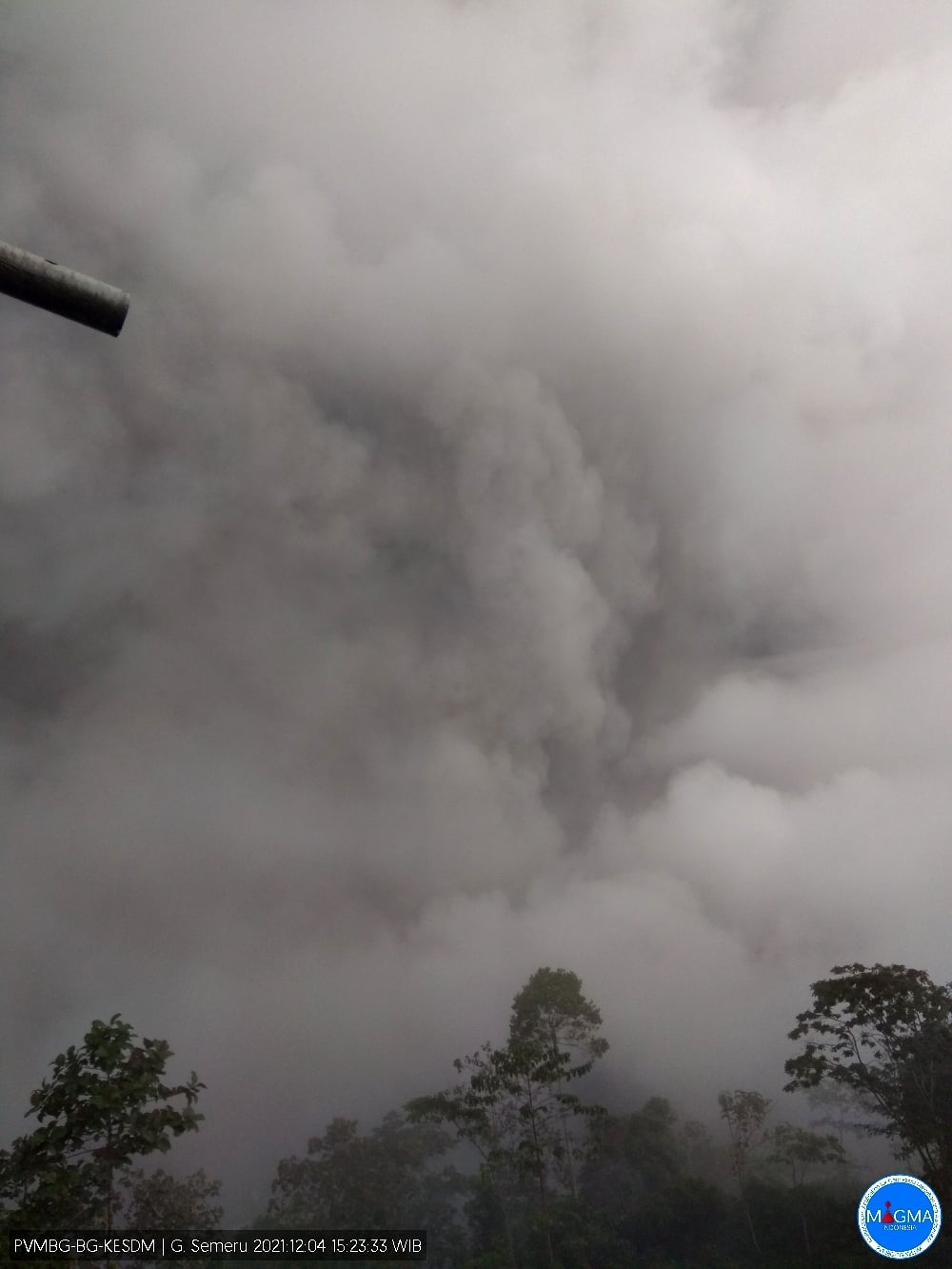
At around 11:00 a.m. on 12/04, VAAC Darwin issued a VONA message this morning regarding volcanic ash emissions from the Semeru volcano in Indonesia. An ash cloud rose to an altitude of 15,200 m. Further information is still awaited from the PVMBG.
Videos on social networks show people fleeing a pyroclastic flow that has almost reached the villages south of the volcano. It is not yet known whether there are any casualties.
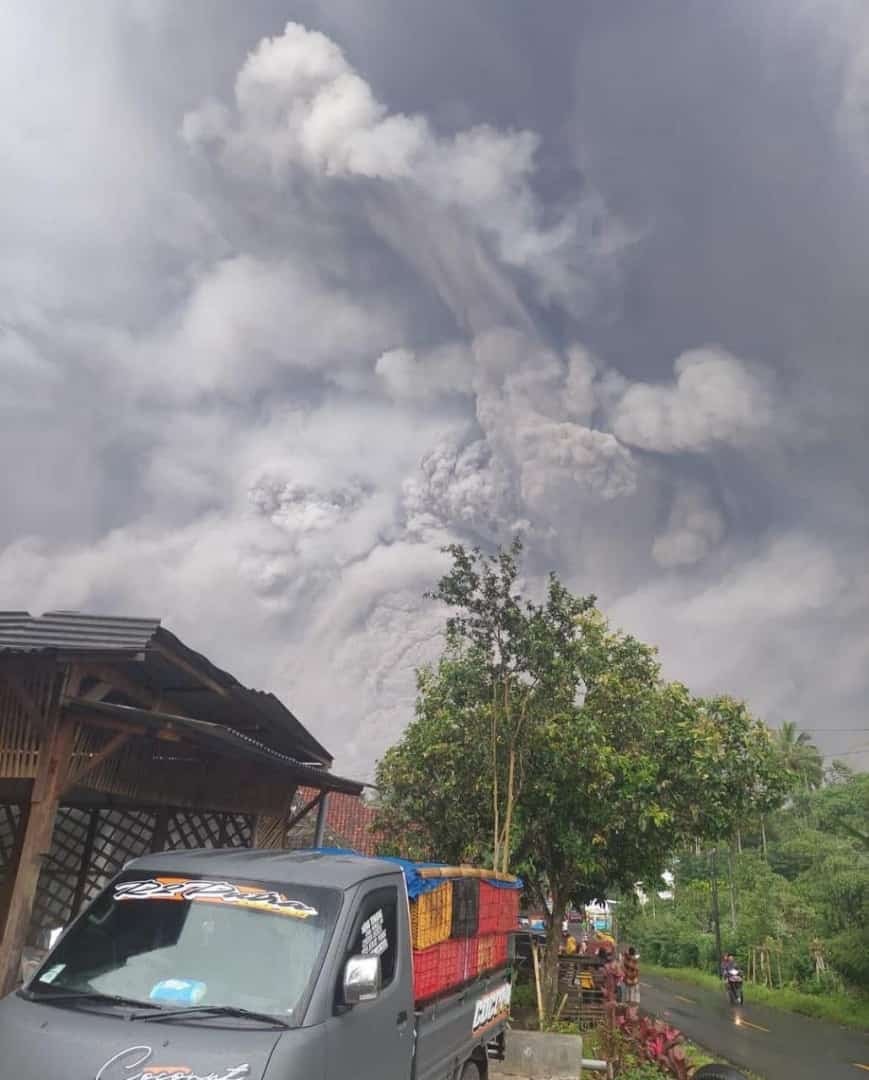
Indonesia’s Semeru volcano in east Java erupted at 3:00 a.m. local time on Saturday, blanketing its surroundings in a thick layer of smoke and ash and prompting thousands to flee their homes. No casualties have yet been identified, according to the national agency for natural disasters. However, the emergency services had to evacuate residents as pyroclastic flows reached their villages and destroyed a bridge in the Lumajang region.
Surveillance data:
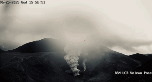
1. Visual: From November 1 to 30, 2021, the volcano is clearly visible until it is covered with fog. The gas bursts observed from the main crater are white and gray with moderate to high thickness about 100-600 meters from the summit. Eruptions still occur continuously, producing gray eruption columns with a maximum height of 300 to 600 m above the top of the crater.
On December 1, 2021, there was an avalanche of hot clouds with a sliding distance of 1700 m from the summit, or 700 m from the front of the lava flow, with a southeast direction. After the hot cloud avalanche appeared, a lava avalanche occurred with a distance and sliding direction that were not observed. On December 4, 2021 from 1:30 p.m. WIB flood vibrations were recorded, then at 2:50 p.m. WIB hot clouds were observed to descend with a sliding distance of 4 km from the summit or 2 km from the end of the flow. lava to the southeast (Besuk Kobokan), but so far the distribution and distance of the avalanches cannot be determined.
2. Seismicity: The number and types of earthquakes recorded from November 1 to 30, 2021 are dominated by surface earthquakes in the form of eruption earthquakes with an average of 50 events per day, and Avalanche earthquakes on December 1 and 3, 2021, each occurring 4 times. Volcanic earthquakes (deep volcanic earthquakes, shallow volcanic earthquakes, and tremors) that indicate the rise of magma to the surface are recorded in very low amounts.
Analysis: Visual observations showed that the occurrence of lava avalanches and hot cloud avalanches was caused by the instability of the lava tongue deposits. The activity that occurs on December 1 and 4 is surface activity (secondary eruption). Seismicity does not indicate an increase in the number and type of earthquakes associated with bringing fresh magma / rock to the surface.
National Disaster Mitigation Agency spokesperson Abdul Muhari said at least 13 villagers died from severe burns and 57 were hospitalized, 16 of them critically with burns. He added that rescuers were still looking for seven residents and sand miners along a river in the village of Curah Kobokan who were reported missing.
Sources : VAAC DArwin , Lalibre .be , Asahi.com
Photo : Edi Kurniawan , Magma Indonesie.
Video : chave weather – daily videos
Italy / Sicily , Etna :
04 December 2021, 09:55 (08:55 UTC). Communication on the activity of ETNA.
The National Institute of Geophysics and Volcanology, Osservatorio Etneo reports that sporadic and diluted ash emissions from the Southeast Crater are observed. Due to cloud cover, observations are made discontinuously. The phenomenon was detected both by surveillance cameras and by INGV-OE staff.
From the seismic point of view, the tremor increases slightly on the average values. The infrasound activity is at low levels and does not show significant changes.
GNSS and inclinometric monitoring networks for soil deformation do not show significant variations.

04 December 2021, 17:29 (16:29 UTC).
The National Institute of Geophysics and Volcanology, Osservatorio Etneo, reports that Strombolian activity is observed in the Southeast Crater from 4:10 p.m. GMT.
From the seismic point of view, the gradual increase in the amplitude of the tremor continues. An increase in infrasound activity is also observed from 3 p.m.
Further updates will be communicated shortly.
Source : INGV.
Photo : Boris Behncke.
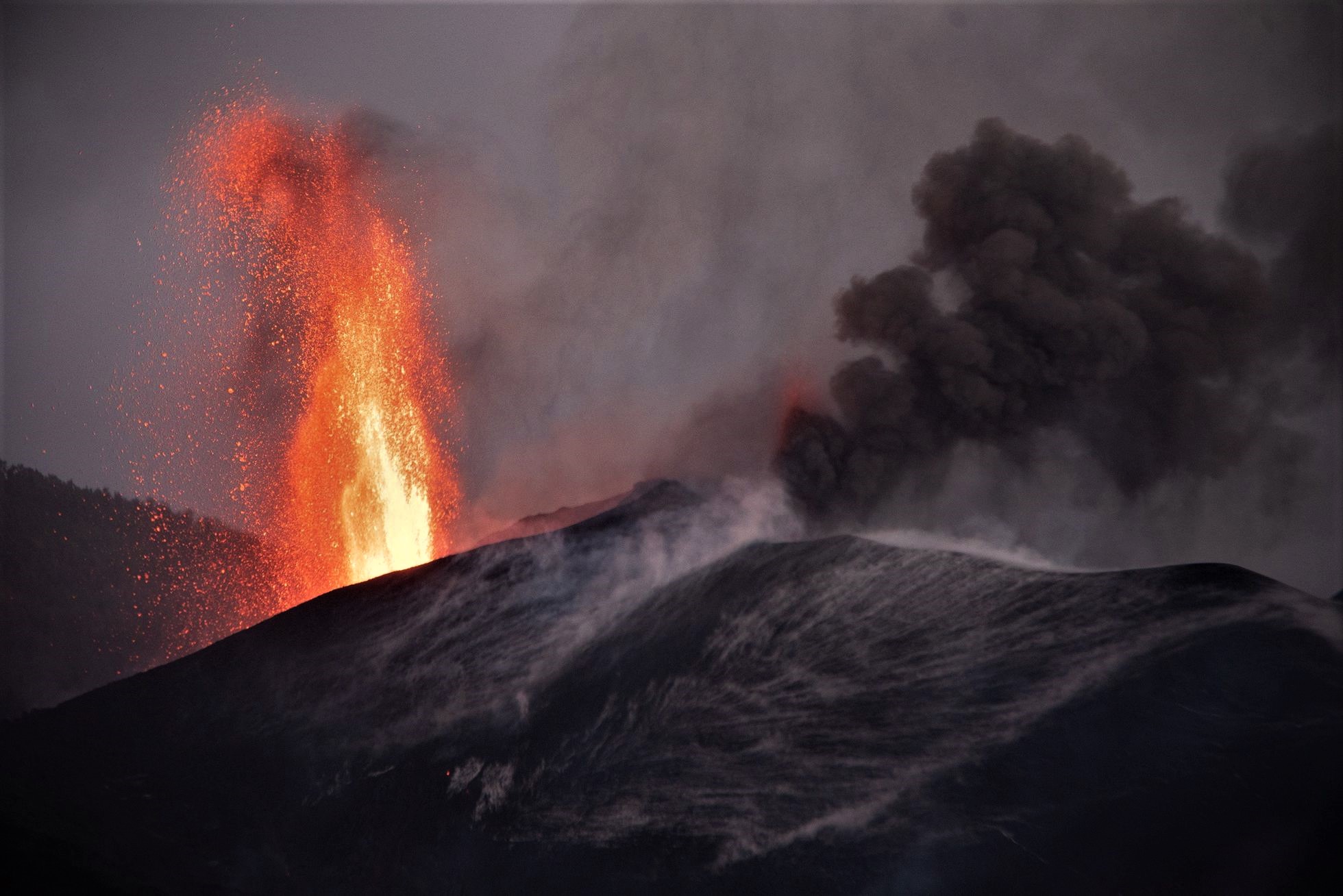
Spain / La Palma , Cumbre Vieja :
04 December 2021 10:00 UTC. Eruptive activity continues on La Palma.
Since the last declaration, a total of 37 earthquakes have been located in the area affected by the volcanic reactivation on the island of La Palma, including 1 felt by the population.
Seismicity continues below the central area of Cumbre Vieja in the same areas of the previous days, 31 of these earthquakes are located at depths of 9-18 km and only 6 at depths of around 20 km.
The maximum recorded magnitude is 3.4 (mbLg) corresponding to today’s earthquake at 1:23 UTC, with a depth of 26 km.
The amplitude of the tremor signal is maintained at low levels.
The island’s network of permanent GNSS stations shows an elevation reversal recorded on December 2 at station LP03, which is closest to the eruptive centers.
In the rest of the stations, the slight deflation possibly linked to the deep seismicity has stabilized, except in LP01 which continues to record it.
In view of the image calibrated at 08:45 UTC, a degassing cloud height of 1,500 m is estimated.
The height of the cone is measured by obtaining a value of 1,124 m at sea level .

The National Geographical Institute (IGN) has recorded since last midnight 14 small earthquakes in La Palma, the largest of magnitude 3.4, located in the municipality of Fuencaliente at 1:23 and at a depth of 26 kilometers. The latest report from the National Security Directorate (DSN) indicates that there has been a decrease in intermediate and deep seismicity over the past day. In addition, a new lava flow emerged from one of the old emitting foci on Friday afternoon and is heading southwest towards the Las Manchas region, according to spokespersons for the Emergency Plan for the volcanic risk (Pevolca). The new lava tongue occupies areas already occupied by previous flows.
Source : IGN es , El Pais .
Photo : Miguel Calero / El Pais , I love the world .
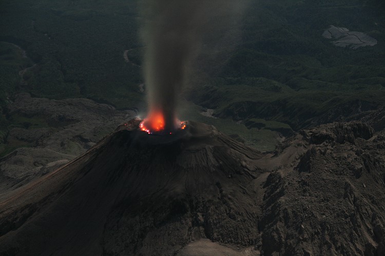
Indonesia , Merapi :
Merapi activity report from November 26 to December 2, 2021.
– The weather around Mount Merapi is generally sunny in the morning and evening, while it is foggy in the afternoon.
– On December 1, 2021, there were 2 hot cloud avalanches towards the southwest with a maximum slide distance estimated at 3,000 m. Light ash rains were reported in the East-South-East area of Mount Merapi, namely Mriyan, Sangup Tamansari Boyolali and Gedongijo Klaten.
– Lava avalanches were observed 170 times towards the southwest with a maximum sliding distance of 2000 m.
– We observe that there is a decrease in the height of the southwest dome of about 2 m, while the morphology of the central lava dome is not observed to have a significant change. The volume of the southwest lava dome is 1,615,000 m3 and the central dome is 2,948,000 m3.

– The intensity of the seismicity this week is higher than last week.
– 144 avalanche earthquakes
– 1 multi-phase earthquake
– 1 shallow volcanic earthquake
– 1 distant tectonic earthquake
The deformation of Mount Merapi, which was monitored using EDM this week, showed a distance shortening rate of 0.7 cm / day.
– There is a rainfall intensity of 83 mm / hour for 225 minutes at Kaliurang station on November 30, 2021. An increase in flow and lahars was reported in the Woro, Gendol, Kuning, Boyong and Bebeng rivers on December 1 2021.
Conclusion:
– The volcanic activity of Mount Merapi is still quite high in the form of effusive eruption activity. The status of the activity is defined in the “SIAGA” level.
– The current potential danger consists of lava avalanches and hot clouds in the South-East-South-West sector over a maximum of 3 km to the Woro river and 5 km to the Gendol and Kuning rivers , Boyong, Bedog, Krasak, Bebeng and Putih. During this time, the ejection of volcanic material in the event of an explosive eruption can reach a radius of 3 km from the summit.
Source : BPPTKG.
Photo : Oystein Lund Andersen .
Guatemala , Santiaguito :
Activity:
The observatory of the Santiaguito volcano OVSAN reports a white degassing at the level of the crater which disperses in a southwest direction. Weak and moderate explosions were recorded which expel white and gray columns at a height of 3,400 meters above sea level (11,155 feet) which are scattered in the southwest and west direction. Strong avalanches of boulders and ash continue to be generated on the flanks: West, South-West and South mainly and others weak to moderate in the direction North-West, North-East and South-East, some reaching the base of the Dome Caliente.
Some explosions and avalanches leave fine ash suspended in the volcanic perimeter. A slight degassing noise similar to that of an airplane turbine can be heard due to the pressure of the magmatic gases. Due to the extrusion of block lava in the dome of the Caliente Dome in a West-South-West direction and unstable materials in the crater, there is a probability of moderate to heavy pyroclastic flows, so do not stay at near or within the canals. rivers near the slopes of the volcano.
Source : Insivumeh.
Photo : Marc Szeglat , 2009 , wikimedia