November 03 , 2021 .
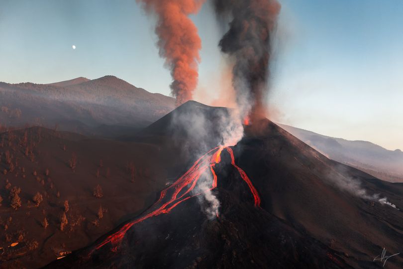
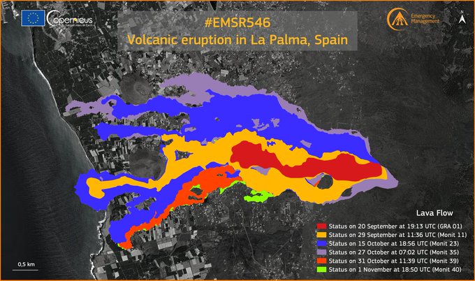
Spain / La Palma , Cumbre Vieja :
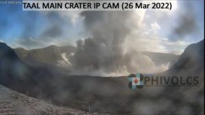
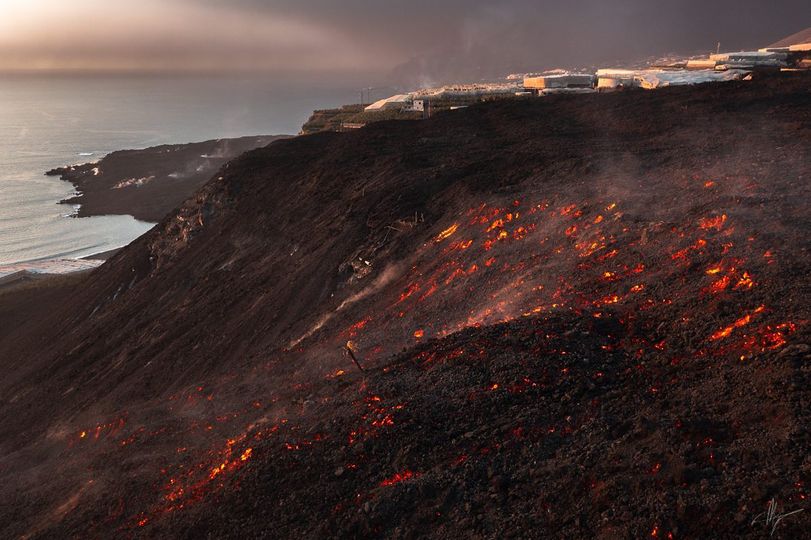
November 02, 2021, 09:00 UTC. Eruptive activity continues on La Palma:
Since the last declaration, 152 earthquakes have been located in the area affected by the volcanic reactivation of Cumbre Vieja, 18 of these earthquakes were felt by the population, having reached maximum intensity in the epicentral zone IV (EMS98 ) with three earthquakes. The biggest earthquake is the one that occurred yesterday at 8:24 p.m. (UTC), with a magnitude of 4.6 mbLg at a depth of 36 km.
Eight earthquakes were located at depths of about 30 km, the rest of the hypocenters of the period are located at a shallower depth of about 12 km.
The amplitude of the volcanic tremor signal remains at high average levels, with few intensifying pulses.
The island’s network of permanent GNSS stations does not show a clear tendency to warp from the stations closest to the eruptive centers, while at the more distant stations a slight deflation has persisted, possibly related to a deep seismicity.
The geochemical observations are compatible with the eruptive dynamics. The deformation and the contribution of magmatic gases are correlated.
In view of the calibrated image, an ash cloud of 3,700 m is estimated at 07:45 UTC in an easterly direction.
The most notable current eruptive phenomenon continues to be the emission of a considerable volume of ash covering the entire west-northwest sector of the island, accompanied by short episodes with audible explosions. This episode can be caused by intense degassing.
The dispersion of ash and sulfur dioxide is mainly East-South-East. This represents an unfavorable scenario over the next 36 hours for the operation of La Palma airport and for the airspace between La Palma, La Gomera and the west of Tenerife.
Seismicity continues to be localized, mainly, at depths between 10 and 15 km. Earthquakes located at depths greater than 20 km are also recorded. The maximum magnitude was 4.6 mbLg from an earthquake on Monday at 8:24 p.m. at a depth of 36 km.
The government of the Canary Islands has reported that the air quality in the municipalities of Tazacorte, Los Llanos de Aridane and El Paso is « extremely unfavorable » due to airborne particles emitted by the Cumbre Vieja volcano. The authorities recommend that the population reduce all outdoor activities and use « adequate protection for work that must be done outdoors. »
The ash cloud from the volcano eruption is also affecting the operation of La Palma airport and Tenerife North airport. In the latter case, there have already been eight hijackings and eight cancellations.
Sources : IGNes , El Pais.
Photos : Van Marty
Carte : Copernicus
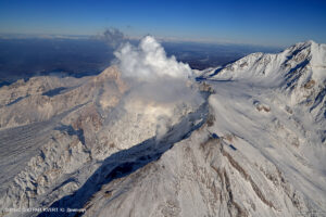
Peru , Sabancaya :
Analysis period: from October 25, 2021 to November 01, 2021, Arequipa, November 02, 2021.
Alert level: ORANGE
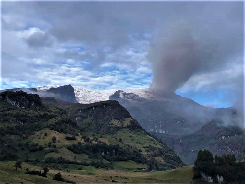
The Geophysical Institute of Peru (IGP) reports that the eruptive activity of the Sabancaya volcano remains at moderate levels, that is to say with the recording of an average of 50 explosions daily, with columns of ash and of gas up to an altitude of 3.0 km above the summit of the volcano and their consequent dispersion. Therefore, for the following days, no significant change is expected in eruptive activity.
The IGP recorded and analyzed the occurrence of 1,289 earthquakes of volcanic origin, associated with the circulation of magmatic fluids within the Sabancaya volcano. An average of 50 explosions was recorded daily. During this period, Volcano-Tectonic (VT) earthquakes associated with rock fractures were located mainly in the Northwest, Northeast and North of Sabancaya and presented magnitudes between M 2.0 and M 4.0.

The monitoring of the deformation of the volcanic structure using GNSS techniques (processed with fast orbits) does not present any significant anomalies. However, in general, an inflation process was observed in the northern sector (around the Hualca Hualca volcano). Visual surveillance made it possible to identify columns of gas and ash up to 3.0 km altitude above the summit of the volcano, which were scattered towards the South-East, East, North, North-East and North – West of Sabancaya. Satellite recordings have identified the presence of 9 thermal anomalies (maximum value of 16 MW) associated with the presence of a lava body on the surface of the volcano’s crater.
RECOMMENDATIONS
• Keep the volcanic alert level in orange.
• Do not approach within a radius of 12 km from the crater.
Source : IGP.
Photo : Ingemmet.
Colombia , Nevado del Ruiz :
Weekly activity bulletin of the Nevado del Ruiz volcano.
The activity level continues at: Yellow activity level or (III): Changes in the behavior of volcanic activity.
Regarding the monitoring of the activity of the Nevado del Ruiz volcano, the SERVICIO GEOLÓGICO COLOMBIANO reports that:
The seismicity linked to the dynamics of the fluids inside the volcanic conduits presented an increase in the number of recorded earthquakes and the seismic energy released compared to the previous week. This seismic activity was characterized by the appearance of continuous volcanic tremor, tremor pulses, earthquakes of long types and very long periods, which exhibited varying energy levels and spectral content. These earthquakes were located mainly in the Arenas crater. Some of these signals were associated with ash emissions, confirmed by the cameras installed in the area of the volcano and by the report of the officials of the Los Nevados National Natural Park and the Colombian Geological Survey.
The seismicity generated by rock fracturing has decreased in number of earthquakes and in seismic energy released compared to the previous week. This seismic activity was located mainly in the South-West, South-South-West, North-West, North-East and East sectors of the volcano, as well as in the Arenas crater. The depths of the earthquakes ranged from 0.3 to 6.2 km. The maximum magnitude recorded during the week was 1.7 ML (local magnitude) corresponding to the earthquake recorded on October 27 at 5:16 p.m. (local time), located 9.6 km northwest of the Arenas crater, at 6, 2 km deep.
There were several episodes of low energy drumbeat type seismicity associated with the fracturing of the rock on October 26 and 27. This seismicity has been linked to the processes
of ascent, location-growth and evolution of a lava dome at the bottom of the Arenas crater.
The deformation of the volcanic surface, measured from GNSS (Global Navigation Satellite System) stations and electronic inclinometers, continued to show minor changes.
Source : SGC
Photo : Ramirez Jorge.
Iceland , Torfajökull :
Long period, low frequency earthquake activity increases in Torfajökull volcano .
Around 10:00 UTC on 31-October-2021 the earthquake activity of long period and low frequency earthquakes increased in the morning in Torfajökull volcano. The current swarm now seems to be coming from the glacier part of the caldera, the earlier activity seems to have taken part some place in north part of the Torfajökull volcano caldera. Location of the this earthquake activity is difficult if not impossible because of the type of earthquake activity being generated in Torfajökull volcano.
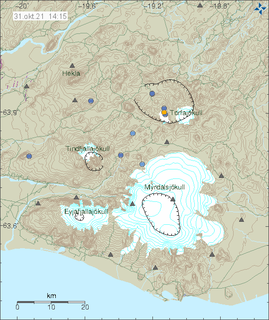
The volcano system of Torfajökull volcano north of Mýrdalsfjökull glacier. With few dots in it showing few poorly located earthquakes.
The located earthquake activity in Torfajökull volcano. Copyright of this image belongs to Icelandic Met Office.
The situation is difficult to figure out just by looking at seismometer data. Icelandic Met Office is going to make a flyover today with the help of Icelandic Coast guard and try and see what is going on in Torfajökull volcano. Last eruption in Torfajökull volcano was in the year 1477 .
Source : icelandgeology.net
Italy , Campi Flegrei :
Weekly bulletin from October 25, 2021 to October 31, 2021. (Issue date November 02, 2021)
SUMMARY STATEMENT OF ACTIVITY
In view of the monitoring data, it is highlighted:
1) SEISMOLOGY: In the week of October 25 to 31, 2021, 70 low energy earthquakes were recorded in the Campi Flegrei region (Mdmax = 0.9 ± 0.3).
2) DEFORMATIONS: The average value of the lifting speed in the zone of maximum deformation from mid-July 2021 is approximately 10 ± 2 mm / month, a decrease compared to the value of approximately 13 ± 2 mm / month previously recorded since September 2020. The elevation recorded at the RITE GPS station is approximately 81 cm since January 2011.
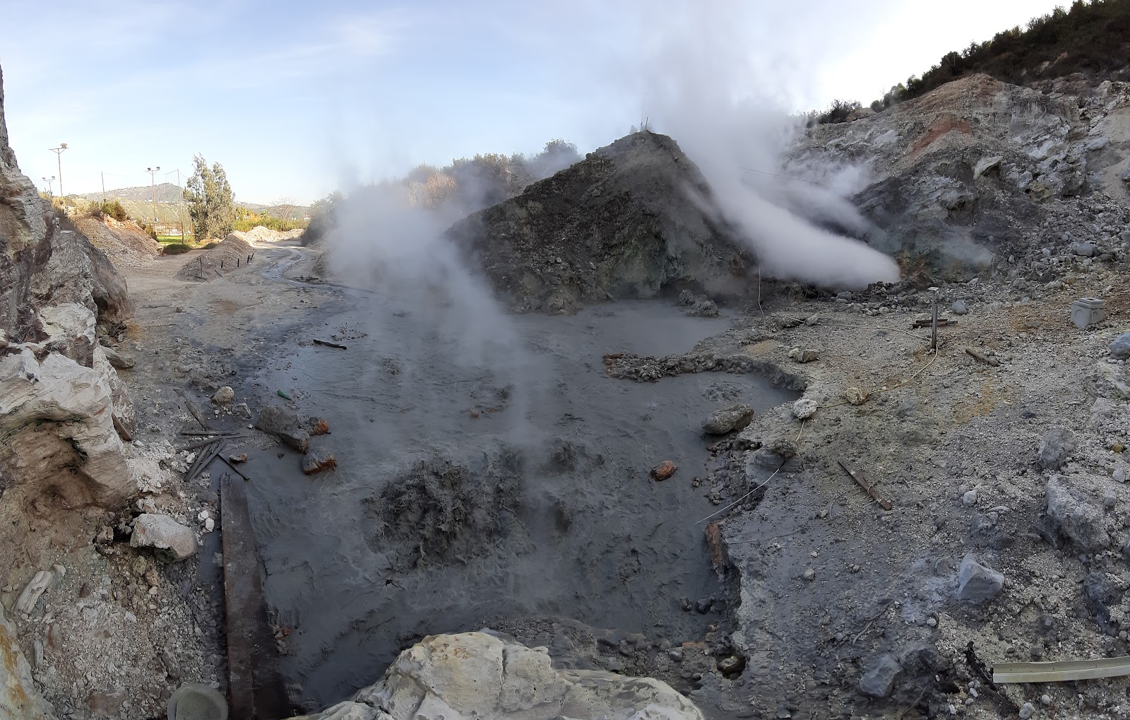
3) GEOCHEMISTRY: The soil CO2 fluxes measured last week did not show any significant changes. The temperature sensor installed in a fumarolic emission at 5 meters
of the main fumarole from Pisciarelli showed an average value of ~ 95 ° C
SOIL DEFORMATIONS
GPS. The average value of the lifting speed in the zone of maximum deformation since mid-July 2021 is approximately 10 ± 2 mm / month, down from the value of approximately 13 ± 2 mm / month recorded previously since September 2020. The elevation recorded at the RITE GPS station is approximately 81 cm since January 2011, of which approximately 32 cm since January 2019.
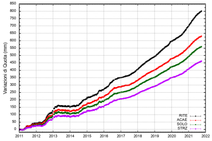
Figure 4.1 shows the time series of elevation changes of some GPS stations located in the maximum deformation zone of the Phlegraean Fields.
The dots in black, red, green and purple represent the weekly variations calculated with the final IGS products (ephemeris and precise parameters of the Earth’s rotation) which are released with a delay of 12-18 days.
Source : INGV
Read the article : https://www.ov.ingv.it/index.php/bollettini/bollettini-di-monitoraggio/bollettini/settimanali-dei-campi-flegrei/anno-2021/1006-bollettino-flegrei-2021-11-02/file
Graphique : INGV
Photo : Pisciarelli , Tullio Ricci, dicembre 2019