October 13 , 2021.
Italy / Sicily , Etna :
Weekly Bulletin from October 04, 2021 to October 10, 2021, (issue date October 12, 2021)
SUMMARY STATEMENT OF ACTIVITY
In view of the monitoring data, it is highlighted:
1) VOLCANOLOGICAL OBSERVATIONS: Degassing activity of summit craters
2) SEISMOLOGY: low seismic activity of fracturing, amplitude of stationary volcanic tremor at low levels
3) INFRASOUND: overall low infrasound activity
4) DEFORMATIONS: The soil deformation monitoring networks do not show significant variations.

5) GEOCHEMISTRY: The flow of SO2 at an average level
The flux of CO2 emitted by soils is at medium-high values.
The partial pressure of CO2 dissolved in water shows no significant change.
There is no update on the helium isotope ratio (the latest data from 9/21/2021 was at medium-high values).
There are no updates for the C / S report.
6) SATELLITE OBSERVATIONS: The thermal activity in the summit area was at a low level.
VOLCANOLOGICAL OBSERVATIONS
During the week, the monitoring of the volcanic activity of Etna was carried out through the analysis of images from the surveillance cameras of the INGV, Osservatorio Etneo (INGV-OE) and through an inspection carried out on October 4, 2021 in the summit area by INGV staff. Due to the cloud cover that characterized most of the week, the observation of volcanic activity from the cameras was almost discontinuous.
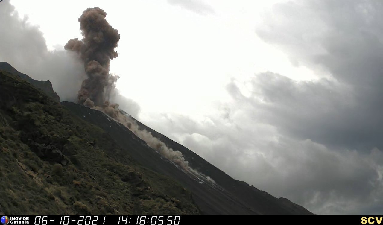
Overall, the activity of Etna during the week was characterized by degassing activities of varying nature from all the summit craters.
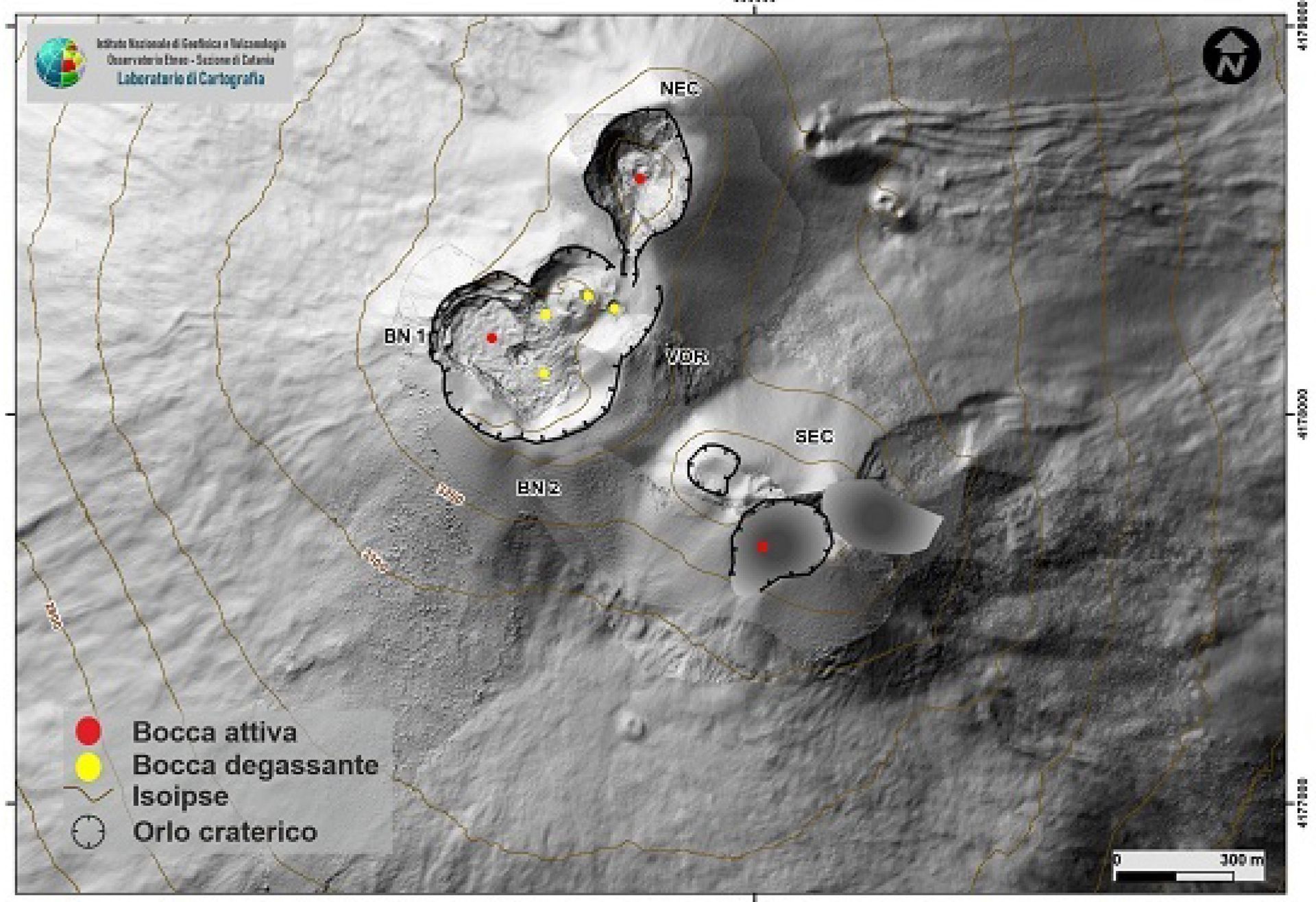
Fig. 3.1 – Map of the summit craters of Etna, morphological update of the SEC carried out following the drone and GPS campaign of October 4, 2021. The topographic reference base, on which the morphological updates are superimposed, is the DEM 2014 prepared by Aerogeofisica Laboratoire – Rome Section 2. The dots indicate the degassing vents and the fumaroles.
In particular, the degassing was mainly carried out by the crater of Bocca Nuova (BN), which fed a pulsed and almost continuous degassing regime. The South-East crater (SEC) was characterized by a continuous degassing of the fumaroles located on the eastern edge, while from the North-East crater (NEC) and the Voragine crater (VOR), it was observed ordinary degassing and fumarolic degassing respectively.
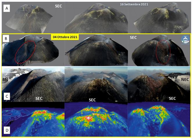
In addition, on October 4, 2021, an inspection was carried out in the summit area during observations of the craters with drones equipped with visible and thermal cameras. In figure 3.3, the 3D models of the Southeast crater obtained from the calculations are compared by photogrammetry. The comparison between the two DEMs shows a deepening of the South-West and East edges of the South-East crater identified by the red ellipse in figure 3.3 B. In addition, it is possible to observe the details of the edge of the South-East crater. Is characterized by some anomalies in correspondence with fumaroles
Source : INGV.
Photos : Gio Giusa , INGV.
Hawaii , Kilauea :
19°25’16 » N 155°17’13 » W,
Summit Elevation 4091 ft (1247 m)
Current Volcano Alert Level: WATCH
Current Aviation Color Code: ORANGE
Activity Summary:
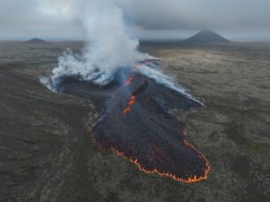
Kīlauea volcano is erupting. As of this morning, October 12, 2021, lava continues to erupt from a single vent in the western wall of Halemaʻumaʻu crater. All lava activity is confined within Halemaʻumaʻu crater in Hawai‘i Volcanoes National Park. Seismicity and volcanic gas emission rates remain elevated.
Summit Observations:
Sulfur dioxide (SO2) emission rates remain high, with a measured emission rate of approximately 2,500 tonnes per day on October 11, 2021, slightly lower than the past few days. Summit tilt has changed to a slightly inflationary trend since the morning of October 10.

This magnified view of the West Fissure inside Halema’uma’u Crater at the top of Kīlauea was captured on October 11, 2021, through the lens of a laser rangefinder. A prominent horseshoe-shaped splash cone, measured 28 m (92 ft) above the adjacent lava lake, surrounds a bubbling lava pond that also sometimes hosts taller fountains. HVO scientists observed multiple collapses of the cone splash plating in the pond every few minutes; these collapses appeared to have no effect on the eruptive activity of the fissure.
Halemaʻumaʻu Lava Lake Observations:
Lava continues to erupt from a single vent in the western wall of Halemaʻumaʻu crater. The western end of the lake showed a maximum elevation of approximately 783 meters (2569 ft) above sea level when measured by field crews on October 11, which is a 2 meter (7 ft) increase over the past day and a total increase of about 40 meters (131 ft) since lava emerged on September 29. The total erupted volume since the beginning of the eruption was estimated to be about 15.9 million cubic meters (4.2 billion gallons) on October 8. The western vent changed eruptive style from sustained fountain heights of 4 m (13 ft) to more variable heights -up to 35 meters (115 ft) – observed by field crews on October 11. The fountain has built a spatter cone with an approximately 10 meter (33 ft) wide opening facing east towards the lake. Lava is flowing into the lake through the spatter cone opening. The central island and several of the smaller eastern islets from the 2020 lava lake are still above the lake surface along with an island of the 2020 western vent rampart in the northwest part of the lake. The lava lake is not level across its surface due to the location of the vent in the western end. Areas closer to the vent are about 2-4 meters (7-13 ft) higher in elevation compared to the north and south part of the lake and 8 meters (26 ft) higher than the east end of the lava lake. Lava surface activity such as crustal foundering is seen on the western end of the lake and north and south of the central island but is no longer observed on the east end of the lake.
Source : HVO.
Photo : USGS / M. Zoeller.
Spain / La Palma , Cumbre Vieja :
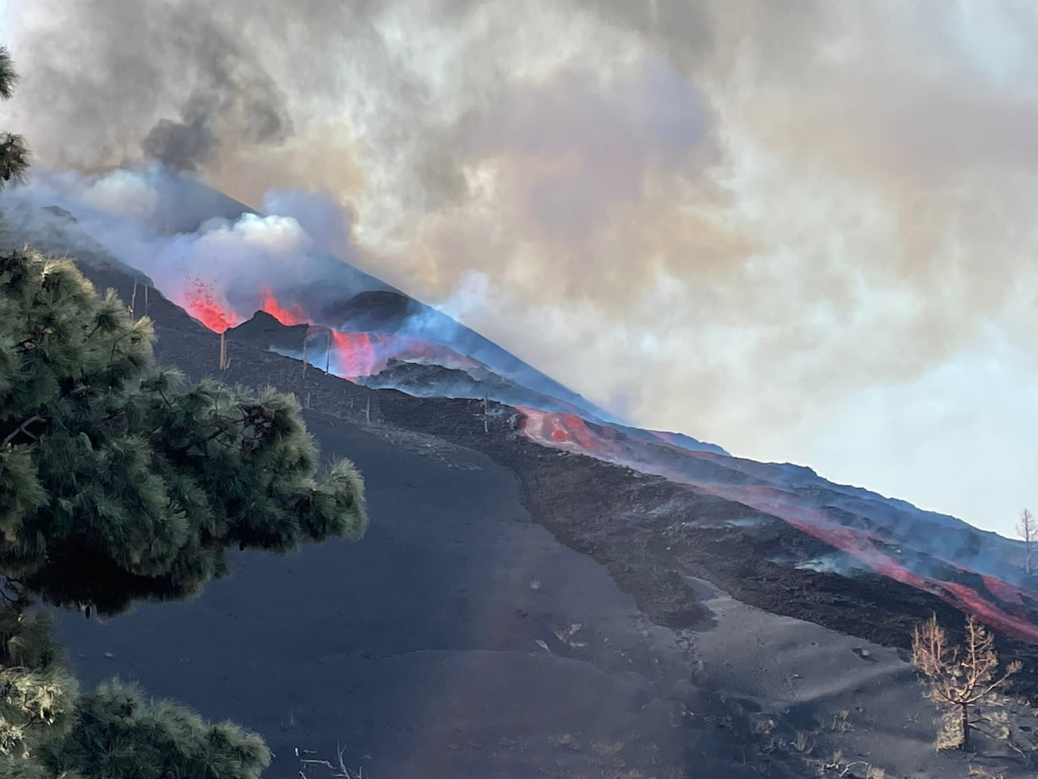
12 October 2021 10:00. UTC Eruptive activity continues on La Palma.
Since the last press release, 64 earthquakes have been located in the area affected by the volcanic reactivation of Cumbre Vieja; 6 of these earthquakes were felt by the population, the maximum intensity being in epicentral zone IV (EMS98) during an earthquake that occurred at 07:16 UTC on the 12th, with a magnitude of 3.9 (mbLg) at 12 km depth. .
The earthquake that occurred on the 12th at 7:25 am, with a magnitude of 4.1 mbLg and 37 km deep, is the largest of the period considered.
Among the earthquakes located in this period, 4 are at depths greater than 30 km, the rest of the hypocenters are located at a shallower depth, about 12 km.
The average amplitude of the volcanic tremor increased compared to the average value of the observations measured during this eruption.
The height of the eruptive column measured at 6.30 UTC is 3,500 m.
The island’s network of permanent GNSS stations shows stability at stations close to eruptive centers.
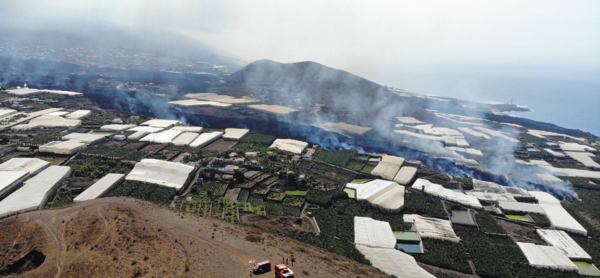
Miguel Angel Morcuende, technical director of Pevolca (Canary Islands Volcanic Emergency Plan), said on Monday that there was little chance that there would be a new emitting center near the volcanic cone. Technicians came to this conclusion because the average depth of earthquakes is between 10 and 15 kilometers deep. Authorities on Tuesday ordered the evacuation of 700 to 800 inhabitants from several population centers of La Laguna, in Los Llanos de Aridane, in the face of the advancing lava flow that is moving the most northwest and its proximity with the limit zone of the exclusion perimeter. The increase in the lava input after the collapse of the north face of the cone and the great fluidity of the flows of the Cumbre Vieja volcano brought the affected area to 595 hectares, according to the latest report from the Department of Homeland Security (DSN ).
As long as this eruptive channel is open, it is very unlikely that another volcano will open, at most there would be another mouth at a distance of not more than 500m from the volcano, exceptionally 1 km, but no more.
Now, the deep seismic-volcanic swarm we are experiencing is releasing a lot of energy with magnitude 4+ events and this indicates a pressurized magmatic system wants to leave, so in principle it would do it through the easiest place. , the channel that is already there, open. So a new volcano will NOT open as long as the eruption continues.
Now, if this eruption stops or stops for some reason, then we would move on to another scenario, that of 1949, where for 18 days it stopped and then moved back to Nambroque. If the same thing happens and the eruption stops, then yes the magma will try to come out again and then there are two options whether it comes out of the same point or opens a new one. The odds are 80% through the existing conduit and 20% otherwise.
The eruption will continue, and it is to be hoped that for the good of all it will calm down in the coming days … even if for the moment it still does not show signs of real weakness, only small indications.
Source : IGN. El Pais , Volcanes y Ciencia Hoy.
Photos : Patrick Allard / via Marc Szeglat ( volcanoes and volcanism) , Volcanes y Ciencia Hoy .
Italy , Stromboli :
Weekly Bulletin from October 04, 2021 to October 10, 2021, (issue date October 12, 2021)
SUMMARY STATEMENT OF ACTIVITY
In view of the monitoring data, it is highlighted:
1) SUMMARY STATEMENT OF ACTIVITY:
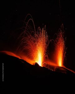
During this period a normal explosive activity of Strombolian type was observed, interrupted on October 6 by a major explosion. The total hourly frequency of explosions fluctuated between medium-low and medium values (8-15 events / h).
The intensity of the explosions was low in the North crater area and variable from low to high in the Center-South area.
2) SEISMOLOGY: The monitored seismological parameters do not show significant changes except for the explosion greater than 06/10.
3) DEFORMATIONS: The soil deformation monitoring networks do not show any significant variation.
4) GEOCHEMISTRY: The flow of SO2 at a medium-low level
The flow of CO2 emitted by the ground on the Pizzo Sopra la Fossa is at medium-high levels.
The weekly average C / S ratio is at medium-high values (C / S = 8.81).
The value of the isotopic ratio of Helium dissolved in the thermal aquifer of Stromboli (October 05) is at high values.
5) SATELLITE OBSERVATIONS: The thermal activity in the summit area is at a low level.
VOLCANOLOGICAL OBSERVATIONS
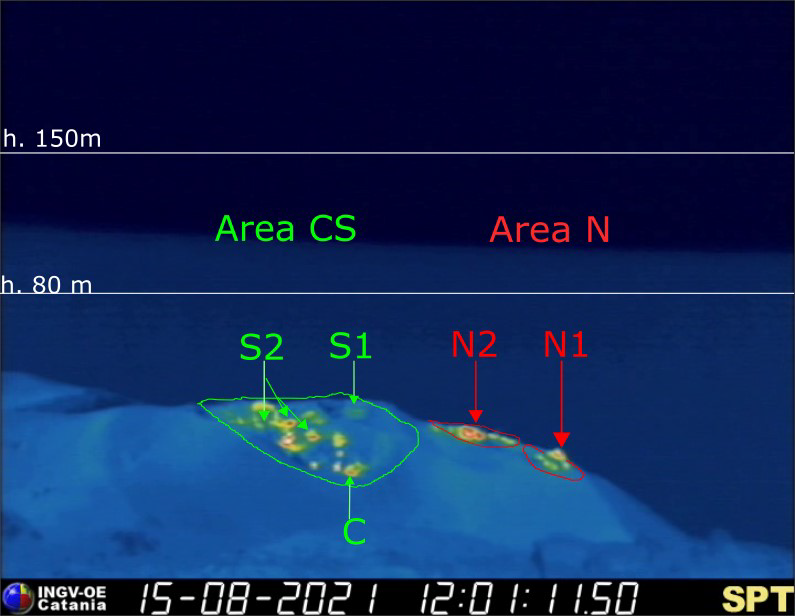
During the observation period, the eruptive activity of Stromboli was characterized thanks to the analysis of the images recorded by the surveillance cameras of the INGV-OE (altitude 190m, Punta Corvi, altitude 400m and Pizzo). The explosive activity was mainly produced by 3 (three) eruptive chimneys located in the North crater area and by 6 (six) eruptive chimneys located in the Center-South crater area. All the vents are placed inside the depression which occupies the terrace of the crater (Fig. 3.1). Due to adverse weather conditions, visibility from the crater terrace on October 7 was insufficient for a correct description of the explosive activity.
A major explosive event occurred on October 6, 2021 from the northern area of the crater terrace.
Description of eruptive activity by surveillance cameras:
The N1 crater located in the North zone, with two emission points, produced low intensity explosions, mainly (less than 80 m in height) emitting fine materials (ash) mixed with coarse materials (lapilli and bombs) . Vent N2, with two emission points, showed low intensity explosive activity (less than 80 m in height) emitting coarse matter interrupted by the explosive event of October 6, 2021. The average frequency of the explosions oscillated between 3 and 8 events / h.
In the Center-South zone, sector S1 sporadically showed low-intensity explosive activity, emitting fine matter, while the three vents located in sector S2 produced explosions, even simultaneously, of varying intensity, from low to high. (the products of some explosions exceeded 150 m in height) emitting coarse matter mixed with fine materials. Sector C produced intense degassing activity. The frequency of the explosions varied from 4 to 8 events / h.

Description of the major explosive event of October 6, 2021:
On October 6, 2021, a major event affected the mouths of the northern area of the crater terrace. In detail, the explosive event started at 14:17:44 UTC from the vents located in sector N2 of the North zone. The projections showed a radial distribution with a distribution of pyroclasts beyond the crater terrace and in large numbers in the area of Pizzo sopra la Fossa, and rolling profusely in the upper part of the Sciara creating a thick blanket of ash. The launch of ballistic projections lasted about ten seconds followed by an ash plume lasting about 20 s.
Source : INGV.
Photos : INGV.
Chile , Nevados de Chillan :
Special Report on Volcanic Activity (REAV), Ñuble region, Nevados de Chillán volcanic complex, October 12, 2021, 6:10 p.m. local time (Continental Chile).
The National Service of Geology and Mines of Chile (Sernageomin) publishes the following PRELIMINARY information, obtained thanks to the monitoring equipment of the National Volcanic Monitoring Network (RNVV), processed and analyzed at the Volcanological Observatory of the Southern Andes ( Ovdas):
On Tuesday, October 12, 2021, at 5:35 p.m. local time (8:35 p.m. UTC), the monitoring stations installed near the Nevados de Chillán volcanic complex recorded an earthquake associated with fluid dynamics (long period type) in the volcanic system.

The characteristics of earthquakes after their analysis are as follows:
TIME OF ORIGIN: 5:35 p.m. local time (8:35 p.m. UTC)
LATITUDE: 36.854 ° S
LONGITUDE: 71.372 ° W
DEPTH: 2.3 km
REDUCED DISPLACEMENT: 530 (cm2)
ACOUSTIC SIGNAL: 11.3 pascals (Pa) reduced to 1 km
The characteristics of the surface activity are as follows:
MAXIMUM HEIGHT OF THE COLUMN: 320 meters above the point of emission
DISPERSAL DIRECTION: South
OBSERVATIONS:
The volcanic technical alert remains at the Yellow level.
Source : Sernageomin.
Photo : Webcam.
Iceland , Askja :
OCTOBER 12, 2021 : Inflation and earthquake activity in Askja volcano
Inflation has been increasing in Askja volcano over the last few weeks. According to latest news that inflation is now at 14 cm, since the inflation was detected at the end of August. On Saturday 9-October-2021 an earthquake with magnitude of Mw3,2 was detected in Askja volcano. This is was the strongest earthquake in Askja volcano in the last 20 years according to the news.
Askja is remote and there are no or limited amounts of web cameras in the area. With winter arriving going there is impossible for most people. If an eruption happens this winter the best view is probably going to be harmonic tremor data until pictures appears from Icelandic Met Office or someone with an air plane (if the weather allows for that).
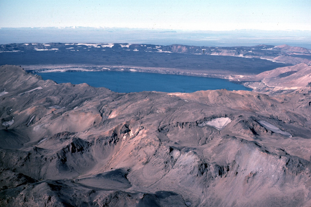
Askja is a central volcano made up of the Dyngjufjöll massif and at least three calderas, the largest of which is 8 km wide. This view from the SE looks across Öskjuvatn lake within the youngest caldera that formed in 1875 during Askja’s largest historical eruption. It truncates a larger caldera, whose wall is seen in the distance above the lava-covered caldera floor. The 100-km-long Askja fissure swarm, which includes the Sveinagjá graben, is also related to the Askja volcanic system.
Askja is a large basaltic central volcano that forms the Dyngjufjöll massif. It is truncated by three overlapping calderas, the largest of which is 8 km wide and may have been produced primarily from subglacial ring-fracture eruptions rather than by subsidence. A major rhyolitic explosive eruption from Dyngjufjöll about 10,000 years ago was in part associated with the formation of Askja caldera. Many postglacial eruptions also occurred along the ring-fracture. A major explosive eruption on the SE caldera margin in 1875 was one of Iceland’s largest during historical time. It resulted in the formation of a smaller 4.5-km-wide caldera, now filled by Öskjuvatn lake, that truncates the rim of the larger central caldera. The 100-km-long Askja fissure swarm, which includes the Sveinagja graben, is also related to the Askja volcanic system, as are several small shield volcanoes such as Kollatadyngja. Twentieth-century eruptions have produced lava flows from vents located mostly near Öskjuvatn lake.
Source : icelandgeology.net, GVP.
Photo : Michael Ryan, 1984 (U.S. Geological Survey).