July 11 , 2023.
Iceland , Reykjanes Peninsula :
Evidence of ground deformation southwest of Keilir . Five days since the onset of the seismic sequence between Fagradalsfjall and Keilir
Updated 9. July 2023 at 6:30pm
Today marks 5 days since the onset of the seismic sequence between Fagradalsfjall and Keilir caused by a magmatic intrusion just north-east of the location of the 2022 dike intrusion that resulted in an eruption 5 days later.
Deformation in the area continues to slow down and seismicity is relatively quiet around the dike location.
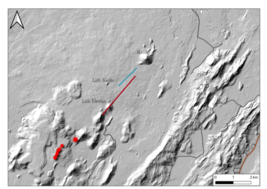
Modeled location and extent of surface deformation related to fault movement, based on the July 7-8 ICEYE interferogram (blue) and the modeled location of the dyke intrusion (red). The eruptive vents of 2021 and 2022 are represented by red stars. Topography by IslandsDEM and roads from the National Land Survey of Iceland. Dyke and fault locations mapped by Michelle M. Parks, Vincent Drouin, Icelandic Meteorological Office; Ásta Rut Hjartardóttir, University of Iceland.
Triggered seismicity northeast of Keilir and in the region between Keilir and Kleifarvatn continued with earthquakes at Kleifarvatn last night (8 July) the largest being magtnitude 4.6. It was widely felt in the Southwest region, in particular due to its closer proximity to the capital region than the dike location. Rockfall was reported in mountains by Kleifarvatn and Trölladyngja, including some rockfall on nearby roads.
A one-day ICEYE interferogram, spanning the 7-8 July 2023, constrains the location of the dike related deformation as of yesterday afternoon. The interferogram shows deformation related to continued inflow of magma into the dike as well as significant surface deformation related to movements on NE-SW trending faults and possible graben formation.
Geodetic modeling results based on the new ICEYE interferogram show that the magma continues to reach shallower depths, now estimated to be at half a kilometer below the surface. The modeling indicates that as of yesterday afternoon, the dike was not propagating further to the north or south, but remained at a relatively stationary location between Litli Keilir and Litli Hrútur, with a length of approximately 3 km. However, the dike continues to inflate and migrate upwards.
These measurements and modeling results indicate that magma is moving closer to the surface, with an eruption being a highly likely scenario, although the timing is still uncertain (hours to days).
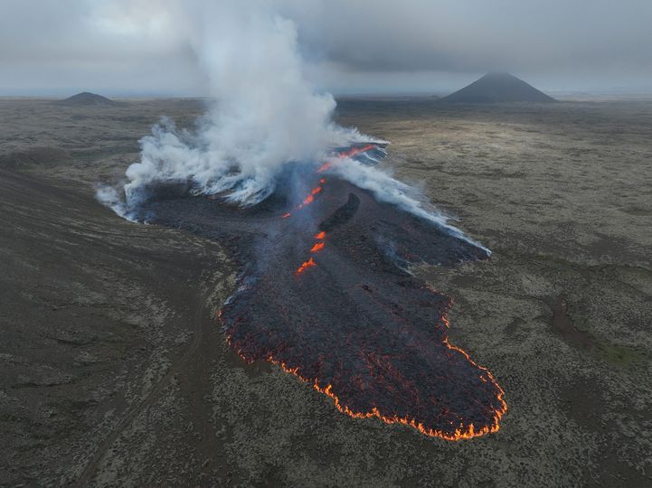
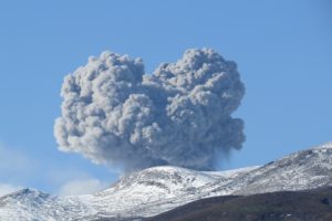
An eruption has started just northwest of Litli Hrutur
A volcanic eruption started near Litli Hrútur on Reykjanes peninsula today 10. July at 16:40. The fissure is around 200 meters long. Gas pollution is likely widely in Reykjanes and the Capital Area. Travellers are advised not to enter the area until responders have had a chance to evaluate conditions. Gas pollution close to the eruption can be dangerous.
Last night a M 5.2 earthquake was detected just ESE of Mount Keilir. This event is the largest one in the current seismic activity. Aftershocks are very likely and can reach up to M4.
Since July 4th, over 1200 earthquakes have been detected between Fagradalsfjall and Keilir. The current swarm is caused by a dike intrusion beneath the area.
Care should be taken by steep slopes where rockfall can occur following strong quakes.
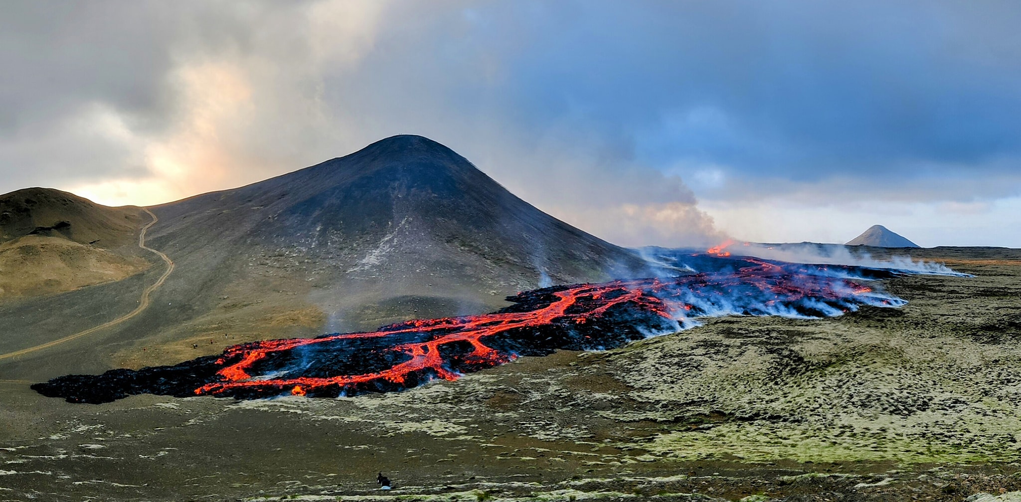
Minor volcanic eruption on the Reykjanes Peninula . Seven days since the onset of the seismic sequence between Fagradalsfjall and Keilir
Updated 10. July 2023 at 6:30pm

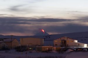
At 16:40 today, 10 July, a minor volcanic eruption began close to Litli Hrútur in Reykjanes Peninsula, situated between Fagradalsfjall and Keilir mountains. The eruption is small and there is presently no emission of ash to the atmosphere. From first estimates, there is a 200-m-long fissure oriented approximately northeast-southwest on the eastern and northeastern slopes of Litli Hrútur from which lava is emerging as a series of fountains. At the time of writing, the eruption is occurring in a small depression and lava is flowing to the south, while gas and steam emissions are drifting to the northwest. The eruption is in an uninhabited region, so there are no immediate risks to communities or infrastructure. The development of the eruption is presently unclear, so we advise the public not to attempt to visit the eruption area. Dangerously high levels of volcanic gases will accumulate close to the eruption. Further updates from IMO will be issued in the coming days.
During the prelude to the eruption, IMO scientists became aware of increasing levels of tremor at a seismic station at Fagradalsfjall. Episodes of heightened tremor occurred on 8 and 9 July, and again today in the hours before the eruption broke the surface. Similar periods of tremor were noted just ahead of similar eruptions on the Reykjanes Peninsula in 2021 and 2022.
Source : IMO
Photos : IMO , Daníel Páll Jónasson , Jakob Vegerfors , Benedikt Gunnar Ófeigsson.
La Réunion , Piton de la Fournaise :
Press release from the Paris Institute of Earth Physics, Piton de la Fournaise Volcanological Observatory, July 10, 2023 – 12:30 p.m. – 8:30 a.m. UTC.
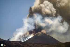
Ongoing eruption
The eruption started on 02/07/2023, around 08:30 local time continues. The amplitude of the volcanic tremor (indicator of an emission of lava and gas on the surface) fluctuates over time on the scale of a few hours with phases of continuous tremor and phases of intermittent tremor, but remains low compared to at the start of the eruption. This is reflected at the level of the eruptive site by fluctuations in activity, with projections of lava fountains at the level of the more or less intense eruptive cone.
Lava flow estimates established by satellite method on the HOTVOLC platform (OPGC – Clermont Auvergne University) over the past 24 hours indicated flows between 1.5 and 13 m3 / sec. Given the cloud mass regularly present on the eruptive site as well as the presence of lava tunnels, these flows may be underestimated.
The active volcanic cone – located southeast of the Enclos Fouqué at an altitude of 1720 m – continues to build by accumulating lava projections.
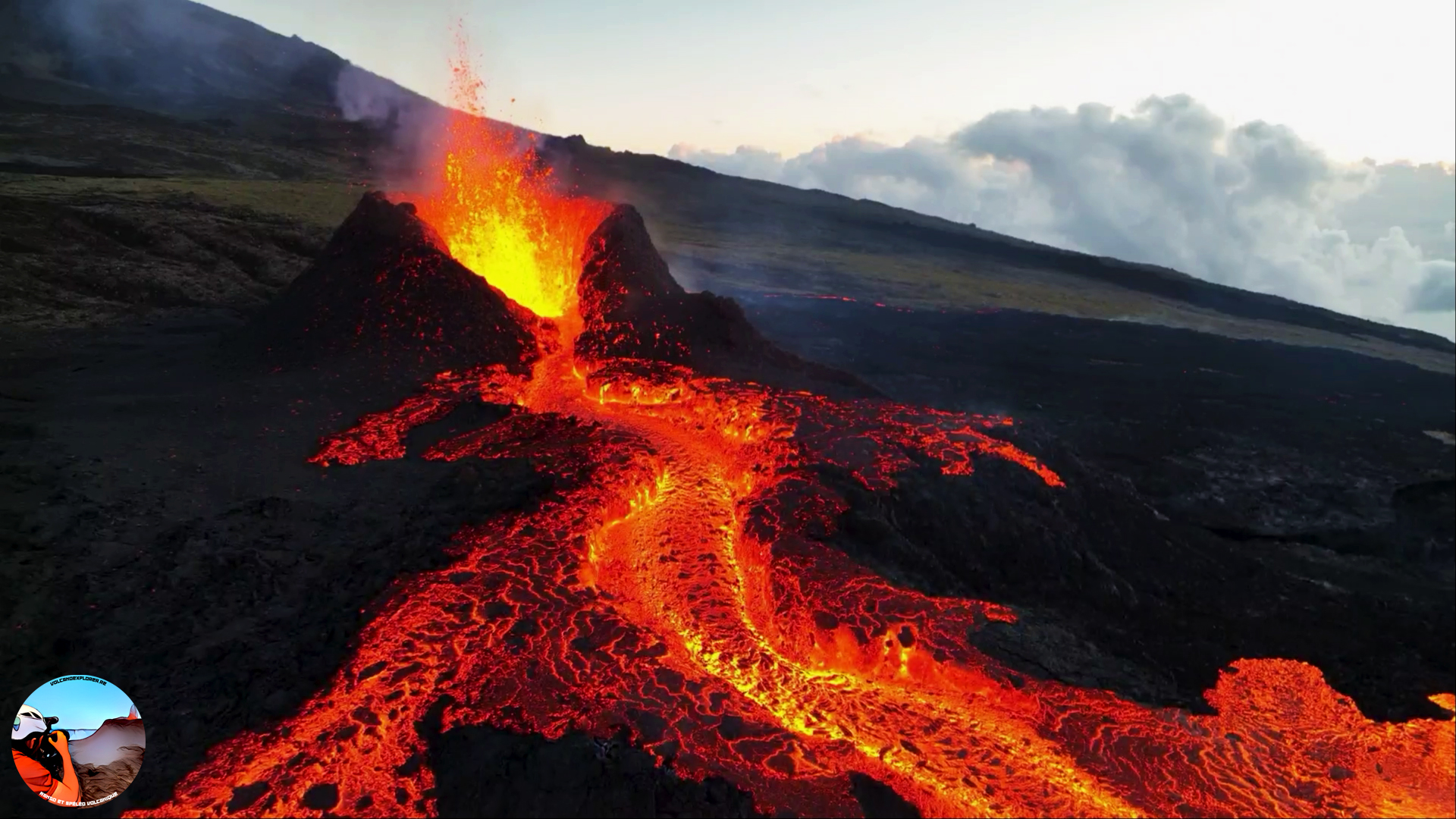
The flow of the lava now takes place partly in a lava tunnel in the immediate vicinity of the cone under construction, even if flows are still visible. Last night the active flows were still at altitudes above 1300 m at the top of the Grandes Pentes. The flow front has not changed since July 5 and is still 1.8 km from the road.
At present, no significant deformation of the building is recorded.
Seismic activity is still recorded under the summit area but it remains weak compared to the start of the eruption. Thus over the last 24 hours, 4 superficial volcano-tectonic earthquakes have been recorded. This reduction leads to a reduction in the risk of the appearance of a new crack and/or collapse in the crater, but does not mean that it can be excluded.
Alert level: Alert 2-1 (eruption in the Enclosure without any particular threat to the safety of people, property or the environment).
Source : OVPF
Photo : Volcanoexplorer.re Tunnels de lave Réunion.
Philippines , Mayon :
MAYON VOLCANO BULLETIN 11 July 2023 8:00 AM
In the past 24-hour period, thirty-eight (38) pyroclastic density currents (PDCs), five hundred eleven (511) rockfall events and three (3) volcanic earthquakes were recorded by the Mayon Volcano Network. The PDCs were generated by partial collapses from the summit lava dome and the advancing front and margins of lava flows and travelled one to three minutes within four kilometers of the Basud, Mi-isi and Bonga Gulleys. Thin ashfall was reported in some areas of Brgy. Mabinit, Legazpi City, Brgy. Budiao and Brgy. Salvacion, Daraga, and Camalig, Albay. Very slow effusion of lava from the summit crater continued to feed lava flows and collapse debris on the Mi-isi and Bonga gullies as well as rockfall and PDCs on these and the Basud (eastern) Gullies. The lava flows have advanced to approximate lengths of two thousand eight hundred (2800) meters and one thousand four hundred (1400) meters along Mi-isi and Bonga gullies, respectively, from the summit crater while collapse debris has deposited to four thousand (4000) meters from the crater along the Basud channel.
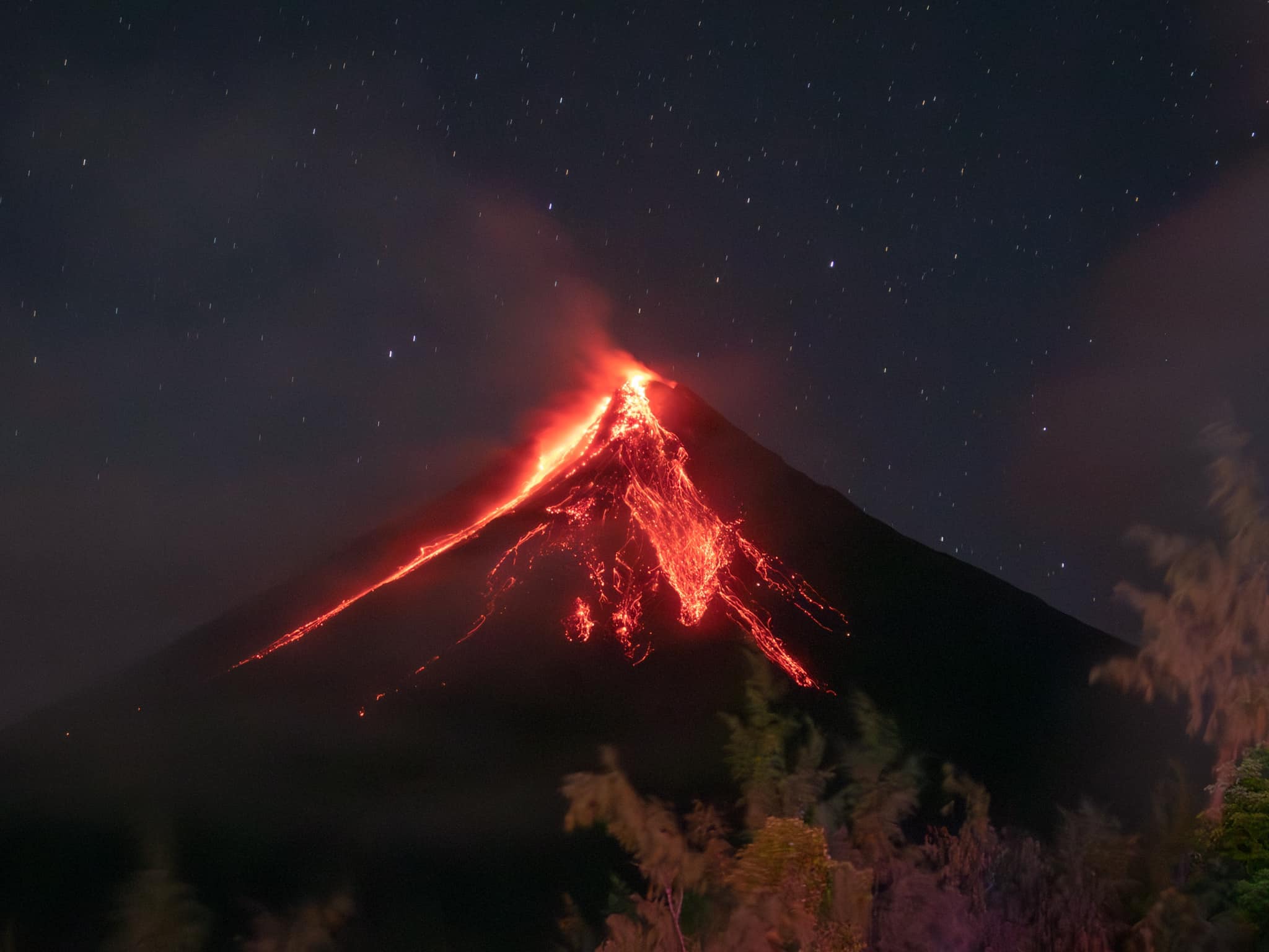
Continuous moderate degassing from the summit crater produced steam-laden plumes that rose 800 meters before drifting to the southwest and south-southwest. Sulfur dioxide (SO2) emission averaged 721 tonnes/day on 10 July 2023. Short-term observations from EDM and electronic tiltmeter monitoring show the upper slopes to be inflating since February 2023. Longer-term ground deformation parameters based on EDM, precise leveling, continuous GPS, and electronic tilt monitoring indicate that Mayon is still inflated, especially on the northwest and southeast.
Alert Level 3 is maintained over Mayon Volcano, which means that it is currently in a relatively high level of unrest and hazardous eruption within weeks or even days could still be possible.
Source : Phivolcs
Photo : Rick Estillomo.
Indonesia , Karangetang :
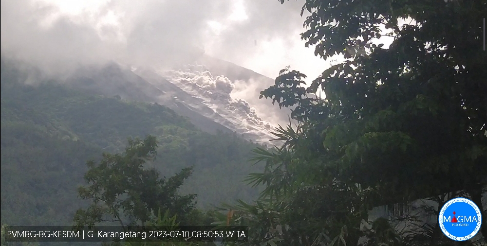
An eruption of G. Karangetang occurred on Monday, July 10, 2023, at 08:50 WITA. The height of the eruption column was not observed. The eruption was recorded on a seismograph with a maximum amplitude of 20 mm and a duration of 205 seconds.
VOLCANO OBSERVATORY NOTICE FOR AVIATION – VONA
Issued : July 10 , 2023.
Volcano : Karangetang (267020)
Current Aviation Colour Code : ORANGE
Previous Aviation Colour Code : orange
Source : Karangetang Volcano Observatory
Notice Number : 2023KAR002
Volcano Location : N 02 deg 46 min 48 sec E 125 deg 24 min 22 sec
Area : North Sulawesi, Indonesia
Summit Elevation : 5709 FT (1784 M)
Volcanic Activity Summary :
Eruption at 00h50 UTC (08h50 local).
Volcanic Cloud Height :
Ash-cloud is not observed.
Other Volcanic Cloud Information :
Ash-cloud is not observed.
Remarks :
Eruption recorded on seismogram with maximum amplitude 20 mm and maximum duration 205 second.
Source et photo : Magma Indonésie.
Chile , Laguna del Maule :
Seismology
The seismological activity of the period was characterized by the recording of:
426 VT-type seismic events, associated with rock fracturing (Volcano-Tectonics). The most energetic earthquake presented a Local Magnitude (ML) value equal to 2.4, located 7.5 km south-south-east of the lagoon, at a depth of 8.5 km in reference to the height average of the lagoon.
13 LP-type seismic events, associated with fluid dynamics within the volcanic system (Long Period). The size of the largest earthquake assessed from the Reduced Displacement (DR) parameter was equal to 17.8 cm2.
Geodesy
The geodetic activity of the period was characterized by:
– Monitoring lines with average rates similar to historical values, observed in the volcanic complex, adjusting a maximum of 1.73 cm / month.
– The maximum vertical rate of change occurs at station MAU2, reaching 1.81 cm/month.
– Horizontal strain rates similar to previous periods, with some minor variations.
Due to the above, it is concluded that the historically observed inflationary process on the complex continues in values adjusted to the usual averages. VT activity continues to be recorded, although with a lower level of occurrence and energy than those recorded in previous periods. The seismic activity is located in two privileged sources, located to the South-West and to the East of the lagoon. The process of volcanic deformation continues with rates similar to those observed historically. Superficially, no obvious change related to volcanic activity is observed. Although the seismic process has gradually reduced its energy, it is still above what is considered its basic threshold. Consequently, it is determined to maintain its technical alert in yellow and a possible assignment radius of 2 km measured from the CO2 anomaly zone.
YELLOW TECHNICAL ALERT: Changes in the behavior of volcanic activity.
Source : Sernageomin
Photo : Cegemar