October 02 , 2021.
Spain / La Palma , Cumbre Vieja :
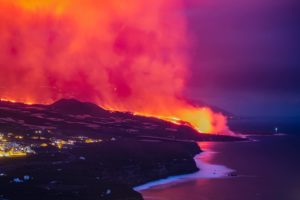
Lava emanating from the Cumbre Vieja volcano in La Palma has already gained 19 hectares over the sea, according to the latest update from the European Copernicus Earth Surveillance Satellite Monitoring System, with data collected early this Friday morning. The delta created by the main flow is already 50 meters high and 320 meters wide. The eruption caused the opening of a new mouth with two new lava flows, which, according to the forecasts, would take place North of the current one, according to the data of the CSIC, very stuck to the current one, towards Los Llanos de Aridane, the most populous municipality on the island. Some areas of this town, where around 20,000 people lived, have already been evacuated and razed to the ground by the magma, as is the case in Todoque. The concentration of sulfur dioxide in the air rose on Friday in parts of La Palma, although this does not pose a health risk, says the management of the Canary Islands Volcanic Emergency Plan (Pevolca).
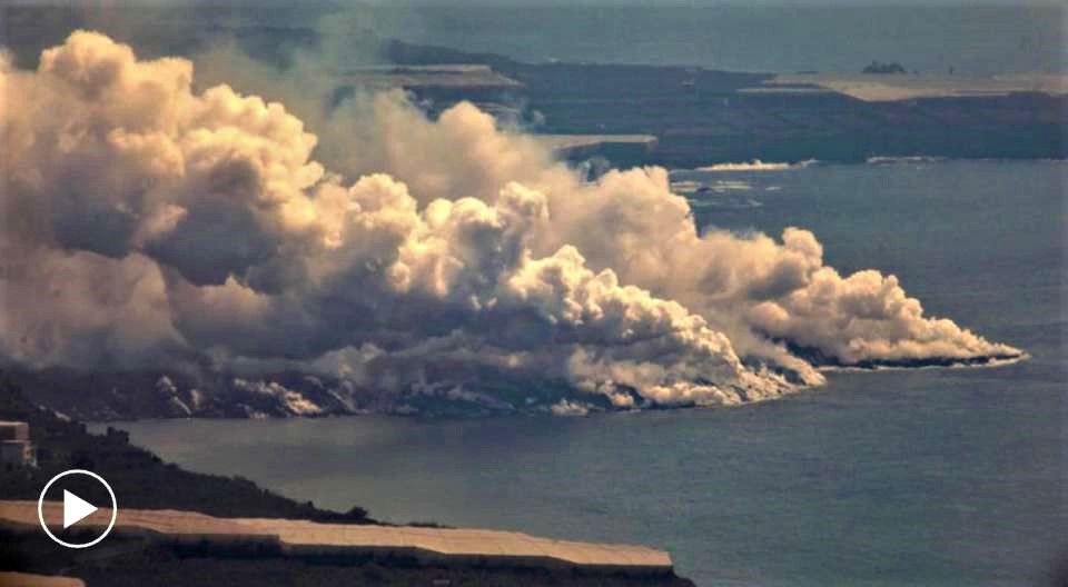
The Cumbre Vieja volcano has already emitted 80 million cubic meters of lava. This lava volume is about twice that of the Teneguía eruption in 1971, in a third of the time. The new mouth, as sources at the National Geographic Institute confirmed on Friday morning, became the third emission center of the new volcano, which is in addition to the crater and the mouth that opened at the end of last week and which is the one which contributes the most to the flow which reaches the sea. The new mouth is very effusive, that is to say very liquid. If a new flow is confirmed, everything indicates that it is heading north of the current one, according to CSIC data.
01 October 2021, 12:00 UTC. Eruptive activity continues on La Palma Since the last declaration, a total of 12 earthquakes have been located in the southern area of La Palma, close to the ongoing volcanic eruption. As in previous days, the hypocenters are located between 10 and 14 km deep in the same area where the reactivation began on September 11. Two of the earthquakes were felt by the population, the most important of them with a maximum intensity of III in the epicentral zone and corresponding to an earthquake of magnitude 3.5 mbLg at 20:30 UTC yesterday. The average amplitude of the volcanic tremor remained stable yesterday morning within a range of average values for this eruption. From 18 UTC yesterday, it started to gradually increase until it reached values similar to those it reached during the first two days of the eruption (September 19-20). The island’s network of permanent GNSS stations is showing a return to strain stability.
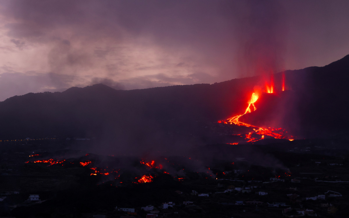
The volcano of La Palma is increasing its activity. Two new flows separated from each other by just 15 meters emerged early this Friday morning from the Cumbre Vieja volcano. It is a new double mouth, reported Friday sources from the Geological and Mining Institute of Spain (IGME), located about 450 meters north of the crater. The lava they emit is very effusive (liquid) and has gained ground in a westerly direction.
The news emissions were observed by members of the Military Emergency Unit (EMU) and IGME itself. “At 2:30 am on October 1, there were two new flows, which occupied two ravines and are heading west,” explains geologist Raul Perez of the Geological and Mining Institute of Spain, who was on Thursday evening a few hundred yards away when the new mouth appeared. “The question is whether they will converge with the main casting,” notes Perez.
Sources : El Pais , IGN.
Photos : IGN / El Pais. Aristegui Noticias .
Hawaii , Kilauea :
19°25’16 » N 155°17’13 » W,
Summit Elevation 4091 ft (1247 m)
Current Volcano Alert Level: WARNING
Current Aviation Color Code: RED
Activity Summary:
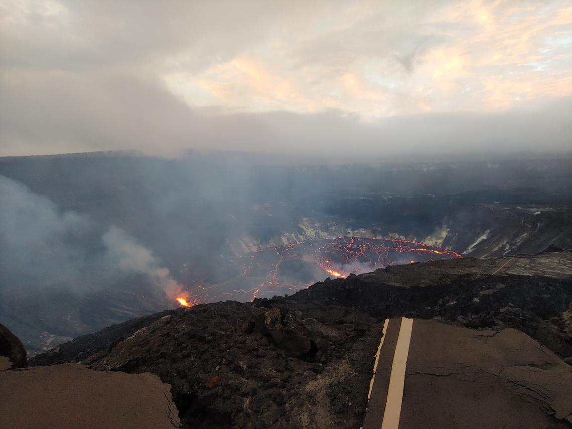
Kīlauea volcano is erupting. Lava continues to erupt from multiple vents along the floor and western wall of Halemaʻumaʻu crater. As of the morning of October 1, 2021, all lava activity is confined within Halemaʻumaʻu, in Hawai’i Volcanoes National Park. Seismicity and volcanic gas emission rates remain elevated.
On the evening of September 30, 2021, the new eruption in Halema’uma’u at Kīlauea summit continued with several active vents in the middle of the lake and on the west side. USGS image by K. Lynn.
Summit Observations:
Sulfur dioxide (SO2) emission rates remain high and were estimated at around 20,000 tonnes per day the morning of September 30, 2021. This is significantly lower than the initial emission rates of 85,000 tonnes per day that were measured just after the eruption started on the afternoon of September 29, 2021. Seismicity is stable, with few earthquakes and ongoing eruptive tremor. Summit tiltmeters continued to record slowing deflationary tilt through the last 24 hours.
Halemaʻumaʻu Lava Lake Observations:
Lava continues to erupt from multiple vents on the base and west wall of Halemaʻumaʻu, though the number of active fountaining locations has decreased over the past day. The rate of lava lake rise has slowed since the early phase of the eruption. Over the past 24 hours, the lava lake surface has risen approximately 4 meters (4.4 yds). In total, the lava lake surface has risen approximately 24 m (26 yds) since the eruption started. Localized and discontinuous crustal foundering continues (a process by which cool lava crust on the surface of the lava lake is overridden by less-dense liquid from below causing the crust to sink into the underlying lake lava). Last night, field crews reported maximum fountain heights of 15 m (49 ft) at the dominant vent on the west wall of Halemaʻumaʻu. Low fountaining continues at other sources, which are less vigorous.
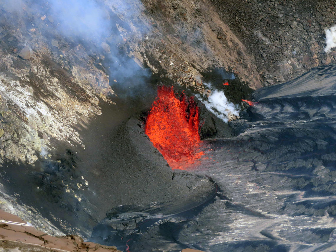
This telephoto image shows two vents that formed on the western wall of Halema‘uma‘u crater during the current eruption of Kīlauea, which began on September 29, 2021. The photo was taken from the southern rim of Halema‘uma‘u crater at 9:02 a.m. HST on Oct. 1, 2021, in an area of Hawai‘i Volcanoes National Park that remains closed to the public due to safety reasons.
East Rift Zone Observations:
No unusual activity has been noted in the Kīlauea East Rift Zone. Ground deformation motion suggests that the upper East Rift Zone—between the summit and Puʻuʻōʻo—has been steadily refilling with magma over the past year. SO2 and hydrogen sulfide (H2S) emissions from Puʻuʻōʻō were below instrumental detection levels when last measured on January 7, 2021.
Source : HVO
Photos : USGS / K. Lynn. USGS / J.M. Chang.
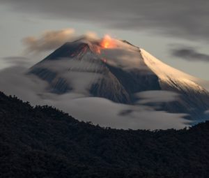
Indonesia , Merapi :
Mount Merapi activity report from September 24 to 30, 2021
RESULTS OF OBSERVATIONS
Visual
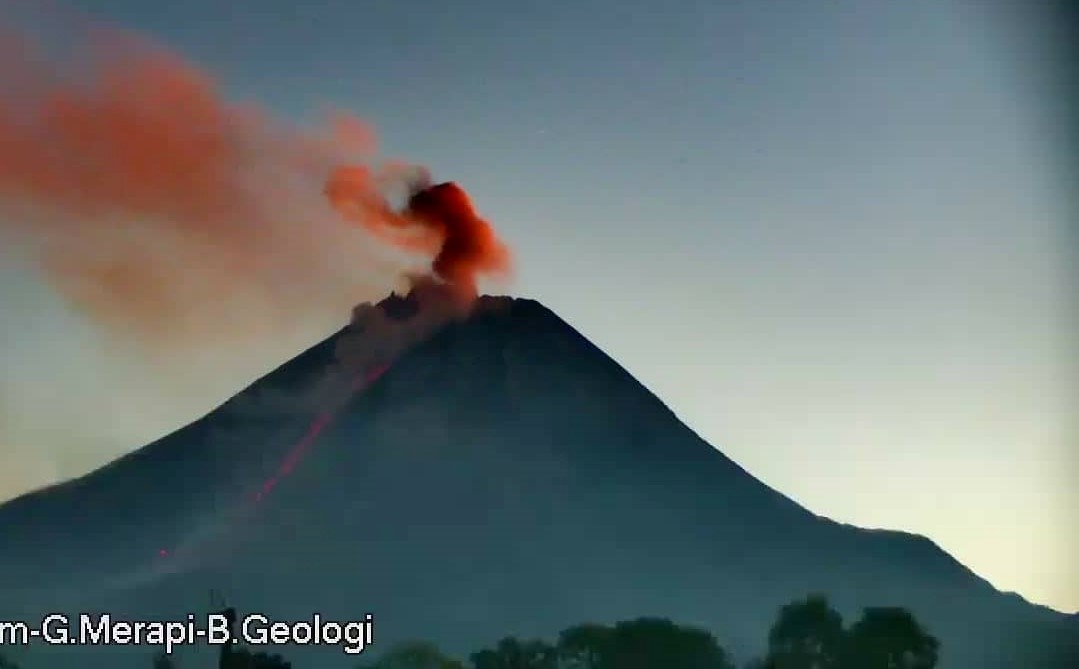
The weather around Mount Merapi is generally sunny in the morning and evening, while it is foggy in the afternoon. White, weak to thick, low pressure, 500m high fumes were observed from the Mount Merapi observation post in Kaliurang on September 26, 2021 at 5:20 a.m. WIB. Lava avalanches have been observed 67 times to the southwest with a maximum slide distance of 1,800 m.
An increase in the height of the southwest lava dome of about ± 1 m was observed. The volume of the southwest lava dome is 1,630,000 m3 and the central dome is 2,854,000 m3.
Seismicity
This week, the seismicity of Mount Merapi showed
244 low frequency earthquakes (LF),
1,268 multi-phase earthquakes (MP)
1,200 avalanche earthquakes (RF),
338 emission earthquakes (DG),
6 tectonic earthquakes (TT).
The intensity of this week’s seismicity is still quite high.
Deformation
The deformation of Mount Merapi which was monitored using EDM and GPS this week showed no significant changes.
Rain and lahars
This week, it rained at the Mount Merapi observation post with an intensity of 66 mm / hour for 50 minutes at Kaliurang post on September 25, 2021. There were no reports of lahars or additional flow in the mountains. rivers that originate from Mount Merapi.
Conclusion
Based on the results of visual and instrumental observations, it is concluded that:
The volcanic activity of Mount Merapi is still quite high in the form of effusive eruption activity. The status of the activity is defined in the “SIAGA” level.
Source : BPPTKG
Photo : Frekom
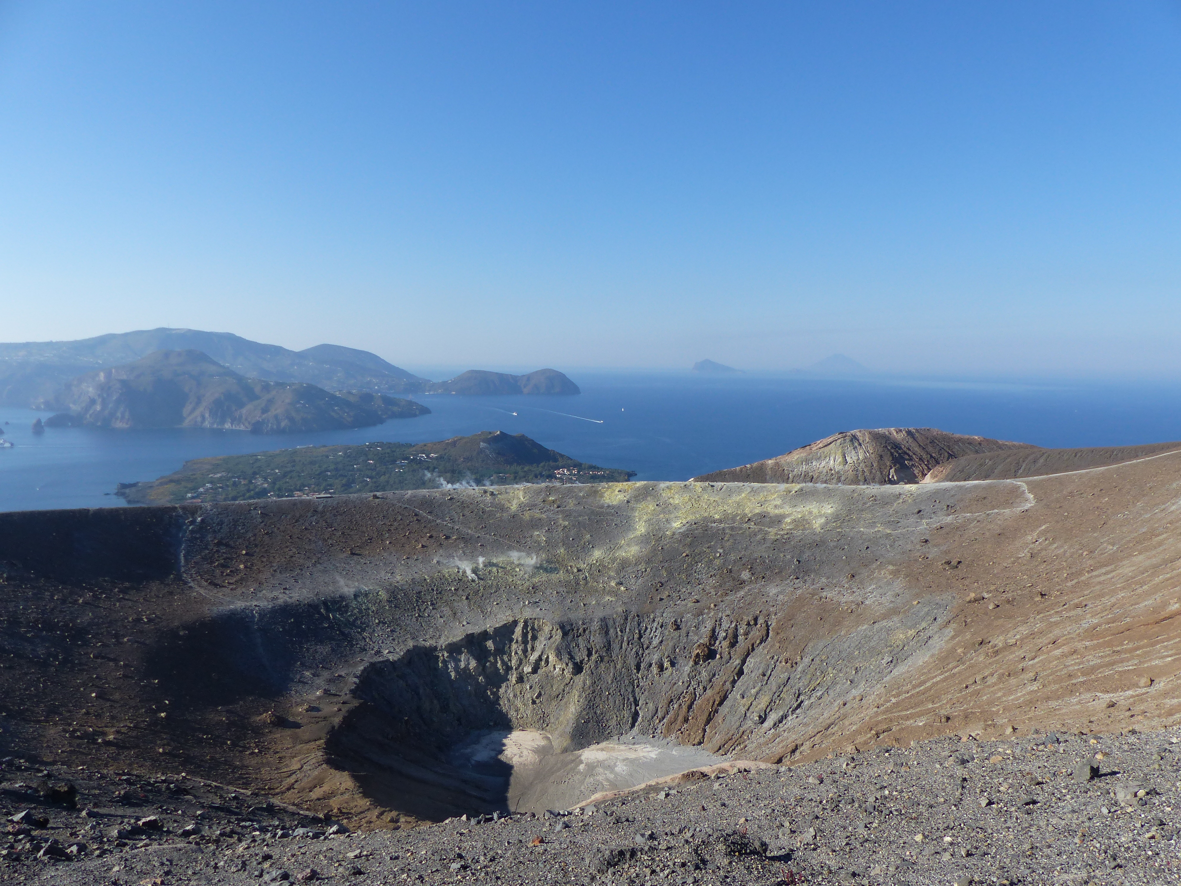
Italy , Vulcano :
During the summer, and in particular since September, the INGV monitoring systems have highlighted the variation of certain geophysical and geochemical signals recorded at Vulcano (Aeolian Islands), in particular those linked to the activity of the hydrothermal system. which feeds the fumaroles of the Crater de la Fossa.
In particular, the temperature of the gases emitted by the fumaroles at the edge of the crater has increased and the composition of the gases shows an increase in CO2 e SO2 (carbon dioxide and sulfur dioxide). Local micro-seismicity linked to the dynamics of the fumarolic system has also increased in recent weeks.
All information relating to the surveillance and monitoring that the INGV carries out on the island of Vulcano is transmitted in good time by the Observatory and the Section of Palermo to the Department of Civil Protection and to all the competent authorities, according to agreed procedures, for appropriate assessments.
The INGV is strengthening the existing surveillance and surveillance networks in order to better monitor developments in this situation.
These days, Osservatorio Etnéo has installed new seismic stations to complement those existing on the island, while setting up a thermal camera that frames the fumarole area of the crater. In addition, for about two months, the Palermo section of the INGV has activated 4 new stations in the Vulcano Porto area to measure the CO2 flow rate from the soil and the CO2 concentration in the air.
Further surveys and measurement campaigns are planned for the coming weeks. In particular, the annual campaign of GPS measurements between the islands of Vulcano and Lipari will be carried out in mid-October, in particular in the area of the Fossa cone, which will allow a better assessment of the current dynamics.
Based on the changes described above, the Department of Civil Protection has ordered the alert level to be changed from green to yellow for the island of Vulcano.
Source : INGV.
Photo : G Vitton.
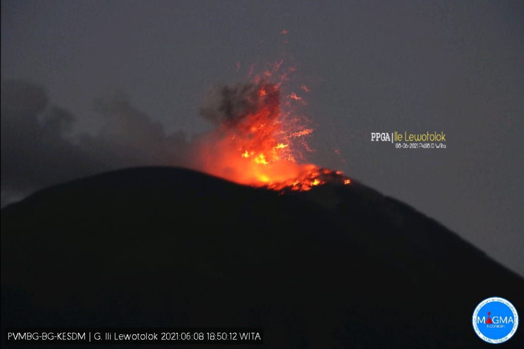
Indonesia : Ili Lewotolok .
VOLCANO OBSERVATORY NOTICE FOR AVIATION – VONA
Issued : October 01 , 2021
Volcano : Ili Lewotolok (264230)
Current Aviation Colour Code : ORANGE
Previous Aviation Colour Code : orange
Source : Ili Lewotolok Volcano Observatory
Notice Number : 2021LEW38
Volcano Location : S 08 deg 16 min 19 sec E 123 deg 30 min 18 sec
Area : East Nusa Tenggara, Indonesia
Summit Elevation : 4554 FT (1423 M)
Volcanic Activity Summary :
Eruption with volcanic ash cloud at 01h18UTC (09h18 local). Eruption and ash emission is continuing
Volcanic Cloud Height :
Best estimate of ash-cloud top is around 7114 FT (2223 M) above sea level, may be higher than what can be observed clearly. Source of height data: ground observer.
Other Volcanic Cloud Information :
Ash-cloud moving to west
Remarks :
Seismic activity is characterized volcanic tekctonic earthquake
Level of activity at level III (Siaga) since November 29, 2020 at 1:00 p.m. WITA.
The volcano is clearly visible until it is covered in fog. The smoke from the crater is white / gray with low intensity, medium to thick, about 50-800 meters above the summit. The weather is sunny to cloudy, the wind is weak to moderate in the west and northwest. The air temperature is approximately 25.1 to 35.9 ° C. The eruption was accompanied by a rumble and a low to moderate explosion noise, an ejection of incandescent material was observed up to 300m above the summit.
According to the seismographs of October 1, 2021, it was recorded:
60 eruption / explosion earthquakes
52 emission earthquakes
6 harmonic tremors
10 non-harmonic tremors
1 distant tectonic earthquake
Continuous tremor with an amplitude of 0.5 mm, mainly 0.5 mm.
Source : Magma Indonésie , PVMBG.
Photo : PVMBG.