June 29 , 2021.
Italy / Sicily , Etna :
Again and again …
Press release on ETNA activity, June 28, 2021 16:06 (14:06 UTC)
The National Institute of Geophysics and Volcanology, Osservatorio Etneo announces that the resumption of Strombolian activity at the level of the Southeast Crater has been observed since 14:01 UTC.
From 14:27 UTC, a strong increase in Strombolian activity is observed at the level of the Southeast Crater. Based on the forecast model, the eruptive cloud produced by the current activity disperses towards the South-South-East.
At 14.20 UTC the amplitude of the volcanic tremor is at high values with an increasing trend.
The last location of the tremor, at 13.45 UTC, is near the Southeast Crater at a depth of approximately 3.0 km. The number of infrasound events in the last 10 minutes at 14.22 UTC is average.
The last infrasound event is located near the Southeast Crater.
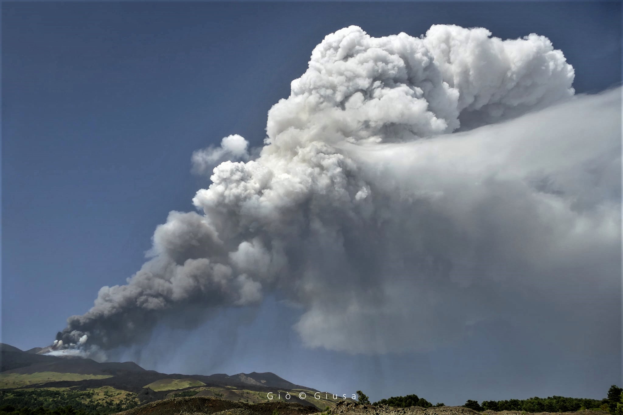
Press release on ETNA’s activity, June 28, 2021, 5:01 p.m. (3:01 p.m. UTC)
The National Institute of Geophysics and Volcanology, Osservatorio Etneo reports that a lava fountain is in place in the Southeast Crater. The explosive activity is accompanied by two lava flows, one in a southwest direction and a second in the southwest part of the Southeast Crater. Based on the forecast model, the eruptive cloud disperses in a south-easterly direction. At present, the height of the eruptive column has reached about 10 km above sea level.
At 14.40 UTC the amplitude of the volcanic tremor is on high values with an increasing trend. The last location of the tremor, at 13.45 UTC, is near the Southeast Crater at a depth of approximately 3.0 km. The number of infrasonic events in the last 10 minutes, at 14.26 UTC, is high.
Currently, weak variations in the signals of the inclinometric networks are observed; no variation is observable on the signals of the GNSS network.
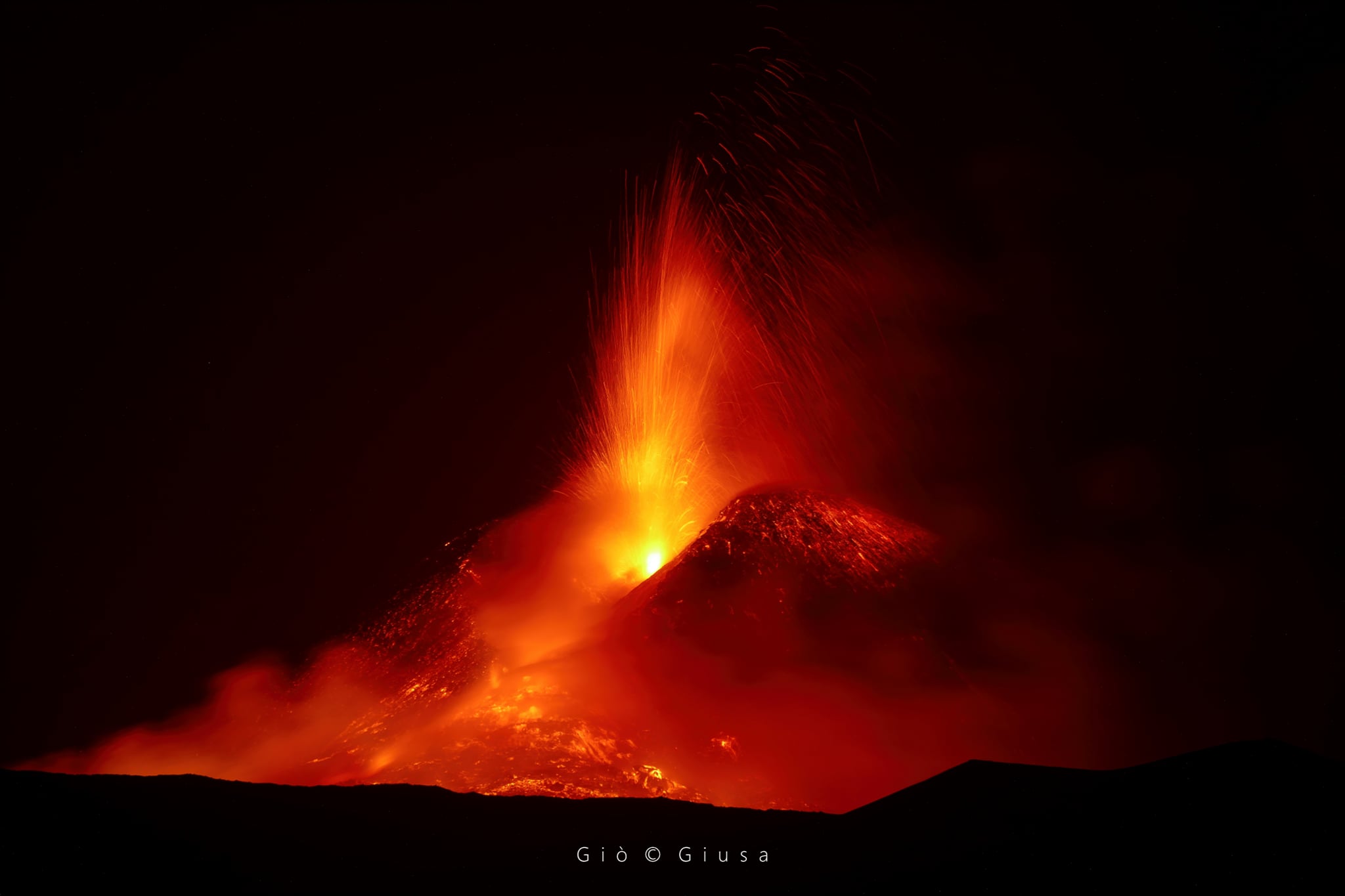
Press release on ETNA’s activity, June 28, 2021, 17:57 (15:57 UTC).
The National Institute of Geophysics and Volcanology, Osservatorio Etneo announces that from 3:30 p.m. UTC the lava fountain of the Southeast Crater has ceased, a weak Strombolian activity persists. The eruptive cloud produced exceeded the height of 10 km, derived from satellite data and according to the forecast model, its dispersion concerned the eastern sector of the volcano. As for the lava overflows, only that of the southwest remains supplied.
At 15.40 UTC the amplitude of the volcanic tremor is on high values with a decreasing trend. The last location of the tremor, at 14.45 UTC, is near the Southeast Crater at a depth of approximately 3.0 km. The number of infrasound events in the last 10 minutes, at 3:30 p.m. UTC, is very high.
The last infrasound event is located near the Southeast Crater.
During the lava fountain episode, slight variations were recorded at the stations of the inclinometric network; no significant variation is detectable at the stations of the GNSS network.
Further updates will be communicated shortly
Source : INGV.
Photos : Gio Giusa
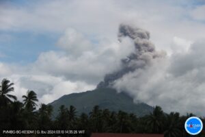
Costa Rica , Rincon de la Vieja :
Daily report of the state of the volcano; 28 June 2021, 10:58:00.
At 05:42:00 local time on June 28, 2021, an eruption was recorded on the Rincon de la Vieja volcano, with a column that rose 2,000 meters above the height of the crater and 3,916 meters above sea level (12,844.48 ft).
Duration of activity: 3 minutes.
Seismic activity is higher than yesterday.
At the time of this report, the winds are blowing from the northwest.
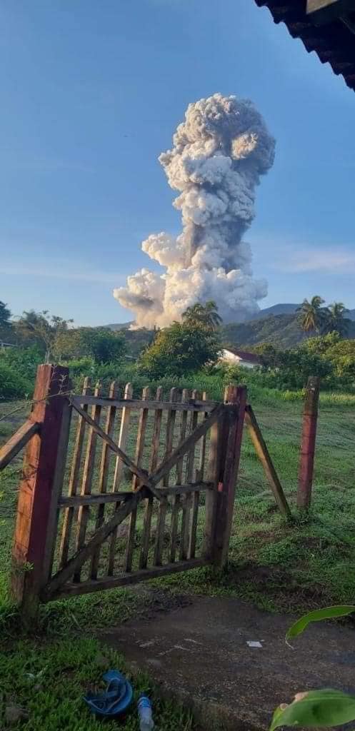
The plume was a mixture of ash and steam. The eruption generated lahars in the channels that descend from the crater to the north. Ash falls were reported in the North and North-West sector: Gavilan de Dos Ríos and Bromelias. A smell of sulfur was reported in the North and North-West sector.
The geodesic observations do not show any significant deformation of the volcanic building.
Source : Ovsicori.
Photo : Exclusivas Puebla.
Peru , Sabancaya :
Analysis period: June 21, 2021 to June 27, 2021, Arequipa, June 28, 2021.
Alert level: ORANGE
The Geophysical Institute of Peru (IGP) reports that the eruptive activity of the Sabancaya volcano remains at moderate levels, that is to say with the recording of an average of 1102 daily explosions, with columns of ash and gas up to an altitude of 3.0 km above the summit of the volcano and their consequent dispersion. Therefore, for the following days, no significant change is expected in eruptive activity.
The IGP recorded and analyzed the occurrence of 1,102 earthquakes of volcanic origin, associated with the circulation of magmatic fluids within the Sabancaya volcano. An average of 80 explosions was recorded daily. During this period, Volcano-Tectonic (VT) earthquakes associated with rock fractures were located mainly in the North-East and North-West of Sabancaya and presented magnitudes between M1.8 and M2.9.
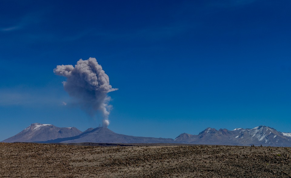
The monitoring of the deformation of the volcanic structure using GNSS techniques (processed with fast orbits) does not present any significant anomalies. However, in general, an inflation process was observed in the northern sector (around the Hualca Hualca volcano). Visual surveillance made it possible to identify columns of gas and ash up to 3.0 km altitude above the summit of the volcano, which were scattered towards the South-East, South, East and North-East sectors of the volcano. Sabancaya. Satellite recordings have identified the presence of 4 thermal anomalies (maximum value of 16 MW) associated with the presence of a lava body on the surface of the volcano’s crater.
RECOMMENDATIONS
• Keep the volcanic alert level in orange.
• Do not approach within a radius of 12 km from the crater.
Source : IGP.
Photo : pixabay
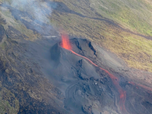
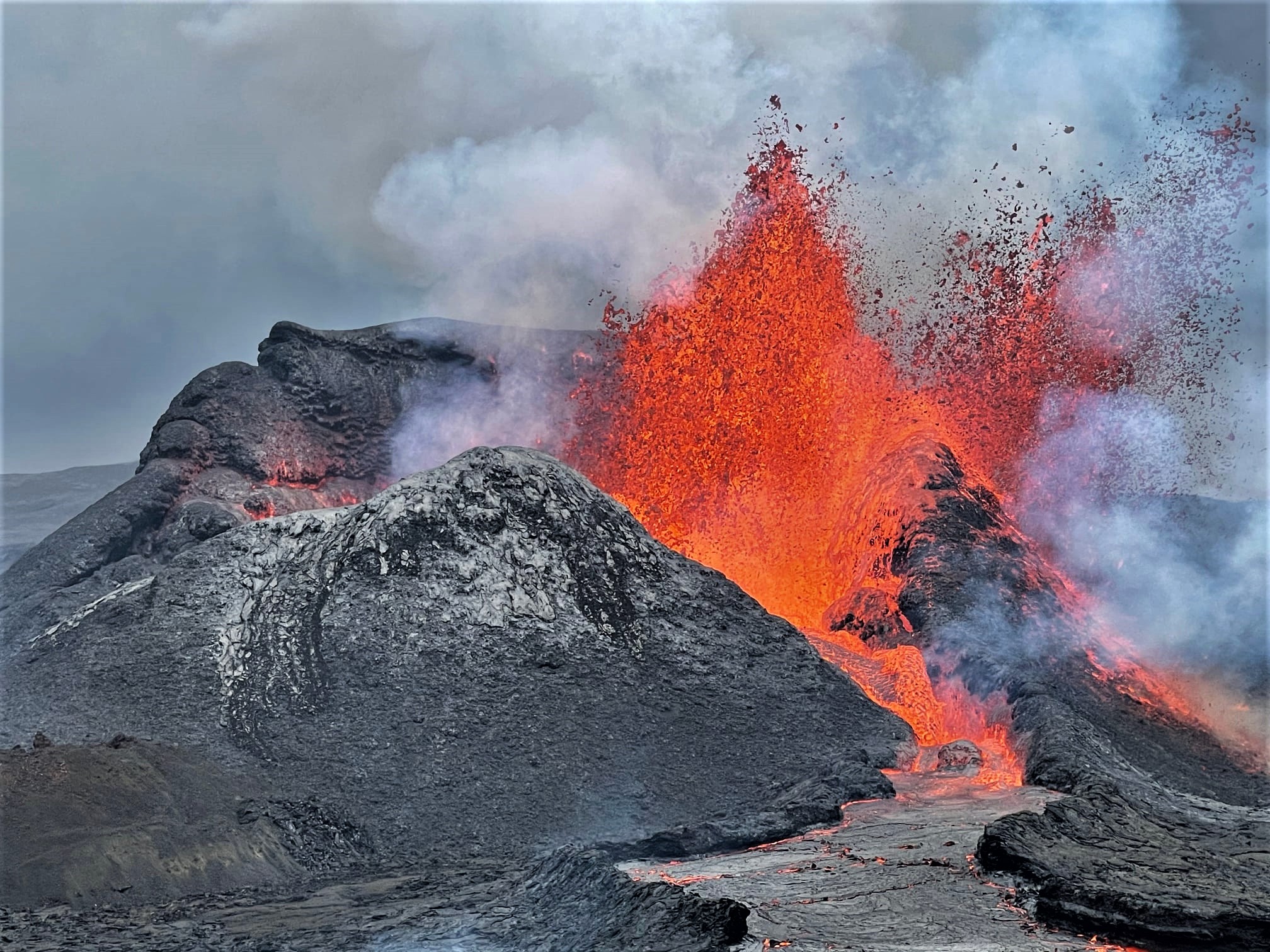
Iceland , Geldingadalur / Fagradalsfjall :
June 28, 2021
Lava flow measurements
Further measurements were taken on Saturday, June 26, when a drone flew with the Natural Resources Institute’s Hasselblad camera and now prepared new ground models of Fagradalsfjall with its images.
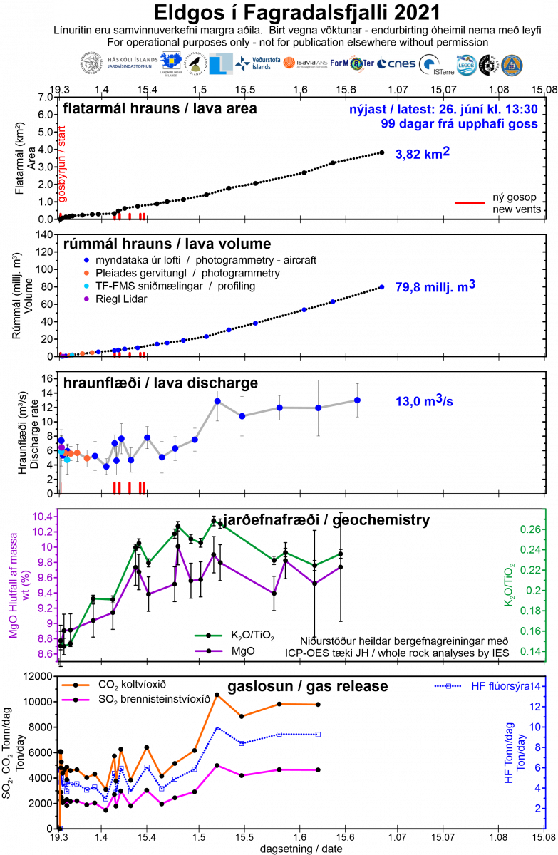
The average lava flow rate over the period June 11-26 (15 days) is 13 m3 / s, which is similar to that observed since the beginning of May, although a higher value was observed during the eruption. However, the difference between this figure and those who have arrived in recent weeks is not significant. The lava flow therefore remained almost stable for almost two months, on average twice as much as it was in the first six weeks.
The lava flow is now nearly 80 million cubic meters in size and has an area of 3.82 square kilometers. The increase in area per day is less than it was between the last measurements (June 2-11) (approximately 40,000 square meters per day instead of 60,000 m2 / day). In contrast, the thickening towards the east was 10-15 meters and 15 meters to the south. The strongest thickening, however, was in the Geldingadalur valley to the south and east of the crater, for about 20 meters.
It can be seen that the inflow vein and its properties have a great influence on the flow of magma. The open dyke was relatively narrow and long (reaching a depth of about 17 km) and its carrying capacity was limited. An increase over time indicates that the canal has widened somewhat over time, possibly due to erosion of its walls. It cannot be seen that the pressure in the source has decreased significantly and therefore the flow rate increased as the channel widened. There is currently no way to predict how long the eruption will last or whether the lava flows will continue to increase.
Source : jardvis.hi.is/
Photo : Guy de Saint Cyr.
Indonesia , Merapi :
VOLCANO OBSERVATORY NOTICE FOR AVIATION – VONA
Issued : June 29 , 2021
Volcano : Merapi (263250)
Current Aviation Colour Code : ORANGE
Previous Aviation Colour Code : orange
Source : Merapi Volcano Observatory
Notice Number : 2021MER04
Volcano Location : S 07 deg 32 min 31 sec E 110 deg 26 min 31 sec
Area : Special Region of Yogyakarta, Indonesia
Summit Elevation : 9498 FT (2968 M)
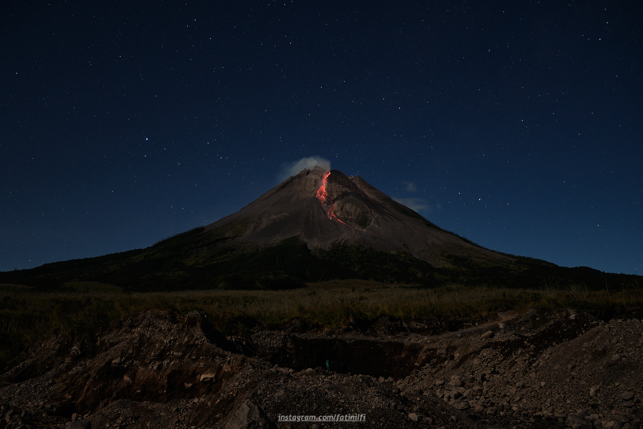
Volcanic Activity Summary :
Eruption with volcanic ash cloud at 04h32 UTC (11h32 local). The eruption has stopped.
Volcanic Cloud Height :
Best estimate of ash-cloud top is around 11098 FT (3468 M) above sea level, may be higher than what can be observed clearly. Source of height data: ground observer.
Other Volcanic Cloud Information :
Ash cloud generated by PDC moving to the west.
Remarks :
Pyroclastic density current was recorded in seismogram with max amplitude 60 mm and duration 152 s.
Source : Magma Indonésie .
Photo : merapi_uncover.
Chile , Nevados de Chillan :
Special Report on Volcanic Activity (REAV), Ñuble region, Nevados de Chillán volcanic complex, June 28, 2021, 08:45 a.m. local time (Continental Chile).
The National Service of Geology and Mines of Chile (Sernageomin) publishes the following PRELIMINARY information, obtained thanks to the monitoring equipment of the National Volcanic Monitoring Network (RNVV), processed and analyzed in the Volcanological Observatory of the Southern Andes ( Ovdas):
On Monday, June 28, at 08:19 local time (12:19 UTC), the monitoring stations installed near the volcanic complex of Nevados de Chillán recorded an earthquake associated with fluid dynamics (long period type) in the volcanic system.

The characteristics of the earthquake after its analysis are as follows:
TIME OF ORIGIN: 08:19 local time (12:19 UTC)
LATITUDE: 36.873 ° S
LONGITUDE: 71.378 ° W
DEPTH: 0.4 km
REDUCED DISPLACEMENT: 617 (cm2)
ACOUSTIC SIGNAL: 2.9 Pascals (Pa) reduced to 1 km.
The characteristics of the surface activity are as follows:
Maximum column height: 780 m above the emission point.
Direction of dispersion: North.
The volcanic technical alert remains at the Yellow level.
Source : Sernageomin.
Photo : RTV Vision noticias .