June 5 , 2021.
Italy / Sicily : Etna ,
Press release on ETNA’s activity, 04 June 2021, 12:13 (10:13 UTC).
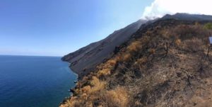
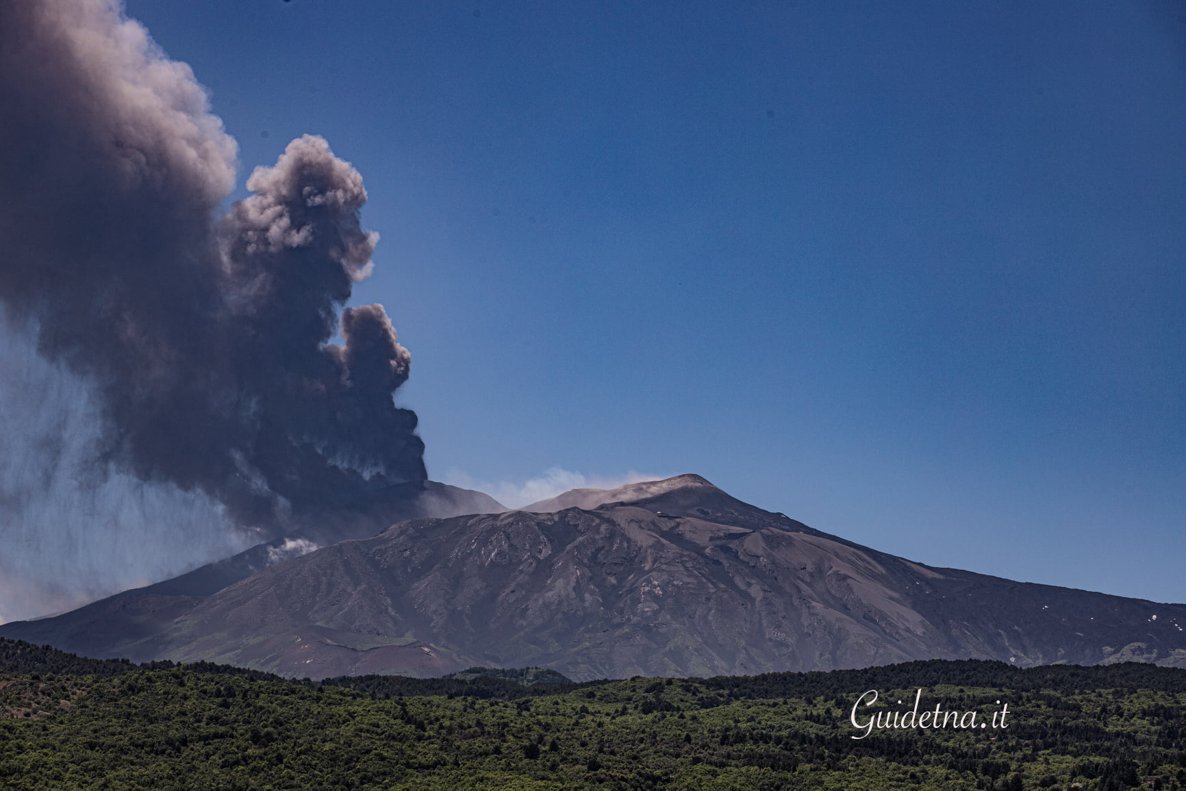
The National Institute of Geophysics and Volcanology, Osservatorio Etneo, announces that the improvement in meteorological conditions has made it possible to observe from surveillance cameras that the weak intracrater Strombolian activity continues at the level of the Southeast Crater and that the lava overflow it generated in the last Lava Fountain event (Update Advisory # 338) is cooling. In addition, intra-crater explosive activity at the Bocca Nuova crater reported in update No. 335 and, at the same time, occasional ash emissions are observed from the Northeast Crater which rapidly disperse into the summit area.
From the seismic point of view, the mean amplitude values of the volcanic tremor are at a medium-high level, still showing small fluctuations. The centroid of the volcanic tremor sources remains located in the area of the Southeast Crater at an altitude of about 2900 m s.l.m. The infrasound activity remains at low levels and the sources are located near the crater of Bocca Nuova.
Soil deformation monitoring networks do not show substantial variations.
Press release on ETNA’s activity, 04 June 2021, 18:55 (16:55 UTC).
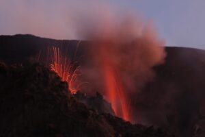
From around 4:20 p.m. UTC, the passage of Strombolian activity from the Southeast Crater to the lava fountain stage can be observed from surveillance cameras. Based on the forecast model, the eruptive cloud disperses in a south-easterly direction.
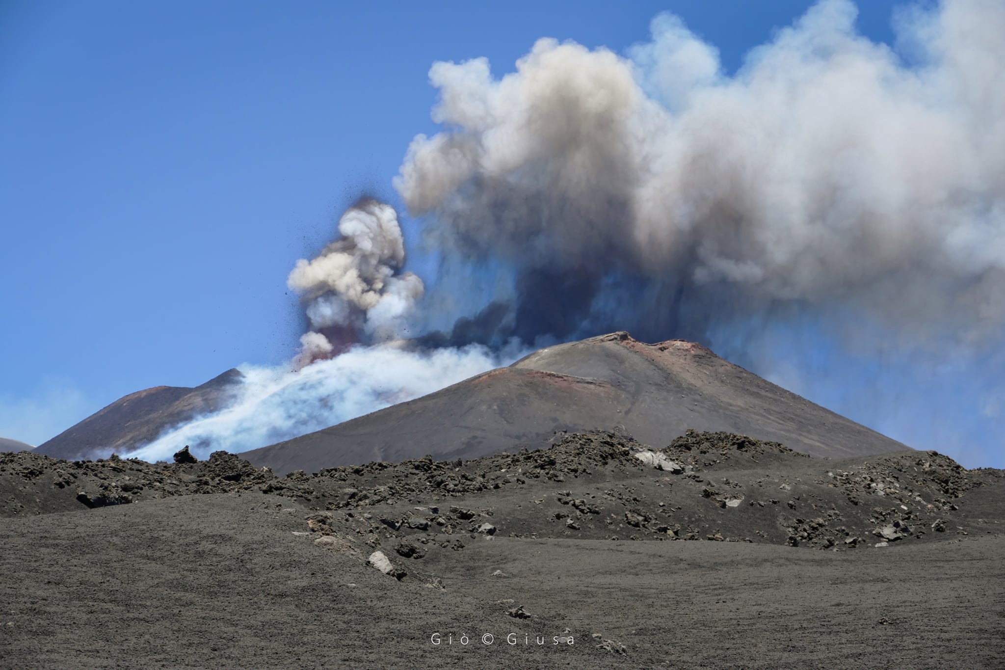
The National Institute of Geophysics and Volcanology, Osservatorio Etneo, announces that in addition to update No. 345, the eruptive cloud formed by the lava fountain which, according to the forecast model, disperses to the South- Is, reaches a height of about 6500 m above sea level.
From around 3:30 p.m. UTC, a further increase in the mean amplitude of the volcanic tremor is observed, which is currently at very high levels. The centroid of the volcanic tremor sources is located in the area of the Southeast Crater at an altitude of about 3000 m s.l.m .. The infrasound events show a medium to high amplitude and are located in the area of the Southeast Crater.
The summit stations of the inclinometer network show a modest variation linked to the activity of the lava fountains. No significant change in GNSS data.
Press release on ETNA’s activity, 04 June 2021, 20:10 (18:10 UTC).
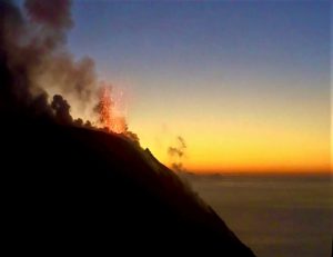
The National Institute of Geophysics and Volcanology, Osservatorio Etneo, reports that as of 5.30 p.m. UTC, the lava fountain in the Southeast Crater gradually ran out. In accordance with the forecast model, the dispersion concerned the south-eastern sector of the volcano. INGV staff in the field report product fallout in Aci Castello, Tremestieri and Catania (Ognina). The eruptive cloud reached a height of about 6500 m above sea level. In addition, the lava fountain produced an overflow of lava along the southern slope of the Southeast Crater, which spread in a southwest direction.
From around 17:00 UTC there is a rapid decrease in the average amplitude values of the volcanic tremor which is placed at a high level with a tendency to decrease. The centroid of the volcanic tremor sources remains located in the area of the Southeast Crater at an altitude of about 3000 m s.l.m. The infrasound activity, too, which continues to be located in the Southeast Crater area, shows a marked decrease in the number of events and their amplitude.
Modest variations are visible in the signals from the summit tilt stations. Nothing relevant on the other hand on the signals of the GNSS network.
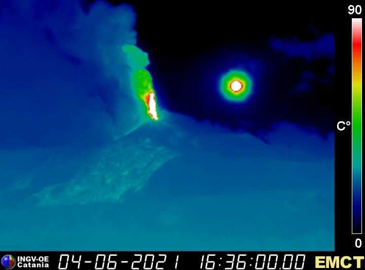
Thermal camera in Monte Cagliato, on the Ethnic East side. The round object that we see on the right is the sun.
Further updates will be communicated shortly.
According to the images of the surveillance cameras, we observe that the explosive activity at the level of the Southeast Crater has ceased, however the lava overflow which extends in a southwest direction is still fed and its front is located at an altitude of about 2800 m asl
The mean amplitude of the volcanic tremor around 19:00 UTC reached a low level with a continuing downward trend.
Source : INGV.
Photos : Guide Alpine Vulcanologiche Etna ( 26 /05) , Gio Giusa , INGV / Marco Neri.
Indonesia , Merapi :
Mont Merapi activity report from May 28 to June 3, 2021
– The weather around Mount Merapi is generally sunny in the morning and evening, while it is foggy in the afternoon and evening.
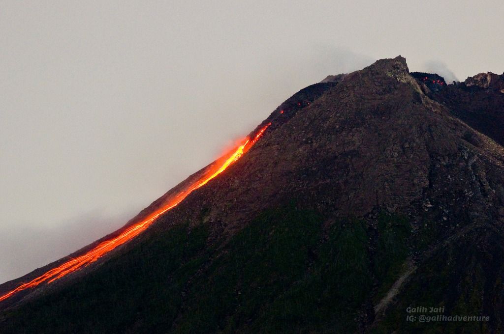
– Hot cloud avalanches occurred 7 times with a maximum slide distance of 2000 m to the southwest and were recorded on a seismogram with a maximum amplitude of 60 mm and a duration of 322 seconds.
– Lava avalanches were observed 44 times towards the South-West with a maximum slide distance of 2000 meters and 1 time towards the South-East with a slide distance of 600 m.
– The volume of the lava dome in the southwest sector is 1,325,000 m3 with a growth rate of 11,600 m3 / day.
– The morphological analysis of the summit area based on photos of the South-East sector from June 3 to May 28, 2021, shows a difference in height of the central dome of 1 m.
– This week’s seismicity intensity is higher than last week.
– The deformation of Mount Merapi, which was monitored by EDM this week, showed a distance shortening rate of 0.9 cm / day.
– There is no report of lahars or additional flow in the rivers that originate at Mount Merapi.
Conclusion:
– The volcanic activity of Mount Merapi is still quite high in the form of effusive eruption activity. The status of the activity is defined in the “SIAGA” level.
– The current potential danger consists of lava avalanches and hot clouds in the South-South-West sector covering the Kuning, Boyong, Bedog, Krasak, Bebeng and Putih rivers for a maximum of 5 km and in the sector South-East, the Gendol river for 3 km. During this time, the ejection of volcanic material in the event of an explosive eruption can reach a radius of 3 km from the summit.
Source : BPPTKG.
Photo : Yohannes Tyas Galih Jati / Volcanodiscovery .
Saint Vincent , Soufrière Saint Vincent :
La Soufriere Volcano – SCIENTIFIC UPDATE , June 03, 2021 6:00PM
– Seismic activity at La Soufrière, St Vincent has remained low since the tremor associated with the explosion and ash venting on 22 April.
– In the last 24 hours, only a few long-period earthquakes have been recorded.
– Persistent steaming is observable from the observatory once the cloud cover is high enough.

– Thermal anomalies continue to be detected but do not indicate an explosive event is imminent but that there is a source of heat, most likely from a small body of magma left over, close to the floor of the Summit Crater.
– Measurement of the sulphur dioxide (SO2) flux was carried out off the west coast on June 1st and 3rd and yielded an average SO2 flux of 543 and 456 tons per day, respectively. SO2 can be an indicator that fresh magma from a deeper source is being degassed.
– The volcano continues to be in a state of unrest. Escalation in activity can still take place with little or no warning.
-The volcano is at alert level ORANGE.
Source : UWI.
Photo : Desert Fox.
Democratic Republic of Congo , Nyiragongo :
The GPS network of the Goma Volcanological Observatory did not detect any movement of movement of the magma below the city of Goma and Lake Kivu.
The latest satellite data recorded indicate that the ground continued to deform between May 27 and June 2.
However, the readings of the openings of the cracks measured in the city of Goma do not indicate any deformation since June 1.
New landslides are still possible in the crater and could cause ash fallout in neighboring regions.
The favorable development of the situation continues even if we cannot totally exclude a revival in activity. This justifies the continuation of intensive surveillance and the daily reassessments of the situation carried out by the OVG.
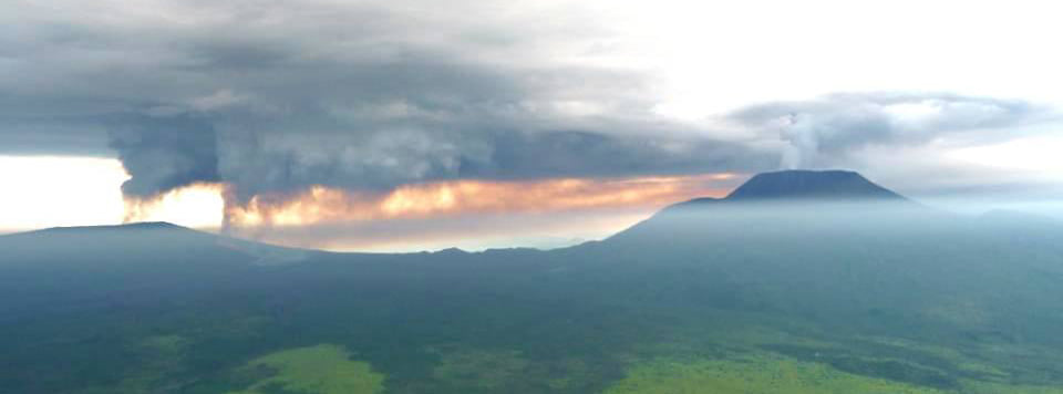
Each eruption produces huge volumes of ash and volcanic plumes that severely affect surrounding areas. Ash can contaminate drinking water sources and food crops.
June 04, 2021 : The seismic data, recorded today, indicate little change from the situation on June 3. The GPS network has not detected any movement at the stations today. The physical impossibility of installing seismic or GPS stations in the lake does not allow precise detection of a possible rise of magma under the lake. New landslides are still possible in the crater and could cause ash fallout in neighboring regions. The favorable development of the situation continues, although we cannot totally exclude an upturn in activity. This justifies the continuation of the intensive surveillance and the daily reassessment of the situation carried out by the OVG
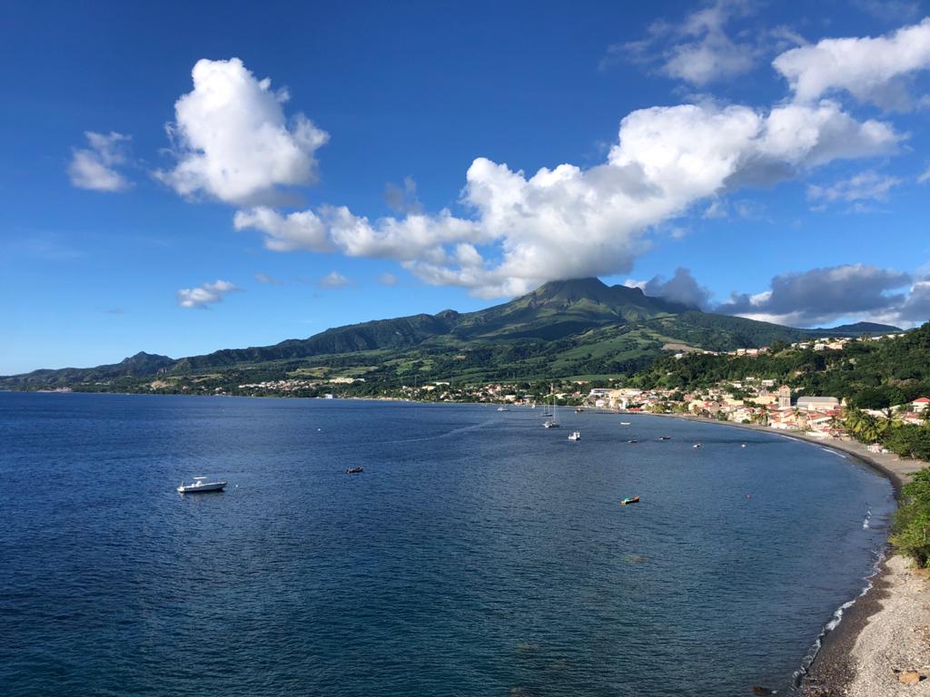
La Martinique , Montagne Pelée :
Weekly report on the activity of Mount Pelée for the period from May 28, 2021 to June 04, 2021.
The seismicity of volcanic origin has remained relatively stable over the past week. Between May 28, 2021 at 4 p.m. (UTC) and June 04, 2021 at 4 p.m. (UTC), OVSM recorded at least 11 volcano-tectonic earthquakes of magnitude less than 0.2. These earthquakes were located inside the volcanic edifice between sea level and 0.5 km above sea level. None of these earthquakes were felt by the population. This volcano-tectonic-type superficial seismicity is associated with the formation of micro-fractures in the volcanic edifice.
During phases of volcanic reactivation, periods of higher seismic activity often alternate with phases of weaker seismicity. Seismicity above the level
base is always saved. No other changes were noted in the activity of Mount Pelée.
A main area of heavily degraded vegetation is still observed on the southwest flank of Mount Pelée, between the upper Claire River and the Chaude River.
These observations reflect the variable dynamics of the processes of magmatic and hydrothermal origin at Mount Pelée in line with its renewed activity since April 2019.
The alert level remains YELLOW: vigilance.
Source: Direction of OVSM IPGP.
Read the article : https://www.facebook.com/photo?fbid=430259795071533&set=a.372931027471077
Photo : rci.fm