May 20 , 2021.
Italy , Stromboli :
PRESS RELEASE ON THE ACTIVITY OF STROMBOLI, May 19, 2021, 15:08 (13:08 UTC)
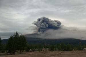
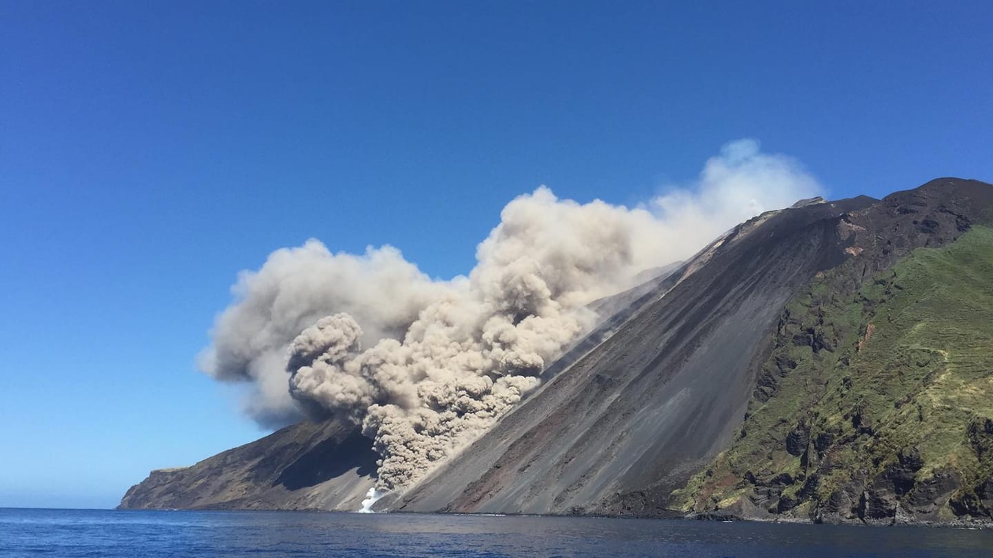
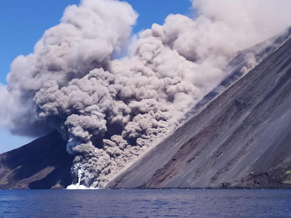
The National Institute of Geophysics and Volcanology, Osservatorio Etneo, announces that at 12:51 UTC, CCTV footage showed the formation of a large ash cloud that affected the Sciara del Fuoco all the way to the coast.
PRESS RELEASE ON THE ACTIVITY OF STROMBOLI, May 19, 2021, 15:38 (13:38 UTC)
The National Institute of Geophysics and Volcanology, Osservatorio Etneo, announces that from 12:47 UTC an increase in explosive activity was observed from the area of the North crater which at 12:51 produced a pyroclastic flow that there reached the coastline extending into the sea for more than 1 km and producing an ash cloud which reached an estimated height of about 1.5 to 2 km above sea level. Lesser intensity pyroclastics occurred from 1:02 PM UT, producing modest clouds of ash and warm coarse material reaching the shore. The phenomenon is still ongoing.
From 12:51 GMT, a transient of around 0.1 microradians is visible on the inclinometric signal from Timpone del Fuoco.
PRESS RELEASE ON THE ACTIVITY OF STROMBOLI, May 19, 2021, 16:41 (14:41 UTC)
The National Institute of Geophysics and Volcanology, Osservatorio Etneo, announces that a lava flow is underway along the Sciara del Fuoco whose front reaches the coast.
The phenomenon described in the previous press release was repeated with several episodes, of less intensity, until 13:35 UTC. More intense explosive activity was observed during these events. An overflight is underway with the fire brigade helicopter in order to acquire more information on the phenomenon in progress.
In conjunction with the observed volcanic phenomenology, an increase in the seismic trace was recorded starting at 12:47 UTC, which may be associated with the dynamics of pyroclastic flow along the Sciara del Fuoco. In particular, a series of events was recorded (at 12:51, 13:04, 13:09, 13:13 UTC, etc.) clearly visible at the Ginostra ISTR seismic station and at the STR4 station.
The inclinometric signal from Timpone del Fuoco shows some modest transients (around + -0.2 microradians) between 12: 51-12: 55 UTC, between 13: 10-13: 15 UTC and between 13: 51-13: 53 UTC . The GNSS network is currently not available for data transmission problems.
PRESS RELEASE ON STROMBOLI ACTIVITY, 19 May 2021, 18:50 (16:50 UTC)
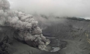
The National Institute of Geophysics and Volcanology, Osservatorio Etneo, announces that following the overflight carried out by INGV staff with the firefighting helicopter, it was observed that the pyroclastic flow, described in the press release No. 5, came from the collapse of the flank of the northern crater (CN). The latter produced a lava overflow that spills along the Sciara del Fuoco until it reaches the coast.
It is also announced that the explosive activity will continue. It should be noted that Stromboli seismic signals (with the exception of ISTR and STR4 stations) have not been available since 2.36pm local time due to data transmission issues reported in the 13:33 UTC press release. The magnitude of the tremor, observable at the 2 stations, is currently at values comparable to those that preceded today’s release No. 4. Regarding the magnitude of the explosion earthquakes, at the ISTR station there is a slight upward trend compared to what was observed before the volcanic phenomenon.
After the previous variations already reported, the Timpone del Fuoco inclinometric signal shows other modest transients of lower intensity. The GNSS network is not yet available.
Other updates will be announced soon.
Source : INGV.
Read the article : ComunicatoSTROMBOLI20210519143351.pdf (ingv.it)
Photos : INGV , Ashàra , Michele Giardulli .
La Réunion Island , Piton de la Fournaise :
Press release of May 19, 2021 – 2:00 p.m.
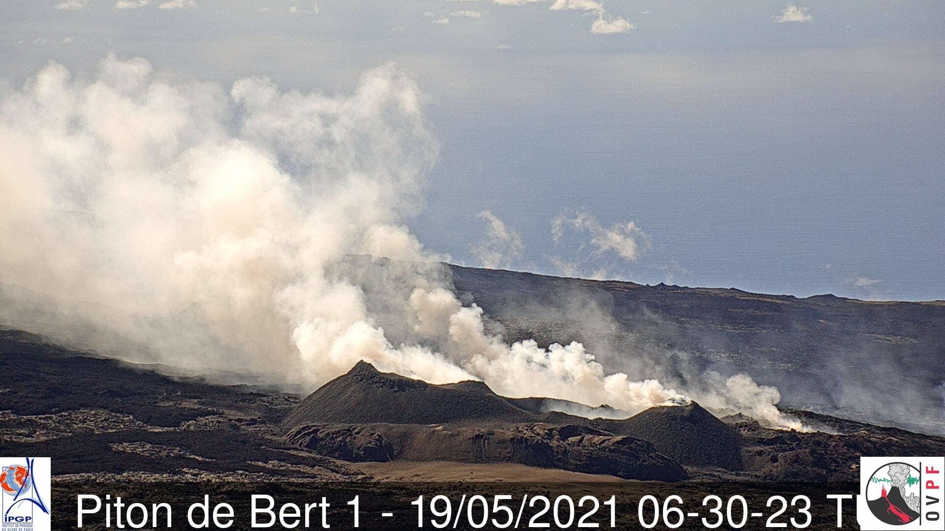
The eruption that started on 04/09/2021 at 7 p.m. (appearance of the tremor) continues. The amplitude of the volcanic tremor (indicator of a surface lava emission) continues its slow decrease that began on May 2.
The images from the OVPF and OVPF / IRT cameras for the last 24 hours that:
– The activity at the two cones is down slightly;
– A strong degassing persists at the level of the two cones;
– the flow of lava at the exit of the eruptive vents, occurs mainly in tunnels up to the upper limit of the large slopes, where resurgences of lava are sometimes visible on the surface;
– the flow front progresses only very slowly in the Grandes Pentes.
Over the past 24 hours, 2 superficial volcano-tectonic earthquakes (between sea level and the surface) have been recorded, located directly above the summit craters.
– The CO2 fluxes in the soil are always increasing in the far field (Plains region).
– The slight inflation trend of the building observed in recent days is confirmed.
– No estimate of lava flow could be established by the HOTVOLC platform (OPGC – Clermont Auvergne University), because the lava flow is now almost entirely in a tunnel linked to the thermal radiation of the flow.
– Practical conditions in the eruptive site area improved during the morning (Figure 3) and deteriorated again in the early afternoon.
Alert level: Alert 2-2
Source et photo : OVPF.
Read the article : https://www.ipgp.fr/sites/default/files/ovpf_20210519_14h00_communique_eruption.pdf
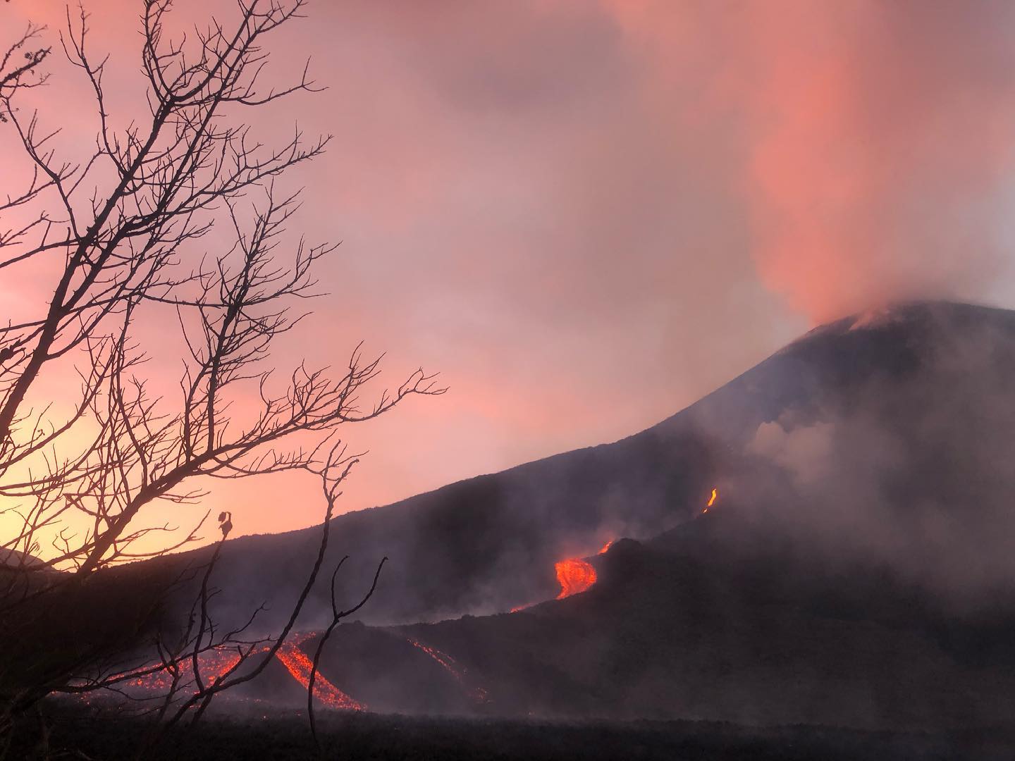
Iceland , Geldingadalur :
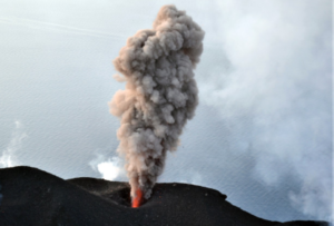
IMO reported that the fissure eruption in the W part of the Krýsuvík-Trölladyngja volcanic system, close to Fagradalsfjall on the Reykjanes Peninsula, continued during 11-18 May. The lava effusion rate was 10.8 meters per second, lower than the 12.9 meters per second rate recorded the week before. Pulsating lava fountains from crater 5, about 7-8 episodes per hour, sent material higher than 300 m.
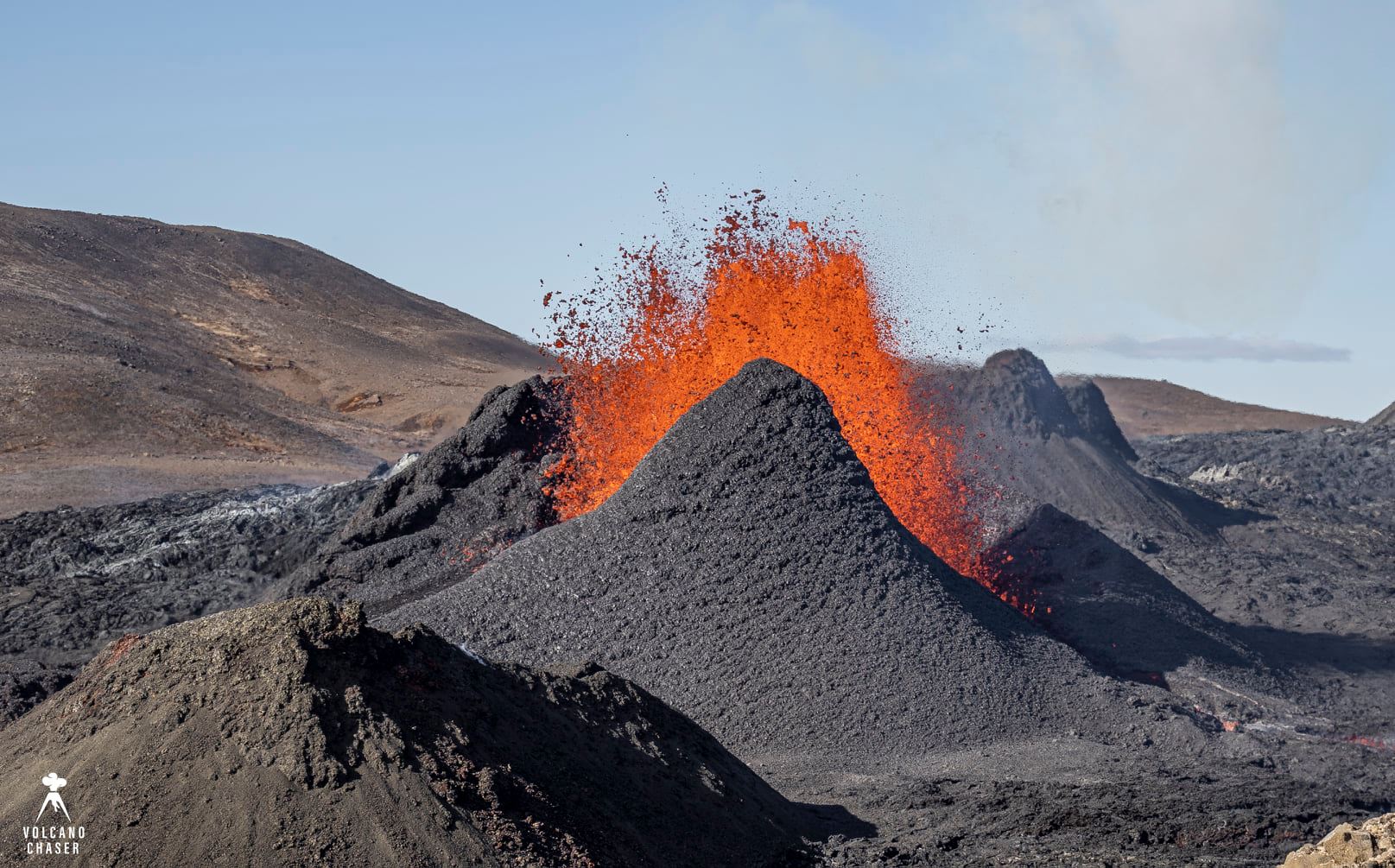
Very high fountains were visible in Reykjavik. Lava continued to flow into the Meradalir Valley; on 17 May video showed sections of the cone’s rim collapsing into the crater. By 18 May the area of the flow field had grown to 2.06 square kilometers, the total volume erupted was 38 million cubic meters. Authorities directed the construction of earthen barriers to prevent lava flowing into the Nátthaga valley and possibly overtaking Highway 427 (Suðurstrandarvegur) to the S, protecting the road and buried fiberoptic cables. The Aviation Color Code remained at Orange due to the lack of ash and tephra emissions. Authorities warned of increased gas emissions hazards.
Source : GVP
Photo : Volcano chaser / Marc Szeglat
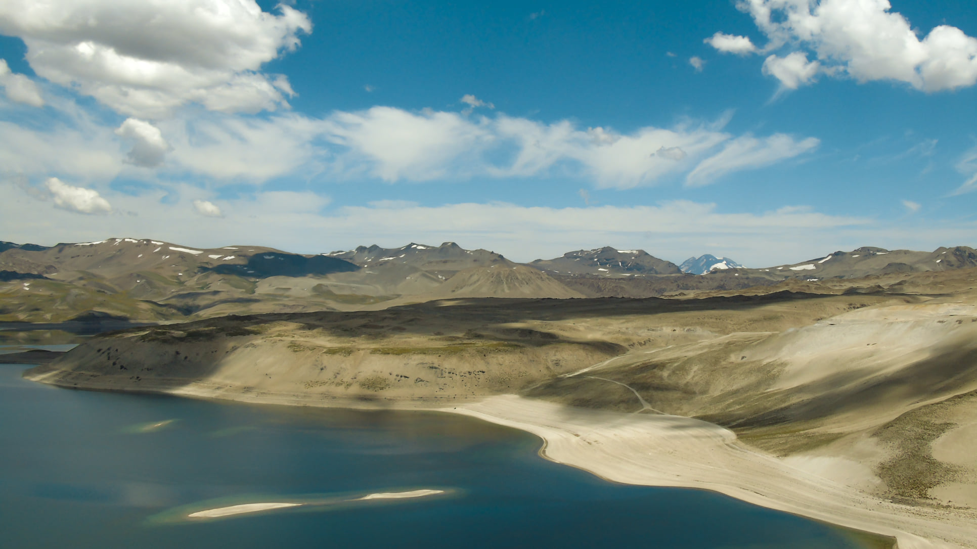
Chile , Laguna del Maule :
Special Report on Volcanic Activity (REAV), del Maule region, Laguna del Maule volcanic complex, May 15, 2021, 10:40 p.m. local time (Continental Chile).
The National Service of Geology and Mines of Chile (Sernageomin) publishes the following PRELIMINARY information, obtained thanks to the monitoring equipment of the National Volcanic Monitoring Network (RNVV), processed and analyzed at the Volcanological Observatory of the Southern Andes ( Ovdas):
On May 15 at 19:48 local time (23:48 UTC), monitoring stations installed near the Laguna del Maule volcanic complex recorded a seismic swarm of 156 volcano-tectonic (VT) events, associated with rock fracturing, located 7 km south-southwest of the center of the lagoon.
The characteristics of the most important earthquake after its analysis are as follows:
TIME OF ORIGIN: 19:55 local time (23:55 UTC)
LATITUDE: 36.105 ° S
LONGITUDE: 70.565 ° W
DEPTH: 6.3 km
LOCAL MAGNITUDE: 1.8 ML
OBSERVATIONS:
At the time of this report, the seismic activity exhibited sporadic, lower energy VT-type earthquakes.
The volcanic technical alert remains at the Yellow level.
Source : Sernageomin.
Photo : Franco Vera.
Guatemala , Pacaya :
SPECIAL VOLCANOLOGICAL BULLETIN, May 19, 2021, 8:45 a.m. local time.
Since May 15, the Pacaya volcano has presented a change in its eruptive pattern, the lava flow active in recent weeks has stopped, the main activity is currently located in the Mackenney crater. This activity consists of periods of constant emission of columns of gas and ash at a height of up to 3,500 meters above sea level (11,483 feet) that move in the direction of the wind. There are also explosions of weak to moderate characteristics which expel ballistic projections to a maximum height of 100 meters above the crater. Ash falls have been reported in the communities of San Francisco de Sales, Concepción El Cedro, Aldea El Patrocinio and San Miguel Petapa.
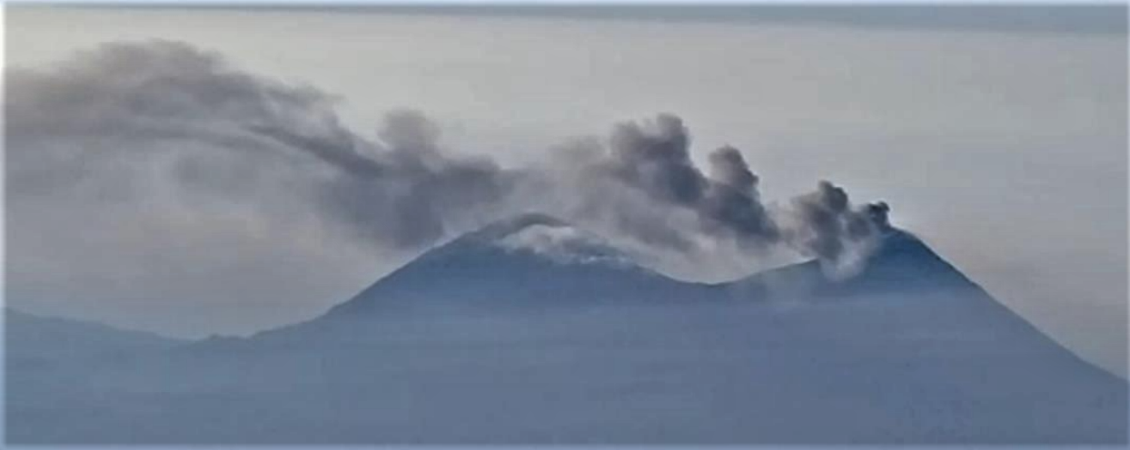
Column of ash moving north. Photograph taken by the Agua OVAGU volcano observatory, INSIVUMEH.
This activity is expected to continue for the following days or weeks, so ashfall is expected in the communities around the volcano depending on the wind direction. It is not excluded that periods of high explosiveness will be generated in the coming hours or days and / or the emergence of lava flows on the various sides of the Pacaya volcano.
Source : INSIVUMEH
Photos : Salamandra house , Insivumeh.
Colombia , Nevado de Santa Isabel :
Manizales, May 19, 2021 (09:50 local time)
Subject: Bulletin of extraordinary activity of the Nevado de Santa Isabel volcano. The green activity level is maintained or (IV): Active volcano and stable behavior.
Regarding the monitoring of the activity of the Nevado del Santa Isabel volcano, the COLOMBIAN GEOLOGICAL SERVICE reports that:
As of yesterday, May 18, 2021, at 7:43 p.m. (local time), there has been an increase in seismic activity associated with the fracturing of the rock around the volcanic building of the Nevado de Santa Isabel volcano.
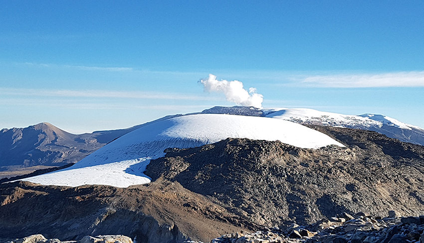
The earthquakes are located on the west-northwest flank of the volcano, at depths between 3.0 and 7.0 km. Over the past few hours, the number of events and their seismic energy have increased. Until the time of publication of this report, there have been three earthquakes with a magnitude greater than 2.0 ML (local magnitude). The maximum magnitude recorded to date is 2.6 ML (local magnitude), corresponding to the earthquake that occurred at 07:00 (local time), located 2.5 km north-northwest of the volcanic structure, at a depth of 3.5 km. It should be noted that this increase is the one with the greatest number of events occurring in the region since December 2017.
It is recommended that the community continue to be attentive to any changes that occur in the activity of the volcano.
Source : Ingeominas .
Photo : masaya experience.