March 25 , 2021 .
Italy / Sicily , Etna :
Communication on ETNA’s activity, March 24, 2021, 13:47 (12:47 UTC).
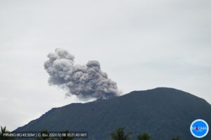
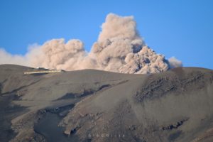
The National Institute of Geophysics and Volcanology, Osservatorio Etneo, reports that the explosive activity of the Southeast Crater, which formed a volcanic cloud about 4.5 km high, has ceased. From the images of surveillance cameras and INGV-OE personnel present on site, it can be seen that the flows are still powered. However, due to the presence of cloud cover, observations in the summit area are discontinuous.
From the seismic point of view, the amplitude of the volcanic tremor has returned to average values.
At the same time, from 08:30 (UTC), infrasound activity shows a decrease in both the rate of occurrence and the energy of events.
The soil deformation networks show the return to stability of the signals.
Further updates will be communicated shortly.

At 03:37 this morning, March 24, 2021, a phenomenon that was once thought not to occur on Etna repeated itself: a pyroclastic flow. Preceded by a sudden intensification of the activity of the Southeast Crater, the hot material deposited in the previous hours on the steep side of the cone began to collapse, generating a pyroclastic flow directed towards the Valle del Bove. The stream reached a length of about 1 km and was incandescent at the base.
The photos show the dense black cloud that rose during the first few minutes of the pyroclastic flow, lit by the lava fountains on the other side. View of Tremesteri Etneo.
Source : INGV , Boris Behncke .
La Réunion , Piton de la Fournaise :
Activity bulletin for Thursday 25 March 2021 at 9:15 (local time).
Following the resumption of seismicity on March 13 under the Piton de la Fournaise, it continued and intensified. Thus between March 13 and 24, 250 summit volcano-tectonic earthquakes, with a magnitude between <1 and 2.6, were recorded and located under the Dolomieu crater between 0 and 0.9 km above sea level. (ie between 1.6 and 2.5 km deep; Figure 2). Yesterday, March 24, 81 earthquakes were recorded under the summit area, including an earthquake of magnitude 2.6. This seismicity leads to destabilization of the edges of the Dolomieu crater and the number of collapses, 31 yesterday, is also increasing.

Figure 1: Histogram representing the number of superficial volcano-tectonic earthquakes recorded between January 1 and March 24, 2021 (© OVPF-IPGP).
This seismicity is accompanied by an inflation (swelling) of the Piton de la Fournaise building. The source at the origin of this inflation is located between 1.5 and 2 km deep under the Dolomieu crater, at the level of the superficial magmatic reservoir.

The CO2 fluxes in the ground are still increasing, especially on the sides of the volcano in the far field (Plaine des Cafres and Plaine des Palmistes sectors). Since CO2 is the first gas to be released from magma at great depth (from the mantle), its detection in the far field is often associated with a deep rise of magma.
Since yesterday, March 24, a slight increase in SO2 has been detected on the NOVAC stations of the OVPF located around the perimeter of the Enclos Fouqué, as well as on the multigas station of the OVPF located at the top. On the summit station, this increase in SO2 is coupled with CO2.

Figure 2: Location map (epicenters) and north-south and east-west sections (showing the location in depth, hypocenters) of the earthquakes recorded and located by the OVPF-IPGP between March 13 and 24, 2021 under the Massif du Piton de la Fournaise. Only localizable earthquakes have been shown on the map (© OVPF-IPGP).
This deep rise of magma is at the origin of the pressurization of the superficial magmatic reservoir, and of the associated and intensifying seismicity and inflation.
This recharging process from the depths to the shallow reservoir can take several days to several weeks before the reservoir roof weakens and breaks, resulting in an injection of magma to the surface and an eruption, but can also stop without giving rise to an eruption in the short term.
Source : OVPF
Read the article : https://www.ipgp.fr/fr/ovpf/bulletin-dactivite-jeudi-25-mars-2021-a-915-heure-locale
Photo : G Vitton .
Iceland , Fagradalsfjall / Geldingadalur :
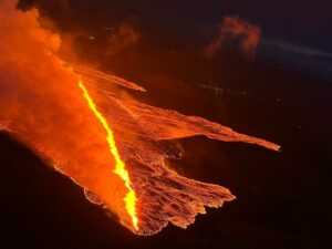
IMO reported that a small eruption in the western part of the Krýsuvík-Trölladyngja volcanic system, close to Fagradalsfjall on the Reykjanes Peninsula, began at around 2045 on 19 March. The eruption was first visible in webcam images and confirmed by satellite data, and an orange glow in clouds on the horizon was seen from Reykjanesbaer and Grindavík (10 km SW). The Aviation Color Code was raised to Red. Reykjanesbraut, the main road from the capital region to Reykjanesbaer and the international airport at Keflavík, was closed.
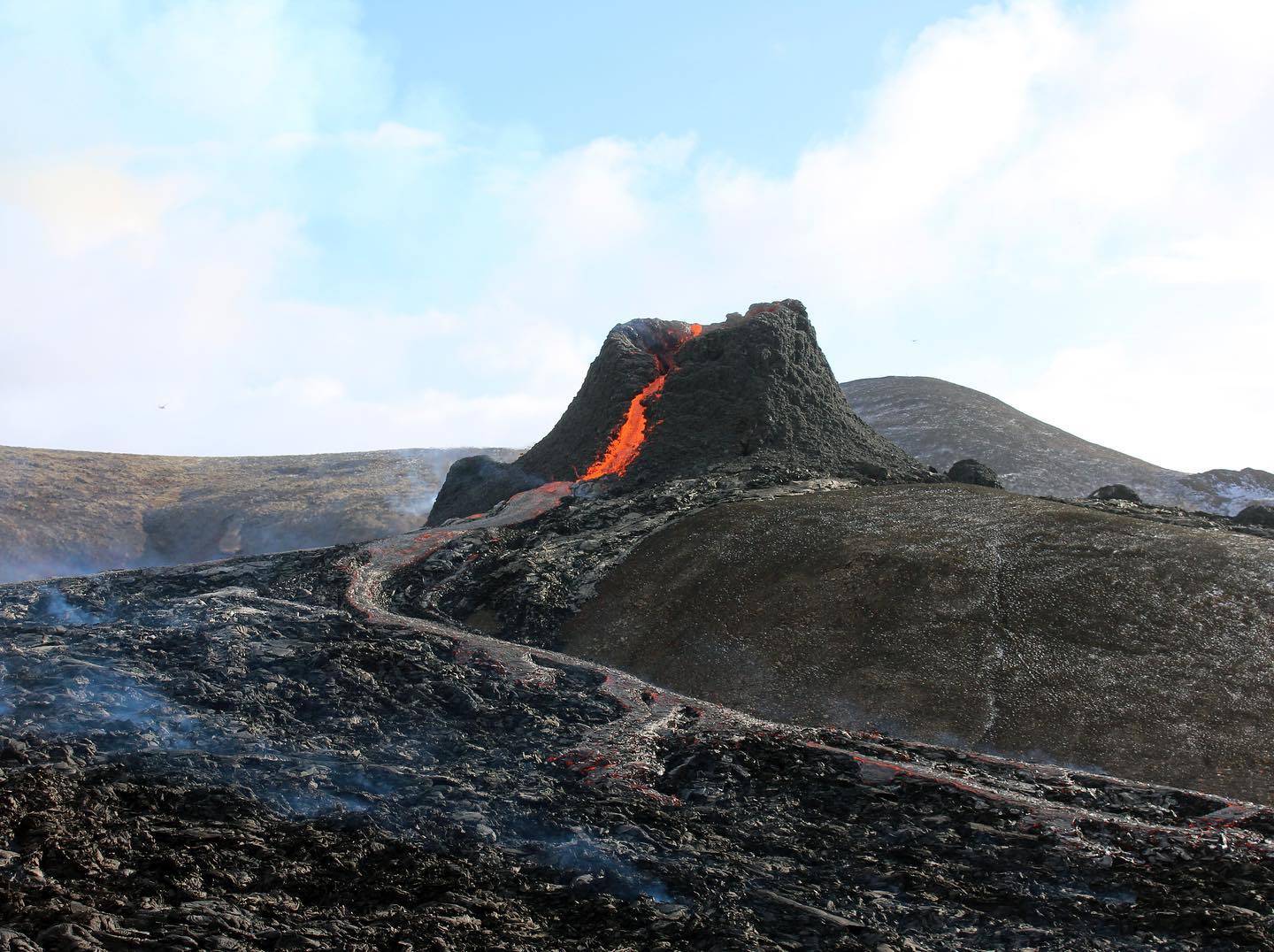
A fissure, 500-700 m long, had opened on a slope in the Geldingadalur valley about 4.7 km N of the coast and just off the SE flank of Fagradalsfjall mountain. Small lava fountains rose as high as 100 m above the fissure, and by 1110 on 20 March, the lava had covered an area less than 1 square kilometer and was approximately 500 m across. The extrusion rate was an estimated 5 cubic meters per second. The Aviation Color Code was lowered to Orange because there was little to no ash production that would affect aircraft. Reykjanesbraut reopened, but Sudurstrandarvegur, the road along the S coastline, was closed between Grindavík and Thorlakshofn.
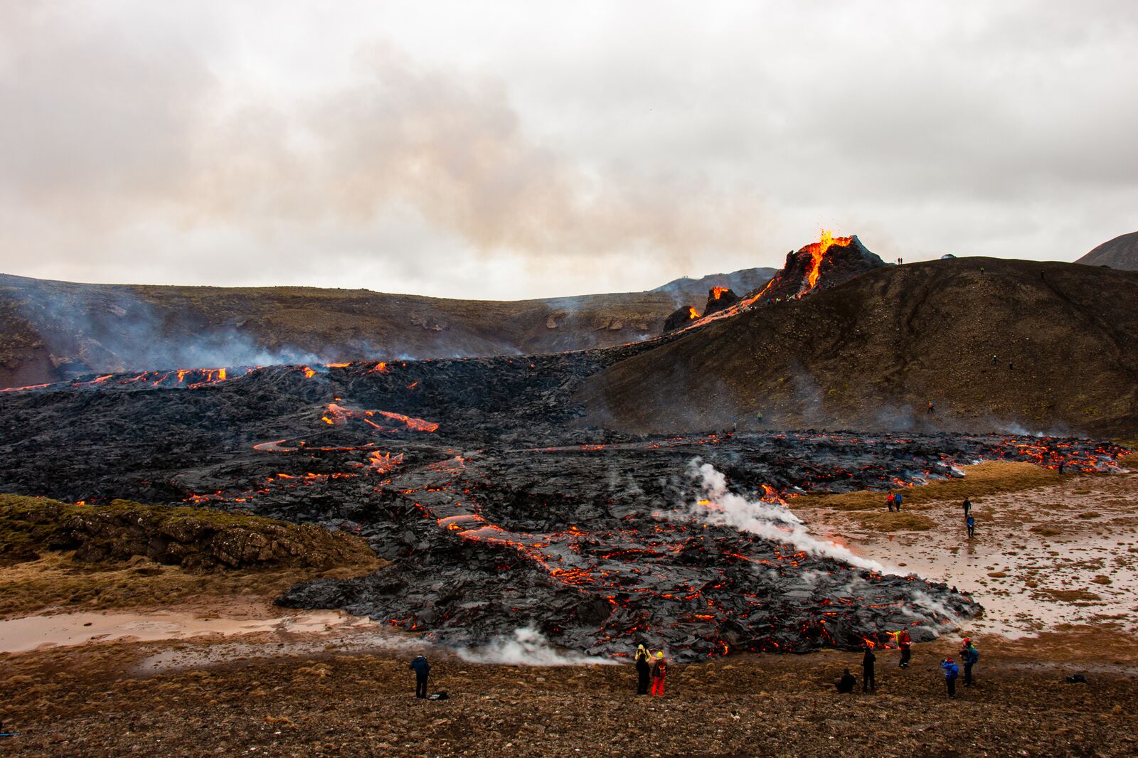
The eruption continued during 21-23 March with a consistent extrusion rate. About three cones had formed along the fissure; the tallest and widest was situated at the higher part of the fissure. Lava flows, mainly from the largest cone, fanned out to the NW, W, and SW, and also flowed S and fanned out to the E. Spatter was ejected above the cones. Video captured by visitors showed parts of the largest cone collapsing and rebuilding. The IMO periodically issued warnings about weather conditions that would cause high concentrations of volcanic gases to settle near the eruption site, causing hazardous conditions for visitors. IMO noted that through the night of 22-23 March night sulfur dioxide levels in Reykjavík had increased, though not to unsafe levels.
Source : GVP , IMO
Photos : Háskóli Íslands , Association France-Islande .
Alaska , Veniaminof :
56°11’52 » N 159°23’35 » W,
Summit Elevation 8225 ft (2507 m)
Current Volcano Alert Level: WATCH
Current Aviation Color Code: ORANGE
Low-level eruptive activity continues at Veniaminof. Seismicity has fluctuated over the past day, peaking in amplitude from about 7 pm to midnight AKDT, before declining to low levels this morning. Frequent explosive booming (several per minute) was reported by residents in Perryville (21 miles, 35 km southeast) and Chignik Lagoon (34 miles, 55 km northeast) during this period of peak seismicity. Airwaves from explosions were observed in local seismic data and on distant Infrasound networks over the past day.
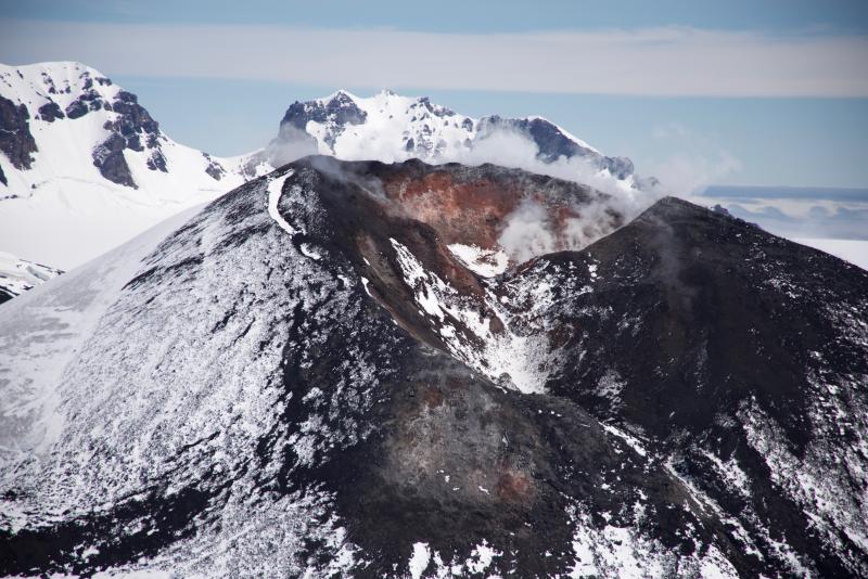
Thick cloud cover obscured satellite observations during this time of elevated seismicity and the FAA web camera in Perryville remains offline. However the peak seismic amplitude was about 30% of that observed in November 2019 during a period of intense ash emissions. Highly elevated surface temperatures were observed in satellite data during periods of clear weather yesterday, indicating continued eruption of lava in the summit crater. Ash deposits were also observed in satellite data from yesterday afternoon, and were primarily confined to the summit and upper flanks of the volcano.
Eruptive activity at Veniaminof usually consists of minor ash emissions, lava fountaining and lava flows from the small cone in the summit caldera. Ash emissions are typically confined to the summit crater, but larger events can result in ash fall in nearby communities and drifting airborne ash.
Source : AVO.
Photo : Read, Cyrus
Chile , Laguna del Maule :
SERNAGEOMIN reported that during 1-15 March the seismic network at Laguna del Maule recorded a total of 123 volcano-tectonic earthquakes. The largest event was a local M 2.4 located 8.2 km WSW of the lake, at a depth of 4.4 km. One tremor event was also recorded. Recent carbon dioxide emission measurements showed an upward trend and that the area of anomalous emissions had expanded. Deformation rates were higher than maximum averages. The Alert Level remained at Yellow, the second lowest level on a four-color scale. ONEMI maintained a Yellow Alert for San Clemente and recommended restricted access within a radius of 2 km from the center of elevated carbon dioxide emissions.

For the period evaluated, the seismic activity associated with rock fracturing (VT) showed an increase compared to the previous fortnight.
The event with the highest energy recorded had a local magnitude (ML) of 2.4 and was located 8.2 km west-southwest (OSW) of the center of the lagoon with a depth of 4.4 km.
Data from GNSS stations allowed us to observe that the deformation process continues with heave rates equivalent to the average recorded since 2012. The highest heave rate of the last 30 days is 1.1 cm / month in the station closest to the deformation center. A change in the direction of the horizontal displacement was recorded at the station closest to the zone of maximum deformation, possibly related to a migration of the source.
Surveillance camera images did not report surface activity associated with the volcanic complex.
Studies of diffuse soil carbon dioxide (CO₂) indicate that the upward trend in CO₂ fluxes since 2019 and an extension of the anomaly continues.
Source : GVP , Segemar .
Photo : Dr Katie Keranen.