January 29 , 2021.
Kamchatka , Klyuchevskoy :
VOLCANO OBSERVATORY NOTICE FOR AVIATION (VONA).
Issued: January 29 , 2021
Volcano: Klyuchevskoy (CAVW #300260)
Current aviation colour code: ORANGE
Previous aviation colour code: orange
Source: KVERT
Notice Number: 2021-17
Volcano Location: N 56 deg 3 min E 160 deg 38 min
Area: Kamchatka, Russia
Summit Elevation: 4750 m (15580 ft)
Volcanic Activity Summary:
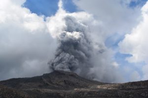
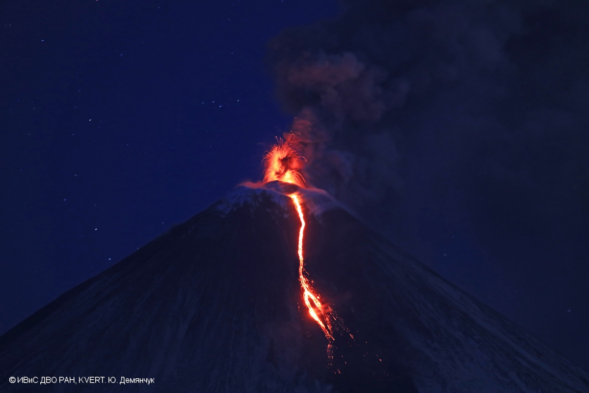
A moderate explosive-effusive eruption of the volcano continues. According to video and satellite data, a gas-steam plume with some amount of ash is extending for 92 km to the east of the volcano.
A moderate explosive-effusive eruption of the volcano continues. Ash explosions up to 9-10 km (29,500-32,800 ft) a.s.l. could occur at any time. Ongoing activity could affect international and low-flying aircraft.
Volcanic cloud height:
5800-6000 m (19024-19680 ft) AMSL Time and method of ash plume/cloud height determination: 20210129/0250Z – Video data
Other volcanic cloud information:
Distance of ash plume/cloud of the volcano: 92 km (57 mi)
Direction of drift of ash plume/cloud of the volcano: E / azimuth 83 deg
Time and method of ash plume/cloud determination: 20210129/0220Z – Himawari-8
Source : Kvert.
Photo : Yu .Demyanchuk. IVS FEB RAS, KVERT
Hawaii , Kilauea :
19°25’16 » N 155°17’13 » W,
Summit Elevation 4091 ft (1247 m)
Current Volcano Alert Level: WATCH
Current Aviation Color Code: ORANGE
Activity Summary:
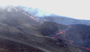
Kīlauea Volcano is erupting. Lava activity is confined to Halemaʻumaʻu with lava erupting from a vent on the northwest side of the crater. As of the morning of January 28 lava has filled about 208 m (684 ft) of Halemaʻumaʻu and only the western portion of the lava lake is active. SO2 emission rates remain elevated
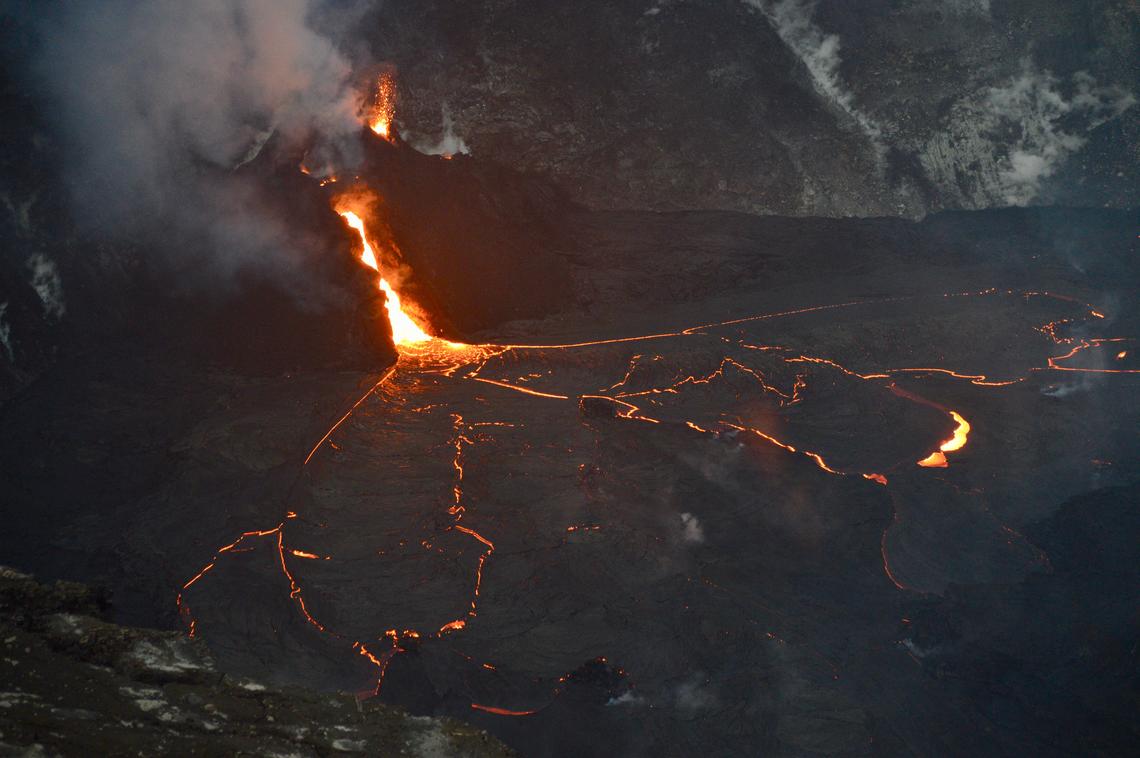
Activity at the west vent within Halemaʻumaʻu crater on January 22 included frequent spattering from multiple locations and an open lava channel which drops 20 meters (65 feet) from its source to the lava lake surface. HVO scientists continue to monitor Kīlauea’s summit eruption from within an area of Hawai‘i Volcanoes National Park that remains closed to the public for safety reasons.
Summit Observations:
The most recent sulfur dioxide emission rate measurements from January 23, are about 2,200 t/d—lower than the emission rates from the pre-2018 lava lake (3,000–6,500 t/d). The summit tiltmeters are on an inflationary trend. Seismicity remains elevated but stable, with steady elevated tremor and a few minor earthquakes.
Halemaʻumaʻu lava lake Observations:
Lava from the west vent continues to supply Halema‘uma‘u crater with lava. Recently, effusion rates have correlated positively with inflationary tilt at Kīlauea’s summit.
During evening observations on January 27, 2021, lava was measured as having filled 209 m (685 feet) of Halemaʻumaʻu in the active western portion. The stagnant eastern area of the lake remains about 5 m (15 feet) lower than the perched, elevated, and active western portion. Lava activity in the western portion consisted of slow surface movement at the base of the west vent lava stream and overturning of the crust near crust margins.
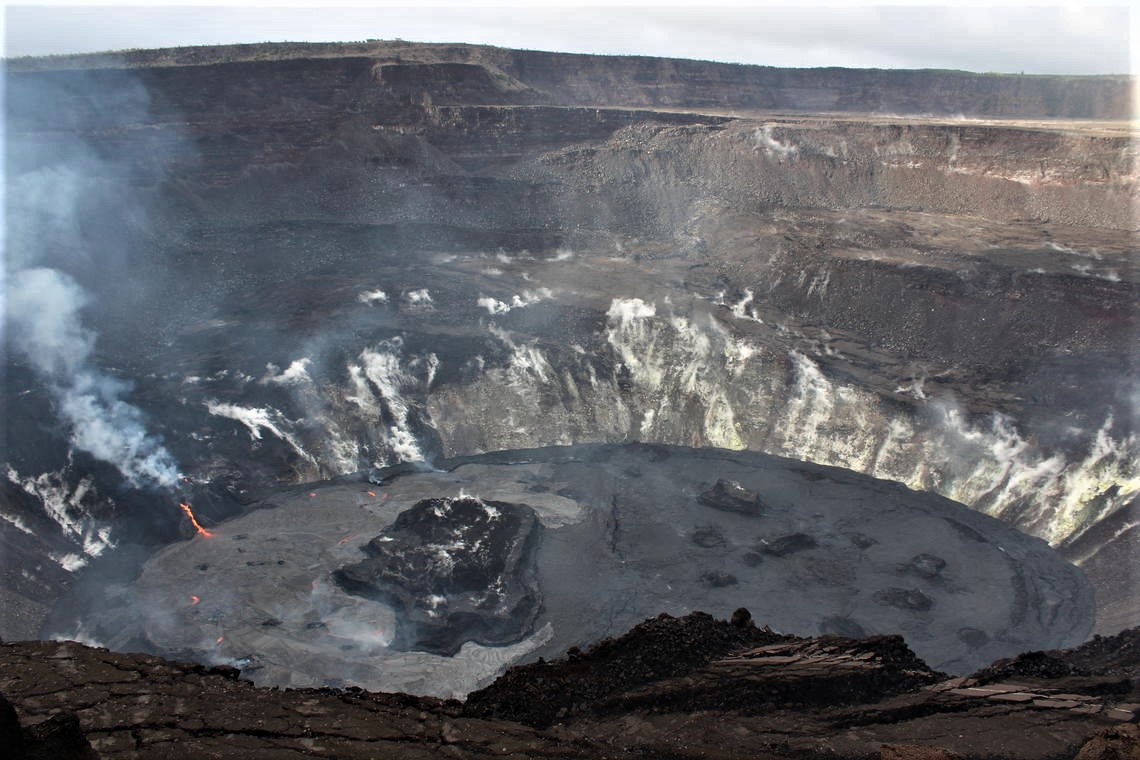
HVO scientists observed the Halema‘uma‘u lava lake from the southern crater rim in the late afternoon on Tuesday. In this view, the active western fissure at Kīlauea’s summit is visible to the left. The circulating western portion (left) of the lava lake has a more silvery color than the stagnant eastern portion (right). Several of the islands in the lake, including the largest one, are seen here.
All the islands have been stationary since approximately January 10, 2021, frozen in the stagnant central and eastern areas of the lava lake. The dimensions of the main island remained unchanged with its edges several meters (yards) above the lake surface. On January 22, the south end of the island was measured at 12 m (39 ft) above the lava lake surface, with the highest point at 23 m (75 ft) above the surface; a field crew on January 27 did not observe any significant rise or drop relative to the lake surface.
Source : HVO.
Photos : USGS / B. Carr , USGS / M. Zoeller.
Indonesia , Raung :
VOLCANO OBSERVATORY NOTICE FOR AVIATION – VONA.
Issued : January 27 , 2021
Volcano : Raung (263340)
Current Aviation Colour Code : ORANGE
Previous Aviation Colour Code : orange
Source : Raung Volcano Observatory
Notice Number : 2021RAU10
Volcano Location : S 08 deg 07 min 30 sec E 114 deg 02 min 31 sec
Area : East java, Indonesia
Summit Elevation : 10662 FT (3332 M)
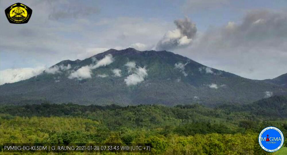
Volcanic Activity Summary :
Eruption with volcanic ash cloud 19:35 UTC ( 02:35 Local Time ), Eruption and ash emission is continuing.
Volcanic Cloud Height :
Best estimate of ash-cloud top is around 12902 FT (4032 M) above sea level, may be higher than what can be observed clearly. Source of height data: ground observer.
Other Volcanic Cloud Information :
Ash moving to East-Southeast
Remarks :
Seismic activity is characterized by volcanic tremor.
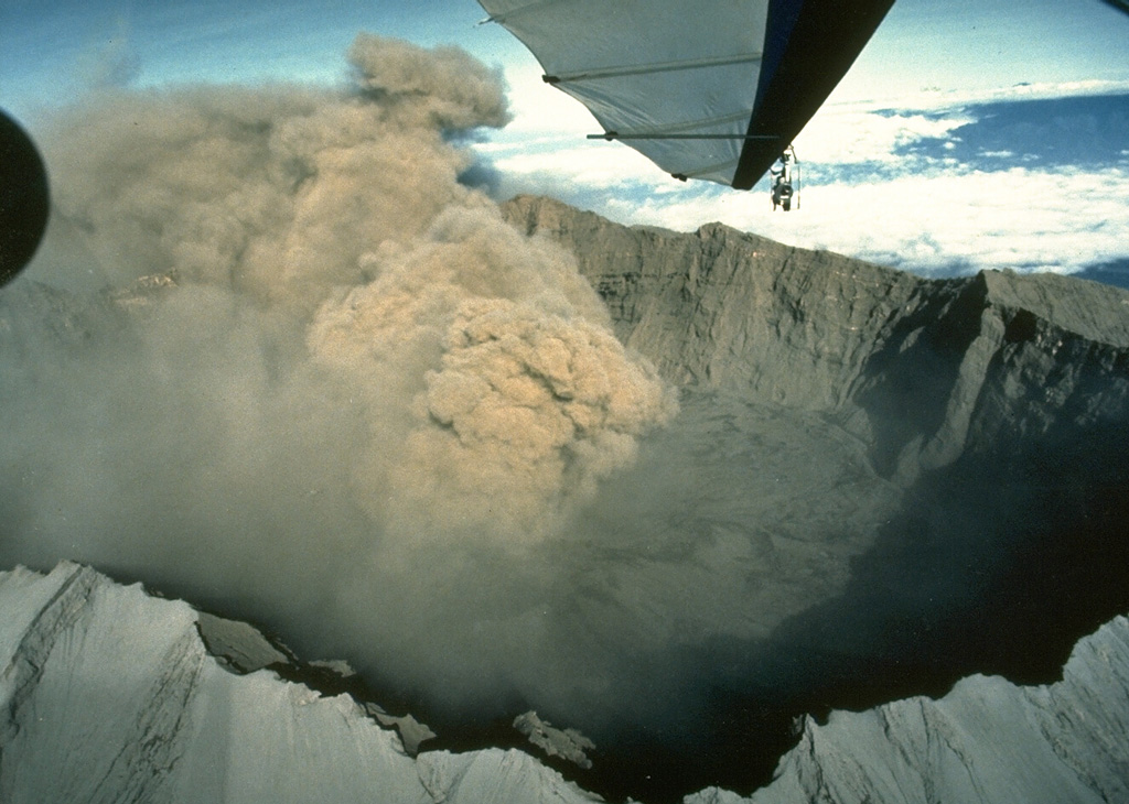
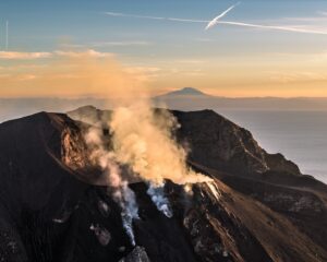
An ash plume from the scoria cone within the caldera rises above the rim of the 2-km-wide Raung caldera in July 1988. Raung has erupted frequently in historical time.
Since January 20, 2021, non-harmonic tremors have been recorded, followed by deep volcanic earthquakes, accompanied by changes in height and color of the emission gas / ash column. Thus, since January 21, 2021, the activity level of G. Raung has been raised to level II (Waspada).
The volcano was clearly visible until it was covered in fog. The gray and brown smoke emitted by the crater was observed with a low to medium intensity about 700 meters above the summit. The weather is sunny to rainy, the winds weak to strong in the North-East and in the South. There was an incandescence and a roar and ashes moving East, Southeast, Northeast.
According to the seismographs of January 28, 2021, it was recorded:
• 1 emission earthquake.
• 229 non-harmonic tremors
• 2 distant tectonic earthquakes
Source : Magma Indonésie , PVMBG.
Photos : Magma , Willem Rohi, 1988 (Volcanological Survey of Indonesia).
Ecuador , Reventador :
DAILY REPORT OF THE STATE OF THE REVENTADOR VOLCANO, Thursday January 28, 2021.
Information Geophysical Institute – EPN.
Surface activity level: High, Surface trend: Increasing.
Internal activity level: High, Internal trend: No change.
Seismicity: From January 27, 2021, 11: 00h to January 28, 2021, 11: 00h:
Explosions (EXP): 101 events
Long period type events (LP): 85
Tremor of emissions (TREMI): 9
Harmonic tremor (TRARM): 6
Rains / lahars: The rains in the region, did not generate lahars.
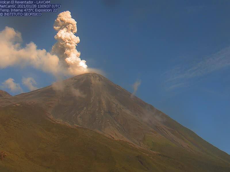
Emission / ash column: During the last 24 hours, several ash emissions were observed towards the West and North-West, their heights varied between 300 and 1000 meters above the level of the crater. The Washington VAAC published 2 reports of emissions observed through satellite monitoring and which remained in a westerly direction, the heights of which varied between 700 and 1000 meters above crater level.
Other monitoring parameters: FIRMS has logged 6 thermal alerts on the Reventador in the last 24 hours.
Observations: The volcano was mostly clear from late afternoon yesterday until part of the morning today. Described gas and ash emissions were observed, and nocturnal explosions, incandescence in the crater and rolling boulders were observed up to 600 meters below crater level on the northeast and south flanks. In addition, for a few days, a new lava flow was observed descending from the northern vent of the crater.
Niveau d’alerte: Orange.
Source et photos : IGEPN.