January 22 , 2021 .
Kamchatka , Klyuchevskoy :
56.06 N, 160.64 E;
Elevation 4750 m (15580 ft)
Aviation Colour Code is ORANGE
A moderate explosive-effusive eruption of the volcano continues. Ash explosions up to 7-8 km (23,000-26,200 ft) a.s.l. could occur at any time. Ongoing activity could affect international and low-flying aircraft.
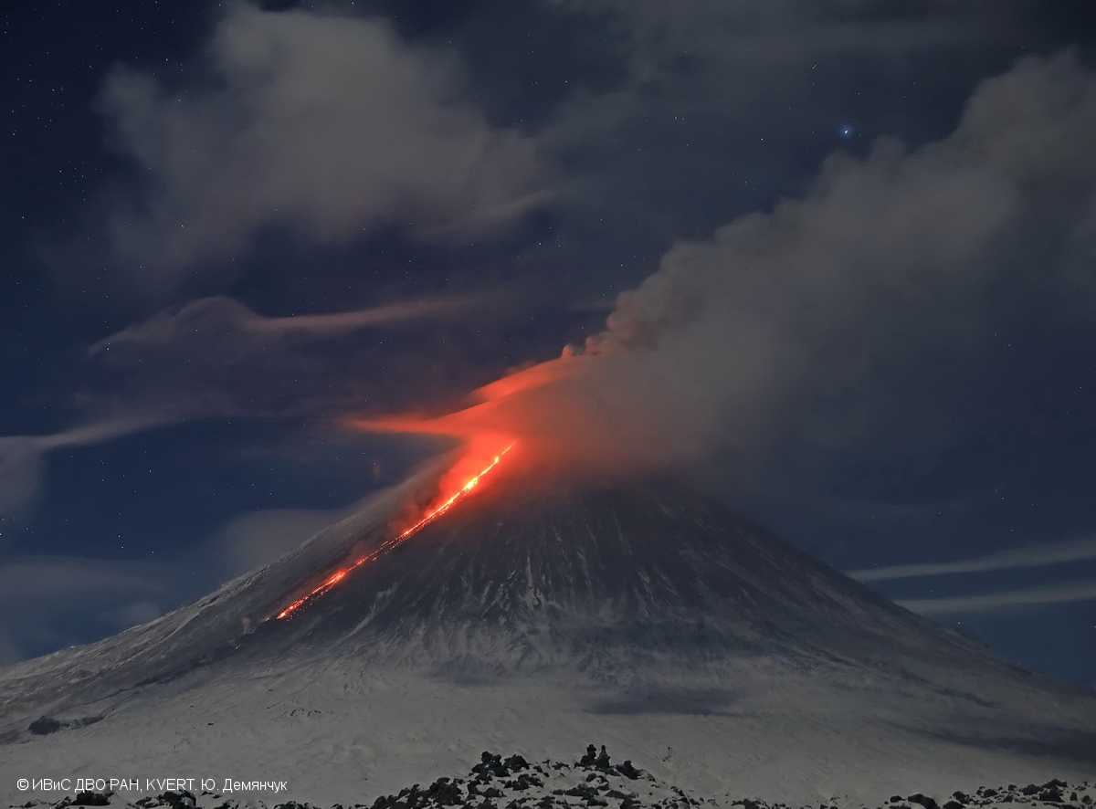
A moderate explosive-effusive eruption of the volcano continues, the Strombolian, gas-steam and sometimes Vulcanian activity is observing. The lava flows continue to move along Kozyrevsky and Apakhonchichsky chutes on the southern and southeastern volcanic flanks. Satellite data showed a large bright thermal anomaly in the area of the volcano all week. The strong paroxysmal event occurred on 18 January: explosions sent ash up to 7.5 km a.s.l., the eruptive cloud drifted for 500 km to the west of the volcano; the strong ashfall was observed in Kozyrevsk Village – the layer thickness of ash was 1 cm. In the other days of the week gas-steam plumes containing some amount of ash rose up to 6 km a.s.l., and extended for 200 km to the different directions of the volcano.
Source : Kvert.
Photo : Yu. Demyanchuk, IVS FEB RAS, KVERT
Hawaii , Kilauea :
19°25’16 » N 155°17’13 » W,
Summit Elevation 4091 ft (1247 m)
Current Volcano Alert Level: WATCH
Current Aviation Color Code: ORANGE
Activity Summary:
Kīlauea Volcano is erupting. Lava activity is confined to Halemaʻumaʻu with lava erupting from a vent on the northwest side of the crater. This morning, January 21, the lava lake was about 202 m (663 ft) deep and remains stagnant over its eastern half. SO2 emission rates remain elevated.
Summit Observations:
The most recent sulfur dioxide emission rate measurements from January 16, are about 2,500 t/d—lower than the emission rates from the pre-2018 lava lake (3,000–6,500 t/d). The summit tiltmeters are on a deflationary trend; the rate of deflation is slowing. Seismicity remains elevated but stable, with steady elevated tremor and a few minor earthquakes.
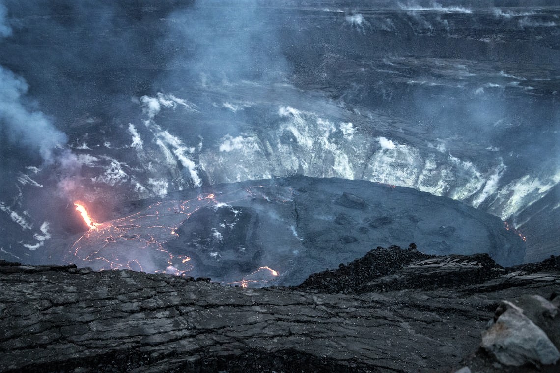
This photo, taken at just after 6 p.m. HST on January 19, shows that the western fissure continues to send lava into Halemʻaumaʻu crater through an open channel into the lava lake. The western side of the lava lake has an incandescent surface, while the eastern portion is more crusted over. However, lava continues to flow beneath this eastern portion, supplying breakouts visible as incandescent regions on the northeastern and eastern margins of the lava lake. Photo taken from the south rim of Halemʻaumaʻu at Kīlauea’s summit, and faces northwest.
Halemaʻumaʻu lava lake Observations:
Low fountaining from the west vent supplies a channel of lava which is pouring into the lava lake within Halema‘uma‘u crater.
The active western half of the lava lake was about 202 m (663 ft) deep this morning (Jan. 21) while the stagnant eastern half of the lake remains several meters (yards) lower. The whole lava lake—including the stagnant eastern half—is perched/elevated at least 1–2 m (yards) above the crust between the perched lake and the crater wall.
All the islands have been stationary over the past week, frozen in the eastern stagnant portion of the lava lake. The dimensions of the main island remained unchanged with its edges several meters (yards) above the lake surface. On January 12, the west end of the island was measured at 8 m (26 ft) above the lava lake surface, with the highest point at 23 m (75 ft) above the surface.
Source : HVO.
Photo : USGS photo by. H. Dietterich.
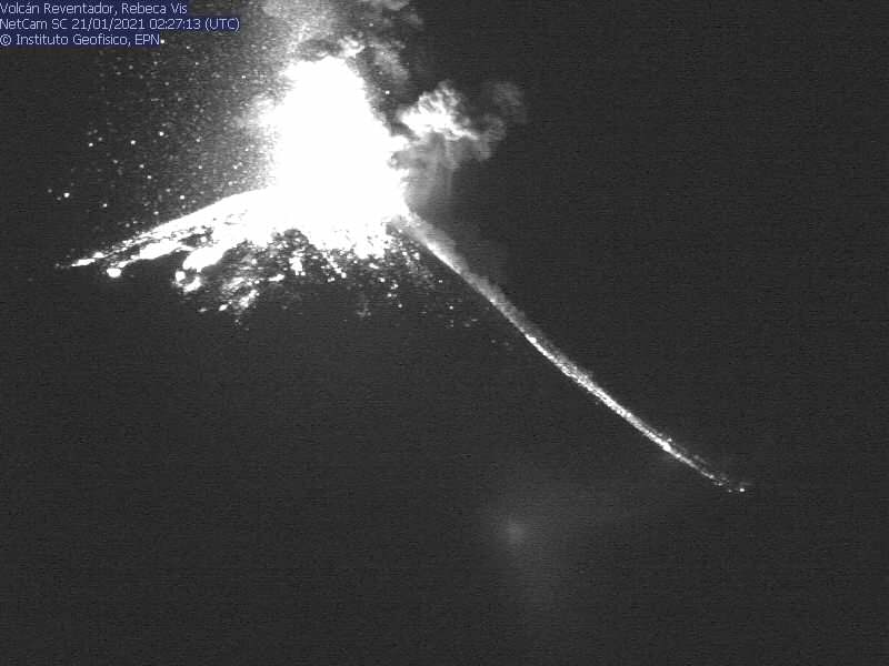
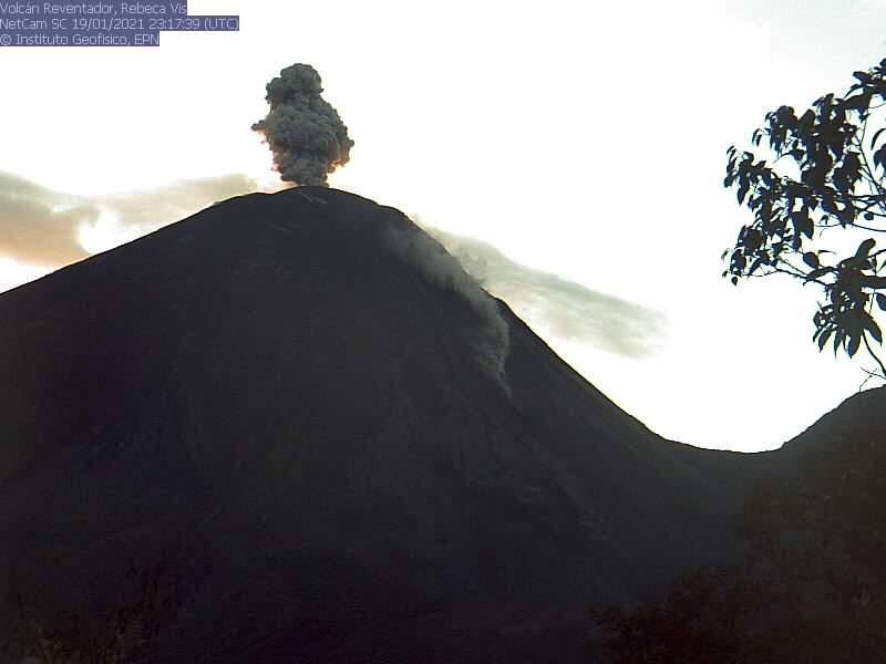
Ecuador , Reventador :
DAILY REPORT OF THE STATE OF THE REVENTADOR VOLCANO, Thursday January 21, 2021.
Information Geophysical Institute – EPN.
Surface activity level: High, Surface trend: Increasing.
Internal activity level: High, Internal trend: No change.
Seismicity: From January 20, 2021, 11: 00h to January 21, 2021, 11: 00h:
Explosions (EXP): 91 events
Long period type events (LP): 97
Emission tremor (TREMI): 25
Harmonic tremor (TRARM): 3
Rains / lahars: No rains were recorded in the area.
Emission / ash column: During the last 24 hours, several ash emissions have been observed with a westerly direction, heights around 800 and 1000 meters above the crater level. The Washington VAAC reported 4 alerts of emissions observed by the satellites, their direction was maintained in the West and the heights did not exceed 1000 meters above the level of the crater.
Other monitoring parameters: FIRMS has recorded 1 thermal alert on the Reventador in the last 24 hours.
Mirova has recorded 1 moderate thermal alert on the Reventador in the last 24 hours.
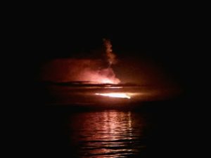
Observations: During the past 24 hours, most of the weather was clear, allowing us to observe the emissions already described. At night, explosions and incandescence were observed in the summit area accompanied by the rolling of blocks along the sides of the volcano. In addition, in recent days, a new emission of lava can be observed which descends from the northern vent of the crater.
Niveau d’alerte: Orange.
Source et photos : IGEPN.
Indonesia , Raung :
VOLCANO OBSERVATORY NOTICE FOR AVIATION – VONA.
Issued : January 22 , 2021
Volcano : Raung (263340)
Current Aviation Colour Code : ORANGE
Previous Aviation Colour Code : orange
Source : Raung Volcano Observatory
Notice Number : 2021RAU04
Volcano Location : S 08 deg 07 min 30 sec E 114 deg 02 min 31 sec
Area : East java, Indonesia
Summit Elevation : 10662 FT (3332 M)
Volcanic Activity Summary :
Eruption with volcanic ash cloud at 00h13 UTC (07h13 local). Eruption and ash emission is continuing.
Volcanic Cloud Height :
Best estimate of ash-cloud top is around 12262 FT (3832 M) above sea level, may be higher than what can be observed clearly. Source of height data: ground observer.

Other Volcanic Cloud Information :
Ash cloud moving to east.
Remarks :
Seismic activity is characterized by volcanic tremors.
Since January 20, 2021, non-harmonic discontinuous tremors have been recorded, followed by a deep volcanic earthquake, accompanied by changes in height and color of the emitted gas / ash column. Thus, since January 21, 2021, the activity level of G. Raung has been raised to level II (Waspada).
The volcano was clearly visible until it was covered in fog. The smoke from the crater was observed to be gray-brown in color, of moderate intensity, 100 to 400 m in height above the summit crater. The weather is sunny, cloudy and rainy, the winds are weak in the North and South. Air temperature 19-42 ° C
According to the seismographs of January 21, 2021, it was recorded:
38 emission earthquakes
138 non-harmonic tremors
4 distant tectonic earthquakes.
Source : Magma Indonésie , PVMBG.
Photo : wikimapia.