January 12 , 2021 .
Hawaii , Kilauea :
19°25’16 » N 155°17’13 » W,
Summit Elevation 4091 ft (1247 m)
Current Volcano Alert Level: WATCH
Current Aviation Color Code: ORANGE
Activity Summary:
Lava activity is confined to Halemaʻumaʻu with lava erupting from vents on the northwest side of the crater. This morning (Jan. 10), the lava lake is about 196 m (643 ft) deep below the west vents while remaining stagnant over its eastern half. SO2 emission rates were still elevated.
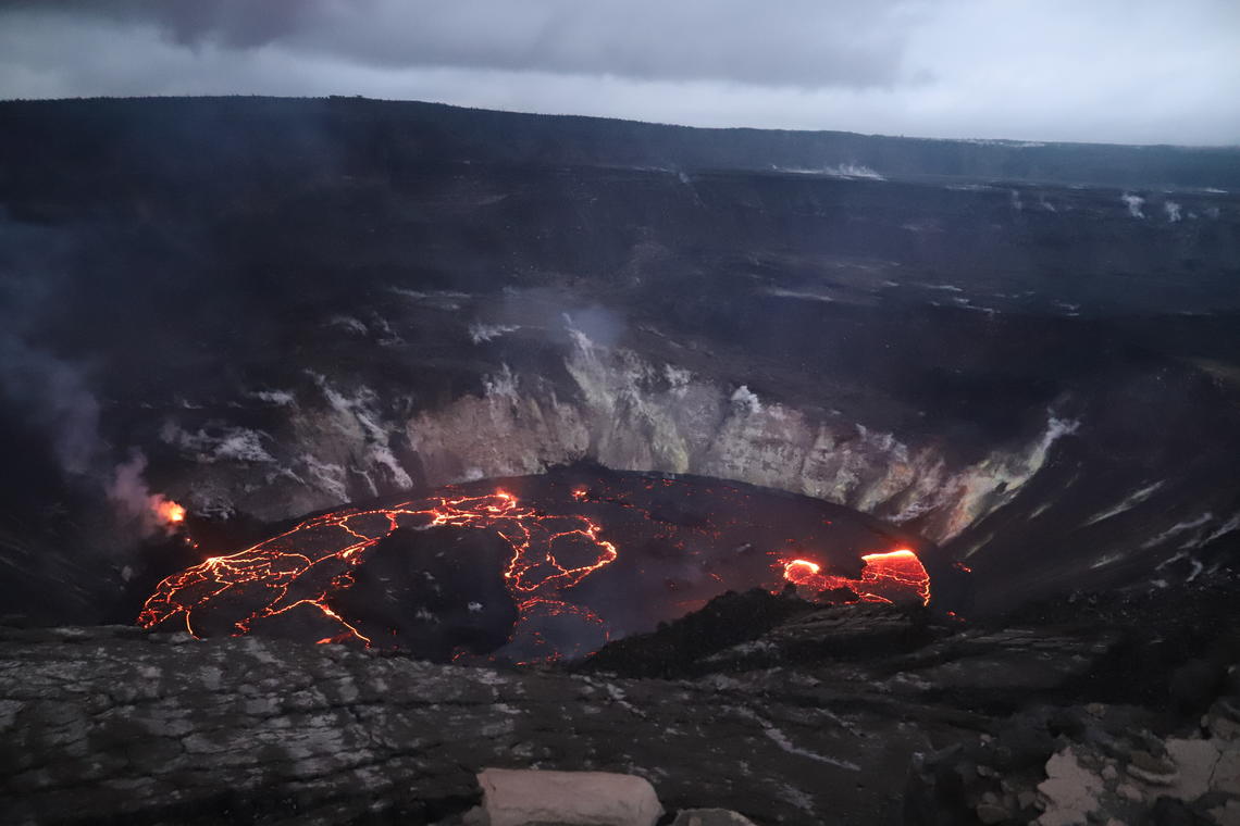
Kīlauea’s summit lava lake, in Halema‘uma‘u, just after sunset on January 8, 2021. This view is to the north, from the south rim of the crater. HVO scientists continue to monitor the eruption within an area of Hawai‘i Volcanoes National Park that remains closed to the public for safety reasons.
Summit Observations:
The most recent sulfur dioxide emission rate measurements were 2,300 t/d on Sunday (Jan. 10) and 2,700 t/d on Thursday (Jan 7)– with uncertainties of about 700 t/d, these values are on the low end of the range 3,000-6,500 t/d since Dec. 27 (the same range of emission rates from the pre-2018 lava lake). Summit tiltmeters recorded continuing inflationary tilt. Seismicity remained elevated but stable, with steady elevated tremor and a few minor earthquakes.
East Rift Zone Observations:
SO2 and H2S emissions from Puʻu ʻŌʻō were below instrumental detection levels when measured on Jan. 7.
Halemaʻumaʻu lava lake Observations:
The west vents exhibited stronger flow starting yesterday afternoon with spattering and spatter-fed lava flows from the top of small cones plastered on the northwest wall of Halemaʻumaʻu crater. Lava also flowed from the west vents through a crusted channel into the lake.
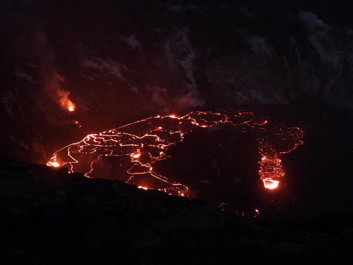
The arrival of nightfall at Halema‘uma‘u on January 9, 2021, provided a clearer view of ongoing eruptive activity for USGS scientists monitoring the eruption Saturday evening. This photo is focused on areas of active crustal motion in the western half of the lava lake; the eastern half (off to the right) is mostly stagnated and displays significantly less incandescence. The west vent, still actively effusing lava but at a diminishing rate, is visible to the upper left of the lake.
The lava lake was about 196 m (643 ft or 214 yds) deep below the west vents this morning (Jan. 11) while the stagnant eastern half of the lake was about 3-4 m (3-4 yds) shallower. Last night (Jan. 10) the eastern part of the lake appeared to have subsided below its perched rims. Overall, the dimension of the lake remained the same. The lake was still perched at least 1-2 m (1-2 yds) above its narrow edges even though the eastern half of the lake appeared stagnant this morning.
All islands were stationary over the past day as if frozen in the eastern stagnant portions of the lava lake. The dimensions of the main island remained unchanged with its edges several meters (yards) above the lake surface.
Source : HVO.
Photos : USGS image by N. Deligne. USGS photo by H. Dietterich.
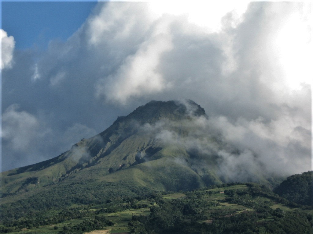
Martinique , Montagne Pelée :
Weekly report on the activity of Mount Pelée for the period from January 01, 2021 to January 08, 2021.
The seismicity of volcanic origin began a new period of increase since January 01, 2021. None of these earthquakes were felt by the population.
Between January 01, 2021 4 p.m. UT (local time + 4 hours) and January 8, 2021 4 p.m. UTC (local time + 4 hours), the OVSM recorded at least 65 volcano-tectonic earthquakes of magnitude less than or equal to 1 This volcano-tectonic seismicity associated with high frequency signals is linked to micro-fracturing in the volcanic edifice.
During the period of this report, the OVSM again recorded 249 long-period type volcanic seismic signals contained in a volcanic tremor type signal, distributed over two periods, between 00:00 / 02:00 on January 03 (for two hours) and between approximately 9:00 p.m. on January 03 and 2:00 a.m. on January 04 (for 5 hours). Two isolated long-period type earthquakes were also recorded. These signals containing low frequencies are associated with the migration of fluids in the volcanic edifice. As during the previous episode of volcanic tremor of November 8-9, 2020, the volcano-tectonic seismicity reappeared a few days after the observation of the volcanic tremor, i.e. from January 06.
During phases of volcanic reactivation, it is common for periods of higher seismic activity to alternate with phases of weaker seismicity. The seismicity of volcanic origin remains however clearly above the average base level recorded between January 1, 2015 and April 2019 (date of the start of its increase).
The occurrence of a new period of a few hours of volcanic tremor with low frequencies clearly indicates a disturbance of the hydrothermal system (area inside the volcanic edifice of interaction between hot magmatic gases and fluids, water infiltrated rain and rock), probably generated by the circulation of hot and pressurized fluids of hydrothermal and / or magmatic origin.
As a reminder, if the Pelée has been the subject of increased surveillance since the triggering of the yellow vigilance, the possibility of an eruption is not on the agenda.
Source : Direction de l’OVSM IPG.
Photo : Jmp48 / Wikipedia .
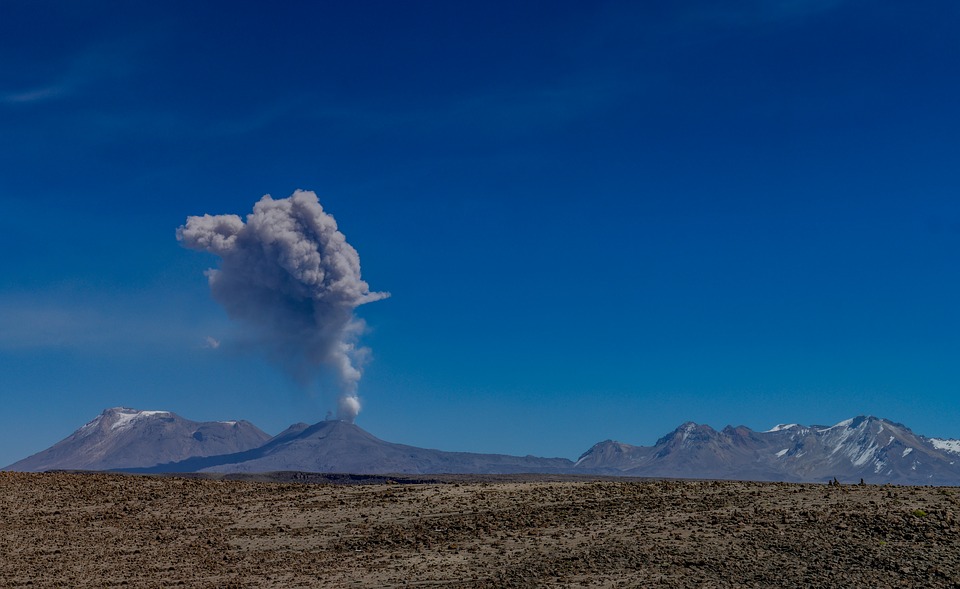
Peru , Sabancaya :
Analysis period: from January 04, 2021 to January 10, 2021, Arequipa, January 11, 2021.
Alert level: ORANGE
The Geophysical Institute of Peru (IGP) reports that the eruptive activity of the Sabancaya volcano remains at moderate levels, that is, with the continuous recording of explosions with columns of ash and gas up to 3 km of altitude above the summit of the volcano and their consecutive dispersion. It has been reported the presence of a second lava dome, visible in the crater of the volcano. Therefore, for the following days, no significant change is expected in the eruptive activity.
The IGP recorded and analyzed the occurrence of 1701 earthquakes of volcanic origin, associated with the circulation of magmatic fluids inside the Sabancaya volcano. An average of 375 explosions were recorded daily of low to medium intensity. During this period, Volcano-Tectonic (VT) earthquakes associated with rock fractures were located mainly in the North-East and South-East of Sabancaya and presented magnitudes between M1.9 and M2.8. The most representative earthquake (M2.8) was recorded on January 04 at 2:36 a.m., 11 km northeast of Sabancaya and 9 km deep.
The monitoring of the deformation of the volcanic structure using GNSS techniques (processed with fast orbits) does not present any significant anomalies. However, in general, an inflation process has been observed in the south-eastern sector of Sabancaya and in the north sector (Hualca Hualca volcano). Visual surveillance made it possible to identify columns of gas and ash up to 3 km altitude above the summit of the volcano, which were scattered towards the South, South-East, North-West, West and South sectors. Western Sabancaya. Satellite monitoring has identified the presence of 2 thermal anomalies, with values of 3 MW, associated with the presence of a lava dome on the surface of the volcano crater.
RECOMMENDATIONS
• Keep the volcanic alert level in orange.
• Do not approach within a radius of less than 12 km from the crater.
Source : IGP.
Photo : pixabay.
Costa Rica , Poas :
No eruption is reported.
Seismic activity is similar compared to yesterday.
At the time of this report, the winds are blowing west.
Seismicity remains stable with less than 150 daily events and occasional short-lived tremors of varying frequency. The degassing is constant through the orange fumarole on the northeast wall of the crater and the fumarolic sulfur field on the eastern edge of the lake. Volcanic gases remain at low levels and the CO2 / SO2 ratio remains close to 1. Deformation remains stable with a slight tendency towards inflation.
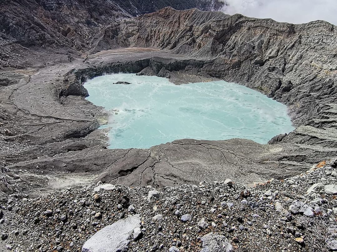
Poás volcano January 7, 2021. Hyperacid lake at 40 Celsius. The northeast or Orange fumarole reappears outside the lake in the interior northeast wall of the crater, at 80 Celsius, depositing native sulfur on the ground. This fumarole was active from 1999 to 2007.

FLIR SC660 infrared camera. OVSICORI-UNA.
The colors in the thermal image are wrong and represent areas with different temperatures measured by the infrared camera. The blue colors correspond to the colder zones, the colors between green and yellow to the zones of intermediate temperatures, the red and white zones are the hottest. Thus, the whitest areas are those with the highest temperatures.
Source et photos : Ovsicori .
Indonesia , Dukono :
VOLCANO OBSERVATORY NOTICE FOR AVIATION – VONA.
Issued : January 12 , 2021
Volcano : Dukono (268010)
Current Aviation Colour Code : ORANGE
Previous Aviation Colour Code : orange
Source : Dukono Volcano Observatory
Notice Number : 2021DUK04
Volcano Location : N 01 deg 41 min 35 sec E 127 deg 53 min 38 sec
Area : North Maluku, Indonesia
Summit Elevation : 3933 FT (1229 M)
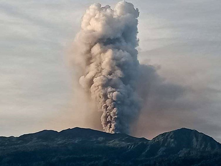
Volcanic Activity Summary :
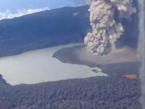
Eruption with volcanic ash cloud at 23h31 UTC (08h31 local).
Volcanic Cloud Height :
Best estimate of ash-cloud top is around 6173 FT (1929 M) above sea level, may be higher than what can be observed clearly. Source of height data: ground observer.
Other Volcanic Cloud Information :
Ash-cloud moving to north.
Remarks :
Eruption and ash emission is continuing.
Source : Magma Indonésie .
Photo : PGA