January 02 , 2021 .
Hawaii , Kilauea :
19°25’16 » N 155°17’13 » W,
Summit Elevation 4091 ft (1247 m)
Current Volcano Alert Level: WATCH
Current Aviation Color Code: ORANGE
Activity Summary:
Lava activity is confined to Halemaʻumaʻu with lava erupting from vents on the northwest side of the crater. Yesterday afternoon (Dec. 31), the lava lake was 186 m (610 ft) deep with a narrow black ledge around it. SO2 emission rates were still elevated.
The west vent area in Halema‘uma‘u wall continues to feed Kīlauea’s summit lava lake. Preliminary analysis of sulfur dioxide emission rates measured Wednesday (Dec. 30) show that the rates are about 3,800 tonnes/day– about the same as on the 28th and slightly lower than the Dec. 27 rate of 5,500 t/d, but still elevated; all three of the most recent emission rates were in the range of values common for the pre-2018 lava lake.
Summit Observations:
Sulfur dioxide emission rate measurements made yesterday (Dec. 31) were about 4500-5500 t/d and in the range 3,000-6,000 t/d since Sunday (Dec. 27)–the same range of values that was common for the pre-2018 lava lake. Summit tiltmeters continued to record neither inflationary nor deflationary tilt since Monday afternoon (Dec. 28). Seismicity remained elevated but stable, with steady elevated tremor and a few minor earthquakes.
East Rift Zone Observations:
Geodetic monitors indicate that the upper portion of the East Rift Zone (between the summit and Puʻu ʻŌʻō) contracted while the summit deflated. There is no seismic or deformation data to indicate that magma is moving into either of Kīlauea’s rift zones.
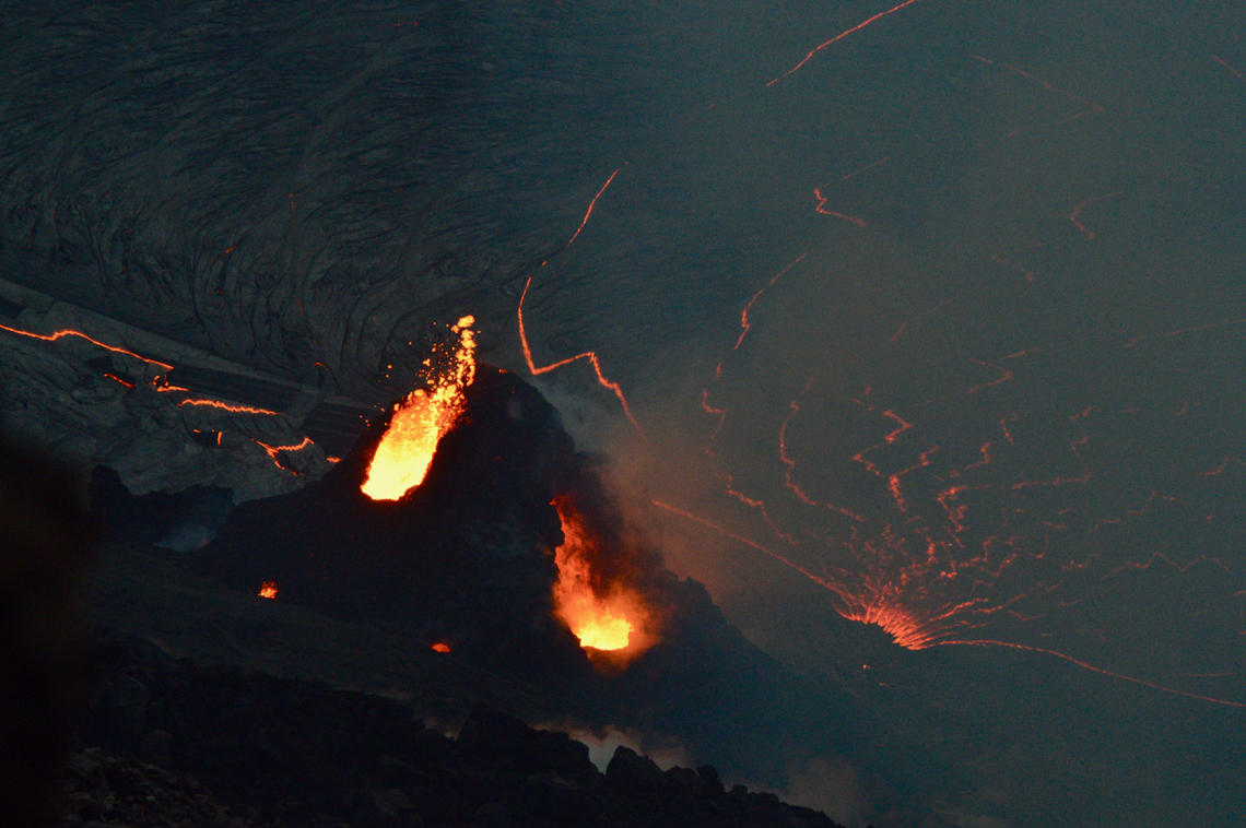
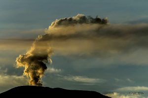
The western fissure in Halemaʻumaʻu wall remains active. Glowing vents and a prominent spatter cone are visible in this photo, which shows some spattering at the vent. This view looks steeply down from Kīlauea’s west caldera rim, and the lava lake surface is visible in the background.
Halemaʻumaʻu lava lake Observations:
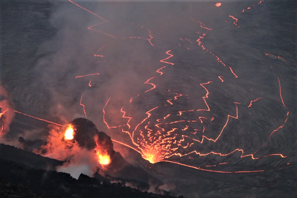
The west vents spattered while erupting lava flowed through crusted-over channels into a lava lake within Halemaʻumaʻu crater.
The lava lake continued to enlarge slowly and was 186 m (610 ft) deep yesterday afternoon (Dec. 31). The most recent thermal map (Dec. 30) provided the lake dimensions as 800 by 530 m (875 by 580 yds) for a total area of 33 ha (82 acres). The narrow (10-30 m or 11-22 yd) ledge around the lake was about 1-2 m (1-2 yds) above the active lake surface .
Over the past day, the main island of cooler, solidified lava floating in the lava lake moved more rapidly to the west, as if it were seeking out the west lava source filling the lake, while the other 10 or so small islands remained relatively stationary around the east end of the lake. The main island measured about 250 m (820 ft) in length, 135 m (440 ft) in width, and about 3 ha (7 acres) in area based on the Dec. 30 thermal map. Measurements Wednesday evening (Dec. 30) show that the island surface was about 6-8 m (20-26 ft) above the lake surface.
Source : HVO.
Photos : USGS photo by M. Patrick. USGS photo by B. Carr on 12/31/2020.
Kamchatka , Klyuchevskoy :
56.06 N, 160.64 E;
Elevation 15580 ft (4750 m)
Aviation Colour Code is ORANGE
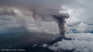
A moderate explosive-effusive eruption of the volcano continues. Ash explosions up to 23,000-26,200 ft (7-8 km) a.s.l. could occur at any time. Ongoing activity could affect international and low-flying aircraft.
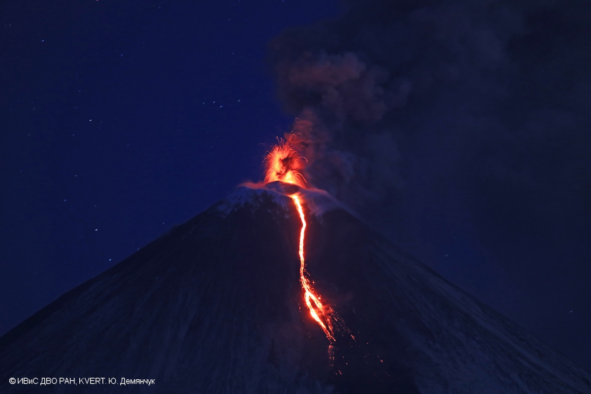
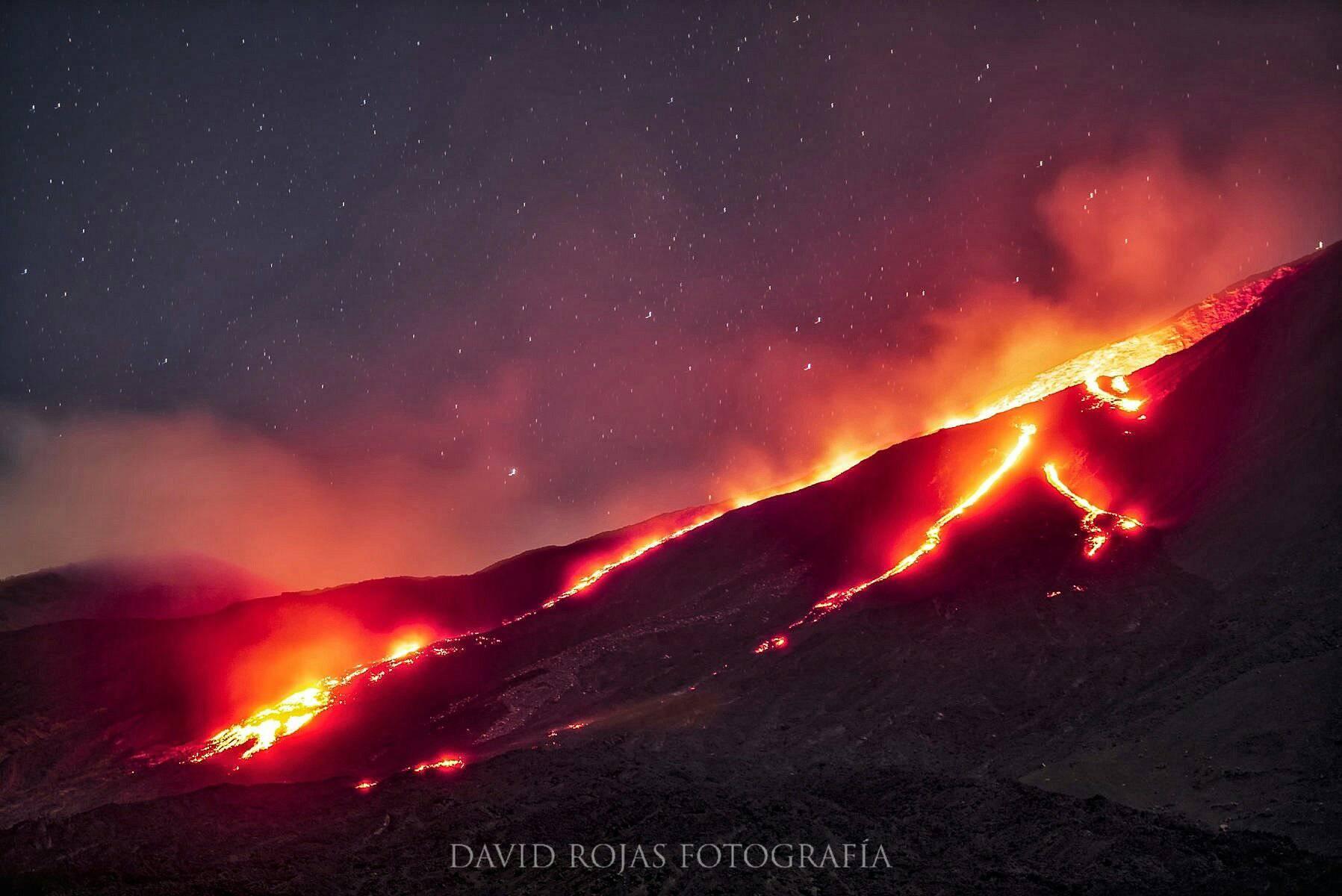
The explosive-effusive eruption of Klyuchevskoy volcano continues: there is notting its Strombolian and gas-steam activity, and the effusion of a lava flow along the southern slope.
A moderate explosive-effusive eruption of the volcano continues, the Strombolian and sometimes Vulcanian activity is observing. The lava flow continues to move along Kozyrevsky chute on the southern volcanic flank. Satellite data showed a large bright thermal anomaly in the area of the volcano all week; all week gas-steam plumes containing some amount of ash rose up to 6 km a.s.l., and extended for 250 km to the different directions of the volcano.
Source : Kvert .
Photo : Yu .Demyanchuk. IVS FEB RAS, KVERT.
Saint Vincent and the grenadines , Soufrière Saint Vincent :
LA SOUFRIERE BULLETIN 4- January 1, 2021. 6.00 PM
Alert level remains at Orange. The Volcano continues to exude magma on the surface and steam can still be observed from the Belmont Observatory. Persons living in areas close to the volcano which include communities from Fancy to Georgetown and Belle Isle to Richmond are asked to remain alert and listen to all advisories from the National Emergency Management Organisation (NEMO).
The three-person team from The University of the West Indies St. Augustine Campus (UWI-SRC) began work today having arrived in St. Vincent yesterday, to provide scientific support for the ongoing eruption at La Soufriѐre volcano. Led by Vincentian Geologist Prof. Richard Robertson, team spent most of today Friday, January 1 re-inspecting and upgrading all the seismic sites. A new GPS station was also installed at Georgetown. This new station will be able to detect signals from the volcano. Over the next few days work will focus on upgrading and installing other monitoring sites.
No aerial reconnaissance was done today as a result of the high wind advisory currently in effect for St. Vincent and the Grenadines.
Source : Nemo .
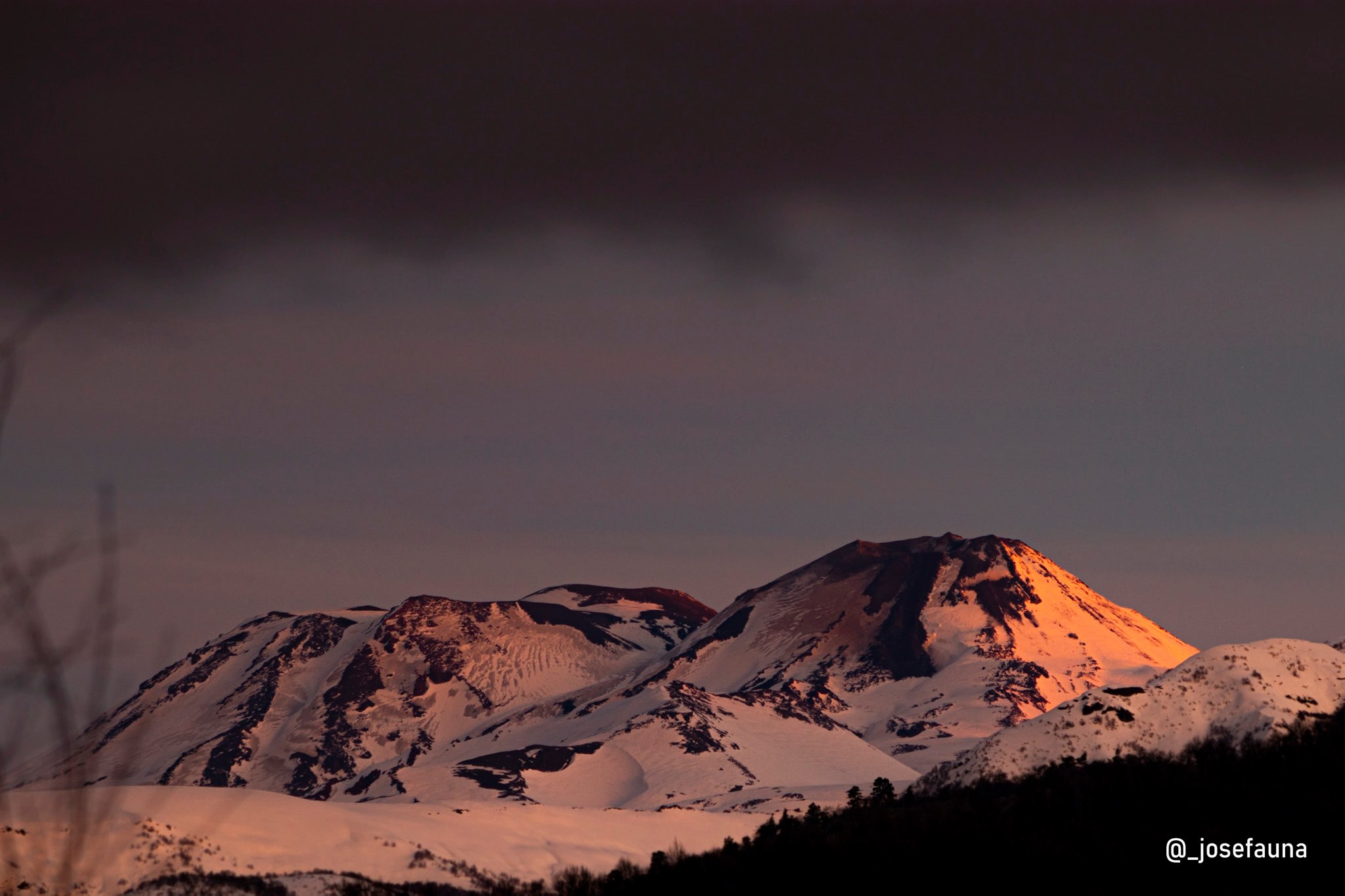
Chile , Nevados of Chillan :
Special Report on Volcanic Activity (REAV), Ñuble region, Nevados de Chillán volcanic complex, 01 January 2021, 19:10 local time (Continental Chile).
The National Service of Geology and Mines of Chile (Sernageomin) publishes the following PRELIMINARY information, obtained thanks to the monitoring equipment of the National Volcanic Monitoring Network (RNVV), processed and analyzed in the Volcanological Observatory of the Andes of the South (Ovdas):
On Friday January 01, 2021 at 10:43 a.m. local time (13:43 UTC), the monitoring stations installed near the Nevados de Chillán volcanic complex recorded an earthquake linked to rock fracturing (Volcano-Tectonic type).
The characteristics of the earthquake after its analysis are as follows:
TIME OF ORIGIN: 10:43 a.m. local time (13:43 UTC)
LATITUDE: 36.865 ° S
LONGITUDE: 71.364 ° W
DEPTH: 3.41 km
LOCAL MAGNITUDE: 3.7 (ML)
Observations:
The earthquake had no manifestation of surface activity. At the time of issue of this report, the seismicity maintained levels similar to those recorded before the event. There have been no reports from local communities on how this event was felt.
The volcanic technical alert remains at the Yellow level.
Source : Sernageomin .
Photo : Josefauna.
Guatemala , Pacaya :
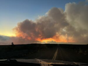
INCREASE IN EXPLOSIVE ACTIVITY, WITH FALL DOWN .
In the past few hours, the Pacaya’s eruptive pattern has changed, observing white and blue fumaroles with moderate and some strong explosions, expelling volcanic material 150 to 300 meters away. Ballistic projections are ejected out of the crater at a distance of 100 meters. This activity generates a constant degassing that resonates like a train locomotive with rumbles and shock waves that vibrate the roofs and windows of the houses of the villages around the volcano. The lava flow that began on October 20 in the crack on the southwest flank has slowed down considerably and is 100 meters long.
This activity is in the range of the Strombolian activity of the Pacaya, however in the next few hours the effusive activity may increase from the fissure or generate other lava flows. There is also the likelihood of increased explosive activity with ash emissions from the crater.
INSIVUMEH maintains seismic and visual monitoring through the seismic stations of PCG and PCG5 and OVPAC, for any change or increase in activity that can be observed or recorded.
Source : Insivumeh.
Photo : David Rojas