December 20 , 2020.
Italy / Sicily , Etna :
ETNA COMMUNICATION [UPDATE n. 100]
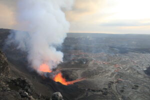
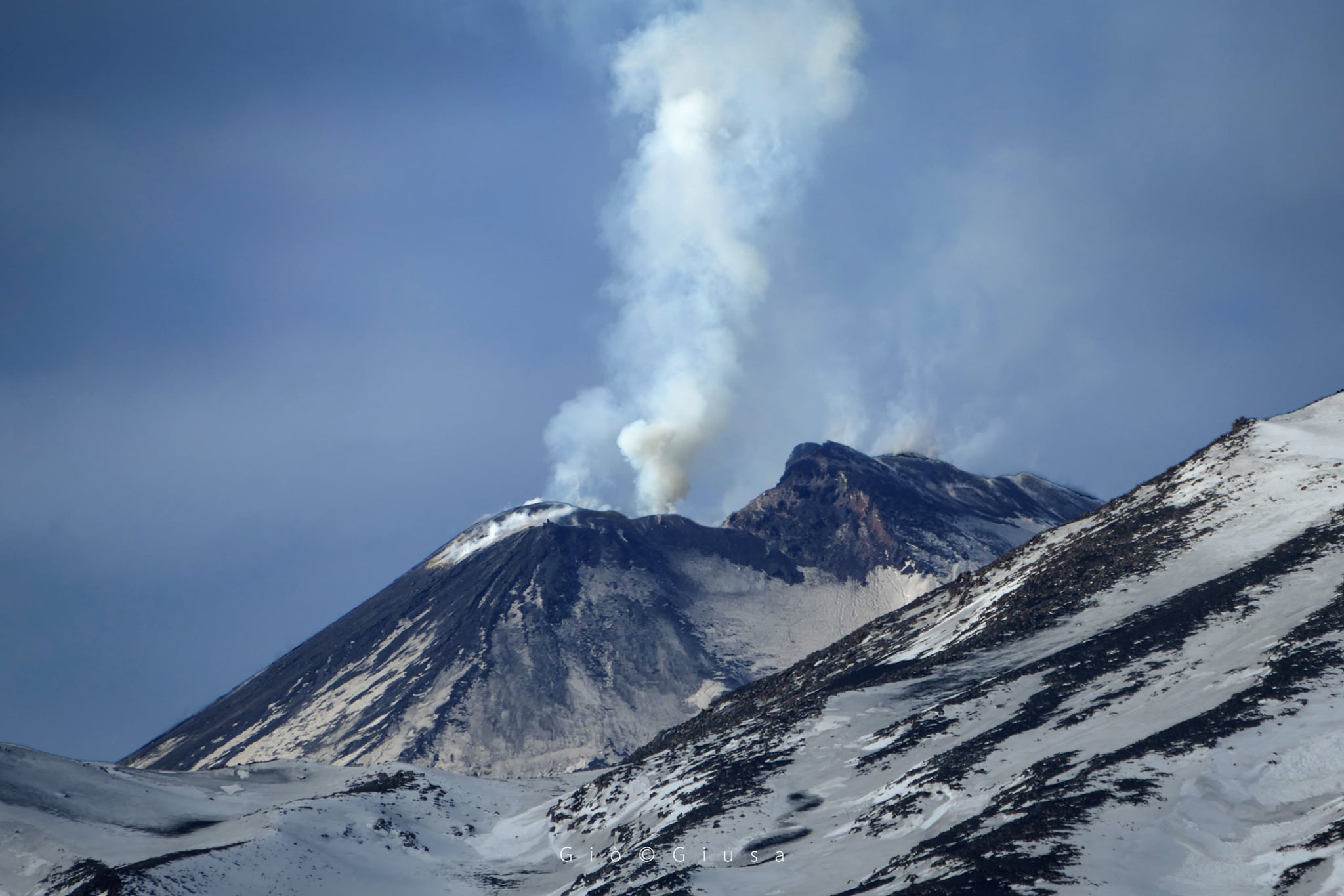
The National Institute of Geophysics and Volcanology, Osservatorio Etneo, reports that weak and intermittent Strombolian activity continues at the Southeast Crater which is periodically accompanied by emissions of light ash. Regarding the thermal anomaly observed in the area affected by the lava emission from the period of December 13 to 15 at the Southeast Crater and reported in update no. 99, we communicate that this is no longer obvious. However, due to adverse weather conditions, observations of eruptive activity are discontinuous.
From a seismic point of view, compared to the update no. 99, the volcanic tremor showed modest fluctuations in its amplitude, currently maintaining an average value. The position of the center of gravity of its sources is always located in the area of the south-eastern crater. Regarding infrasonic activity, there was no significant variation in the number and extent of infrasonic events; the sources are mainly located in the area of the Northeast Crater and to a lesser extent in the area of the Southeast Crater.
To complete the seismic picture, it should be noted that today there was a very low energy swarm consisting of 19 earthquakes with a magnitude greater than or equal to 1.0, whose maximum local magnitude was equal to 1, 4, located in the summit area at a hypocentral depth between 0 and 2 km below sea level.
Finally, with regard to the deformations, no significant variation is observed in the signals recorded by the permanent observation measurement systems (inclinometric networks and GPS)
Further updates will be communicated shortly.
Source : INGV .
Read the article: http://www.ct.ingv.it/Dati/informative/vulcanico/ComunicatoETNA20201219185454.pdf
Photo : Gio Giusa .
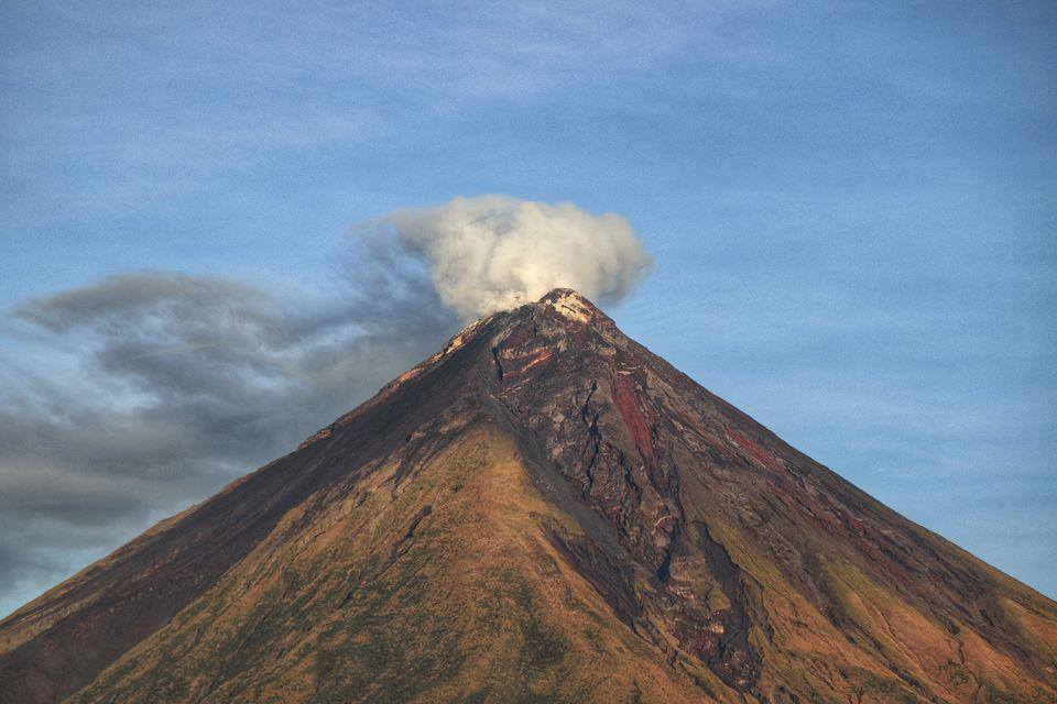
Philippines , Mayon :
MAYON VOLCANO BULLETIN 20 December 2020 08:00 A.M.
Mayon Volcano’s monitoring network recorded one (1) volcanic earthquake and six (6) rockfall events during the 24-hour observation period. Sulfur dioxide (SO2) emission was last measured below baseline average at 450 tonnes/day on 10 December 2020. Ground deformation data from Precise Leveling surveys on 28 November – 3 December 2020 indicated slight deflation of the edifice relative to the October 2020. Electronic tilt data also showed short-term deflation of the middle slopes since July 2020 after a period of non-steady inflation from late 2019 to mid-2020. Continuous GPS, however, recorded longer-term inflation of the lower to middle slopes since July 2019. Overall, the Mayon edifice is still inflated with respect to baseline parameters.
DOST-PHIVOLCS would like to remind the public that Mayon Volcano is at Alert Level 1, which means that it is at an abnormal condition. Although this means that presently no magmatic eruption is imminent, it is strongly advised that the public refrain from entering the 6-kilometer radius Permanent Danger Zone (PDZ) due to the perennial life-threatening dangers of rockfalls, landslides/avalanches at the middle to upper slope, sudden ash puffs and steam-driven or phreatic eruptions from the summit. Active stream/river channels and those identified as perennially lahar-prone areas on all sectors of the volcano should also be avoided especially during extreme weather conditions when there is heavy and prolonged rainfall.
DOST-PHIVOLCS maintains its close monitoring of Mayon Volcano and any new development will be communicated to all concerned stakeholders.
Source : Phivolcs
Photo : Erickson Banzuela Balderama
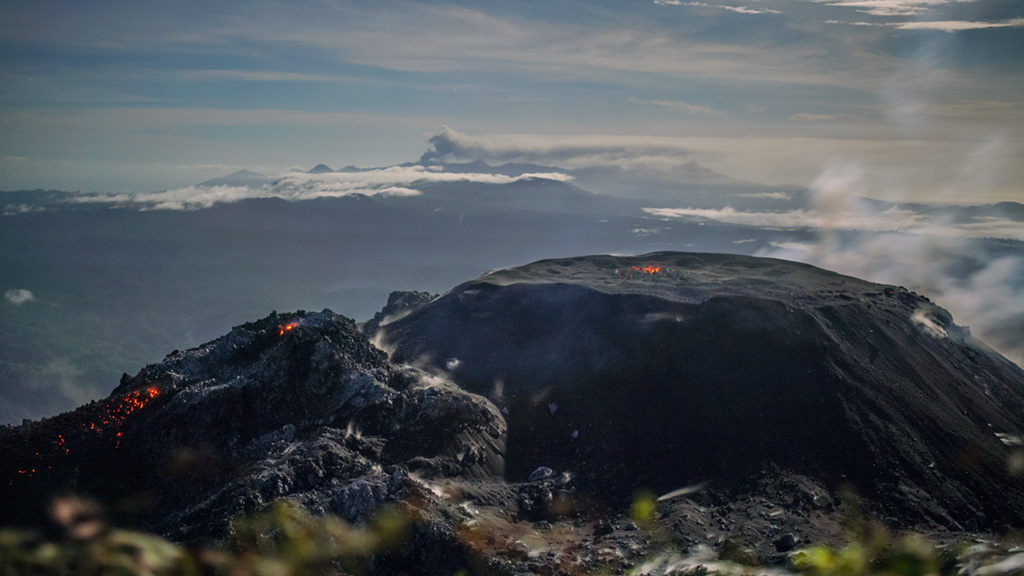
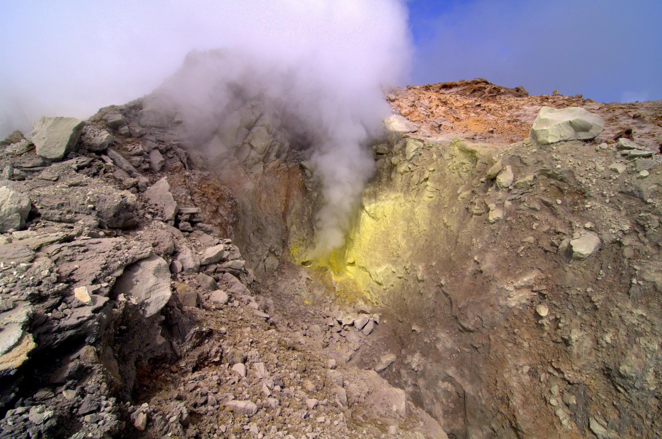
Indonesia , Ibu :
VOLCANO OBSERVATORY NOTICE FOR AVIATION – VONA.
Issued : December 20 , 2020
Volcano : Ibu (268030)
Current Aviation Colour Code : ORANGE
Previous Aviation Colour Code : orange
Source : Ibu Volcano Observatory
Notice Number : 2020IBU23
Volcano Location : N 01 deg 29 min 17 sec E 127 deg 37 min 48 sec
Area : North Maluku, Indonesia
Summit Elevation : 4240 FT (1325 M)
Volcanic Activity Summary :
Eruption with volcanic ash-cloud at 09h26 UTC (18h26 local)
Volcanic Cloud Height :
Best estimate of ash-cloud top is around 5520 FT (1725 M) above sea level, may be higher than what can be observed clearly. Source of height data: ground observer.
Other Volcanic Cloud Information :
White to grey ash-cloud moving to north
Remarks :
Eruption and ash emission is continuing
Level of activity level II (WASPADA). Mount Api Ibu (1340 m above sea level) has been erupting continuously since 2008. The eruption produced rocks the size of ash to boulders that accumulated in the crater.
The volcano was clearly visible until it was covered in fog. The crater emits white / gray smoke with low to medium intensity, about 200-800 meters above the summit. The weather is sunny to rainy, with weak to moderate winds in the north and east.
According to the seismographs of December 19, 2020, it was recorded:
● 92 earthquake eruptions / explosions
● 3 avalanche earthquakes
● 57 earthquakes of emissions
● 37 harmonic tremors
Source : Magma Indonésie , PVMBG.
Photo : Martin Rietze .
Guadeloupe Island , La Soufrière :
Sequence of earthquakes in the La Soufrière area of Guadeloupe – Basse Terre
The sequence of volcanic earthquakes that began Thursday, December 17, 2020 at 2:02 a.m. local time (6:02 a.m. UT *) in the area of the La Soufrière volcano continues.
Since the start of this sequence, the OVSG-IPGP networks have recorded 371 very low magnitude earthquakes (M <1).
No earthquakes were reported felt. The events are located at a depth of <2.5 km below the top of the dome of La Soufrière.
The alert level remains: yellow, vigilance.
Source : Direction de l’OVSG-IPGP
Photo : F. BEAUDUCEL/IPGP 2010.
Ecuador , Sangay :
SATURDAY DECEMBER 19, 2020
The Geophysical Institute of the National Polytechnic School reports that:
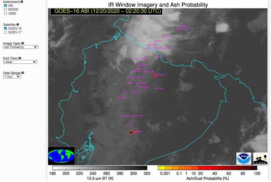
Tonight, the SAGA seismic station has been recording since 9:23 pm (TL) a signal linked to the emission of gas and / or ash. A GOES-16 satellite image shows a plume in a West-South-West direction towards Chimborazo province. This activity is similar to that recorded throughout the current eruptive period and could cause slight ash fall.
The Geophysical Institute of the National Polytechnic School is keeping an eye on the activity of the volcano and will report on any changes that may be recorded.
DAILY REPORT ON THE STATE OF SANGAY VOLCANO, Saturday December 19, 2020.
Surface activity level: High, Surface trend: Increasing.
Internal activity level: High, Internal trend: Increasing.
Seismicity: From December 18, 2020, 11:00 am to December 19, 2020, 11:00 am:
Long period type events (LP): 42
Emission tremor (TE): 5
Explosions (EXP): 70
Rains / lahars:
Rains were recorded in the area which did not generate lahars.
** In case of heavy rains, secondary lahars may be generated in the Volcán River, Upano and other tributaries **

Emission / ash column: On the images shared by the Volcanic Observers Network (Byron Rivadeneira, ROVE) an emission of gas and ash was observed in a southwest direction with a height greater than 1000 meters above the level from the crater. The Washington VAAC agency reported 4 emission alerts observed on satellite imagery, the heights of which were approximately 870 and 2,070 meters above crater level and with directions to the Northwest, West and the southwest.
Other monitoring parameters: FIRMS recorded 4 thermal alerts on the Sangay in the last 24 hours.
Observations: Most of the time, the area of the volcano remained cloudy, which is why there is no visual recording of the activity at the surface level.
Alert level: yellow.
Sources : INSTITUT GÉOPHYSIQUE / ÉCOLE NATIONALE DE POLYTECHNIQUE.
Photos : Image satellite GOES-16 , Yong Soo Seung ( 04/12)