June 04 , 2020.
Italy / Sicily , Etna :
Weekly bulletin from May 25, 2020 to May 31, 2020 (issue date June 02, 2020)
SUMMARY OF THE STATUS OF THE ACTIVITY
In light of the monitoring data, it is underlined:
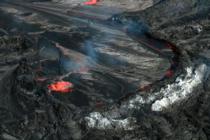
1) VOLCANOLOGICAL OBSERVATIONS: moderate intra-crater strombolian activity with occasional ash emissions from the New South-East Crater, and end of the explosive activity in the Voragine crater
2) SEISMOLOGY: Moderate seismicity of fractures. Amplitude of the tremor at high values.

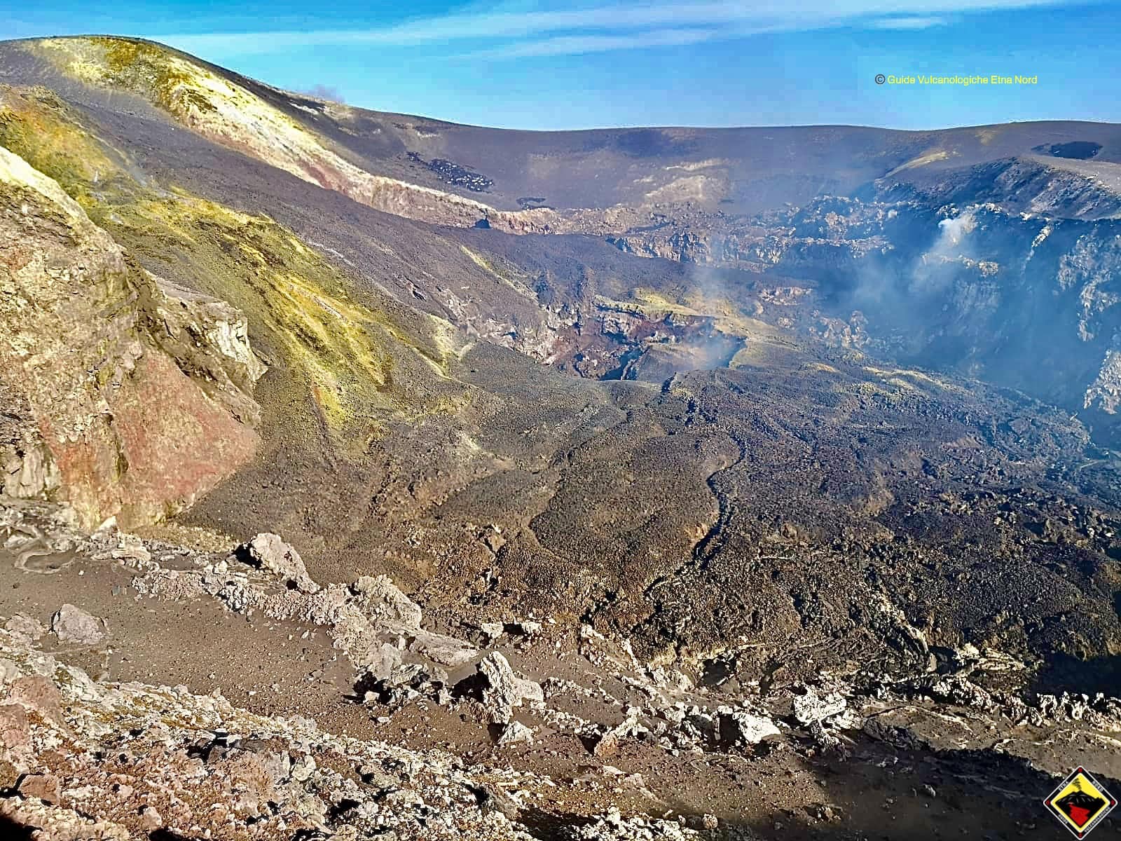
The inner mouth of the Northeast Crater, the summit of Mount Etna.
3) INFRASONS: Sustained activity.
4) DEFORMATIONS: The Etna soil deformation monitoring networks did not show any significant changes last week.
5) GEOCHEMISTRY: The flow of SO2 is at a medium-low level. Soil CO2 flow values are kept at average levels. The partial pressure of dissolved CO2 does not show significant variations. The C \ S ratio recorded discreetly (sampling carried out on May 28) at the Voragine crater is on average values. The isotopic ratio of helium is fixed at medium-high values (last update of 05/22).
6) SATELLITE OBSERVATIONS: The thermal activity in the summit area is low.
VOLCANOLOGICAL OBSERVATIONS
During the week, the volcanic activity of the summit craters of Etna was monitored by analyzing the images from the INGV surveillance cameras, Etneo Observatory (INGV-OE). Due to adverse weather conditions, continuity of observations was limited.
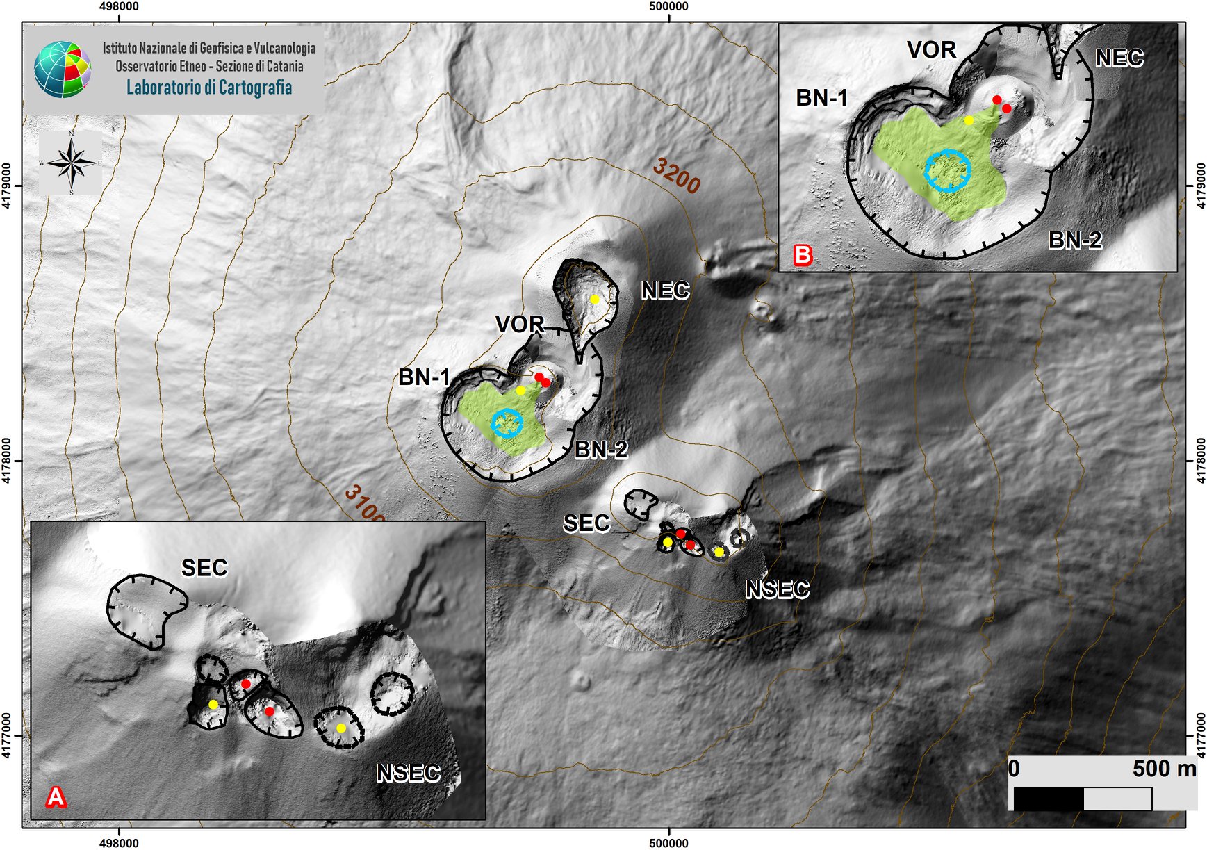
The area of the summit of Mount Etna with details on the volcanic complex of the southeastern crater / new southeastern crater (A), the Bocca Nuova and the Voragine (B).
During the period considered, the upper craters were characterized by a modest strombolian intra-crater activity with pulsed degassing in the New South-East crater (NSEC) and by degassing activities with variable regime in the crater of Voragine and at the northeast crater. In particular, with regard to the eruptive activity of the SEC / NSEC complex, during the week a persistence of visible flashes at night indicated a modest strombolian intra-crater activity. The images showed the absence of hot material falling on the surface and outside of the crater cone and the occasional emission of ash which quickly dispersed in the atmosphere.
With regard to the Voragina crater, during the week, image processing indicated the absence of strombolian explosive activity and therefore the probable end of the eruptive activity which started in September 2019. At l he current volcanic state of Voragine, like that of the North-East Crater, remains dominated by degassing activities.
Volcanic tremors:
During the week, the average amplitude of the volcanic tremor remained high. The sources of the tremor were located in the area of the New Southeast Crater, in a depth range between 2.5 and 3.0 km above sea level.
Source : INGV.
Read the whole article : file:///C:/Users/Utilisateur/AppData/Local/Packages/Microsoft.MicrosoftEdge_8wekyb3d8bbwe/TempState/Downloads/BollettinoEtna20200602%20(1).pdf
Photos : Gio Giusa , INGV , Guide Vulcanologiche Etna Nord .
El Salvador , San Miguel ( Chaparrastique) :
Location: San Miguel Department
Altitude: 2130 meters above sea level
Type of volcano: Stratovolcan
Activity type: Strombolienne-Vulcanienne
Last major eruption: December 29, 2013.
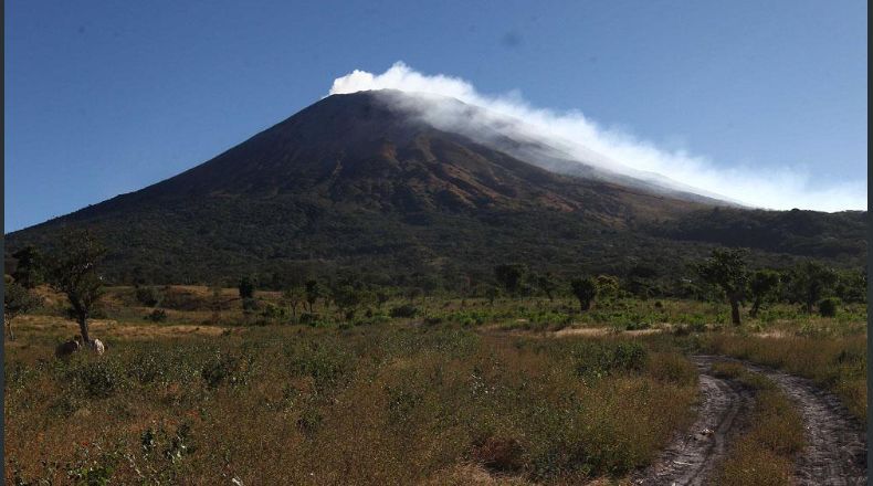
The most important activity of the San Miguel volcano took place in the afternoon of May 22, as it emitted a plume of white gases and vapors, rising about 150 m above the crater. Associated with this, a slight increase in the vibration of the volcano began, going from 40 to 110 RSAM units / hour on average. During the following days until the end of the month, the activity of the volcano remained in acceptable levels, without reaching the threshold of 150 units.
It is important to mention that due to tropical storm Amanda, at 7 a.m. from May 30 at 7 a.m. to June 1 at 7 a.m., the weather station of the San Miguel 2 volcano, at 1700 meters above sea level, located on the northern flank, reported precipitation of 416 mm.
Reports from the Local Observers Network indicate that the tanks are empty, which minimizes the problem of flooding in the lower area of the volcano.
As for sulfur dioxide (SO2) emissions, measured with DOAS equipment, they fluctuated between 141 and 600 tonnes per day, with an average of 335 tonnes per day, the threshold being 300 tonnes per day. Therefore, we can conclude that the volcano remains active but calm.
Source : Marn .
Photo : laprensagrafica.
Indonesia , Kawah Ijen :
8.058°S, 114.242°E
Elevation 2769 m
PVMBG reported that on 29 May a gas explosion at Ijen generated a plume that rose 250-500 m above the surface of the lake. According to news articles two sulfur miners heard the explosion from under the water at 1230, which created 3-m-high waves in the lake; the miners ran but one tripped and fell into the lake. Search efforts were unsuccessful after three hours and, due to weather conditions and an increased amount of gas in the crater area, had to be suspended.
PVMBG noted that patterns of various types of earthquakes did not indicate increased activity during 17 Janury-29 May. The temperature of the lake water fluctuated between 24.5 and 40.3 degrees Celsius. A lot of rain in the past few months increased the volume of the lake, possibly contributing to a disruption in the system, though these seasonal changes were within normal ranges at the volcano.
The Alert Level remained at 1 (on a scale of 1-4), and residents and visitors were advised to not approach the crater rim or descend to the crater floor.
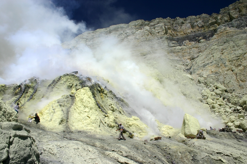
The Ijen volcano complex at the eastern end of Java consists of a group of small stratovolcanoes constructed within the large 20-km-wide Ijen (Kendeng) caldera. The north caldera wall forms a prominent arcuate ridge, but elsewhere the caldera rim is buried by post-caldera volcanoes, including Gunung Merapi, which forms the high point of the complex. Immediately west of the Gunung Merapi stratovolcano is the historically active Kawah Ijen crater, which contains a nearly 1-km-wide, turquoise-colored, acid lake. Picturesque Kawah Ijen is the world’s largest highly acidic lake and is the site of a labor-intensive sulfur mining operation in which sulfur-laden baskets are hand-carried from the crater floor. Many other post-caldera cones and craters are located within the caldera or along its rim. The largest concentration of cones forms an E-W zone across the southern side of the caldera. Coffee plantations cover much of the caldera floor, and tourists are drawn to its waterfalls, hot springs, and volcanic scenery.
Sources: PVMBG, Inibaru , GVP .
Photo : Blethrow / wikipedia .
Ecuador , Reventador :
0.077 ° S, 77.656 ° W
Altitude 3,562 m
DAILY REPORT OF THE STATE OF THE VOLCANO REVENTADOR, Wednesday 03 June 2020.
Information Geophysical Institute – EPN.
Surface activity level: High, Surface trend: No change.
Internal activity level: High, Internal trend: No change.
Seismicity: From June 02, 2020, 11:00 a.m. to June 03, 2020, 11:00 a.m.
Long Period Type (LP): 28 events
Explosions (EXP): 24 events
Emission tremors: (TE): 5.
Harmonic tremors: (TA): 5.
Rains / lahars: Not recorded.
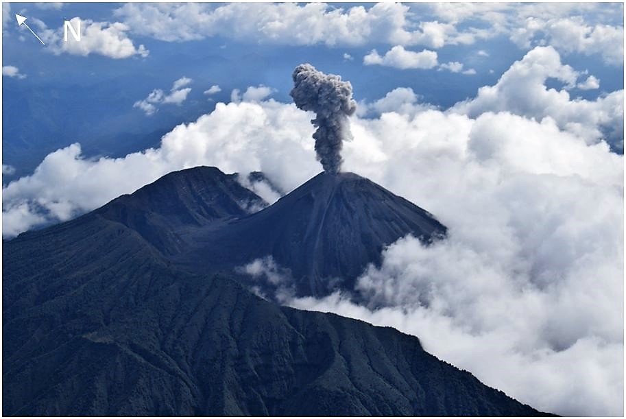
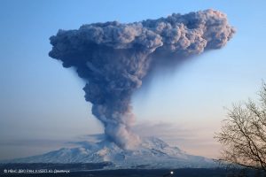
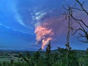
Emission / ash column: Various gas and ash emissions have been observed, reaching heights between 800 and 1000 meters above the crater level. The direction of the plume was stable towards the west.
Other monitoring parameters: no change.
Observations: During the last 24 hours, the volcano was cleared for several moments, which allowed to observe the emissions already described. An incandescence was observed at night in the crater.
Alert level: Orange.
IG reported that during 27 May-2 June seismic data from Reventador’s network indicated a high level of seismic activity, including explosions, long-period earthquakes, and signals indicating emissions. Gas, steam, and ash emissions observed daily with the webcam or reported by the Washington VAAC rose as high as 1.4 km above the summit crater and drifted N, NW, W, and SW. Cloudy weather sometimes prevented views of the volcano. Incandescent blocks rolled as far as 500 m down the S and E flanks during 27-28 May. Nighttime crater incandescence was visible during 27-28 and 30 May, as well as during 1-2 June.
Source: IIGEPN , GVP.
Photo : IGEPN.
Mexico , Popocatepetl :
June 03, 11:00 a.m. (June 03, 4:00 p.m. GMT)
In the past 24 hours, the Popocatépetl volcano monitoring system has identified 274 exhalations accompanied by volcanic gases and sometimes slight amounts of ash. In addition, 257 minutes of tremors were recorded.

Since the morning, the volcano has been observed with a continuous emission of water vapor, gas and ash in a southwest direction.
CENAPRED urges not to get near the volcano and especially the crater, because of the danger involved in the fall of ballistic fragments and, in the event of heavy rain, to move away from the bottom of the ravines because of the danger of mud and debris.
The Popocatépetl volcanic alert signaling light is in YELLOW PHASE 2.
Source : Cenapred .