April 05 , 2020 .
La Réunion , Piton de la Fournaise :
Activity bulletin from Saturday April 4, 2020 at 3.30 p.m. (local time)
Alert level: 2-2
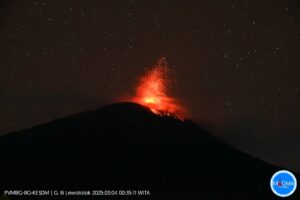
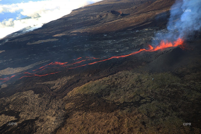
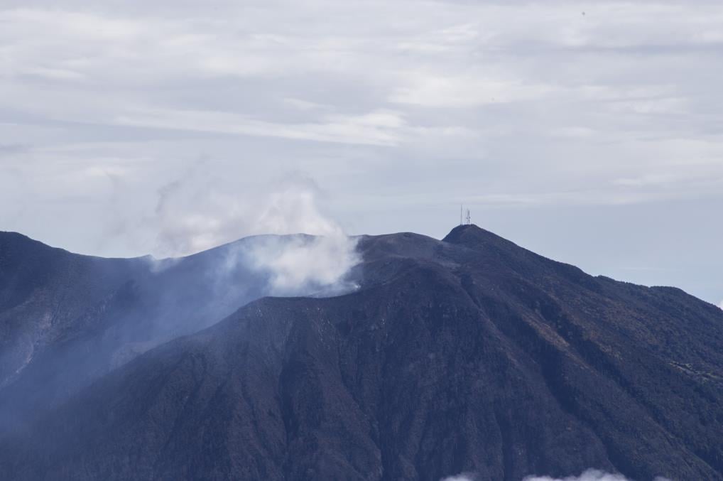
The eruption which started on 02/04/2020 on the eastern flank of Piton de la Fournaise, around 12:20 local time, continues. The intensity of the volcanic tremor (indicator of the intensity of the eruption) has been relatively stable over the past 24 hours despite a temporary increase between 9:00 a.m. and 11:00 a.m. (local time) this morning (Figure 1).
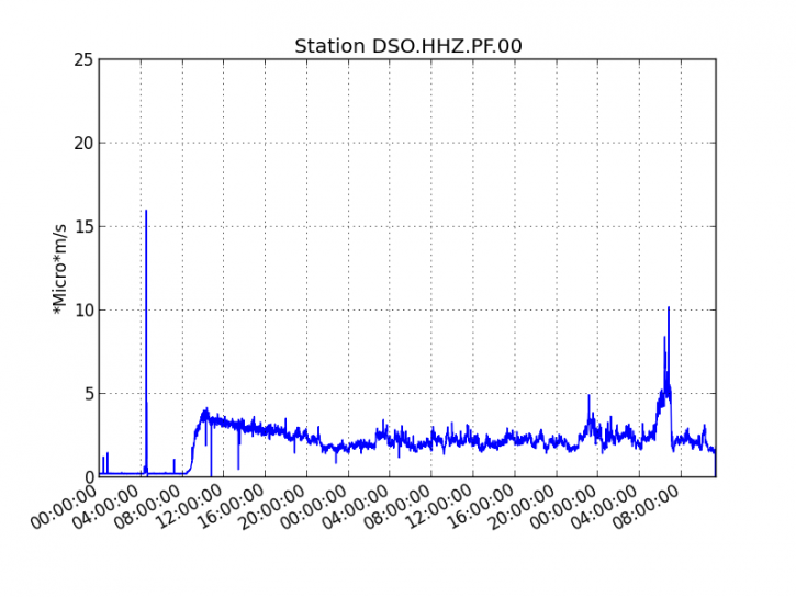
Figure 1: Evolution of the RSAM (indicator of the volcanic tremor and the intensity of the eruption) since 02/04/2020 00h UT time (04h local time) on the seismic station DSO located at the top of the volcano. (© OVPF / IPGP).
The bad weather prevailing in the eastern area of Piton de la Fournaise at the beginning of the morning did not allow us to locate the casting front using the images from our cameras.
Since yesterday morning 00:00 UTC (04:00 local time) no significant deformation has been recorded, and 5 superficial volcano-tectonic earthquakes have been recorded under the summit craters.
The estimated surface flows, based on satellite data via the HOTVOLC platform (OPGC – University of Auvergne) remain greatly disturbed by the cloud cover over the Piton de la Fournaise massif. The rare estimates made since yesterday evening fluctuate between 5 and 37 m3 / s with an average around 7-10 m3 / s.
Note that during this confinement period, all of the OVPF and IPGP teams remain mobilized to monitor this crisis remotely by telework and rely on a dense network of instrumentation (100 or so permanent sensors). installed on the volcano) whose data arrive in real time on the observatory’s servers.
Activity bulletin for Sunday April 5, 2020 (Local time)
Alert level: 2-2
The eruption which started on 02/04/2020 on the eastern flank of Piton de la Fournaise, around 12:20 local time, continues. The intensity of the volcanic tremor (indicator of the intensity of the eruption) has been relatively stable over the past 24 hours (Figure 1).
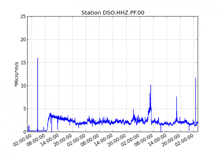
Figure 1: Evolution of the RSAM (indicator of the volcanic tremor and the intensity of the eruption) since 02/04/2020 00h UT time (04h local time) on the seismic station DSO located at the top of the volcano. (© OVPF / IPGP).
Over the past 24 hours:
– no significant deformation has been recorded,
– but a marked resumption of seismicity under the summit zone should be noted with 13 superficial volcano-tectonic earthquakes (<2 km deep) over the past 11 hours, including 10 over the past 5 hours.
Note that following this recovery in seismicity, the OVPF / IPGP lost data from one of its stations located near the eruptive crack (station became unreachable). A request for aerial reconnaissance via the Air Force Gendarmerie Section was requested in order to have a visual feedback of the situation at the eruptive site and to see if any new cracks would have opened.
– at the same time, the flow of CO2 into the soil at the distal stations (Plaine des Cafres, Plaine des Palmistes sector) is on the rise again. This increase could reflect the continuation of a deep recharge in magma.
An acquisition of the Sentinel1 satellite yesterday at the end of the afternoon (4/4/2020 at 18:52 local time) made it possible to carry out a mapping of the lava flow (Figure 2) as well as an interferogram in order to visualize the deformations at the scale of the of Enclos Fouqué (Figure 4).
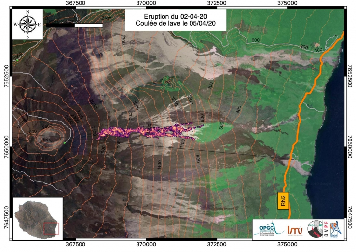
Figure 2: Mapping of the lava flow dated 4/4/2020 at 18:52 local time (© OVPF / IPGP / LMV / OPGV).
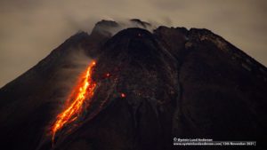
So yesterday, 4/4/2020 at 18:52 (local time), the casting front was around 800 m above sea level (against 1000 m above sea level on 03/04 morning), about 3.3 km (against 3.8 km on 03/04 morning) of the RN2. Given the slopes in the area, the flow front must have continued to spread overnight. Indeed, the shots taken last night by the Sainte Rose gendarmerie and the OVPF / IPGP webcam located in Piton Cascade (Sainte Rose) show that the flow continues to progress (Figure 3).
The aerial reconnaissance request will determine the new position of the flow front.
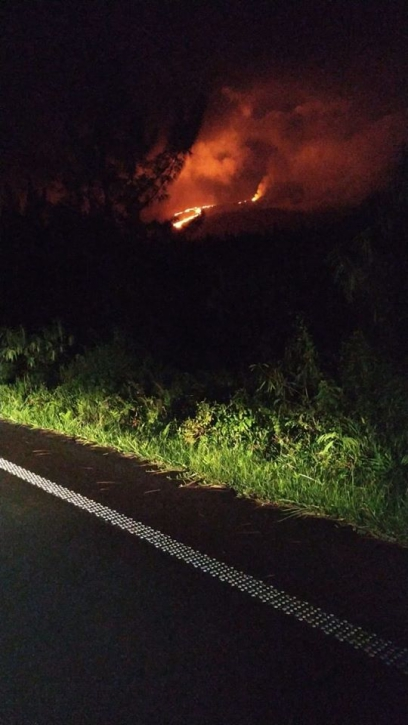
Figure 3: Shooting of the eruptive site from the RN2 by the Sainte Rose gendarmerie on 4/4/2020 around 8:30 p.m. local time.
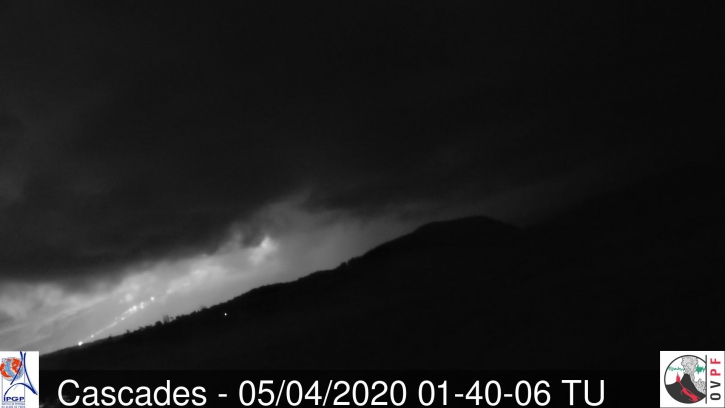
Figure 3: Shooting of the eruptive site from the webcam of the OVPF / IPGP located in Piton Cascades (Sainte Rose) on 5/4/2020 at 5:40 am local time (1:40 am UT on the left) (© OVPF / IPGP).
Note that the satellite data confirm that the deformations were very small during the lateral propagation of the magma towards the surface (less than 6 cm; Figure 4). This certainly confirms that the magma took a deep path already well open and extremely weakened (by the previous eruptions) before reaching the surface, as shown in particular by the location of the crack opened on April 2, in the continuity of those of the eruption of February 10-16, 2020 (Figure 4).
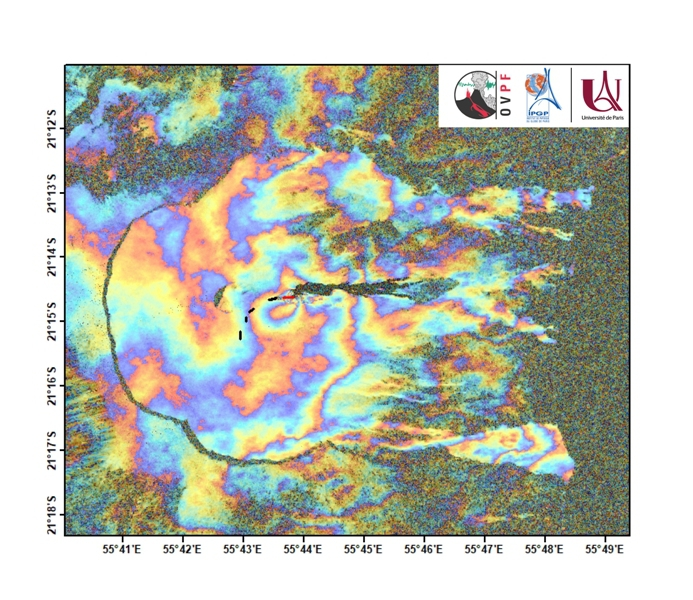
Figure 4: Interferogram representing the deformations at Piton de la Fournaise associated with the April 2, 2020 eruption (© OVPF-IPGP). In addition to ground measurements, the OVPF also uses a satellite technique called dInSAR to monitor the building’s inflation / deflation cycles associated with magma movements at depth. To do this, the satellite “illuminates” an area of the ground with an electromagnetic wave and collects the signal reflected from the ground. The comparison of two measurements of this type of the same surface taken at different times makes it possible to image the deformations of the surface. The interferogram above shows the deformation of the surface associated with the eruption of April 2, 2020. Each complete color cycle (from red to blue) of the interferogram corresponds to 27.8 mm of displacement from the surface to (positive) or opposite (negative) of the Sentinel-1 satellite (whose direction is represented by the arrow « LOS » at the top right of the figure). The black lines represent the location of the eruptive cracks of the eruption of February 10-16, 2020 and the red line the location of the crack opened on April 2, 2020 (© OVPF-IPGP).
he estimated surface flows, from satellite data via the HOTVOLC platform (OPGC – University of Auvergne) are still greatly disturbed by the cloud cover around the Piton de la Fournaise. But an increase seems to take shape over the last 12 hours with flows fluctuating between 3 and 63 m3 / s and an average around 15-25 m3 / s over the last 12 hours.
Note that during this confinement period, all of the OVPF and IPGP teams remain mobilized to monitor this crisis remotely by telework and rely on a dense network of instrumentation (100 or so permanent sensors). installed on the volcano) whose data arrive in real time on the observatory’s servers.
Source : OVPF.
Read the article : http://www.ipgp.fr/fr/ovpf/bulletin-dactivite-samedi-4-avril-2020-a-15h30-heure-locale
http://www.ipgp.fr/fr/ovpf/bulletin-dactivite-dimanche-5-avril-2020-heure-locale
Photos : IPR , OVPF.
Hawaii , Mauna Loa :
19°28’30 » N 155°36’29 » W,
Summit Elevation 13681 ft (4170 m)
Current Volcano Alert Level: ADVISORY
Current Aviation Color Code: YELLOW
Activity Summary:
Mauna Loa Volcano is not erupting. Rates of deformation and seismicity have not changed significantly over the past week and remain above long-term background levels.
Observations:
During the past week, HVO seismometers recorded 47 small-magnitude earthquakes on the volcano’s summit and upper-elevation flanks. Most of these earthquakes occurred at shallow depths of less than 8 kilometers (~5 miles) below ground level. The largest earthquake was a magnitude 2.1 on the volcano’s northwest flank.
Global Positioning System (GPS) measurements show continued slow summit inflation, consistent with magma supply to the volcano’s shallow storage system.
Gas concentrations at the Sulphur Cone monitoring site on the Southwest Rift Zone remain stable. Fumarole temperatures as measured at both Sulphur Cone and the summit have not changed significantly.
Source : HVO.
Iceland , Reykjanes Peninsula :
Seismic activity and deformation on Reykjanes Peninsula
Considerable seismic activity has been there recently due to uplift in the area. The most likely explanation of the uplift is that magma intrusions are intruding into the crust at depth. There are indications of three new magmatic intrusions on the Reykjanes peninsula, two below the area NW of Mt. Þorbjörn (3-4 km depth) and one below Sýrfell (8-13 km depth), further to the west on the peninsula.
Uncertainty phase that Civil Protections declared due to this activity is still in force.
Around 1200 earthquakes were located by IMO¿s SIL seismic network this week, fewer than the previous week when around 1500 earthquakes were located. The activity in Reykjanesskagi remains high after an earthquake swarm started there on 12. March. Around 800 earthquakes were located there this week, there of M3.3 on 25. March that was widely felt in Reykjanes and the Capital Region. Three other earthquakes smaller than M3.0 were felt in Grindavík as well. The largest earthquakes of the week were two M3.5 that occurred as part of a swarm on Reykjanes ridge, just north of Eldey on 28. March. Three other earthquakes larger than M3.0 were located in the swarm. An earthquake swarm started in Öxarfjörður around 8 km southwest of Kópasker on 27. March. The largest earthquake of the swarm was M3.1 and was felt in Kópasker. A total of seven earthquakes larger than M3.0 were located this week. One small earthquake was located in Hekla.
Source : IMO
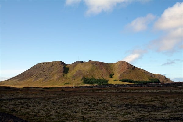
Photo : Visit Reykjanes.
Costa Rica , Turrialba / Poas / Rincon de la Vieja :
Volcanic Monitoring Program , Weekly Bulletin March 30, 2020
Turrialba volcano:
Lat: 10.025 ° N; Long: 83,767 ° W;
Height: 3340 m above sea level
Current activity level: 2 (active volcano)
Potentially associated hazards: gas, ash emission, proximal ballistic emissions.
No ash emission was detected. Seismicity has been stable for over a year. No VT type event has been recorded. Geodetic measurements indicate a tendency to horizontal contraction and a slight uplift of the massif (<1 cm from January). The summit continues to move towards the active crater. The CO 2 / SO 2 and H 2 S / SO 2 gas ratios have slightly higher values than a few weeks ago, but do not reach abnormal values. The flow of SO 2 remains stable and low (<300 t / d).
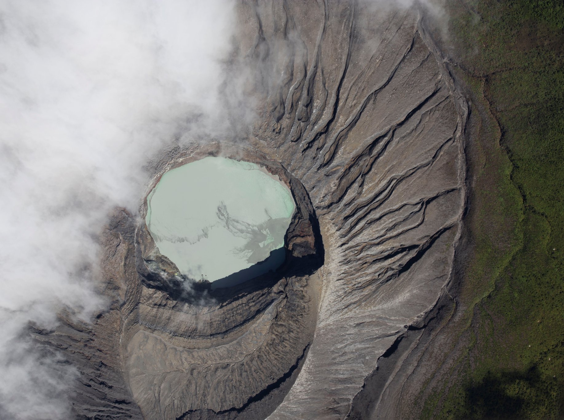
Poás Volcano.
Lat: 10.2 ° N; Long: 84 233 ° W;
Height: 2780 m above sea level
Current activity level: 3 (active volcano)
Potentially associated hazards: gas, ash emission, phreatic eruptions, proximal ballistic emissions.
https://www.facebook.com/OVSICORI/videos/2552402575086776/
Seismic activity shows an increase from March 28 to 29: the tremor is continuous, shows changes in frequency and an increase in intensity, the number of LP type events is close to 300 daily events. On March 23, a magnitude 2.2 VT event presented a normal focal failure mechanism 3 km deep. Geodetic observations detect a stabilization of the uprising which started in December (~ 1.5 cm). The SO 2 / CO 2 ratio has stabilized at a high value close to the critical value (~ 2.0), which suggests groundwater eruptions. The H 2 S / SO 2 ratio is kept very low with higher isolated measurements. The flow of SO 2 remains stable between 100 and 200 t / d. The level of the lake continues to drop, now rapidly. Since February 7, it has lost approximately 26,000 m 3 (33%).
Rincon de la Vieja volcano:
Lat: 10.83 ° N; Long: 85.324 ° W;
Height: 1895 m above sea level
Current activity level: 3 (erupting volcano)
Potentially associated hazards: gas, phreatic eruptions, proximal ballistic emissions, lahars.
2-3 small eruptions were detected daily most days of the week. Some were able to reach the edge of the crater but without generating lahars. The tremor is continuous until a small eruption occurs, then disappears for an indefinite interval. Few TV events and one « Tornillo » event were recorded. Geodetic observations detect a slight inflation of the building with an elevation which reaches ~ 1.5 cm since the beginning of February. The redox potential of a hot spring in the northern zone has stabilized.
At 08:24:00 local time on April 04, 2020, an eruption was recorded on the Rincon de la Vieja volcano, with a column that rises 1000 meters above the crater height and 2916 meters above above sea level. (9564.48 ft).
Source : Ovsicori .
Photos : RSN.
Video : Ovsicori.