February 07 , 2020 .
Hawaii , Kilauea :
19°25’16 » N 155°17’13 » W,
Summit Elevation 4091 ft (1247 m)
Current Volcano Alert Level: NORMAL
Current Aviation Color Code: GREEN
Activity Summary:
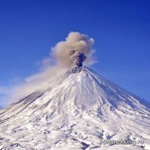
Kīlauea Volcano is not erupting. Monitoring data for January show variable rates of seismicity and ground deformation, low rates of sulfur dioxide emissions, and only minor geologic changes since the end of eruptive activity in September 2018.
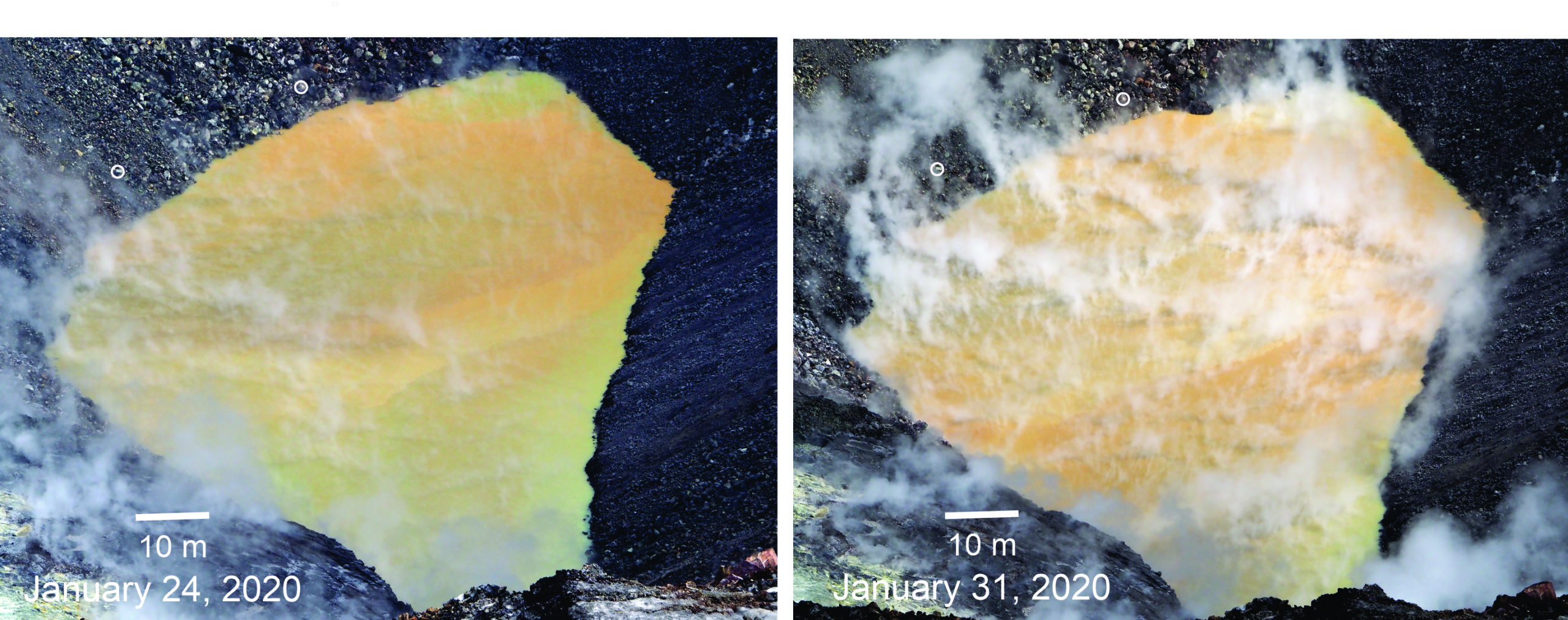
Field observations today show that the diameters of the crater lake within Halema‘uma‘u at the summit of Kīlauea are about 94 m (308 ft) north-south and around 192-195 m (630-640 ft) east-west. Too much steam at the west end interfered with measurements this morning. Two small circles above the northeast edge of the water show how much the lake has grown since January 24. USGS photos by D. Swanson.
Observations:
Monitoring data have shown no significant changes in volcanic activity during January.
Rates of seismicity over the month were variable but within long term vales. Sulfur dioxide emission rates are low at the summit and are below detection limits at Puʻu ʻŌʻō and the lower East Rift Zone. The pond at the bottom of Halema’uma’u, which began forming on July 25, 2019, continues to slowly expand and deepen. As of early February, dimensions are: 95 meters by 194 meters or approximately 310 feet by 640 feet. Current depth is approximately 25 meters or 82 feet.
Over the past month, eight deflation-inflation (DI) events occurred beneath the summit, slightly less than the prior month. Since early March 2019, GPS stations and tiltmeters at the Kīlauea summit have recorded deformation consistent with slow magma accumulation within the shallow portion of the Kīlauea summit magma system (1-2 km or approximately 1 mile below ground level). During January, deformation rates at Kilauea summit appeared to have decreased somewhat. Gas measurements show continuing low levels of sulfur dioxide, consistent with no significant shallowing of magma. Some amount of sulfur dioxide is being dissolved into the summit lake; work continues to try and quantify this process.
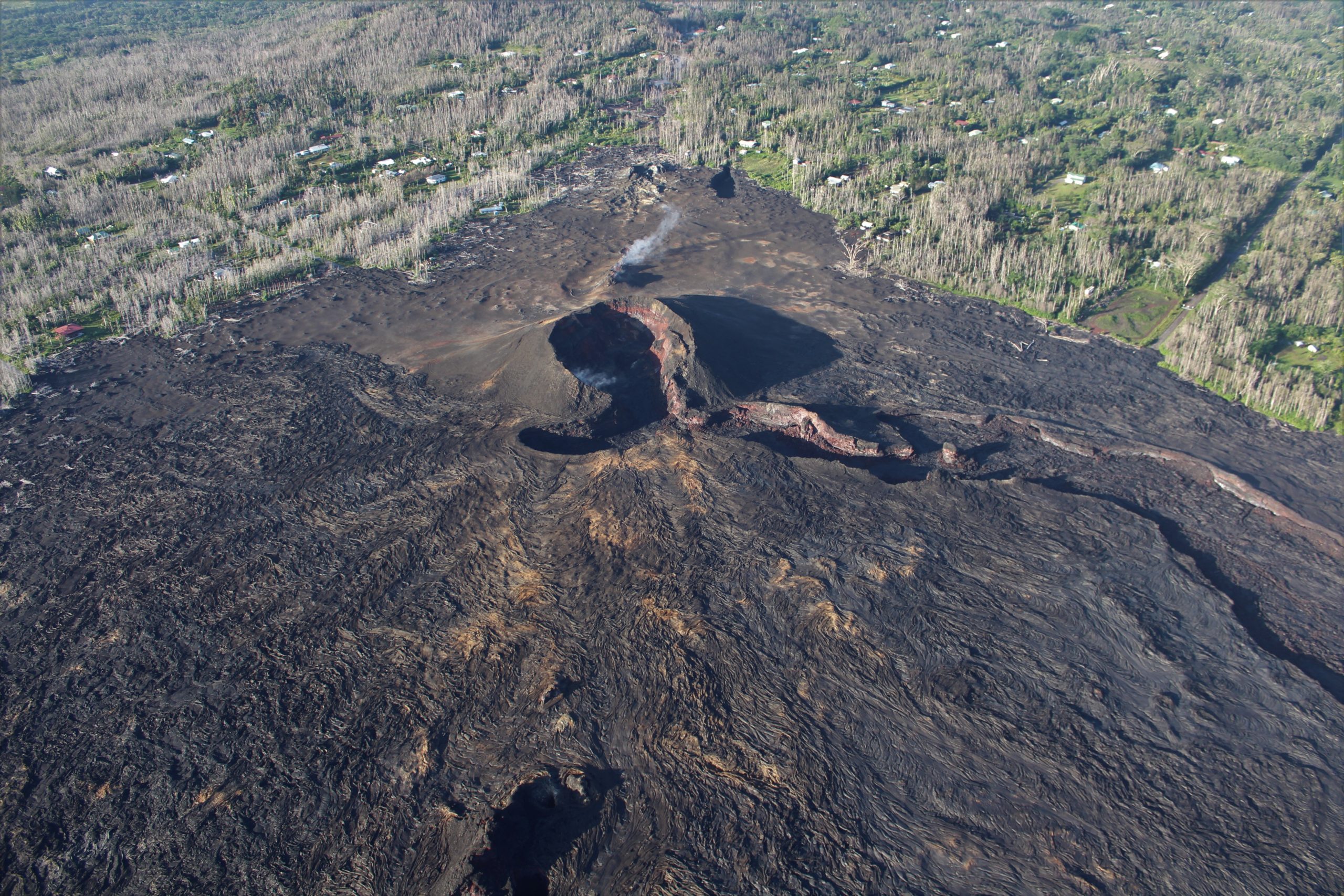
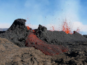
HVO geologists conducted a routine helicopter overflight of Kīlauea’s East Rift Zone, from Pu‘u ‘Ō‘ō to the lower East Rift Zone flow field, on Tuesday, January 21. This photo looks uprift (west) and shows Fissure 8, the dominant vent for the 2018 lower East Rift Zone eruption. Minor steaming is normally present in and around the cone. USGS photo by M. Zoeller.
Farther east, GPS stations and tiltmeters continue to show motions consistent with slowed refilling of the deep East Rift Zone magmatic reservoir in the broad region between Puʻu ʻŌʻō and Highway 130. During January, deformation rates in this region appeared to have decreased somewhat. Monitoring data do not suggest any imminent change in volcanic hazard for this area. In addition to motion along the East Rift Zone, the south flank of Kīlauea continues to creep seaward at elevated rates following the May 4, 2018 M6.9 earthquake near Kalapana. HVO continues to carefully monitor all data streams along the Kīlauea East Rift Zone and south flank for important changes.
Although not currently erupting, areas of persistently elevated ground temperatures and minor release of gases are still found in the vicinity of the 2018 lower East Rift Zone fissures. These include steam (water), very small amounts of hydrogen sulfide, and carbon dioxide. These conditions are expected to be long-term. Similar conditions following the 1955 eruption continued for years to decades.
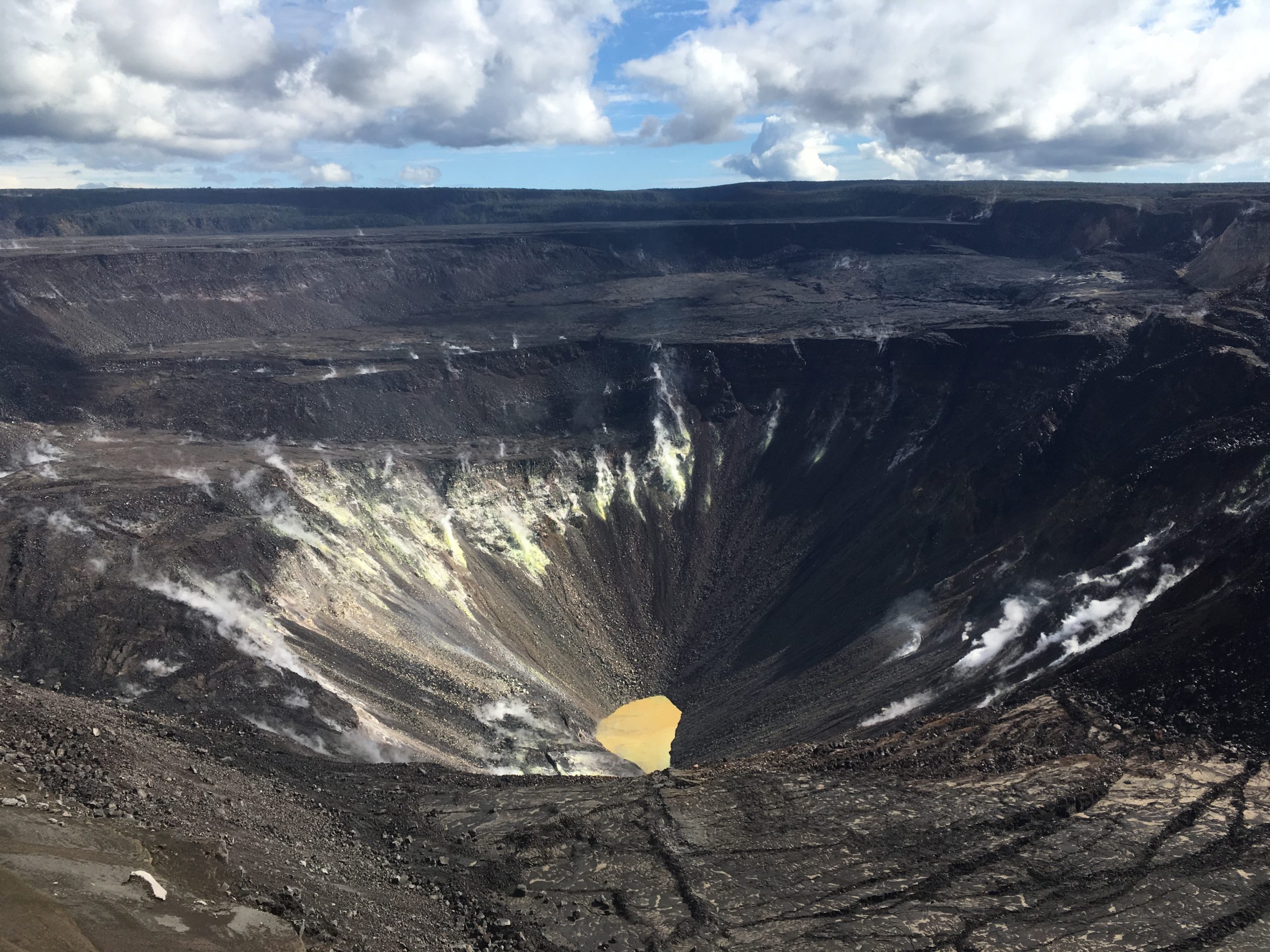
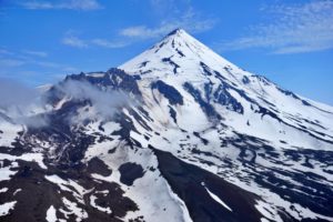
After days of rain, a window of clear weather allowed HVO geologists to make observations and take measurements of the water pond at Kīlauea’s summit. No major changes were observed, and the water level continues to slowly rise. USGS photo by M. Patrick.
Hazards:
Hazards remain in the lower East Rift Zone eruption area and at the Kīlauea summit. Residents and visitors near the 2018 fissures, lava flows, and summit collapse area should heed Hawaii County Civil Defense and National Park warnings. Lava flows and features created by the 2018 eruption are primarily on private property and persons are asked to be respectful and not enter or park on private property.
Source et photos : HVO.
Alaska , Shishaldin :
AVO/USGS Volcanic Activity Notice
Current Volcano Alert Level: ADVISORY
Previous Volcano Alert Level: WATCH
Current Aviation Color Code: YELLOW
Previous Aviation Color Code: ORANGE
Issued: Thursday, February 6, 2020, 4:20 PM AKST
Source: Alaska Volcano Observatory
Location: N 54 deg 45 min W 163 deg 58 min
Elevation: 9373 ft (2857 m)
Area: Aleutians
Volcanic Activity Summary:
Seismicity at Shishaldin Volcano has decreased over the past week to levels slightly above background. In addition, satellite views of the volcano over the same period show a decrease in surface temperatures at the summit. Eruptive activity appears to have ended or paused. Due to this decrease in activity, the Alaska Volcano Observatory is decreasing the Aviation Color Code for Shishaldin Volcano to YELLOW and the Alert Level to ADVISORY.
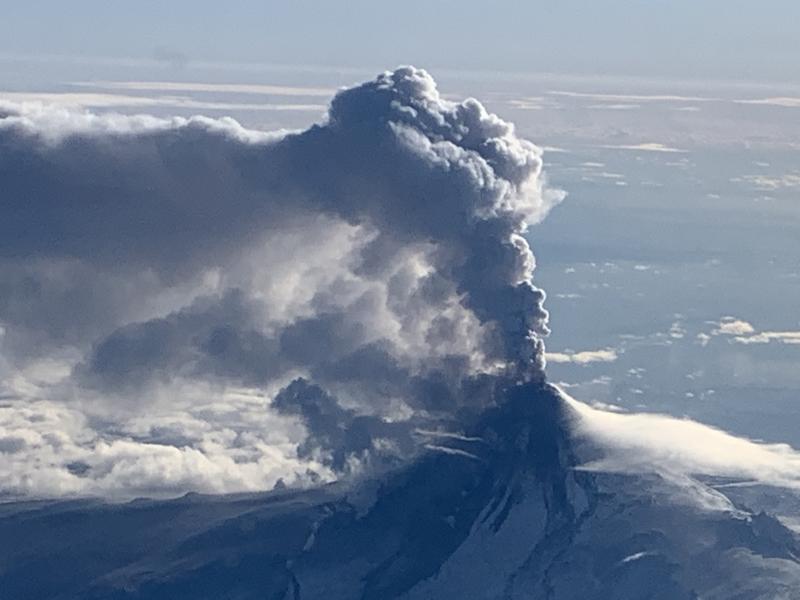
Shishaldin volcano in eruption, January 19, 2020.
It is possible for eruptive activity to resume with little warning and AVO will continue to monitor the volcano closely.
Shishaldin is monitored by local seismic and infrasound sensors, satellite data, a web camera, a telemetered geodetic network, and distant infrasound and lightning networks.
Recent Observations:
[Volcanic cloud height] na
[Other volcanic cloud information] na
Remarks:
Shishaldin volcano, located near the center of Unimak Island in the eastern Aleutian Islands, is a spectacular symmetric cone with a base diameter of approximately 16 km (10 mi). A 200-m-wide (660 ft) funnel-shaped summit crater typically emits a steam plume and occasional small amounts of ash. Shishaldin is one of the most active volcanoes in the Aleutian volcanic arc, with at least 54 episodes of unrest including over 24 confirmed eruptions since 1775. Most eruptions are relatively small, although the April-May 1999 event generated an ash column that reached 45,000 ft above sea level.
Source : AVO Alaska .
Photo : Woodsen Saunders / AVO .
Philippines , Taal / Mayon :
TAAL VOLCANO BULLETIN 07 February 2020 8:00 A.M.
Activity in the Main Crater in the past 24 hours has been characterized by moderate emission of white to dirty white steam-laden plumes rising 200 to 300m high before drifting southwest. Weak steaming from fissure vents along the Daang Kastila trail is currently ongoing. Sulfur dioxide (SO2) emission was again below instrumental detection due to weak plume activity. The Taal Volcano Network recorded one hundred eighteen (118) volcanic earthquakes including five (5) low-frequency events and one (1) harmonic tremor that lasted less than three (3) minutes. These earthquakes signify magmatic activity beneath the Taal edifice that could lead to eruptive activity at the Main Crater.
https://www.facebook.com/raffytima/videos/10157284275802758/
MAYON VOLCANO BULLETIN , 07 February 2020 , 8:00 A.M.
Mayon Volcano’s seismic monitoring network did not detect any volcanic earthquake during the 24-hour observation period. Sulfur dioxide (SO2) emission was measured at an average of 115 tonnes/day on 10 January 2020. Ground deformation data from Precise Leveling surveys obtained on 23 – 30 October 2019 indicate a slight deflation of the edifice relative to 16 – 25 July 2019. However, the volcano generally remains inflated relative to the early 2019 baseline level. This is consistent with recent electronic tilt data. Continuous GPS data also showed inflation of the edifice since February 2019.
Source : Phivolcs .
Vidéo : Raffy Tima .
Guatemala , Santiaguito :
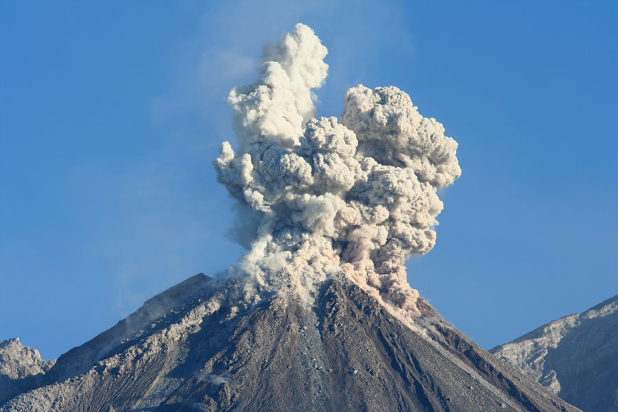
Activity type: Pelean
Morphology: Complex of dacitic domes
Location: 14 ° 44 ’33 ˝ Latitude N; 91 ° 34’13˝ Longitude W.
Height: 2500 m
Atmospheric conditions : Cloudy
Wind: Southwest
Precipitation: 0.0 mm.
Activity:
Presence of a white degassing which culminates at 3000 meters above sea level (9842 feet) and disperses towards the East. The STG3 seismic station records low to moderate explosions expelling columns of ash at a height of approximately 3400 meters (11154 feet) which move north, north-east and east. There is an incandescence in the crater of the Caliente dome at night. Weak / moderate / strong avalanches on the south-eastern flank from the Caliente dome generate ash clouds during their descent.
Source : Insivumeh .
Photo : Auteur inconnu.