November 08 , 2019 .
Hawaii , Kilauea :
19°25’16 » N 155°17’13 » W,
Summit Elevation 4091 ft (1247 m)
Current Volcano Alert Level: NORMAL
Current Aviation Color Code: GREEN
Activity Summary:
Kīlauea Volcano is not erupting. Monitoring data continue to show steady rates of seismicity and ground deformation, low rates of sulfur dioxide emissions, and only minor geologic changes since the end of eruptive activity in September 2018.
Observations:
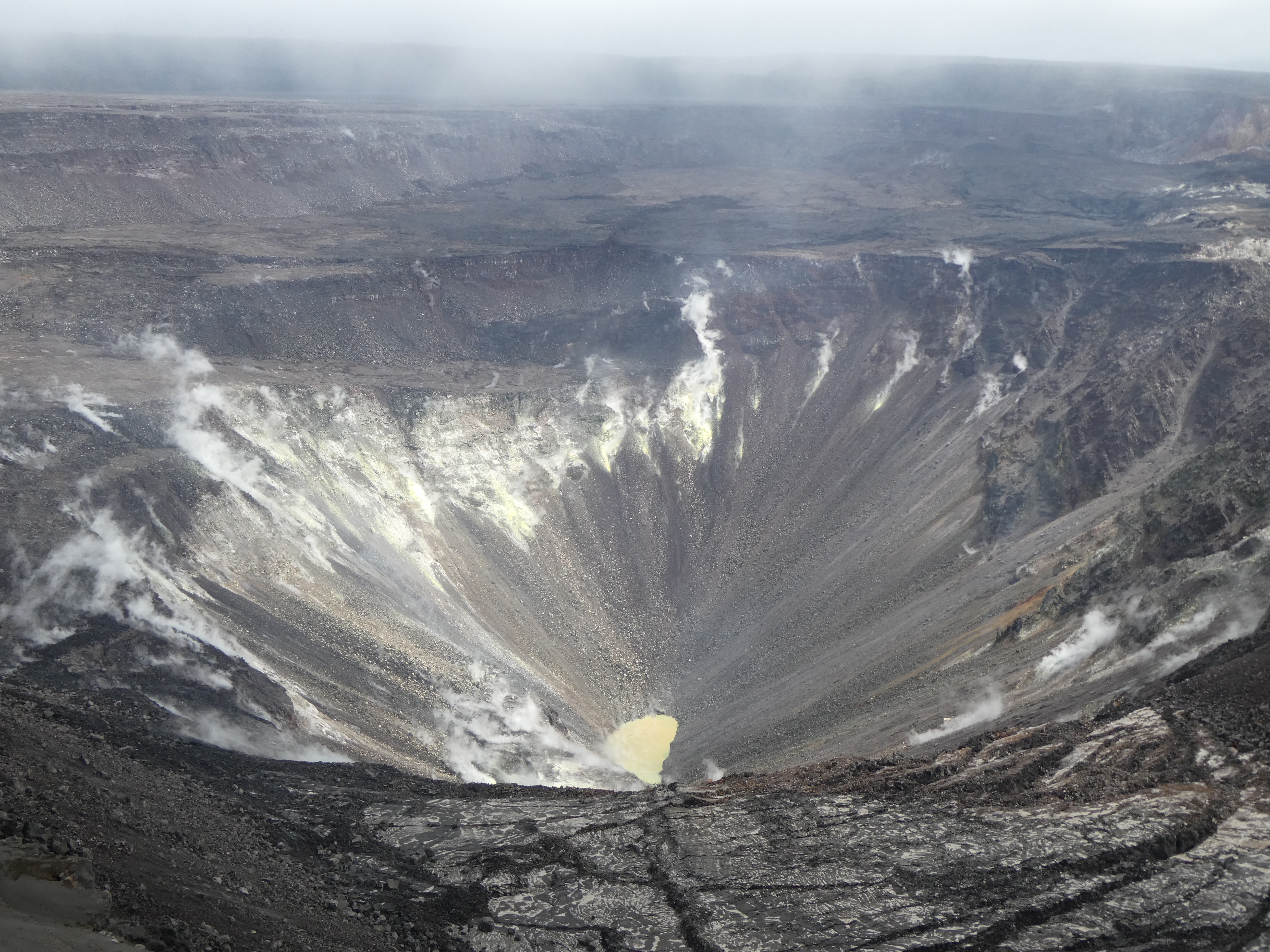
Monitoring data have shown no significant changes in volcanic activity during September. Seismic stations detected over 1600 events, which is an increase of ~12% from last month. Episodic increases in seismicity seem to have lost their timely periodicity, as the last swarm (Oct 13) was followed by low rates of seismicity at the summit. Sulfur dioxide emission rates are low at the summit and are below detection limits at Puʻu ʻŌʻō and the lower East Rift Zone. The pond at the bottom of Halema’uma’u, which began forming on July 25, 2019, continues to slowly expand and deepen. See below for information on recent sample acquisition.
Although not currently erupting, areas of persistently elevated ground temperatures and minor release of gases are still found in the vicinity of the 2018 lower East Rift Zone fissures. These include steam (water), very small amounts of hydrogen sulfide, and carbon dioxide. These conditions are expected to be long-term. Similar conditions following the 1955 eruption continued for years to decades.
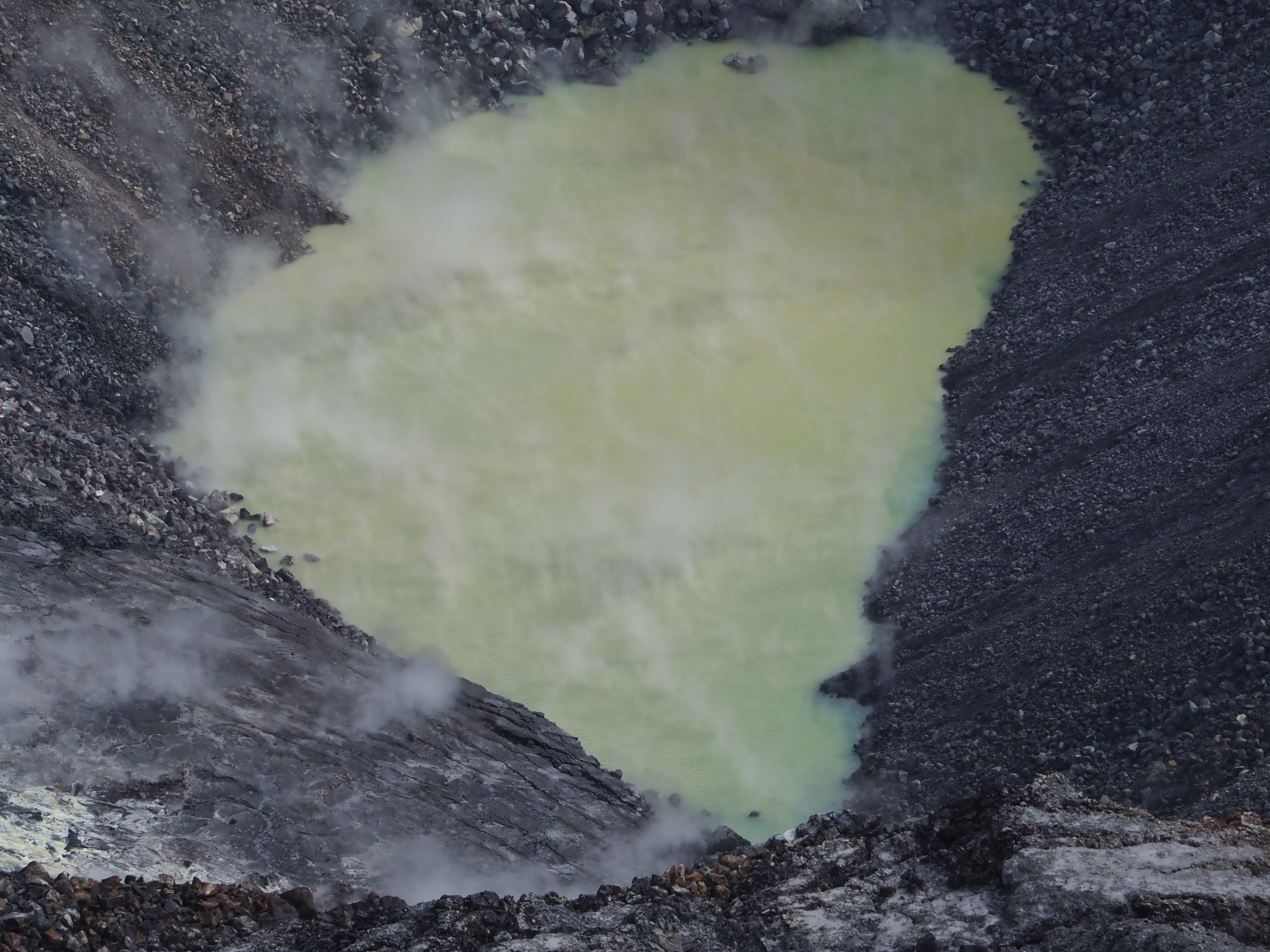
The water level at Kīlauea summit continues to slowly rise, with the size of the pond gradually enlarging. The pond today was at least 140 m (460 ft) in the east-west direction (from bottom to top of image). This length is a minimum estimate as the west end of the pond is now partially blocked from view by the crater walls. USGS photo by D. Swanson.
Since early March 2019, GPS stations and tiltmeters at the Kīlauea summit have recorded deformation consistent with slow magma accumulation within the shallow portion of the Kīlauea summit magma system (1-2 km or approximately 1 mile below ground level). However, gas measurements have yet to indicate significant shallowing of magma. HVO continues to carefully monitor all data streams at the Kīlauea summit for important changes.
There was an inflationary event near Pu’u O’o that occurred during the end of September through the first week of October. Continuous stations near the cone, like OKIT, NPOC and KAMO along with KALR, a campaign station experienced an acceleration of motion consistent with source inflation on the rift between Puʻu ʻŌʻō and Kupaianaha
Farther east, GPS stations and tiltmeters continue to show motions consistent with slowed refilling of the deep East Rift Zone magmatic reservoir in the broad region between Puʻu ʻŌʻō and Highway 130. Monitoring data do not suggest any imminent change in volcanic hazard for this area. In addition to motion along the East Rift Zone, the south flank of Kīlauea continues to creep seaward at elevated rates following the May 4, 2018 M6.9 earthquake near Kalapana. HVO continues to carefully monitor all data streams along the Kīlauea East Rift Zone and south flank for important changes.
A sample of the water collected from the Halema’uma’u water lake by UAS on October 26, 2019 has undergone preliminary analysis. Early results indicate that the sample has a pH of 4.2 (moderately acidic, in the range of many fruit juices) and high concentrations of dissolved sulfur and magnesium. This composition reflects complex processes including reactions between magmatic gases, groundwater (that was recharged as precipitation), and Kilauea’s basaltic rocks (through which the groundwater flows towards the pond). The water’s composition is significantly different from rainwater and is also significantly different from water present in the deep Keller Well 1.5 km (1 mi) south of Halema’uma’u. The difference from Keller Well water suggests that the release of magmatic gases is currently focused under the crater and ponded water, consistent with long term observations at the summit.
Results of the water sample analysis will assist HVO in evaluating potential eruptive hazards posed by Kilauea. For example, the high concentration of dissolved sulfate in the lake water (53,000 mg per liter, 75% of total dissolved solids) suggests that it originates from SO2 released by magma residing at shallow depths below Halema’uma’u. Further work may help constrain that depth.
If much of the SO2 emitted by subsurface magma is being dissolved into the water, current measurements of SO2 emission rate for Kīlauea summit (~30 t/d) are underestimates for true SO2 release from the magma. In the absence of the summit water, SO2 emission rates would likely be higher, perhaps closer to the ~200 t/d emitted prior to the 2008 appearance of the summit lava lake. Future changes in sulfate concentration of the water may indicate changes in SO2 degassing and magma depth.
The lake is also variable in color and temperature. HVO’s single sample of water may not be representative of the lake as a whole. Additional water samples may be necessary to best monitor all aspects of Kīlauea’s current non-eruptive state.
Source : HVO
Italy , Vesuvius :
During the month of October 2019, the activity of Vesuvius remained weak. 118 earthquakes were recorded (maximum magnitude = 1.8). Of these, 102 events (86.45% of the total) had a magnitude less than 1.0 and 13 events, a magnitude greater than or equal to 1.0. Of these, only 5 events were characterized by a magnitude greater than or equal to 1.5, which corresponds to a very low seismic activity.

Overall, in October, it was possible to locate 100 earthquakes, located mainly in the crater zone with depths not exceeding 2.5 km. Geodetic monitoring network data do not show deformations due to volcanic sources, but only gravitational effects, incoherent surface material compaction processes, or local effects that may influence soil slope. Thermographic measurements made in the crater area show a stationary tendency of the maximum temperature. Geochemical analyzes carried out on the rim and at the bottom of the crater do not show any significant variations.
Source : www.ov.ingv.it
Photo : Wikipédia .
Monthly Bulletin : http://www.ov.ingv.it/ov/bollettini-mensili-campania/Bollettino_Mensile_Vesuvio_2019_10.pdf
Costa Rica , Poas :
10.197 ° N – 84.702 ° W
Altitude of the active crater: 2550 m.s..m.
The lake stayed and grew during this week. The evaporation processes were less intense and the precipitation constant. The field of fumaroles rich in sulfur in the North-East sector maintains its activity of expiration. Seismically, the background tremor of low amplitude (2 to 4.5 Hz) was maintained, as well as discrete events of type LP (long period) of low amplitude.
https://www.facebook.com/RSN.CR/videos/658493304678615/
Visitors to the Poás Volcano National Park are reminded that this site has protocols for eruptions. Depending on the type of activity, visits may be suspended or delayed. In terms of the main crater, there are four shelters to protect themselves in case of eruption. Tourists are advised to always pay attention to any change of activity and to follow the instructions of the park wardens. It is recommended to stay away from the canals of rivers near the volcano in case of rain, as secondary lahars could be generated by ashes and material accumulated in the upper parts of the volcano by eruptions from previous years and weeks .
Source : RSN
Vidéo : Dr Paulo Ruiz / RSN
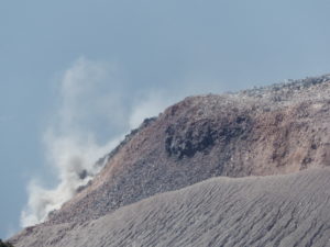
Chile , Nevados of Chillan :
Special Volcanic Activity Report (REAV) Ñuble Region, Nevados de Chillán Volcanic Complex November 6, 2019, 17:15 local time (mainland Chile).
The National Geological and Mining Service of Chile (Sernageomin) discloses the following PRELIMINARY information obtained from the monitoring equipment of the National Volcanic Monitoring Network (NVRN) processed and analyzed at the Volcanological Observatory of the Southern Andes ( OVDAS)
On Wednesday, November 6, at 16:41 local time (19:41 UTC), monitoring stations near the Nevados Volcanic Complex in Chillán recorded an explosion associated with an LP-type seismic signal.

The characteristics of the LP earthquake are as follows:
TIME OF ORIGIN: 16:41 local time (19:41 UTC)
LATITUDE: 36,869 ° S
LONGITUDE: 71.383 ° W
DEPTH: 0.45 km
REDUCED TRAVEL: 538 cm2
ACOUSTIC SIGNAL: 1.3 Pascals (Pa) reduced to 1 km
OBSERVATIONS:
The gas column associated with the explosion was approximately 610 m high.
The volcanic technical alert is maintained at the level: Orange.
Source : Sernageomin .
Photo : Publimetro