October 23 , 2019.
Peru , Sabancaya :
Period of analysis: 14-20 October 2019. Arequipa, October 21, 2019.
Alert level: ORANGE
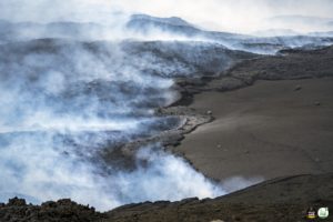
The Geophysical Institute of Peru (IGP) reports that the eruptive activity of the Sabancaya volcano has remained at moderate levels; that is, with the recording of continuous moderate explosions and the resulting ash emission. Therefore, for the following days, no significant change is expected.

Analysis of records obtained from the seismic network of the Sabancaya volcano for the period from 14 to 20 October 2019 identified the occurrence of 2084 earthquakes of volcanic origin, the highest percentage of which is associated with movements of magmatic fluids. During this week, an average of 44 explosions per day of mild to moderate intensity were observed.
The monitoring of the deformation of the volcanic structure, using GNSS data (processed with fast orbits), presents no significant anomalies. Visual surveillance, using surveillance cameras, identified the appearance of columns of gas and ash up to 2.5 km high above the summit of the volcano, which dispersed in the southern sectors. and Southeast of Sabancaya. Satellite monitoring has identified 15 volcanic anomalies on the volcano, ranging from 1 MW to 53 MW, associated with the presence of a hot body inside the volcano’s crater.
Source : IGP Pérou .
Photo : IGP.
Colombia , Chiles / Cerro Negro :
Weekly activity bulletin of Chiles and Cerro Negro volcanoes
The level of activity of volcanoes continues as at level: YELLOW LEVEL ■ (III): CHANGES IN THE BEHAVIOR OF VOLCANIC ACTIVITY.
Following the activity of VOLCANS CHILES AND CERRO NEGRO, the COLOMBIAN GEOLOGICAL SERVICE (SGC) reports that:
Between October 15 and 21, 2019, seismicity in the Chiles – Cerro Negro volcanoes region increased, but their intensity decreased from 663 to 924 earthquakes, the vast majority of which were associated with fractures. of cortical material. The earthquakes were located in 3 main sources, the first located south of the Chiles summit (4700 m) at distances between 0.2 and 2.3 km and depths less than 5 km, with a magnitude (ML) maximum of 1.1. The second source was located southwest of the Chiles summit, at distances between 1 and 4 km, with depths less than 5 km and a magnitude (ML) of 1.5.
The third source was located near the summit of the Cerro Negro volcano (4700 m), east-southeast, at distances between 0.3 and 1.7 km, with depths less than 5 km and magnitude (ML) maximum of 1.2. Some other events have been located scattered in the area of influence of the two volcanoes, with a preferential trend towards the south of the Chiles volcano, over distances up to 10 km, depths less than 10 km and a maximum ML of 3 , 2 on the Richter scale. For this period, no felt earthquakes were reported. The other activity parameters showed no change.
The Colombian Geological Service and the Institute of Geophysics of the National Polytechnic School of Ecuador are attentive to the evolution of the volcanic phenomenon and inform in a timely manner of observed changes.
Source : SGC.
Photo : researchgate
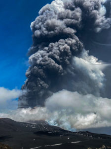
Chile , Copahue :
Special Volcanic Activity Report (REAV), Bio Bio Region, Copahue Volcano, 22 October 2019 at 19:00 local time (mainland Chile).
The National Geological and Mining Service of Chile (Sernageomin) discloses the following PRELIMINARY information obtained from the monitoring equipment of the National Volcanic Monitoring Network (NVRN) processed and analyzed at the Volcanological Observatory of the South Andes (OVDAS) ):
On Tuesday 22 October at 18:33 local time (21:33 UTC), monitoring stations near the Copahue volcano recorded a series of earthquakes associated with rock fracturing (volcano-tectonic type).

The characteristics of the earthquake of higher energy are as follows:
TIME OF ORIGIN: 18:33 local time (21:33 UTC)
LATITUDE: 37,821 ° S
LONGITUDE: 71,122 ° W
DEPTH: 0.5 km
LOCAL MAGNITUDE: 3.3 (ML)
OBSERVATIONS:
With the occurrence of this event, others with lower energy associated with the same seismic source were recorded, a usual phenomenon regarding the recording of this type of seismicity.
Volcanic Technical Alert is maintained at Yellow level.
Sernageomin monitors online and informs in a timely manner of possible changes in volcanic activity.
Source : Sernageomin
Photo : Dario G. Lazo
Italy , Stromboli :
Daily activity bulletin Stromboli volcano of 22/10/2019
SUMMARY OF THE STATUS OF ACTIVITY:
In light of the surveillance data, we highlight:
1) VOLCANOLOGICAL OBSERVATIONS: Normal explosive activity of Strombolian type accompanied by degassing activities.
2) SISMOLOGY: The seismological parameters do not show any significant changes.
3) DEFORMATIONS: The deformation monitoring networks of the island did not show any significant variation in communication during the last 24 hours.
4) GEOCHEMISTRY: The flow of SO2 is at an average level. There is no measure of CO2 / SO2 ratio available. The last value for the day of 16/10/2019 was at very high levels. The isotopic ratios of the helium dissolved in the thermal layer remain unchanged on the mean-low values (analysis of 07/10/2019).
Etna-Stromboli Eruptions / Ausbrüche October 2019 from FotoDive on Vimeo.
The analysis of the images of the surveillance cameras at 400 m altitude (SQV and SQT) and at Punta dei Corvi (SCPT), updated at 22:00 UTC on 22/10/2019, detected an ordinary Strombolian activity originating from most active mouths in North and South Craters.
The total number of explosive events until 00:00 on October 21 was 18 events / h (medium-high frequency). In detail in the North Zone, the explosive activity was 4 to 6 events / h average intensity explosions and only more than 150 m, emitting coarse materials (lapilli and bombs) sometimes covering the cone area. In the South Center zone, a low explosive frequency was observed, with 6 to 9 medium intensity events, some of which exceeded 150 m, emitting coarse materials mixed for purposes.
The total number of explosive events from 00:00 to 9:00 on October 22 was 17 events / h (medium-high frequency) … / …
https://www.facebook.com/jerome.pelloud/videos/2448602912075318/
Seismology:
The bulletin is established with data acquired from a maximum of 8 stations. The seismic activity recorded during the last 24 hours had the following characteristics: No signal associated with landslides was observed. The seismic rate of VLP type events is 20 events / hour. The amplitude of the VLP events is generally between low and medium / low. The amplitude of the earthquakes of explosions is generally weak with certain events of average amplitude / weak.
The level of volcanic tremor, estimated at STR1, has generally remained at medium-low values.
Source : INGV.
Read the full article : file:///C:/Users/Utilisateur/AppData/Local/Packages/Microsoft.MicrosoftEdge_8wekyb3d8bbwe/TempState/Downloads/BollettinoGiornalieroStromboli20191022%20(1).pdf
Vidéos : Willie FotoDive. Jérôme Pelloud.
Kamchatka , Sheveluch :
VOLCANO OBSERVATORY NOTICE FOR AVIATION (VONA).
Issued: October 22 , 2019
Volcano: Sheveluch (CAVW #300270)
Current aviation colour code: ORANGE
Previous aviation colour code: orange
Source: KVERT
Notice Number: 2019-160
Volcano Location: N 56 deg 38 min E 161 deg 18 min
Area: Kamchatka, Russia
Summit Elevation: 10768.24 ft (3283 m), the dome elevation ~8200 ft (2500 m)
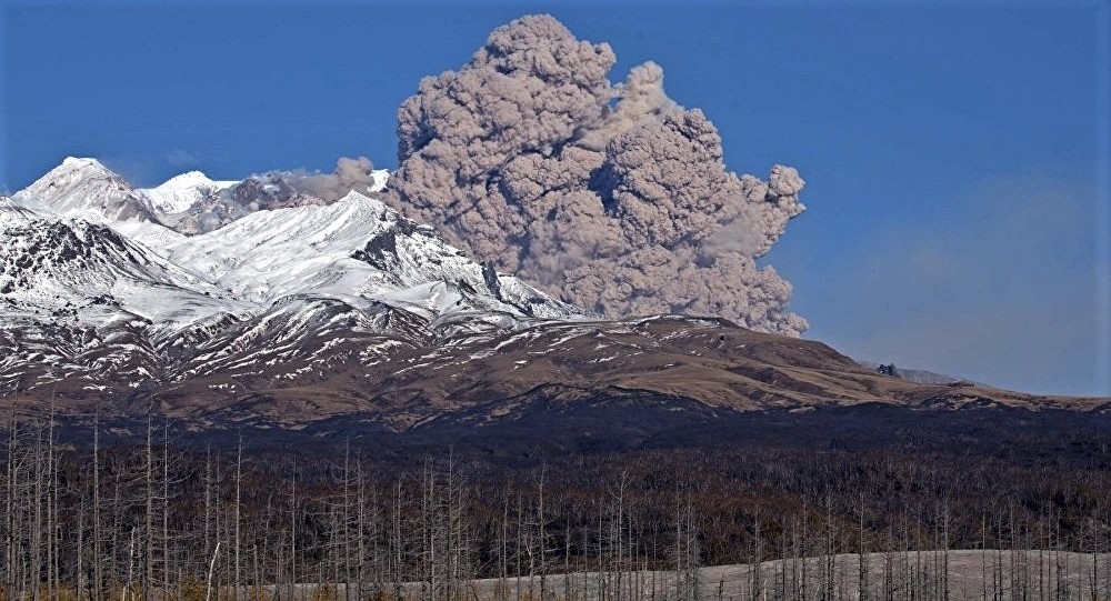
Volcanic Activity Summary:
A growth of the lava dome continues, a strong fumarolic activity sometimes with some amount of ash, and an incandescence of the dome blocks and hot avalanches accompanies this process. According to satellite data, an ash plume up to 3.0-3.5 km a.s.l. continues to drift to the south-east from the volcano.
Explosive-extrusive eruption of the volcano continues. Ash explosions up to 32,800-49,200 ft (10-15 km) a.s.l. could occur at any time. Ongoing activity could affect international and low-flying aircraft.
Volcanic cloud height:
9840-11480 ft (3000-3500 m) AMSL Time and method of ash plume/cloud height determination: 20191022/0155Z – Video data
Other volcanic cloud information:
Distance of ash plume/cloud of the volcano: 48 mi (78 km)
Direction of drift of ash plume/cloud of the volcano: SE / azimuth 127 deg
Time and method of ash plume/cloud determination: 20191022/0130Z – Himawari-8
Source : Kvert.
Photo : Yu Demianchuck.