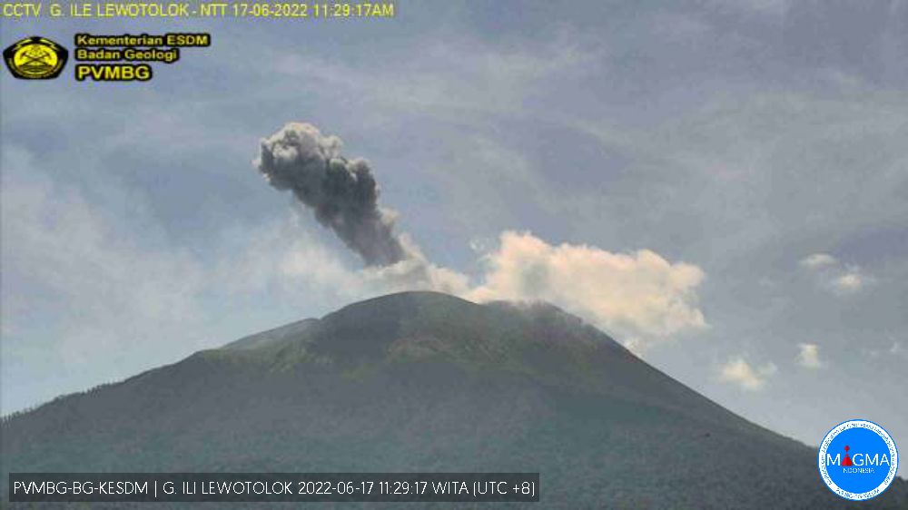
June 17 , 2022.
Indonesia , Ili Lewotolok :
VOLCANO OBSERVATORY NOTICE FOR AVIATION – VONA
Issued : June 17 , 2022
Volcano : Ili Lewotolok (264230)
Current Aviation Colour Code : ORANGE
Previous Aviation Colour Code : orange
Source : Ili Lewotolok Volcano Observatory
Notice Number : 2022LEW20
Volcano Location : S 08 deg 16 min 19 sec E 123 deg 30 min 18 sec
Area : East Nusa Tenggara, Indonesia
Summit Elevation : 4554 FT (1423 M)
Volcanic Activity Summary :
Eruption with volcanic ash cloud at 03h27 UTC (11h27 local). Eruption and ash emission is not continuing.
Volcanic Cloud Height :
Best estimate of ash-cloud top is around 7754 FT (2423 M) above sea level, may be higher than what can be observed clearly. Source of height data: ground observer.
Other Volcanic Cloud Information :
Ash-cloud moving to west
Remarks :
Seismic activity is Dominated by gas emission and Volcanic tremor earthquake
SEISMICITY OBSERVATION
It was recorded:
5 earthquakes of eruptions/explosions with an amplitude of 14.6-33 mm and a duration of 34-54 seconds.
54 emissions earthquake with an amplitude of 2.2 to 17.4 mm and a duration of 21.1 to 103.3 seconds.
20 non-harmonic tremors with an amplitude of 1.7 to 10.3 mm and a duration of 93.4 to 232.9 seconds.
1 distant tectonic earthquake with an amplitude of 3.6 mm, duration of 105.7 seconds.
1 continuous tremor with an amplitude of 0.5 to 1 mm, mainly 0.5 mm.
Source et photo : Magma Indonésie.
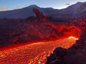
Italy / Sicily , Etna :
Communication on the activity of Etna, June 16, 2022, 14:30 (12:30 UTC).
The National Institute of Geophysics and Volcanology, Osservatorio Etneo, announces that from the inspections carried out by the staff of the INGV Etneo Observatory on June 13, 14 and 16 and from the surveillance cameras, it has been observed that the effusive activity at the mouth of about 2700 m a.s.l., reported in the previous press release, ceased on June 13, while between June 15 and 16 the flow of lava at the mouths of about 1900 m of altitude also ended in the area of Serracozzo. In addition, no ash emission from the Southeast Crater has been recorded.
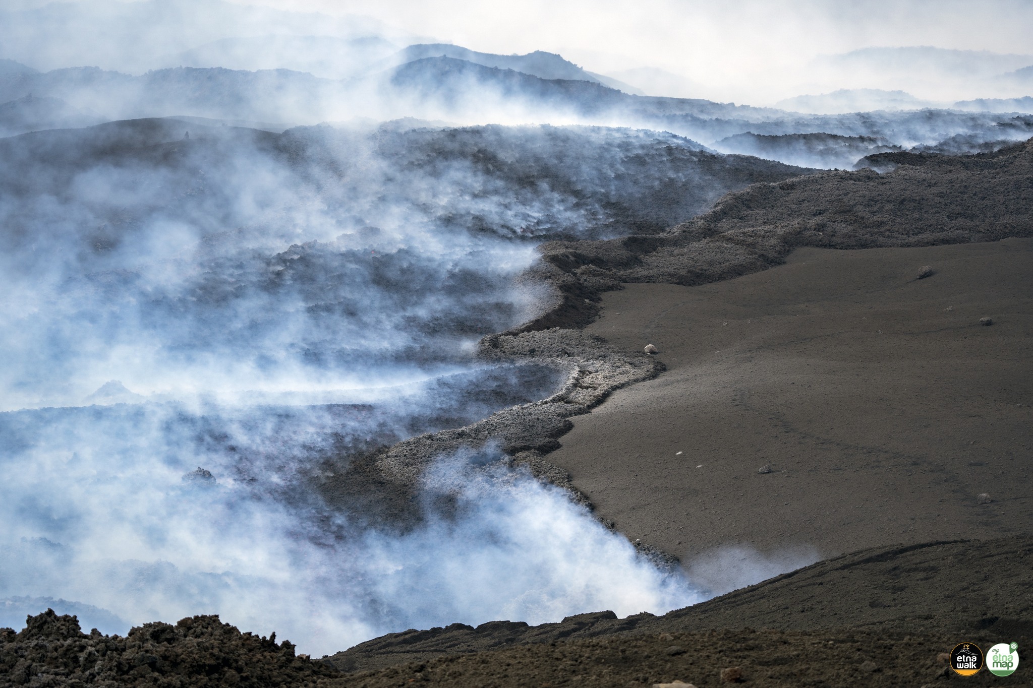
The average amplitude of the volcanic tremor was in the range of average values. The sources of the tremor are located between the Bocca Nuova and the Southeast Crater, at an altitude between 2900 and 3000 m. The infrasound activity is weak and localized mainly in correspondence with the crater of Bocca Nuova.
The stations of the inclinometer and GNSS networks do not show any significant deformations of the ground.
Further updates will be communicated soon.
Source : INGV.
Photo : Giuseppe Distefano / Marco Restivo / Marco Di Marco
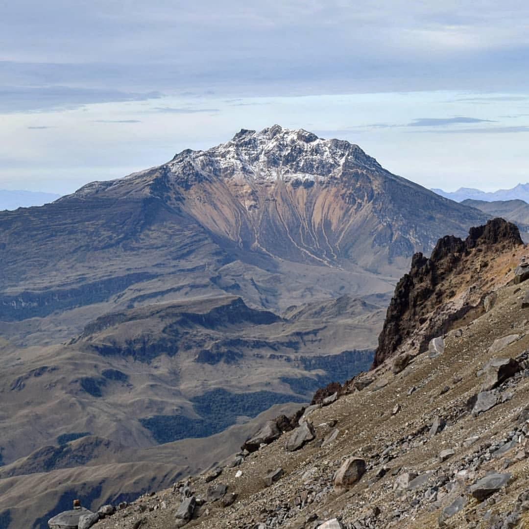
Colombia , Nevado del Ruiz :
Nevado del Ruiz volcano activity bulletin.
The activity level continues at the yellow activity level or (III): changes in the behavior of volcanic activity.
Regarding the monitoring of the activity of the Nevado del Ruiz volcano, the COLOMBIAN GEOLOGICAL SERVICE reports that:
Seismicity related to fluid dynamics within volcanic conduits decreased in terms of the number of earthquakes and maintained similar levels of seismic energy released, compared to the previous week. This seismic activity was characterized by the appearance of continuous volcanic tremors, tremor pulses, long and very long period earthquakes. In general, these signals exhibited moderate to low energy levels, variable spectral content, and were located primarily within Arenas Crater. Thanks to the cameras installed in the area of the volcano and the report of the officials of the National Natural Park of Los Nevados, the gas and ash emissions associated with some of these seismic signals have been confirmed. Likewise, through the FLIR cameras (thermographic image cameras) of the volcanic monitoring network, changes in the relative temperature of the emitted material have been observed.
Seismicity associated with rock fracturing decreased in terms of the number of earthquakes and maintained similar levels in released seismic energy, compared to the previous week. This seismic activity was located mainly in the Arenas crater and its surroundings and, in a scattered manner, in the North-East, East-North-East, East-South-East and South-South-East sectors. The depth of the earthquakes varied between 0.6 and 6.6 km. The maximum magnitude recorded during the week was 1.6 ML (Local Magnitude), corresponding to the earthquake that occurred on June 13 at 04:25 (local time), located 2.3 km south-south-east of the Arenas crater, at a depth of 3.3 km.
The recording of several episodes of low energy and short duration « drumbeat » type seismicity associated with rock fracturing and fluid seismicity on June 06, 07 and 11, 13 and 14 stands out. This seismicity has been linked to the processes of ascent, emplacement-growth and evolution of a lava dome at the bottom of the Arenas crater.
It is important to mention that, although during the last week the seismicity of the Nevado del Ruiz volcano showed a general decrease in the number of earthquakes and similar levels of seismic energy released, during the last hours , seismic activity was recorded in the Crater Arenas region.
This activity results in an increase in the energy of continuous tremor and in the number of earthquakes associated with rock fracturing and fluid dynamics.
Source : SGC
Photo : infobae.com.
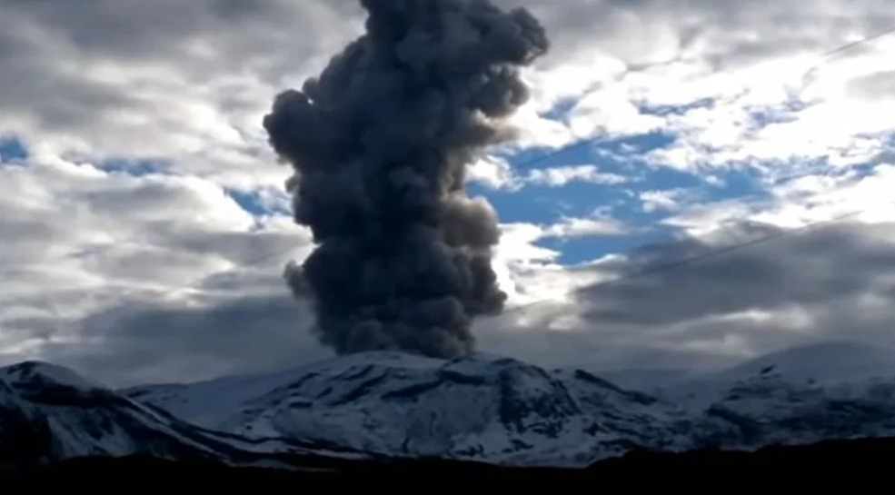
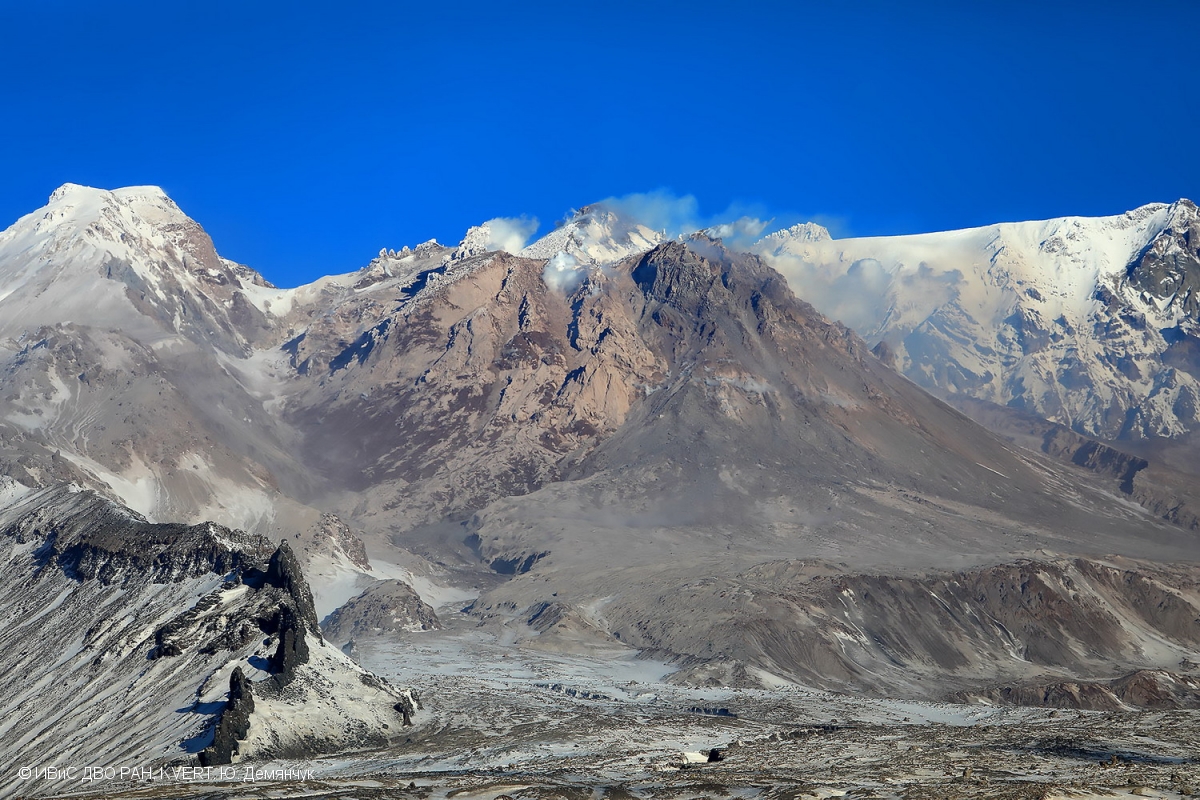
Kamchatka , Sheveluch :
56.64 N, 161.32 E;
Elevation 3283 m (10768 ft), the dome elevation ~2500 m (8200 ft)
Aviation Colour Code is ORANGE
The extrusive eruption of the volcano continues. Ash explosions up to 10-15 km (32,800-49,200 ft) a.s.l. could occur at any time. Ongoing activity could affect international and low-flying aircraft.
A growth of the lava dome continues, a strong fumarole activity, and an incandescence of the lava dome, explosions, and hot avalanches accompanies this process. According to video data, explosions send ash up to 6.5 km a.s.l. on 10 June, the ash plume moved to the southeast of the volcano. Satellite data by KVERT showed the ash cloud moved for 130 km south-southeast of the volcano on 10 June; a thermal anomaly over the volcano all week.
Source : Kvert.
Photo : Yu Demianchuck. IVS FEB RAS, KVERT.
Colombia , Chiles / Cerro Negro :
Chiles and Cerro Negro volcanoes weekly activity bulletin
Volcano activity continues at YELLOW LEVEL ■ (III): CHANGES IN THE BEHAVIOR OF VOLCANIC ACTIVITY.
From monitoring the activity of the CHILES AND CERRO NEGRO VOLCANOES, the COLOMBIAN GEOLOGICAL SERVICE (SGC) reports that:
Between June 7 and June 14, 2022, the seismic swarm process that began on May 27 continued, showing fluctuations in the number and daily energy of earthquakes, reaching a total of 8,951 events for this week, in its form most associated with the fracture of crustal material inside the volcano. The earthquakes were located in two areas, the first located south of the Chiles volcano, up to distances of 4 km and depths less than 6 km from its summit (4700 m); The second zone is also located south of the Chiles volcano, at a distance of between 5 and 9 km and a depth of between 7 and 9 km from its summit (4700 m).
During the week evaluated, 8 events of local magnitude between 2.1 and 3.4 occurred, three of which were felt in the volcanic influence zone, as reported in the extraordinary bulletin of June 12. Today at 01:03 an event with a local magnitude of 3.3 was recorded, which was also reported.
No manifestation of surface activity was observed, nor significant variations in other parameters of volcanic monitoring.
The COLOMBIAN GEOLOGICAL SERVICE and the GEOPHYSICAL INSTITUTE OF THE NATIONAL POLYTECHNICAL SCHOOL of ECUADOR remain attentive to the evolution of the volcanic phenomenon and will inform changes that may occur in due course.
Source : SGC.
Photo : Travelgrafia/Viajes por Colombia .