June 27 , 2019.
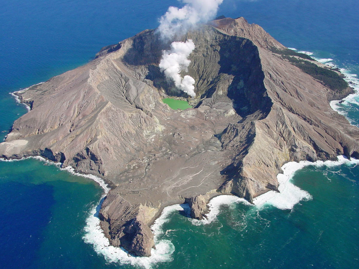
New Zealand, White Island :
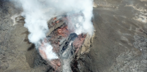
Whakaari/White Island Volcanic Alert Level raised to Level 2. Published: Wed Jun 26 2019 6:50 PM
Volcanic Alert BulletinWI – 2019/05
Volcanic Alert Level is raised to 2
Aviation Colour Code is raised to Yellow
Whakaari/White Island is experiencing moderate volcanic unrest and the Volcanic Alert Level is raised to Level 2.
Our heightened monitoring of Whakaari as part of the response to recent earthquake swarms has shown an increase in sulphur dioxide gas flux to historically high levels.
A gas flight today detected 1886 tons/day of sulphur dioxide, nearly 3 times the previous values measured in May 2019. This is the highest value recorded since 2013 and the 2nd highest since regular measurements began in 2003.
Further gas measurements will be undertaken as soon as conditions allow. Nearby earthquake swarms are continuing although at lower levels than we reported on in previous bulletins. It is still unclear of the relationship of the earthquake swarms to the high sulphur dioxide observed today.
The change in gas flux represents a significant change in our background monitoring parameters at Whakaari and is consistent with moderate or heightened volcanic unrest. As such we have changed the Volcanic Alert Level to Level 2 and the Aviation Colour Code is raised to Yellow.
Volcano Alert Level 2 is mostly associated with volcanic unrest hazards with potential for eruption hazards.
GNS Science and the National Geohazard Monitoring Centre continues to closely monitor Whakaari/White Island for further signs of activity.
Source : Geonet , Agnes Mazot , Volcanologiste de service.
Photo : Auteur Inconnu.
Papua New Guinea , Ulawun :
Hundreds evacuated in PNG after volcano erupts
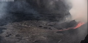
Dozens – potentially hundreds – of people in a remote part of Papua New Guinea’s New Britain were fleeing from their villages on Wednesday, after one of the country’s most active volcanoes erupted into life.
Mt Ulawun, which straddles the boundary of East and West New Britain provinces started erupting at about 8 in the morning, local time, said Steve Saunders, from the nearby Rabaul Volcano Observatory.
Mr Saunders said the volcano had been showing signs of increased activity for the past few weeks, but the eruption started in earnest on Wednesday, when the 2,334 metre volcano started spewing ash as high as 13km into the air.
« There’s been some force behind it, » Mr Saunders said, adding that the volcano was still erupting steadily on Wednesday evening.
Thousands of people live around the base of Mt Ulawun, which lies a five-hour drive away from the West New Britain capital, Kimbe. Authorities told RNZ that officials had been dispatched to help with the evacuations, although many villages had already started evacuating their homes themselves.
Residents in a local Facebook forum described the sky turning black, as well as what they said was a lava flow near Noau village and Eana Valley.
Christopher Lagisa, a resident, said in a message that people had been working all day to shepherd people to a local church.
« Around 3,000 plus were gathered at the Church hall and all vehicles from Ulamona, a six ton truck, a long wheel bases Isuzu and Mama truck, Fathers Land Cruizer Ute and my 5 Door LC have been working flatout moving people to Kabaya Community, » he wrote. The numbers have not been confirmed by officials.
« The immediate need now would be food, water and medicine as we were just recovering from the long wet season. »
Flights to New Britain had been cancelled, according to local media reports, and Australia’s Bureau of Meteorology had issued a « red » warning to airlines.
At Ulawun, Mr Saunders said his teams were nervously watching. The volcano was steadily rumbling away, he said, belching ash and gases, but could either settle down or intensify in the coming hours.
« It’s still early days [as] to what it’s going to do, » he said.
Mt Ulawun Eruption (26/06/19)
Ulamona – WNB PNG.
According to sources on the ground;
Evacuation started this morning. New Britain highway shut down by lava flow during the day. All road links to Ulamona, Noau and Bakada are closed. All flights in and out of WNB closed as of midday. The only route is by sea.
Greater need for humanitarian assistance from NGOs and churches now apart from the WNBP Government. The National Disaster office has yet to give an official statement regarding the situation.
Picture and comment reposted from
Mr. Freddie Kumai
Source : Radio NZ.
Photos : Eroli Tamara , Freddie Kumai (Facebook).
Russia /Kuril Islands , Raikoke :
48.292°N, 153.25°E
Elevation 551 m
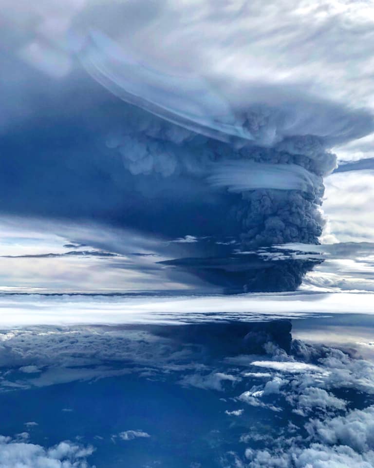
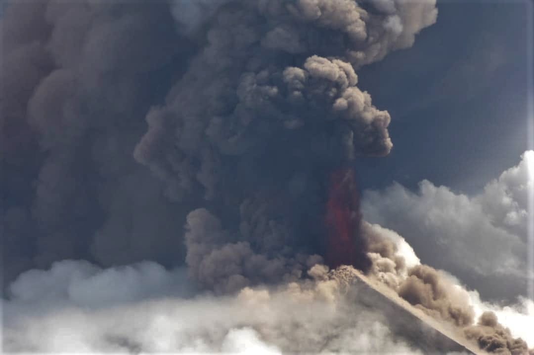
A powerful eruption at Raikoke that began on 22 June (after 95 years of dormancy) was identified based on satellite observations, prompting KVERT and SVERT to raise the Aviation Color Code to Red. A series of at least nine explosions (six within the first 25 minutes) beginning at 05h05 and continuing to about 19h00 produced ash plumes, with a significant sulfur dioxide component, that rose 10-13 km (32,800-42,700 ft) a.s.l. and drifted E and NE.
Lightning was detected in the eruption plumes. Strong explosions at 1640 on 22 June generated ash plumes that rose to 10-11 km (32,800-36,100 ft) a.s.l. The ash and gas was entrained by jet streams and by a cyclone around the Komandorskiye Islands, causing parts of the material to spiral counterclockwise as it drifted farther NE. By 23 June the leading edge of the plume had drifted 2,000 km ENE. According to a news article, at least 40 flights in that region were diverted.
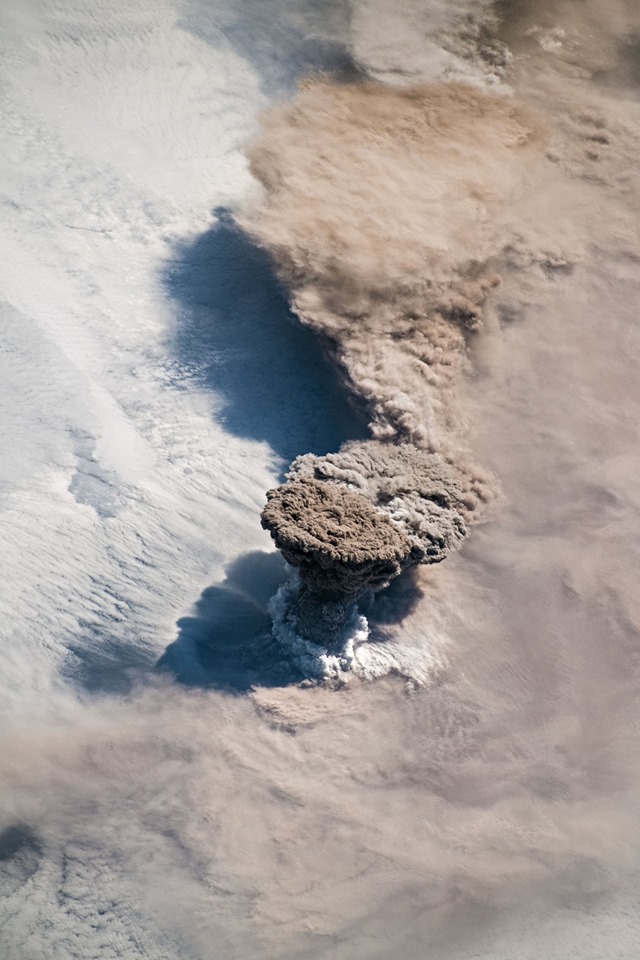
On 23 June ash plumes continued to be visible, rising to 4.5 km and drifting NE. The Aviation Color Code was lowered to Orange. Gas-and-steam plumes possibly with some ash rose to 4.5 km (14,800 ft) a.s.l. and drifted 60 km NW. That same day observers on a passing ship approached the island from the W side; they photographed the island and sent out a drone. An expedition member noted that the entire island was mantled with light-colored ash deposits up to several dozen centimeters thick.
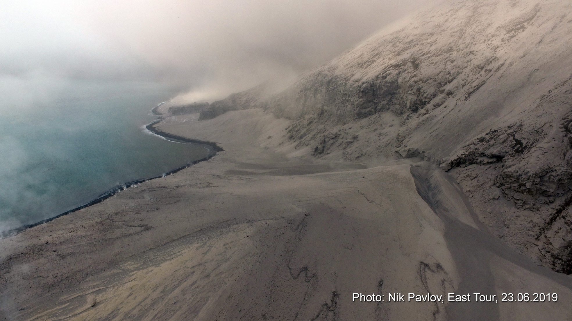
In some of the drainages and at the base of some drainages deposits were several meters thick. In some areas along the shoreline waves interacted with the deposits, causing steam explosions and dark brown steam emissions. Gas-and-ash plumes rose 1.5 km above the summit crater rim and drifted W. Minor ashfall was reported in Severo-Kurilsk (340 km NE) during 1830-1920. On 25 June ash plumes continued to be produced, rising as high as 2 km (6,600 ft) a.s.l. and drifting NW.
Sources: Kamchatkan Volcanic Eruption Response Team (KVERT), Sakhalin Volcanic Eruption Response Team (SVERT), Japan Broadcasting Corporation (NHK), GVP.
Photos : International Space Station (ISS) , Nik Pavlov .
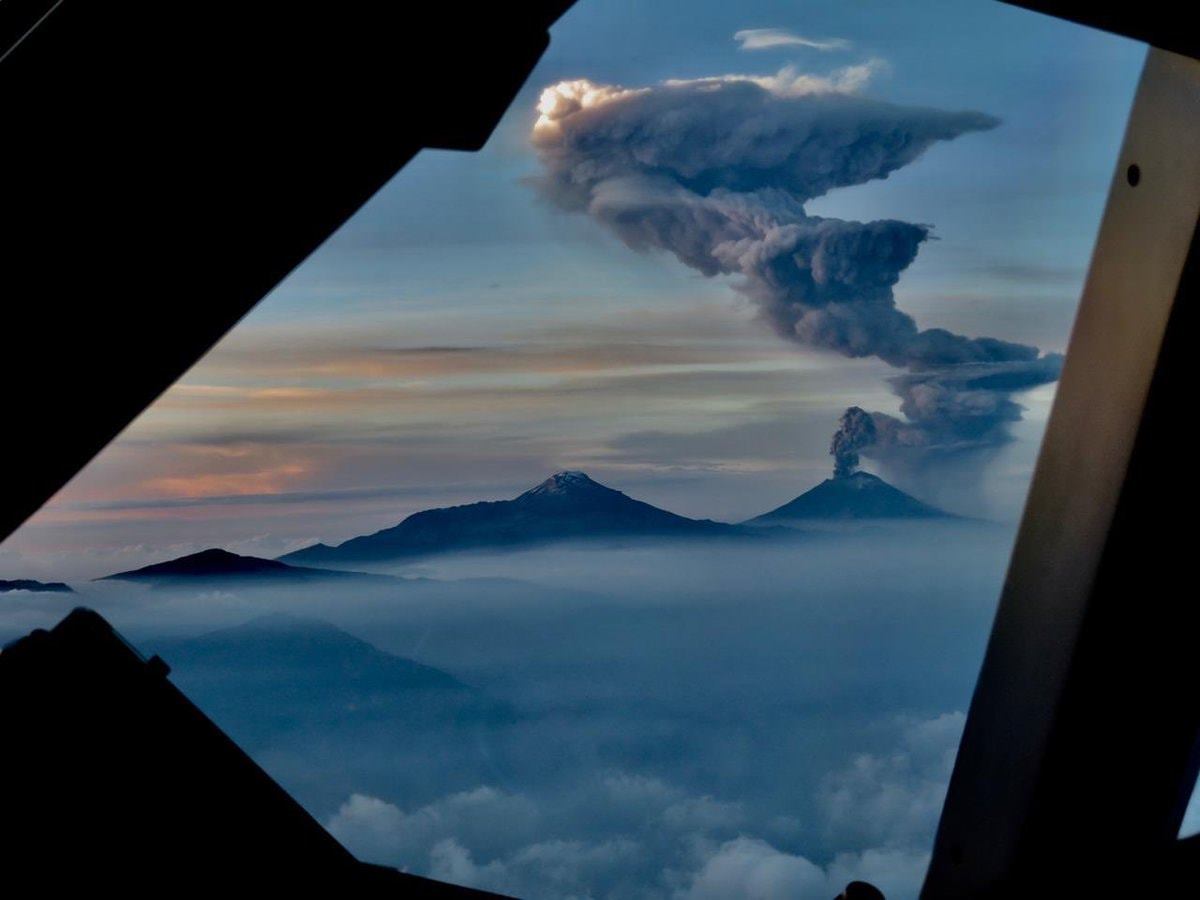
Mexico , Popocatepetl :
19.023°N, 98.622°W
Elevation 5393 m
CENAPRED reported that each day during 19-25 June there were 26-201 steam-and-gas emissions from Popocatépetl, some of which contained minor amounts of ash. An explosion at 2058 on 21 June produced an ash plume that rose 2.5 km above the crater rim and drifted W, and ejected incandescent material less than 1 km onto the flanks. Minor ashfall was reported in areas downwind including the municipalities of Ozumba (18 km W), Atlautla (16 km W), and Ecatzingo (15 km SW) in the State of Mexico, and in Tetela del Volcán (20 km SW) in the State of Morelos. The Alert Level remained at Yellow, Phase Two (middle level on a three-color scale).
June 26 at 10:00 am (June 26 at 16:00 GMT)
In the last 24 hours, thanks to the surveillance systems of the Popocatépetl volcano, 155 exhalations have been identified, accompanied by water vapor, gas and light amounts of ash. In addition, 42 minutes of tremor were recorded.
During the night, a continuous emission of water vapor and volcanic gases was observed.
In the morning, the crater was visible. However, at the time of writing this report, there was no visibility. In case of emission, the wind would scatter them preferably towards the South-West.
The monitoring system of the Popocatepetl volcano operates 24 hours a day. CENAPRED closely monitors any event. Any changes to the monitoring parameters will be reported promptly.
CENAPRED urges NOT to APPROACH the volcano and especially the crater, because of the danger of falling ballistic fragments, and in case of heavy rains, to stay away from ravine bottoms because of the danger of mudslides and debris.
The Popocatepetl warning light is located at YELLOW PHASE 2.
Sources : GVP , Cenapred.
Photo : pilote Jaime del Río , 18/06/2019.