January 16 , 2019 .
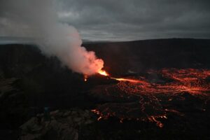
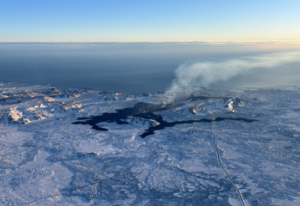
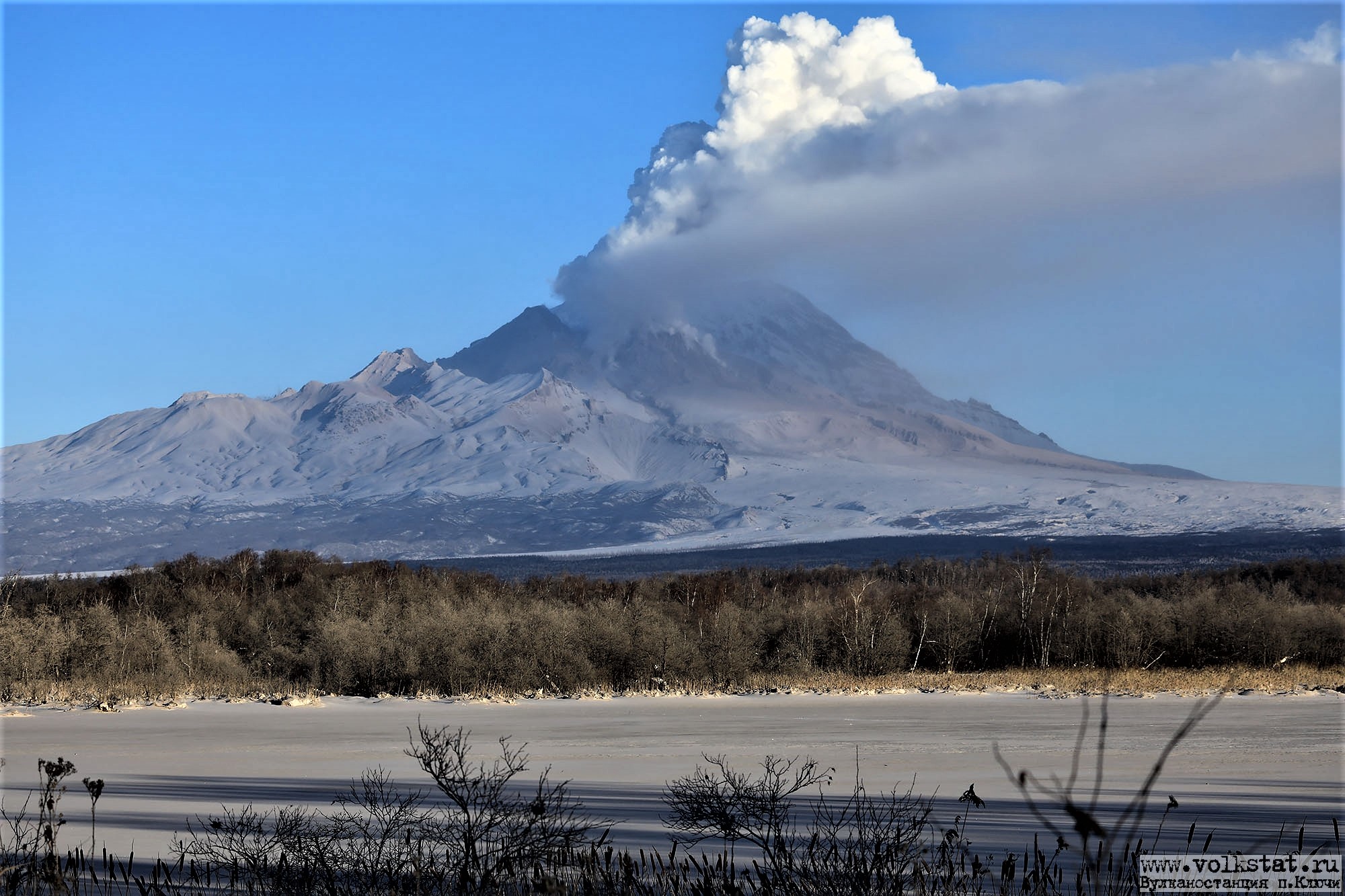
Kamchatka , Sheveluch :
VOLCANO OBSERVATORY NOTICE FOR AVIATION (VONA).
Issued: January 15 , 2019
Volcano:Sheveluch (CAVW #300270)
Current aviation colour code:ORANGE
Previous aviation colour code:orange
Source:KVERT
Notice Number:2019-19
Volcano Location:N 56 deg 38 min E 161 deg 18 min
Area:Kamchatka, Russia
Summit Elevation:10768.24 ft (3283 m), the dome elevation ~8200 ft (2500 m)
Volcanic Activity Summary:
A growth of the lava dome continues (a viscous lava blocks extrude out on the northern part of it), a strong fumarolic activity and an incandescence of the dome blocks and hot avalanches accompanies this process. According to satellite data, a gas-steam plume with some amount of ash on the height 3.5-4.0 km a.s.l. continues to drift to the east-south-east from the volcano.
Explosive-extrusive eruption of the volcano continues. Ash explosions up to 32,800-49,200 ft (10-15 km) a.s.l. could occur at any time. Ongoing activity could affect international and low-flying aircraft.
Volcanic cloud height:
11480-13120 ft (3500-4000 m) AMSL Time and method of ash plume/cloud height determination: 20190115/2140Z – Video data
Other volcanic cloud information:
Distance of ash plume/cloud of the volcano: 171 mi (275 km)
Direction of drift of ash plume/cloud of the volcano: ESE / azimuth 105 deg
Time and method of ash plume/cloud determination: 20190115/2110Z – Himawari-8.
Source : Kvert
Photo : Yu . Demyanchuck. Volkstat ru.
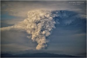
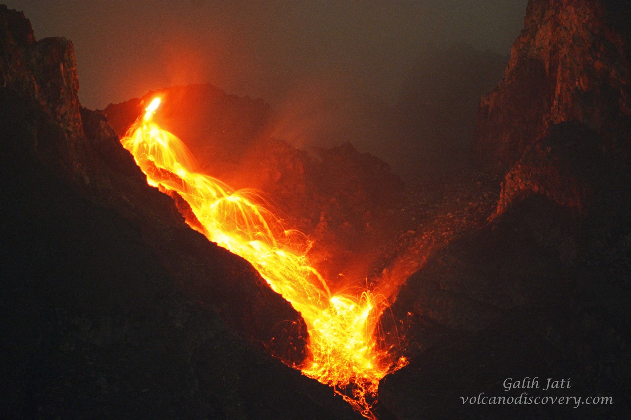
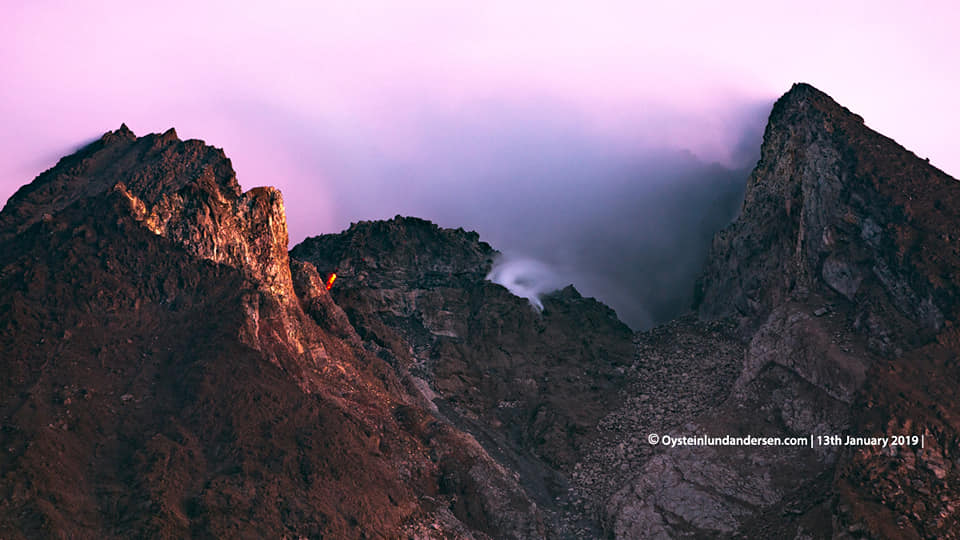
Indonesia , Merapi :
Mount Merapi, which stands on the border between Yogyakarta and Central Java, has shown heightened volcanic activity over the past few days, spewing incandescent lava from its crater.
Sidorejo subdistrict head Jemakir said that apart from incandescent lava, the volcano was emitting booming sounds resembling thunder more frequently, which had prompted local residents to also increase the frequency of their independently organized patrols.
“The people are still calm because the lava so far has flowed only 500 meters to 800 meters down the slope. But we remain alert, in case Merapi erupts [suddenly],” he said on Tuesday.
Sidorejo subdistrict extends to the slopes Mt. Merapi in the northern part of Klaten regency, Central Java.
Dimas Joko, a volunteer monitoring Mt. Merapi, said that the volume and the extent of the lava flow were both relatively normal, but that the volunteer team had banned all human activity within a 3-kilometer radius from the crater.
“They may [still] harvest grass or farm, but they are not allowed within a radius of three kilometers from the crater,” he said.
Citing recommendations from the Center of Volcanology and Geological Hazard Mitigation (PVMBG), Joko said that people were advised to stay away from the upper slopes of the mountain for their own safety, especially considering the lava flow.
Mt. Merapi’s warning status on Tuesday was still Waspada (Caution), the second of the four-tiered national volcano alert system that has been in place since May 2018.
The Central Java Disaster Mitigation Agency (BPBD Central Java) is working with other regencies to prepare evacuation routes and emergency shelters in anticipation of a major eruption.
BPBD Central Java head Sarwa Pramana stated that the established Mt. Merapi evacuation routes were heavily damaged, because of the hundreds of trucks transporting volcanic ash. The area was also seeing rainfall almost daily, which had worsened conditions.
“Restoring the evacuation routes is very urgent, especially in Klaten. The routes are needed to evacuate people when Merapi’s alert level reaches Awas [Danger],” he said.
Sarwa added that the agency had started calculating logistical needs in case the eruptions worsened, including masks, community kitchens, emergency tents and rehabilitation posts.
“[The calculations] are necessary for smoother mitigation [efforts] at the time of a disaster,” he said. BPBD Central Java had also installed three additional CCTV cameras in Klaten, Magelang and Boyolali to monitor the volcano.
At least 353 people were killed and more than 350,000 others were displaced in the 2010 eruption. Most of the victims lived on the volcano’s slopes..
Level II Activity Level (WASPADA). The Merapi volcano (2968 m altitude) suffered eruptions.
Since yesterday and until this morning, the volcano was clearly visible then covered with fog. The smoke from the crater is not observed. The wind is blowing weakly to moderately from north and south-east.
The seismographs, January 15, 2019 recorded:
40 avalanche earthquakes
2 emission earthquakes
1 low frequency earthquake.
Source : The Jakartapost. PVMBG.
Photos : Yohannes Tyas Galih Jati / Volcanodiscovery , Øystein Lund Andersen.
Colombia , Nevado del Huila :
Weekly activity bulletin of the Nevado del Huila volcano.
The level of activity of the volcano continues at the level: yellow activity level or (III): changes in the behavior of volcanic activity.
According to the analysis and evaluation of the information obtained through the monitoring network of the Nevado del Huila volcano, from 8 to 14 January 2019, the COLOMBIAN GEOLOGICAL SERVICE – Volayological and Volcanic Observatory of Popayán indicates that:
• During the evaluated period, 481 seismic events were recorded, 179 related to rock fracturing processes (type VT) and 302 related to fluid dynamics in volcanic canals. Of these, 275 were classified as long period type events (LP type), seven (7) as hybrid types (HB type) and 20 as low energy tremor pulses (TR type).
• The images obtained during the week by the web cameras of Caloto, Tafxnú, Maravillas and La Palma showed a weak degassing of the volcanic system.
• Sensors for monitoring soil deformation, magnetic fields, and infrasound did not record any variations associated with changes in volcanic activity.
Therefore, it is concluded that the volcano exhibited stable behavior during the evaluated period. The Colombian geological service remains attentive to the evolution of the volcanic phenomenon and will inform in a timely manner the changes likely to occur.
Source : SGC
Photo : Sernageomin
Costa Rica , Poas :
Poás volcano: eruptions of water vapor and gas « geysiform » and remote measurement of fumaroles temperature. OVSICORI-UNA · Monday, January 14, 2019
Since 19 December 2018, the Poás has entered a phase of « geysiform » activity (from the Icelandic term « geysir »), which suggests that the dynamics between the magmatic and hydrothermal systems has reached a condition favoring pressurization followed by depressurisation. in a repetitive and fairly regular form, generating eruptions or exhalations rich in water vapor and magmatic gases, followed by periods of relative calm recalling the mechanism of the eruption of the « geysers. » Many geysiform eruptions took place between December 2018 and January 13, 2019. Most produce « rooster tails or surtseyenne-type eruptions » (blackish streams of hot water with lacustrine and hydrothermal sediments) about 20 to 50 m high with white columns of water vapor and gas that dilate at a height of 500 to 800 m from the bottom of the crater.
On January 9, 2019, the apparent temperature was measured in several active fumaroles from the dry crater floor since the destruction of the « 1953-1955 dome » and the total drying of the hyper acid lake resulting from phreatic-magmatic eruptions of the year. 2017.
https://www.facebook.com/OVSICORI/videos/240054360242404/
Temperature measurements were taken from the northern edge of the active crater at a distance of 450 to 470 m using a FLIR SC660 thermal imaging camera. The thermographic images (FIGS. 2 and 4) were obtained under ambient conditions of 67% relative humidity and a temperature of about 15 ° C. High resolution germanium lenses with a 45 degree field of view, calibrated for a temperature measurement range of -40 ° C to 120 ° C were used. The measurements were made between 9:30 and 11:00, with clear sky. In general, the maximum apparent temperatures recorded at Boca AC (Boca A and Boca C have merged and form a single vent), Boca B and Boca D, as well as at other sites with thermal anomalies ranging from 85 ° C to 94 ° C. (Figures 1 and 2, temperature profiles along line 1). These values correspond to the boiling temperature of the water at the altitude of the bottom of the crater (about 2350 m.s..m.).
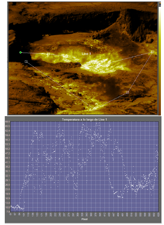
Figure 1. Thermograms of Boca AC (Boca Roja or former « 1953-1955 dome » associated with Boca C) and Boca B located in the area previously included in the « 1953-1955 dome » (destroyed during phreatomatic magmatic eruptions). 2017). ) and the depression usually occupied by the hyper acid lake. FLIR SC660 portable thermometer with 45 degree field of view lens.
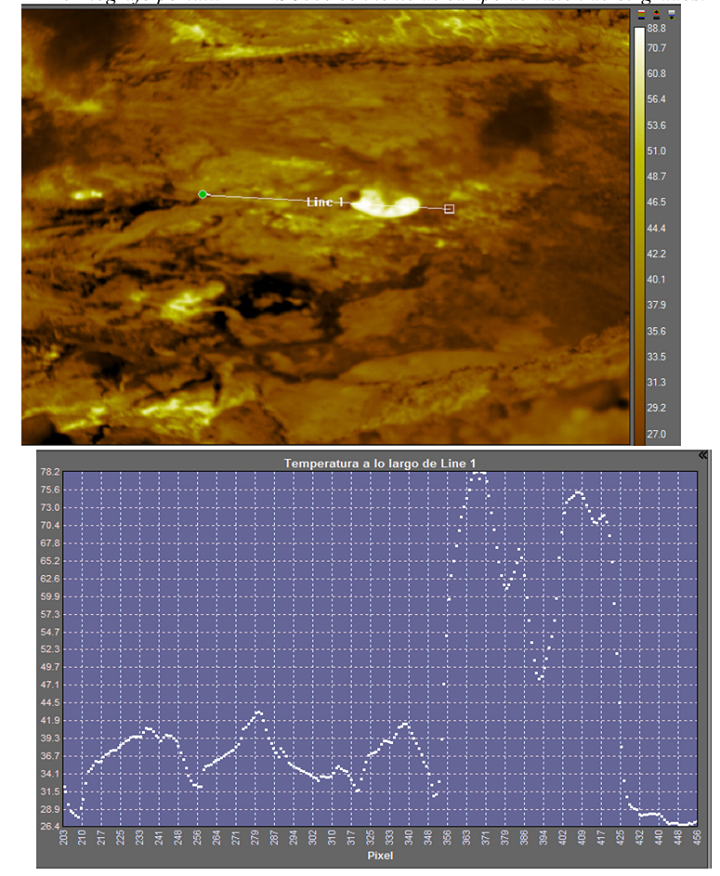
Figure 2. Thermograms of the Boca D (near the center of the depression usually occupied by the hyper acid lake.) FLAR SC660 portable thermometer with a 24 degree field of view lens, note located at the center of the steam plume emission from the Boca D. water and gases dispersing to the west (on the right of the image).
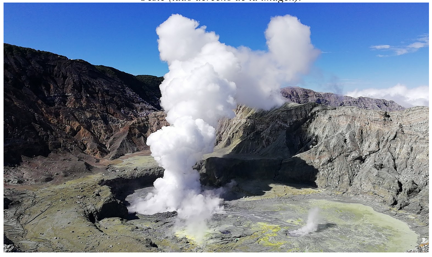
Figure 3. « Geysiform » eruption of water vapor and gas seen from the northern edge of the crater, at about 450 m, on January 9, 2019. The most active fumaroles are Boca AC, Boca B and Boca D (left to the right).
About half a dozen moderate « geysiform » eruptions with steam and gas columns between 500 and 800 meters in height were observed during this 2.5 hour period of temperature measurements taken on the 9th January 2019 (between 2 and 3 vigorous eruptions per hour) (Fig. 3). These eruptions occur repeatedly and frequently, after a relatively quiet time in the crater. We also observe from the northern edge of the crater a « cuttlefish » during one of the vigorous eruptions of steam and water. We also note that whenever an eruption of this nature begins, there is a moderate increase in the steam flow rate and a more intense convection of water simultaneously in the main fumaroles and vents, i.e. Bocas A-C, B and D. This is due to the fact that there is underground hydraulic interconnectivity between the different fumaroles at the bottom of the crater. A mild, intermittent odor of hydrogen sulfide, H2S, has been seen from the northern edge of the crater … / …
Source : Ovsicori / María Martínez Cruz, PhD Geoquímica – Vulcanología OVSICORI-UNA.
Read the full article : https://www.facebook.com/notes/ovsicori-una/volcán-poás-erupciones-de-vapor-de-agua-y-gases-geysiformes-y-medición-remota-de/1963960356974546/
Video : Maria Martinez / Ovsicori