September 24 , 2018.
La Réunion , Piton de la Fournaise :
Activity Bulletin from Sunday, September 23, 2018 at 19:00 (local time)
The eruption started on September 15th at 4:25 am local time continues. The volcanic tremor (indicator of surface eruptive intensity) has slightly increased since 8:00 am local time (04:00 UTC time) and thus doubled in intensity during the day (Figure 1).
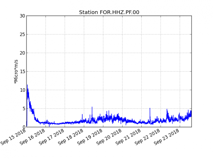
Figure 1: Evolution of the RSAM (indicator of the volcanic tremor and the intensity of the eruption) between 04h00 (00h UTC) on September 15th and 14h00 (18h00 UTC) on September 23rd on the seismic station FOR, located near the crater Chateau Fort (2000 m altitude on the southeast flank of the terminal cone). (© OVPF / IPGP)
– Two superficial volcano-tectonic earthquakes were recorded under the east flank of the volcano during the day of 21 September. No volcano-tectonic earthquakes have been recorded during the current day.
– No significant deformity is noticeable since the beginning of the eruption.
– The surface flows estimated from the satellite data, via the HOTVOLC platform (OPGC – Clermont Auvergne University) are maintained and are always between 1 m3 / s and 3 m3 / s over the last 24 hours.
– The decrease in SO2 flux by a factor of about 6 compared to the beginning of the eruption is maintained and is confirmed by the sharp decrease in SO2 pollution at the summit of Piton de la Fournaise; the plume is now smaller and almost confined in the Enclos Fouqué with a dispersion to the south and west.
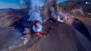
– A field mission carried out today by an OVPF team allowed the sampling of slag at the eruptive cone and an active flow arm located at the foot of the cone (Figure 2).
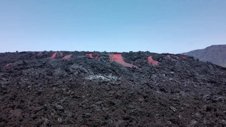
Figure 2: Shooting of the eruptive site on September 23 at 12:30 (local time). (© OVPF / IPGP)
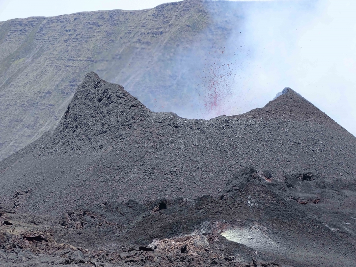
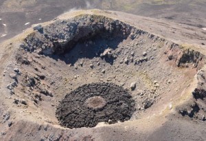
Figure 3: Shooting of the eruptive site on September 23rd at 11am (local time). (© OVPF / IPGP)
The cone continues its edification (Figure 3) and is still riddled to the south leaving a main flow south, then heading south-east.
Alert level: Alert 2-2 – Eruption in the Enclos.
Source : OVPF
Chile , Villarica :
Special Report on Volcanic Activity (REAV)
Auracania Region, Villarica Volcano, 23 September 2018, 01h51 Local time (Continental Chile)
The National Geological and Mining Service of Chile (Sernageomin) publishes the following PRELIMINARY information, obtained from monitoring equipment of the National Volcanic Monitoring Network (NVRN), processed and analyzed at the Volcanological Observatory of the Southern Andes (OVDAS) :
On Sunday, September 23rd, 2018 at 10h17 local time (20:17 UTC), the monitoring stations installed near the Villarica volcano recorded an earthquake associated with a fracturing process of rocks (Volcano-tectonic type), located at 4,7km from the crater. active, inside the caldera.
The characteristics of the earthquake after its analysis are as follows:
TIME OF ORIGIN: 17h17 Local time (20h17 UTC)
LATITUDE: 39.437 ° S
LONGITUDE: 71,890 ° W
DEPTH: 3.2 KM
LOCAL MAGNITUDE: 3.2 (ML)
OBSERVATIONS:
At the time of issuing this report, the event was not confirmed as felt by the population. No precursor earthquakes or replicas have been recorded.
The level of volcanic technical alert remains at the level: GREEN.
Sernageomin continues online monitoring and will inform in a timely manner about any changes observed.
Source : Sernageomin.
Ecuador , Reventador :
The Reventador volcano, located 90 km from Quito, has a strong eruptive activity and has expelled gas and ash in recent hours 900 meters above its crater today, September 23, 2018, said the Institute. National Geophysics. « A high eruptive activity is maintained. In the evening hours emissions and ashes were observed at a height of 900 meters above the summit, dispersing to the west and north, « . the National Institute of Geophysics said it has been observed incandescent its last days at the crater level.
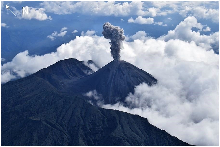
According to the daily reports published by the Institute of Geophysics of the National Polytechnic School, which follows the seismic and volcanological situation, the volcano shows a high activity. In November 2002, an eruption of the Reventador emitted a large cloud of ashes which, with the winds, extended to Quito and covered several parts of the capital. The volcano is located about 90 kilometers east of Quito, on a spur of the eastern branch of the Andes mountain range, at the beginning of the Amazon basin. At a height of 3,560 meters, it began its current eruption process in 2002 and is characterized by explosions, gas and ash emissions, lava flows and lahars.
Source : Diario EL COMERCIO https://www.elcomercio.com/actualidad/volcan-reventador-expulsa-gases-ceniza.html.
Photo : Inconnue
Indonesia, Anak Krakatau :
Level II Activity Level (WASPADA). Anak Krakatau (305 m above sea level) has experienced an increase in volcanic activity since 18 June 2018.
Since yesterday and until this morning, the volcano was visually cleared until it was covered with fog. The weak winds were oriented to the east and south-east. The smoke from the crater was gray and black, of medium pressure, with a thick intensity, and reached 1000 m high. At night, from CCTV, fires and incandescences were observed 300 m to the south, with incandescent splinters of 300m. There was a thud and a weak vibration that was heard at the PGA Post.
https://www.facebook.com/galihadventure/videos/10212817954664075/
Thanks to the seismographs of September 23, 2018, it was recorded:
– Continuous tremors with a maximum amplitude of 45 to 52 mm (dominant value of 48 mm)
Recommendations:
People / tourists are not allowed to approach within a radius of 2 km around the crater.
VONA:
The latest VONA code was color-coded ORANGE, published on September 21, 2018 at 05:48 WIB, for the eruption recorded with a seismogram of maximum amplitude of 45 mm for a duration of approximately 115 seconds. The height of the eruption column was about 505 m above sea level. The column of ash is moving south.
Source : PVMBG
Video : Yohannes Tyas Galih Jati