September 21 , 2018.
La Réunion , Piton de la Fournaise :
Activity Bulletin from Thursday 20 September 2018 to 16:15 (local time)
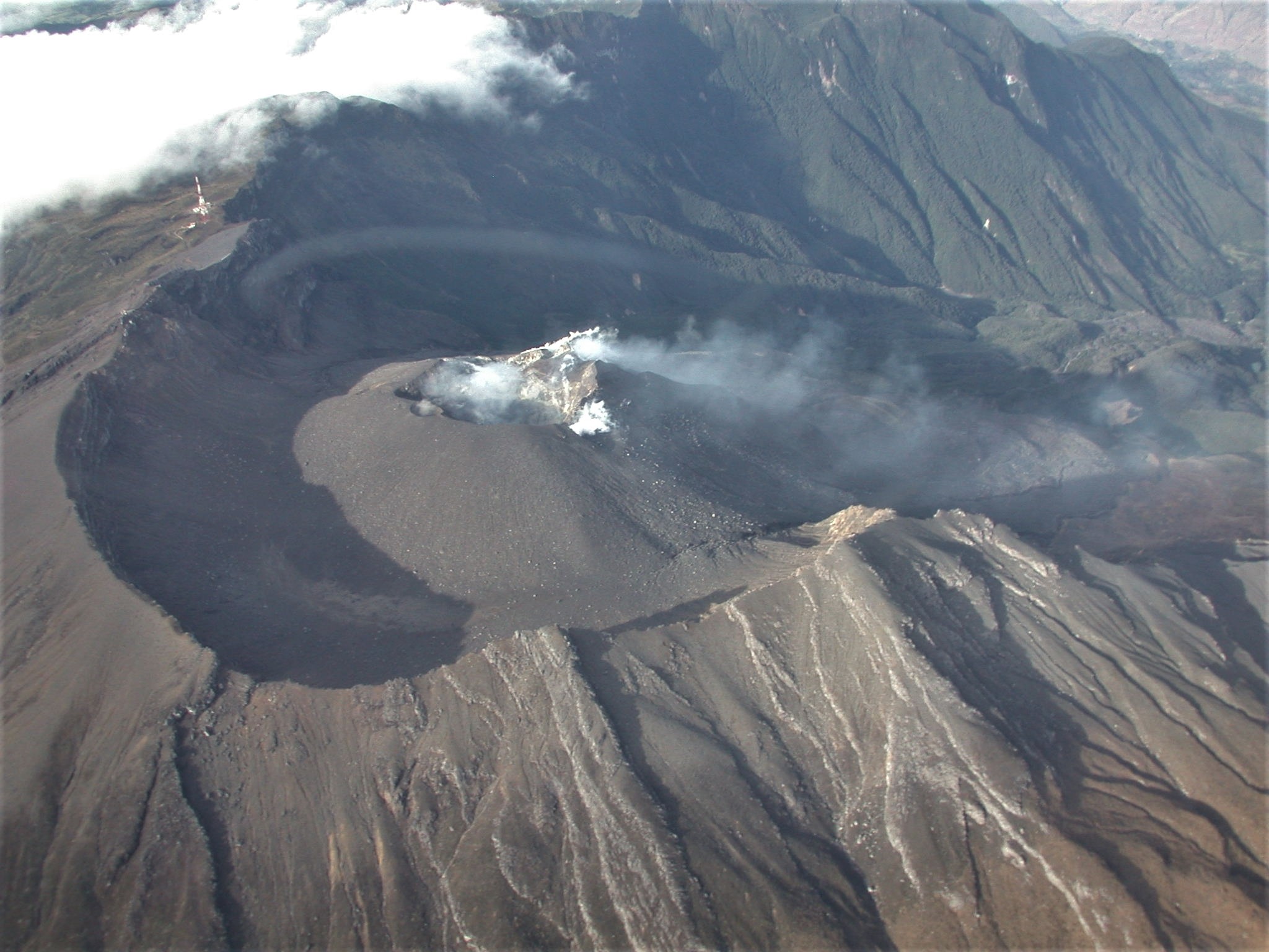
The eruption that began September 15 at 4:25 am local time continues. The volcanic tremor (indicator of the surface eruptive intensity), has largely decreased compared to the previous days.
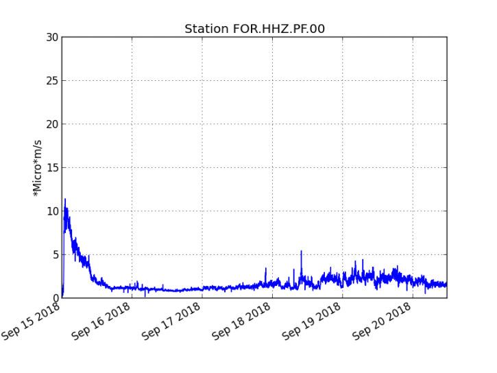
Figure 1: Evolution of RSAM (indicator of volcanic tremor and intensity of eruption) between 04:00 (00h UTC) September 15 and 16:00 (12:00 UTC) September 20 on the seismic station of FOR, located near the Château-fort crater (2000 m altitude to the southeast of the summit).
– A volcano-tectonic earthquake was recorded under the summit craters during the day of 19 September. No volcano-tectonic earthquakes have been recorded during the current day.
– The SO2 emissions recorded by the OVPF’s permanent sensors are much higher than the atmospheric background (related to the volcanic gas plume), but have largely decreased, also reflecting a decrease in the flow of lava produced at the level of the eruptive mouth.
– No significant deformity is noticeable since the beginning of the eruption.
– The surface flows were estimated from HOTVOLC satellite data (OPGC – University Clermont Auvergne), and are between 1 and 5 m3 / s during the day of September 19th.
– An outline of the flow could be determined by the OI2 platform (OPGC – University Clermont Auvergne) from the Sentinel satellite data acquired on the 19th at the beginning of the day. This new contour does not show (or very little) evolution of the different casting fronts. The main evolution is an enlargement of the casting in its most upstream part.
– The very modest evolution of the contour of the flows was confirmed by an overflight made this morning (September 20th).
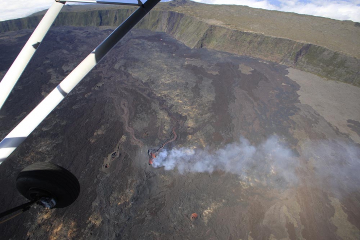
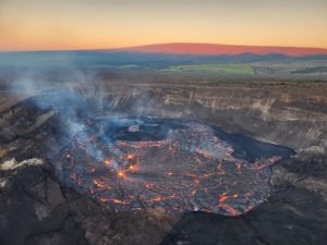
Figure 2: General view of the eruptive mouth and lava field taken this morning in the middle of the Morning.
Source : OVPF
Video : Ilotdrones
Colombia , Galeras :
The level of activity of the volcano continues at the level: LEVEL YELLOW ■ (III): CHANGES IN THE BEHAVIOR OF THE VOLCANIC ACTIVITY.
Following the activity of the GALERAS volcano, the COLOMBIAN GEOLOGICAL SERVICE (SGC) informs that:
For the period between 11 and 17 September 2018 There has been an increase in the number and energy of recorded earthquakes, with a predominance of seismicity associated with rupture of the cortical material inside the volcano, dispersed in its area of influence at distances less than 9.5 km, with depths of up to 10 km from the summit (4,200 m) and a local maximum magnitude of 4.0 on the Richter scale. During the evaluated period, 3 earthquakes were reported as felt, two on September 11 at 1:08 and 1:10 am. (Mentioned in previous report), with magnitudes of 4.0 and 2.5 on the Richter scale, respectively, located 9 km northeast of the volcano at a depth of about 10 km from the summit , and another recorded on September 13 at 17:46 with a local magnitude of 1.8, 7.8 km northeast of the volcano, at a depth of 8 km from the summit.
During the evaluated period, it was possible to observe gas emissions from the main crater and fumaroles of Las Chavas in the west and Paisita north of the active cone, with white columns, low height, low pressure and a variable direction of dispersion according to the winds The other parameters of the geophysical and geochemical type of volcanic monitoring of Galeras do not record any variations showing a modification of the activity level of the volcano.
The COLOMBIAN GEOLOGICAL SERVICE is attentive to the evolution of the volcanic phenomenon and will continue to inform in a timely manner about the observed changes.
Source : SGC
United – States / Yellowstone , Geyser Basin :
Recent Changes to Thermal Features Closes Part of Upper Geyser Basin
September 19, 2018
In the past week, there have been changes afoot to the thermal features on Geyser Hill in Yellowstone’s Upper Geyser Basin. Ear Spring, a normally docile hot pool, had a water eruption that reached 20 to 30 feet high on Saturday, September 15, 2018. The eruption ejected not only rocks, but also material that had fallen or been thrown into the geyser in years past, like coins, old cans, and other human debris. The last known similar-sized eruption of the spring was in 1957, although smaller eruptions occurred as recently as 2004. As a result of these changes, Yellowstone National Park has closed portions of the boardwalk.
Undoubtedly, the most famous thermal feature of Yellowstone National Park’s Upper Geyser Basin is Old Faithful. Geyser Hill is located just across the Firehole River from Old Faithful and hosts dozens of other hot springs, geysers, and fumaroles. Hydrothermal activity at several features on Geyser Hill has changed since the eruption of Ear Spring. Most notably, a new feature has formed west of Pump Geyser and north of Sponge Geyser directly under the boardwalk. The feature erupted overnight between September 18th and 19th and continues to pulse water as a small spouter. An approximately 8-foot diameter area of surrounding ground is « breathing » – rising and falling by about 6 inches every 10 minutes. Several other thermal features are more active than usual, including geysering and boiling of Doublet Pool and North Goggles Geyser.
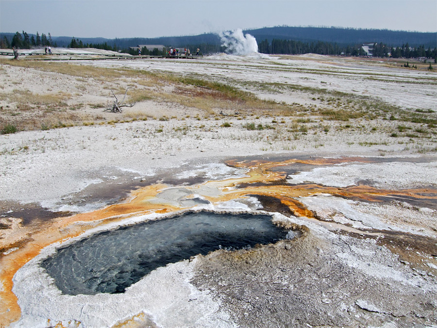
Ear Spring, located on Geyser Hill in the Upper Geyser Basin. Old Faithful can be seen steaming in the background.
Changes in Yellowstone’s hydrothermal features are common occurrences and do not reflect changes in activity of the Yellowstone volcano. Shifts in hydrothermal systems occur only the upper few hundred feet of the Earth’s crust and are not directly related to movement of magma several kilometers deep. There are no signs of impending volcanic activity. There has been no significant increase in seismicity nor broad-scale variations in ground movement.
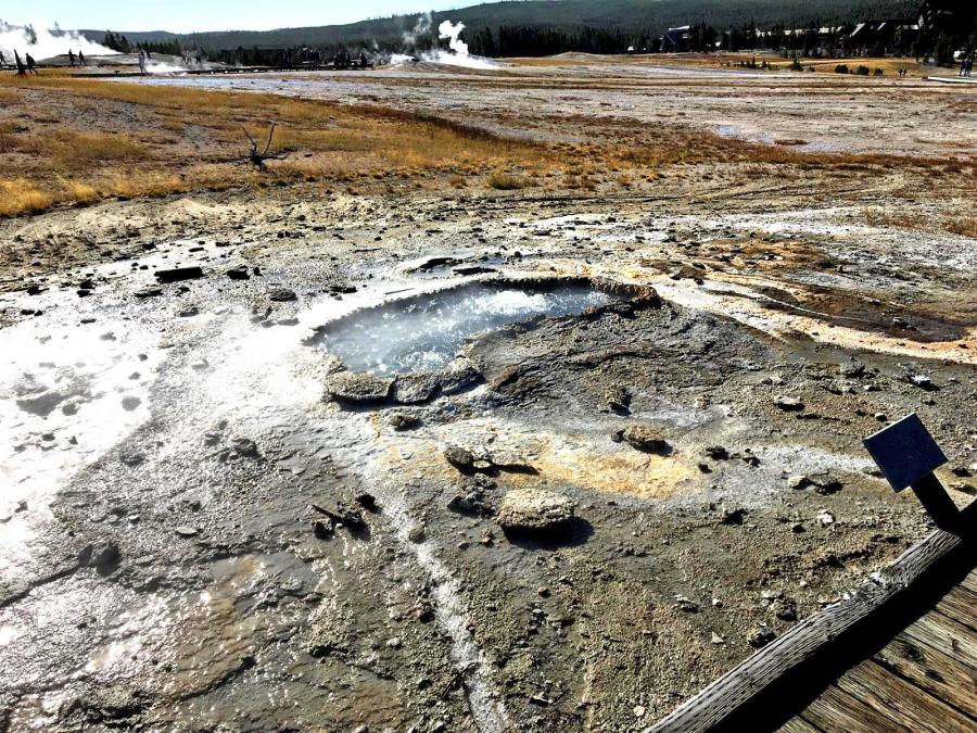
Ear Spring after an eruption of water and debris on September 15, 2018. The surrounding bacterial mats have been destroyed and large rocks are strewn around the area surrounding the spring.
The outcome of the current changes on Geyser Hill in the Upper Geyser Basin is uncertain. The two most likely possibilities are:
The area of thermally heated ground may expand and continue to cause changes in hydrothermal activity that persist for years, much like the thermal activity of 2003 in the Norris Geyser Basin. This could necessitate rerouting of the current boardwalk configuration.
A small hydrothermal explosion could occur in the area, forming a crater a few feet across and ejecting rocks and hot water up to a distance of hundreds of feet, much like that which occurred at Porkchop Geyser in the Norris Geyser Basin in 1989.
Although potential impacts to Old Faithful are unknown, Geyser Hill and Old Faithful have separate hydrothermal plumbing systems and behave independently.
Source : YVO
Photos et Vidéo : USGS
Guatemala , Santiaguito :
SPECIAL BULLETIN, Guatemala 20 September 2018 16:45 (local time)
lahars in the RIO SAN ISIDRO and TAMBOR II, volcano Santiaguito (1402-1403)
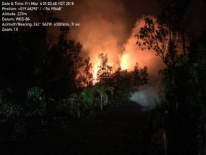
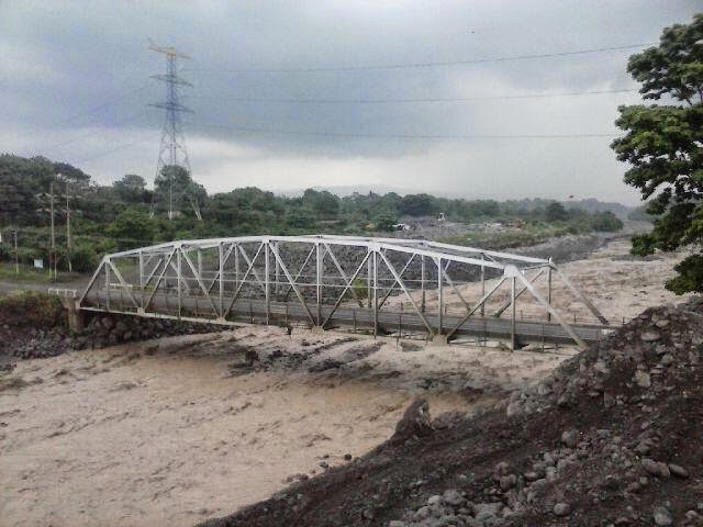
Heavy rains on the volcanic complex Santa Maria -Santiaguito, currently generates strong lahars in the San Isidro / Tambor rivers, tributaries of the Samala River, carrying blocks 1 and 2 meters in diameter, as well as the trunks and branches trees and fine material. This lahar is warm and smells of sulfur in its wake, with a width of 25 meters and a height of 2 meters. The rains at this time are abundant in the volcanic zone and there is a probability of lahars in other rivers, such as Nimá I.
For the above, INSIVUMEH recommends:
In SE-CONRED: Take the necessary precautions, especially at the height of the Castillo Armas Bridge where it is likely to occur overflows.
Activity type: Peléenne
Morphology: Complex of dacitic domes
Geographical location: 14 ° 44 ’33 ˝ Latitude N; 91 ° 34’13˝ Longitude W.
Height: 2.500msnm
Weather Conditions: Partly Cloudy
Wind: East 8 km / h
Activity:
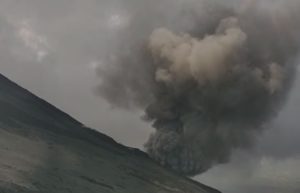
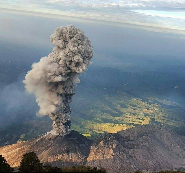
Presence of white outgassing at an approximate height of 2900 meters (9514 feet) dispersed in a southwesterly direction. Low to moderate explosions generating ash columns at 3300 meters (10827 feet) are noted, which disperse in a southwesterly direction. Slight to moderate avalanches are recorded on the south-east and north-east flanks.
Source : Insivumeh