September 11 , 2018.
Peru , Sabancaya :
An average of 17 Explosions / day was recorded. The earthquakes associated with the rise of the magma (hybrid type) remain very few and not very energetic.
Eruptive columns of gas and ash reached a maximum height of 3,500 m above the crater. The dispersion of these materials occurred within a radius of approximately 50 km, mainly in the Southwest, East and Northeast directions.
The volcanic gas (SO2) flow recorded on September 3rd a maximum value of 2380 tons / day, a value considered important.
The deformation of the surface of the volcanic building did not show any significant variations.
The MIROVA satellite system recorded 7 thermal anomalies, with values between 3 MW and 17 MW VRP (Radiated Volcano Power).
In general, eruptive activity maintains moderate levels. No significant changes are expected in the following days.
Source : IGP
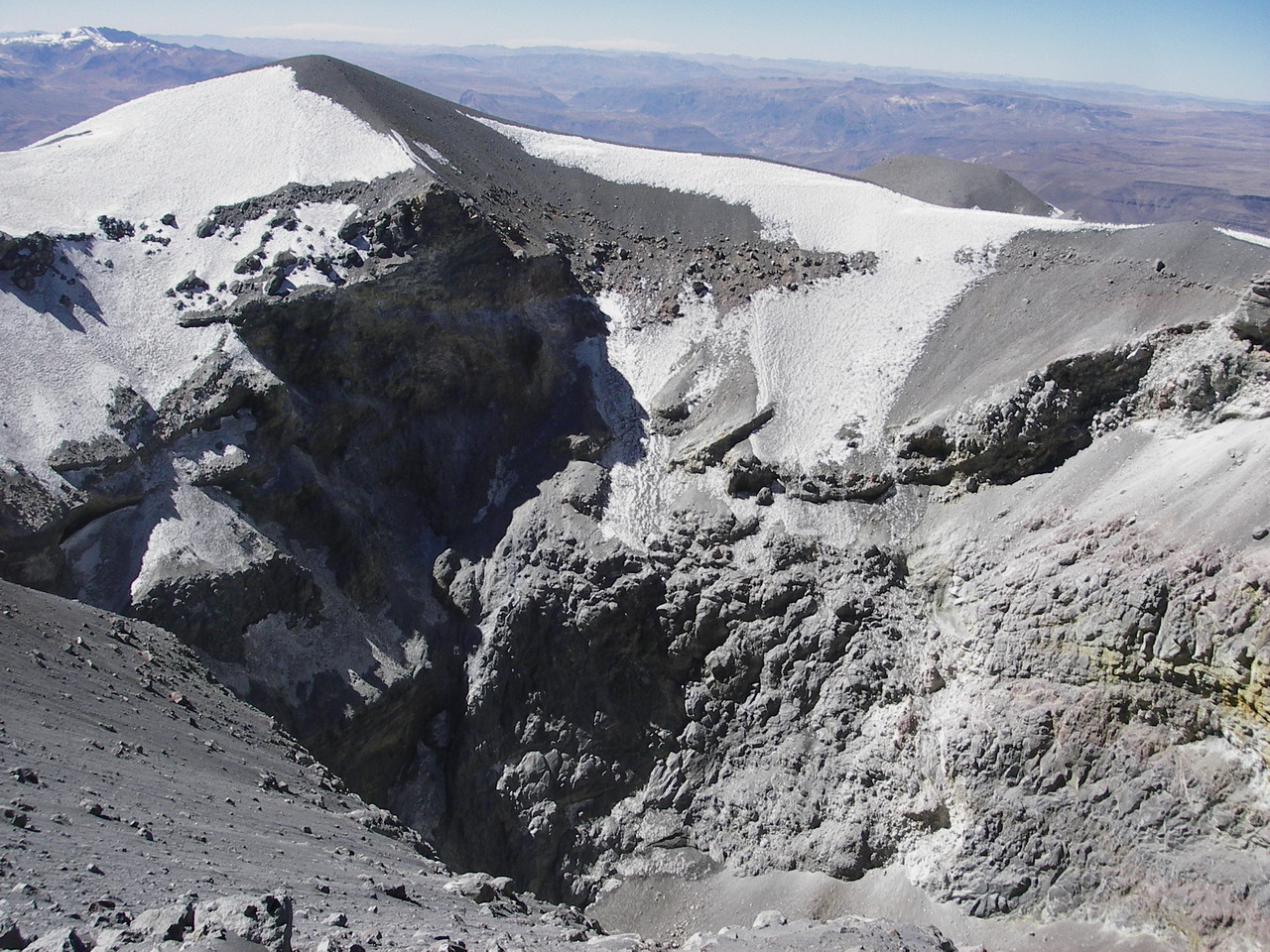
Alaska , Veniaminof :
56°11’52 » N 159°23’35 » W,
Summit Elevation 8225 ft (2507 m)
Current Volcano Alert Level: WATCH
Current Aviation Color Code: ORANGE
High-resolution satellite imagery acquired yesterday shows a lava flow roughly 800 meters (0.5 miles) long on the south flank of Veniaminof volcano’s summit cone. Eruptive activity was corroborated by witnesses aboard the Alaska State Ferry Tustumena, who observed lava fountaining and an active lava flow when passing by Veniaminof early this morning. Elevated seismic activity, nighttime incandescence in webcam images, and elevated surface temperatures in thermal satellite data have not changed significantly over the past several days, suggesting that this eruptive activity may have been ongoing throughout that time.
Landsat 8 image of Veniaminof volcano, September 9, 2018. A small lava flow, about 500m long, is visible on the south flank of the intracaldera cone. Also note a triangular-shaped patch of thin ash depositson the snow south of the cone. Small lava flows like this one were also erupted in 1983-84, 1993, and 2013.
Veniaminof Volcano is monitored with a local real-time seismic network, which will typically allow AVO to detect changes in unrest that may lead to an explosive eruption. Rapid detection of an ash-producing eruption would be accomplished using a combination of seismic, infrasound, lightning, and satellite data.
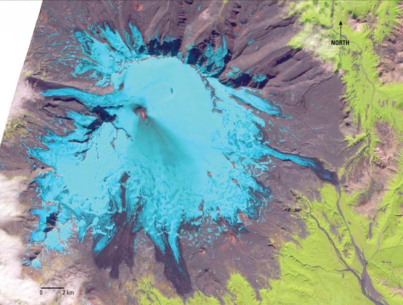
From Miller and others (1998) : »Mount Veniaminof is a broad central mountain, 35 km wide at the base, truncated by a spectacular steep-walled summit caldera 8×11 km in diameter. The caldera is filled by an ice field that ranges in elevation from approximately 1750 to 2000 m; ice obscures the south rim of the caldera and covers 220 square km of the south flank of the volcano. Alpine glaciers descend from the caldera through gaps on the west and north sides of the rim and other alpine glaciers occupy valleys on the north-, east-, and west-facing slopes of the mountain. In the western part of the caldera, an active intracaldera cone with a small summit crater has an elevation of 2156 m, approximately 330 m above the surrounding ice field.
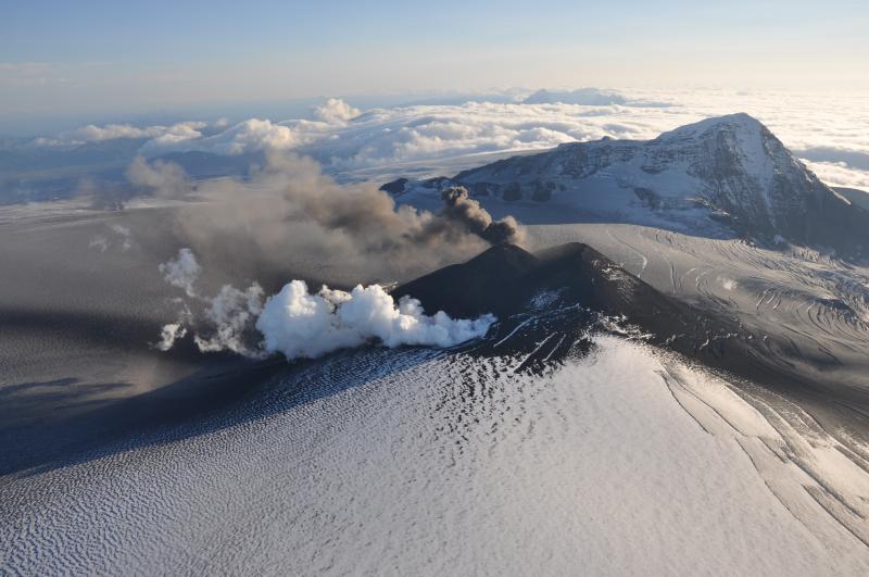
Aerial view from the north of the erupting intracaldera cinder cone of Veniaminof volcano. Two lava flows emerge high up on the east flank of the cone and advance into a melt-pit (white steam plume) while Strombolian explosions occur at the summit (dark, ashy plume).
The rim of a larger but more subdued intracaldera cone protrudes just above the ice surface in the northern part of the caldera; based on limited exposure and physiographic features, it may have a summit crater as much as 2.5 km in diameter.
« Andesitic and dacitic ash-flow tuffs from the caldera-forming eruption occur in many of the valleys on the north slope of the volcano and are found as far away as 50 km from the caldera rim on both the Bering Sea and Pacific Ocean coasts.
« A northwest-trending belt of post-caldera cinder and scoria cones, including the two intracaldera cones, extends from near the Bering Sea coast approximately 55 km across the main volcanic edifice and the Aleutian Range divide, well down the Pacific slope.
Source : AVO
Photo : Waythomas, chris ( 2018 ) , McGimsey, R. G. ( 2013 )
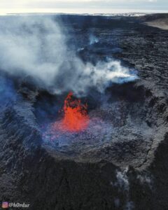
Chile , Villarica :
A total of 6661 seismic events have been recorded, of which 6499 have been classified as long-period type (LP) earthquakes, in relation to the fluid dynamics inside the volcano, with maximum reduced displacement values of 24 cm2. In addition, 162 seismic events of the volcano-tectonic (VT) type, associated with rock fracturing, were recorded. The event with the greatest energy had a local magnitude of 2.5, and was located 4.4 km east of the active crater and at a depth of 4 km.
The series of volcanic tremor, seismic series also associated with the dynamics of the fluids inside the volcano during the period considered was maintained with reduced displacement values maximum of 3 cm2. On the other hand, the dominant frequencies are maintained between 1.0 and 2.1 Hz, sometimes with the presence of frequencies around 5 Hz.
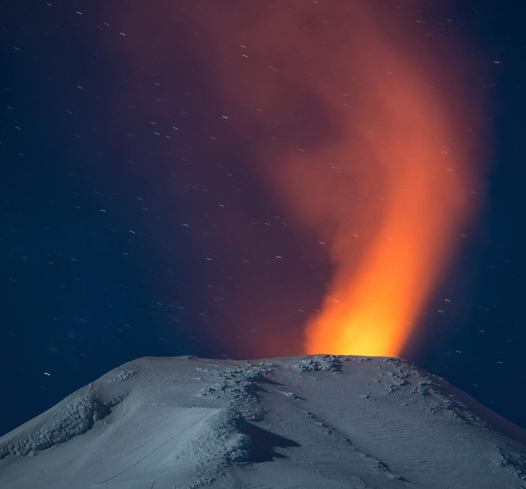
The images recorded with the IP cameras installed near the volcano, when the weather conditions permitted, showed degassing of predominantly whitish color; this one did not exceed 600 m of height. In addition, a night glow is recorded, when the weather conditions allowed to observe it.
The infrasound sensor recorded explosions associated with the surface activity of the lava lake hosted in the main crater, with pressures greater than 1.8 pascal. (value considered low).
According to data provided by five (5) GNSS stations and two (2) electronic inclinometers, no significant changes were detected due to changes in the internal activity of the volcano during the period.
No emissions of sulfur dioxide (SO2) to the atmosphere in the volcano area have been reported, according to data published by the Ozone Monitoring Instrument (OMI) Sulfur Dioxide Group (http: / /so2.gsfc.nasa.gov/) and the National Environmental Satellite Information and Data Service (NESDIS) (http://satepsanoine.nesdis.noaa.gov).
During the period 11 thermal warnings were reported on the volcano, with a maximum of 59MW observed volcanic radiative power (VRP) as of 02 August, which is considered moderate, according to the data processed by Observation of the volcano. volcanic activity (Mirova) (http://www.mirovaweb.it/).
During this period, the activity of the lava lake increased, with a more superficial level, however always maintaining a state of equilibrium. In the margins of this activity, there is always a great possibility of occurrence of weak explosions that can project incandescent materials in the vicinity of the crater.
As a result, the alert level is maintained at:
GREEN LEVEL: Active volcano with stable behavior – No immediate risk – Time for possible eruption: MONTH / YEARS.
Observation: It is recommended to apply precautionary access restrictions to an area close to the crater with a radius of 500 m.
Source :Sernageomin
Photo : Martini Fotografia. ( Sherine France)
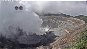
Costa Rica , Turrialba :
Report on the activity of Turrialba volcano
September 10, 2018.
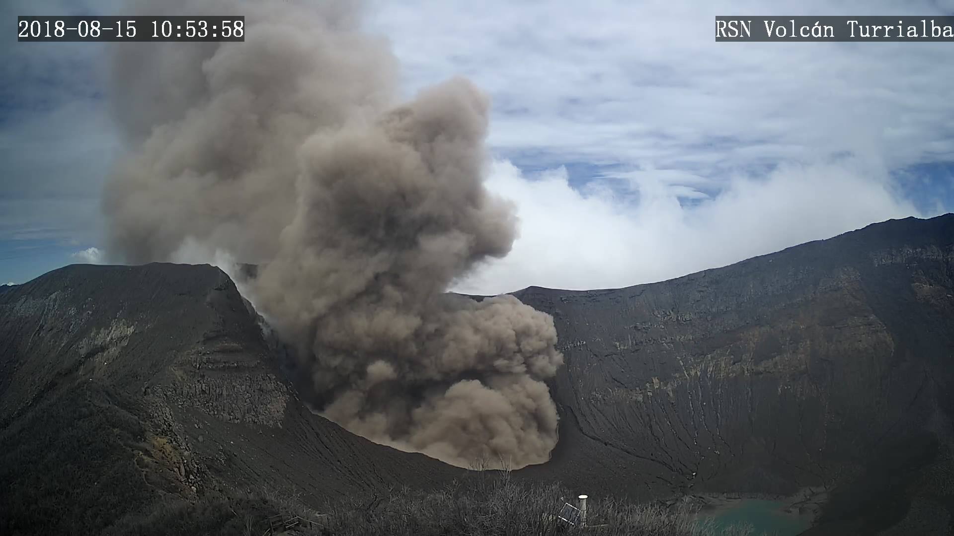
Since September 10, 2018 at 12:10 local time, an eruption is recorded on the Turrialba volcano, with a column that rises 300 meters above the crater height and 3640 m. (meters above sea level) (11939.2 ft).
Duration of the activity: In progress.
The winds blow towards the North-West.
Reported ash falls: No reported ash drop
Sulfur odor reported: No sulfur odor reported
Comments: Diluted ashes are detected in the plume. It is a passive activity.
Source : Ovsicori.
Photo : RSN