May 04 , 2024.
Iceland , Reykjanes Peninsula :
Land continues to rise at Svartsengi. Increased likelihood of a new volcanic eruption
Updated 2. May at 18:00 UTC
Land rise continues at Svartsengi. Pressure continues to build up within the magma chamber.
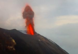
Lava flow from the crater, which has been decreasing in recent days, continues.

Measurements and simulations indicate that there is significant uncertainty about the future. The likelihood of a new volcanic eruption and/or an increase in the intensity of the eruption at the Sundhnúkur crater row is growing.
There is a risk that lava may breach the eastern defenses of Grindavík if the eruption’s strength increases again.
The hazard assessment remains unchanged.
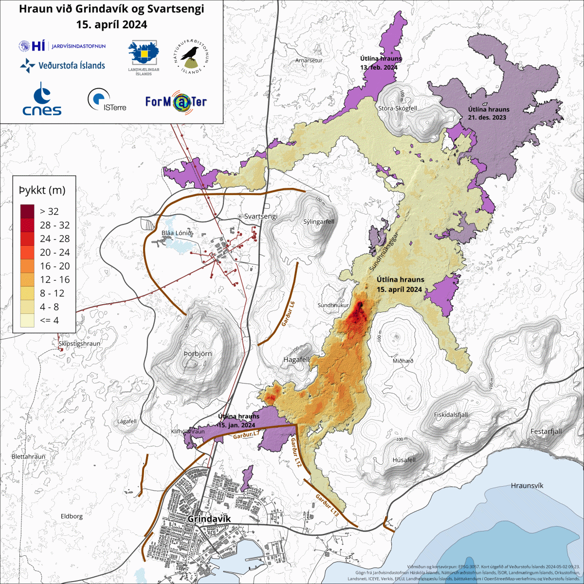
Land deformation continues to be measured at Svartsengi, and the rate of uplift has remained stable in recent weeks (see image below). Earlier in the week, there were indications that the rate of land rise might have slowed in the preceding days. However, measurements since then reveal that the rate has remained steady in the context of the past few weeks. Pressure continues to increase within the magma chamber, and there is a risk that the magma chamber beneath Svartsengi will feed a new volcanic eruption.

The graph shows ground movement in the vertical component at the GPS station SKSH in Svartsengi. The measurements indicate that the rate of land deformation has remained steady since the beginning of April. The blue line represents the timing of the magma intrusion, which did not culminate in an eruption, while the red lines represent diking events that resulted in an eruption. The second red line shows the onset of the ongoing volcanic eruption.
Seismic activity has increased along the Sundhnúkur crater row in recent days. These earthquakes are small, likely representing a release of stress within and around the increasingly pressurized magma chamber beneath Svartsengi.
Lava flow from the active crater is significantly lower than it was three weeks ago, and the ccurrent flow rate is measured to be relatively small. However, an eventual increase in flow rate must be considered despite the currently minimal lava flow.
Lava from the crater has been accumulating near Grindavík’s eastern defense wall in recent weeks (L12 on the image above). If the intensity of the eruption increases or new fissures open south of the current eruption site, it is expected that the lava flow will advance towards the eastern defenses of Grindavík. On Saturday, April 27th, small lava flows crossed the defenses east of Grindavík. If the power of the eruption increases again, there is a risk that such occurrences will become more frequent.
These are the most likely two scenarios regarding the continuation of activity at the Sundhnúkur crater row:
New volcanic fissures could open in the area between Stóra-Skógafell and Hagafell, and/or the current eruption site could expand due to a sudden increase in lava flow, which may be comparable to the initial phases of the last volcanic eruption in the area. This could occur with very little or no warning.
It is also possible that the flow of magma from the magma chamber beneath Svartsengi into the active vent at the Sundhnúkur crater row may increase steadily until there is equilibrium between the inflow of magma into the chamber and the outflow onto the surface.
Precursory signals of a new volcanic eruption would resemble previous events, with sudden and intense seismic activity within and around the magma chamber and land deformation in Svartsengi.
The hazard assessment by the Icelandic Meteorological Office remains unchanged and is valid until May 7th, unless the situation changes.
Source : IMO
Photos : Hörður Kristleifsson , IMO.
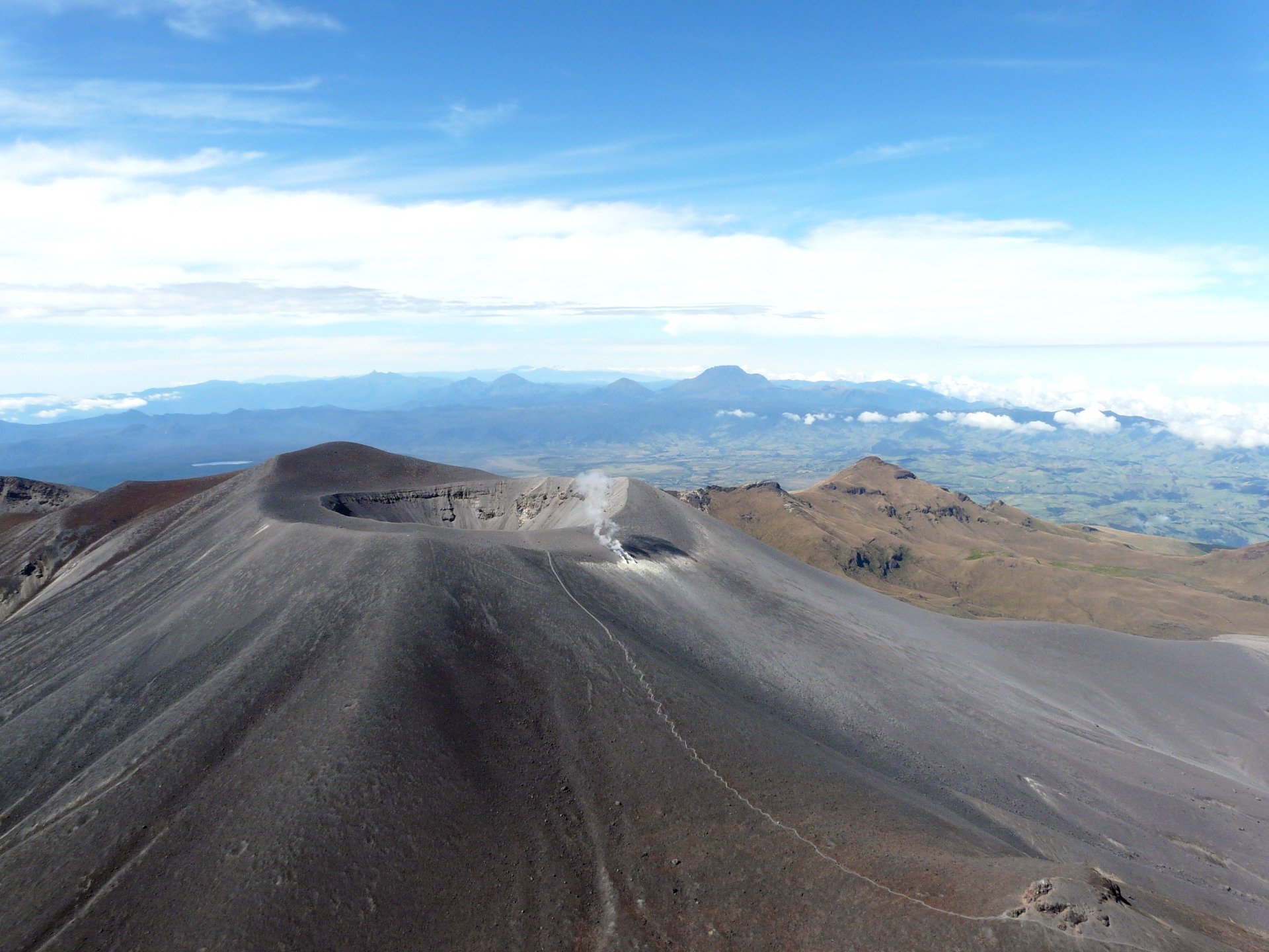
Colombia , Puracé :
Popayan, May 3, 2024, 4:45 p.m.
Regarding the monitoring of the activity of the PURACE VOLCANO, the MINISTRY OF MINES AND ENERGY, through the COLOMBIAN GEOLOGICAL SERVICE (SGC), reports that:
The alert status of VOLCANO PURACE changes to ORANGE: volcano with significant changes in the monitored parameters.
Since April 29, there has been a sudden increase in the seismic activity of this volcano, in terms of the number of events and the energy released, both by earthquakes associated with the fracturing of rocks and by those associated to the activity of fluids inside the volcano. This was reported in two extraordinary bulletins published on April 30 and May 2, 2024. Likewise, the slow deformation process begun in April 2022 between the Puracé and Curiquinga volcanoes continues to be recorded. Increased gas emissions continue to be observed across the lateral fumarole north of and within the crater rim, with elevated levels of carbon dioxide (CO2) concentration and dioxide flux sulfur (SO2).
As has been reported from time to time, for months the activity of the Puracé volcano has been gradually increasing and reaching levels considered significant, well above those that characterize a volcano in a state of yellow alert. The seismic activity, the deformation recorded on the surface of the volcano, the physicochemical parameters of the waters, the characteristics of the gases and the temperature presented significant changes. As of the writing of this bulletin, volcanic activity continues to evolve at higher levels than previously recorded, and therefore the change in alert status is determined.
Although the orange alert state is maintained, it is possible that there will be temporary fluctuations in the activity levels of the volcano, that is, at certain times its activity may decrease by compared to previous days or weeks, but this does not necessarily imply that the volcano has returned to a stable state of activity. To return to a minor alert state (yellow), a reasonable period of time is required during which all monitored parameters are evaluated and trends that may indicate greater stability are determined.
It is recommended that the community in general does not approach the crater area, because with the current level of activity of the Puracé volcano there is a great risk of being affected by gas or ash emissions that could occur suddenly.
While on ORANGE alert, the volcano may exhibit moderate to high increases in seismicity, which may be associated with fluid dynamics or rock fractures within the volcano, considerable surface deformation, significant changes in levels (drastic increase or decrease in the frequency of emissions of SO2 or other magmatic gases), increasing heights of the water vapor column and gases. The superficial manifestations that some of these phenomena can generate are: frequent emissions of ash (minor eruptions) whose volume does not significantly affect daily life, explosions or incandescence, significant thermal anomalies, noise, felt earthquakes, strong and irritating odors in areas near the volcano, precipitation of elemental sulfur near the volcanic edifice, release of magmatic gases in a significant way which can cause the death of small animals near the volcano and cracks in the ground. The elevation and destruction of domes with limited impact range, ballistic projectiles, low volume lahars or pyroclastic density currents limited to the proximal part of the volcanic edifice may also occur.
Source et photo : SGC.
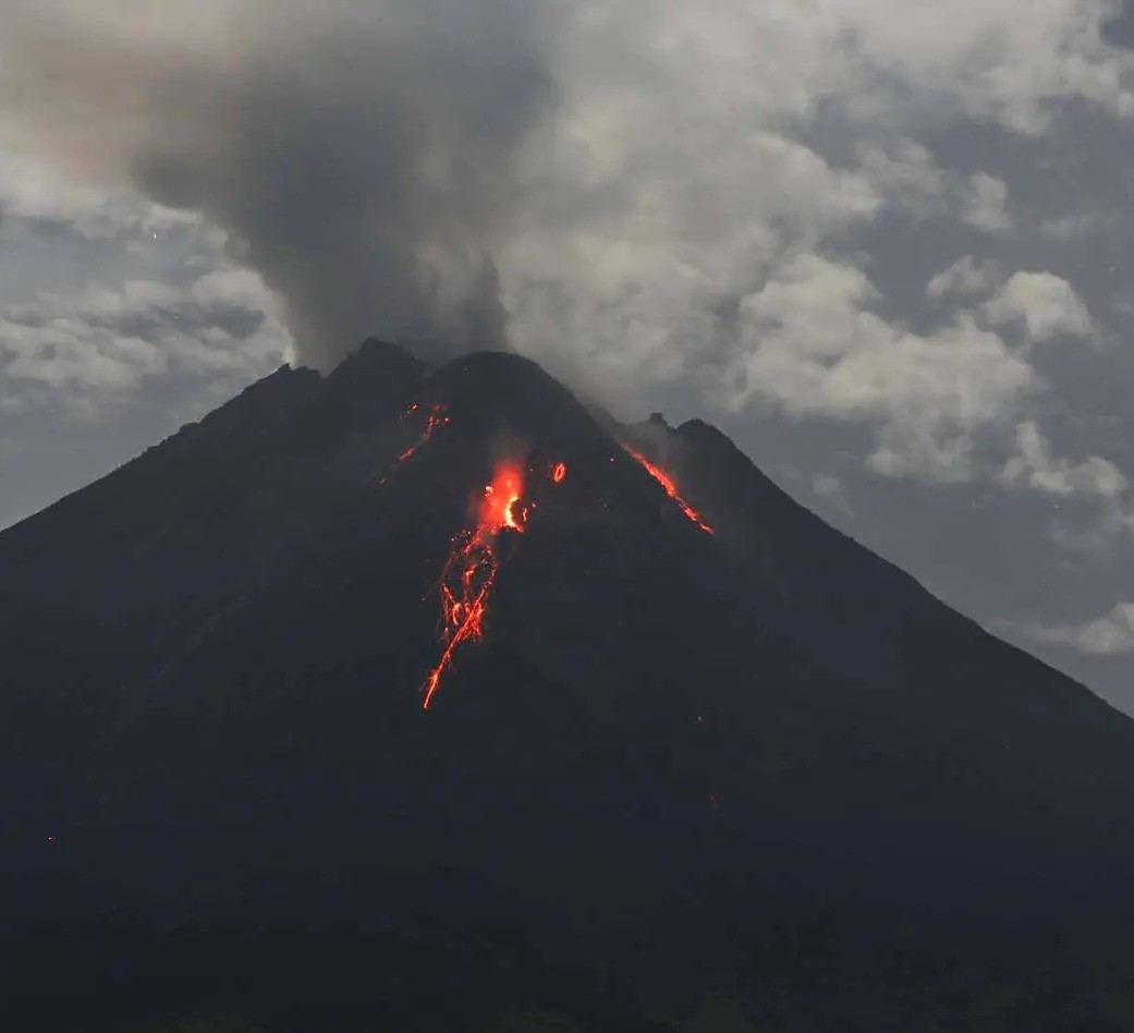
Indonesia , Merapi :
Mount Merapi activity report from April 26 to May 2, 2024. Published on May 4, 2024.
OBSERVATION RESULT
Visual
The weather around Mount Merapi is generally clear in the morning and evening, while it is foggy from noon to evening. White smoke, light to thick, low to moderate pressure and 250 m high was observed from the observation post of Mount Merapi Babadan on April 26, 2024 at 05:39 WIB. This week, lava avalanches were observed 113 times towards the South-West (upstream of the Bebeng River) up to a maximum of 2,000 m. The sound of avalanches was heard 3 times from the Babadan post with low to moderate intensity. It was observed that the morphology of the southwest dome had changed due to the growth activity of lava avalanches. The highest hot spot was observed at 247.4°C, higher than the previous measurement temperature. The morphology of the median dome is relatively constant. The highest hot spot was observed at 215.2°C, which was higher than the previous measurement temperature. Based on the analysis of aerial photos from April 24, 2024, the volume of the southwest dome was measured at 2,171,300 m3 and that of the central dome at 2,358,200 m3.
Seismicity
This week, Mount Merapi seismicity recorded:
10 shallow volcanic earthquakes (VTB),
61 multi-phase (MP) earthquakes,
1 low frequency earthquake (LF),
463 avalanche earthquake (RF),
12 tectonic earthquakes (TT).
The intensity of earthquakes this week was lower than last week.
Deformation
The deformation of Mount Merapi monitored by EDM this week shows a shortening rate of 0.2 cm/day.
Rain and lahars
This week there was rain at Mount Merapi lookout post with a rain intensity of 19 mm/hour for 56 minutes at Kaliurang lookout post on April 26, 2024. No additional flow or lahar was reported in the rivers that have their source on Mount Merapi.
Conclusion
Based on the results of visual and instrumental observations, it was concluded that: The volcanic activity of Mount Merapi is still quite high in the form of effusive eruptive activity. The activity status is set to the “SIAGA” level
Source : BPPTKG
Photo : Andi Volcanist .
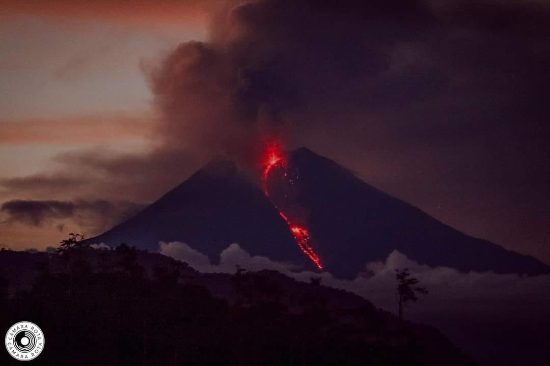
Ecuador , Sangay :
DAILY REPORT ON THE STATE OF THE SANGAY VOLCANO, Friday May 3, 2024.
Information Geophysical Institute – EPN.
Surface activity level: High, Surface trend: No change
Internal activity level: High, Internal trend: No change
Seismicity: From May 2, 2024, 11:00 a.m. to May 3, 2024, 11:00 a.m.:
The number of seismic events recorded at the reference station over the past 24 hours is shown below. The level of seismic activity of the volcano remains high.
Explosion Event (EXP): 486
Precipitation/Lahars:
Yesterday afternoon, at the time of writing this report, rains were recorded in the volcano area without generating mudflows and debris. *In the event of heavy rains, these could remobilize the accumulated materials, generating mud and debris flows which would descend the sides of the volcano and flow into adjacent rivers.*
Emissions/ash column:
Over the last 24 hours, thanks to the network of surveillance cameras, several gas and ash emissions have been recorded with heights between 300 and 1,700 meters above the level of the crater, in the southwest direction. In connection with these emissions, the Washington VAAC published four reports with heights of 900 and 1,200 meters above the level of the crater, in the West and Southwest directions.
Gas:
The MOUNTS satellite system reported 63.8 tons of sulfur dioxide (SO2) measured on 05/02/2024 at 1:59 p.m. TL.
Other monitoring parameters:
The MIROVA-VIIRS satellite system recorded 2 thermal anomalies, the MIROVA-MODIS system recorded 1 thermal anomaly and the FIRMS satellite system recorded 11 thermal anomalies, over the last 24 hours.
Observation:
During the night of yesterday and early today, several episodes of incandescence and descent of incandescent material were recorded in the South-East ravine up to 2000 meters below the level of the crater. At the time of closing this report, the volcano remains completely cloudy
Alert level: yellow
Source : IGEPN.
Photo : Camara Rota
Costa Rica , Rincon de la Vieja / Poas :
Daily report on the state of volcanoes. Date: May 3, 2024. Updated at: 8:21:00 p.m.
Rincón de la Vieja Volcano
Latitude: 10.83
Longitude:-85.324
Altitude: 1,916 meters

Activity observed:
Over the past 24 hours, no eruptions or ash emissions have been recorded. An intense volcanic tremor signal continues to be recorded with a frequency band between 0.7 and 4 Hz. The tremor is accompanied by frequent low-frequency long-period LP type events. A vigorous plume rich in water vapor, gas and aerosols is observed using webcams and disperses mainly towards the North-West. Data from the DOAS gas detection system gives an estimated average flow of 301 +/-89 tonnes of SO2 per day for this week, a value similar to those generally observed since the end of 2022. The SENTINEL satellite detected today May 3 2022. 2024 a mass of 40 tonnes of SO2.
Environmental conditions:
The wind is mainly directed towards the North-East (Windy.com).
Activity Level: Caution (3)
Poas Volcano
Latitude: 10.2
Longitude: -84,233
Altitude: 2,687 meters
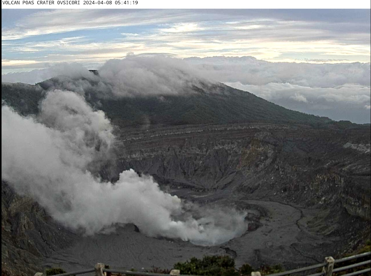
Activity observed:
The OVSICORI-UNA seismograph network records intermittent seismic tremor signals with predominant frequencies around 2.5 Hz. The fumaroles at the bottom of the crater emit plumes rich in water vapor, gas and aerosols (fine particles of ashes and minerals).
The SO2 gas concentration recorded by ExpoGAS at El Mirador para Visitantes today recorded less than 1 part per million. On the other hand, the MultiGAS system located on the western edge of the crater recorded gas ratios similar to previous weeks: SO2/CO2=1.25; H2S/SO2=0.6 and SO2 concentrations fluctuating between 0.3 and 12 pppm. The SENTINEL satellite detected a mass of 55 tons of SO2 on May 2, 2024, and today, May 3, 20 tons of SO2.
Residents of Alajuela, Heredia, San José and Cartago reported, between the night of May 2 and the morning of May 3, the perception of a peculiar smell of sulfur. During this period, the OVSICORI-UNA volcanic gas and aerosol monitoring station in Coronado detected a slight increase in SO2 in the ambient air, of 2.5 parts per billion. This slight increase in SO2 at Coronado suggests that the Poás plume dispersed between the night of May 2 and the early morning of May 3 in a west-southwest direction, towards the central Pacific-Herradura.
Environmental conditions:
The predominant wind direction at the summit of Poás is towards the South-West at the time of writing this report.
Activity Level: Warning (2)
Source : Ovsicori
Photos : Federico Chavarría-Kopper – Ovsicori , Ovsicori ( archive).