September 01 , 2018.
Colombia , Nevado Del Ruiz :
Subject: Activity bulletin of the Nevado del Ruiz volcano.
The level of activity continues at the level: Yellow activity level or (III): changes in the behavior of volcanic activity.
With regard to monitoring the activity of the Nevado del Ruiz volcano, the COLOMBIAN GEOLOGICAL SERVICE informs that:
During the last week, the seismicity caused by the fracturing of the rocks that make up the volcano showed a slight decrease in the number of earthquakes and released seismic energy, compared to the previous week. The earthquakes were located mainly in the north-east, south-east and south of the volcano and, to a lesser extent, in the Arenas crater, at depths between 0.6 and 6.0 km. The maximum magnitude recorded during the week was 1.1 ML (Local Magnitude) for the 21 August local earthquake at 05.27 (local time), located 2.2 km south-southeast of Arenas Crater. at a depth of 3.4 km.
Seismicity related to fluid dynamics within volcanic ducts showed a slight increase in the number of earthquakes and released seismic energy compared to the previous week. This type of seismic activity has been characterized by the appearance of earthquakes with variable energy levels, long-period type (LP), very long period (VLP), pulses of volcanic tremors and short periods of continuous volcanic tremor. The earthquakes were mainly in the crater Arenas and its surroundings. Some of these seismic signals have been associated with emissions of gas and ash into the atmosphere, as confirmed by images captured by cameras in the volcano area and by staff at Los Nevados National Park (PNNN). ) and the inhabitants of the region. These ash emissions have been reported to civil aviation through VONA notifications (Aviation Volcano Observatory Notice).
Volcanic deformations measured from electronic inclinometers, Global Navigation Satellite System (GNSS) stations and radar images show until now a stability behavior without recording any important process of deformation of the volcanic structure.
The volcano continues to emit water vapor and gases into the atmosphere, among which is the sulfur dioxide (SO2), as evidenced by the values obtained by the SCANDOAS stations installed in the volcanic region and the satellite image analysis. In tracking information provided by NASA’s FIRMS portal, a low-energy thermal anomaly was recorded during this week.
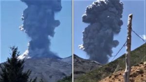
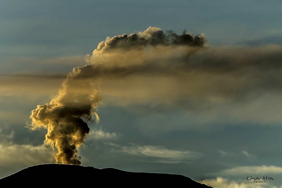
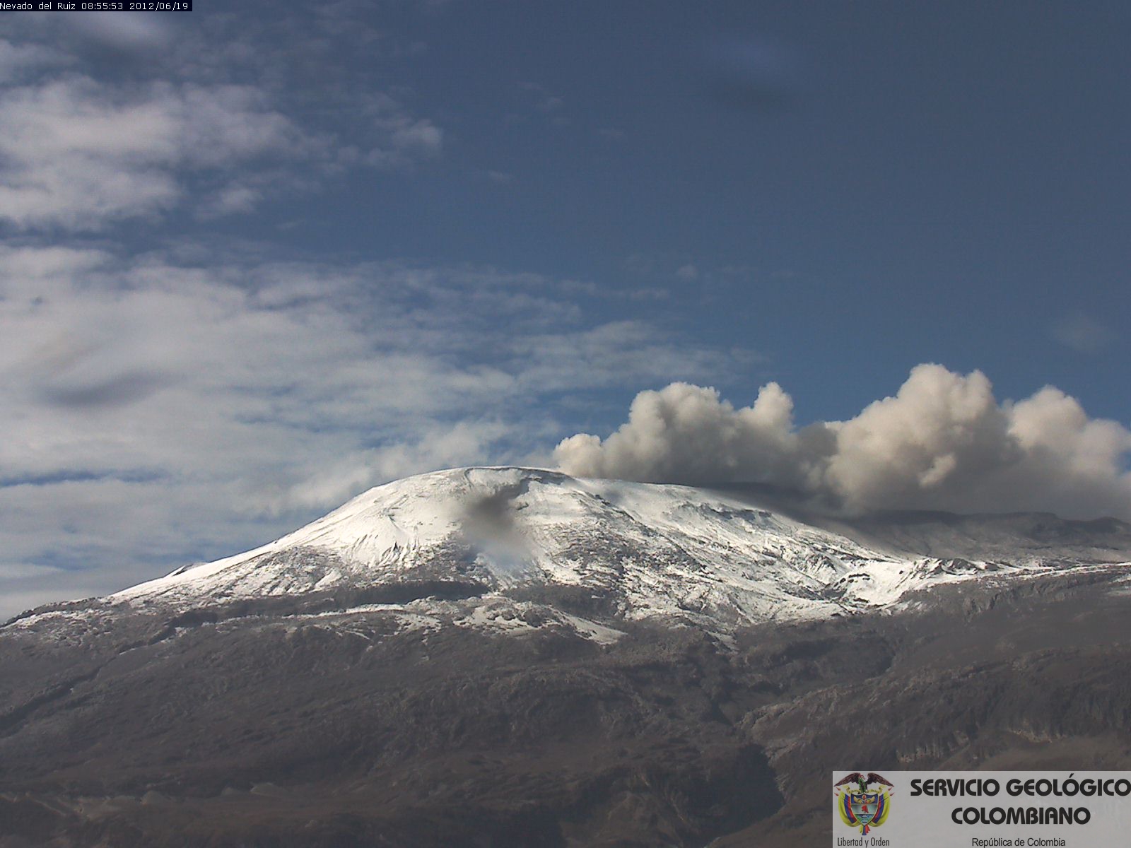
The column of gas and steam reached a maximum height of 1000 meters measured at the top of the volcano on 25 August. The direction of dispersal of the column was governed by the direction of the wind in the area which, during the week, prevailed to the northwest relative to the crater Arenas.
The Nevado del Ruiz volcano remains at the level of yellow activity.
Source : SGC
Photos : César Rios , SGC ( 2012)
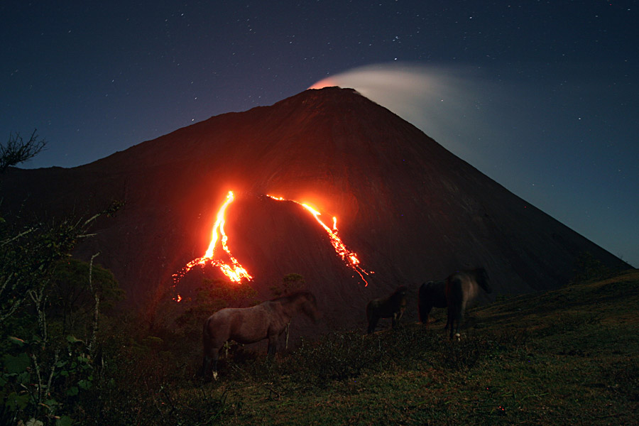
Guatemala , Pacaya :
Type of activity: Strombolian
Morphology: Stratovolcano Composite
Location: 14 ° 22’50˝ Latitude N; 90 ° 36’00˝ Longitude W.
Height: 2,552msnm.
Weather Conditions: Partly Cloudy
Wind: North
Precipitation: 2.8 mm
Activity:
Presence of weak to moderate outgassing of white and sometimes blue at an approximate height of 200 meters above the southward dispersing crater. Strombolian explosions raise low-level material above the crater. The lava flows towards Cerro Chino on the north and northwest flanks. It is possible to perceive the sound of avalanches and small explosions mainly during the night. The seismic station records the internal tremors associated with degassing and explosions generated in the area.
Source : Insivumeh
Photo : Inconnu.
Vanuatu , Ambrym :
16.25°S, 168.12°E
Elevation 1334 m
Ambrym volcano is continuing in the major unrest state. The Volcanic Alert Level remains at Level 2 .
The volcanic unrest continues at Ambrym. The volcanic activity is likely to continue at similar levels, consistent with Volcanic Alert Level 2. The Danger Zone for life safety is limited at the Permanent Exclusion Zone at Benbow which is about 1 km around Benbow crater and the Danger Zone A at Marum (including Maben-Mbwelesu, Niri-Mbwelesu and Mbwelesu) which is about 2.7 km around Marum crater.
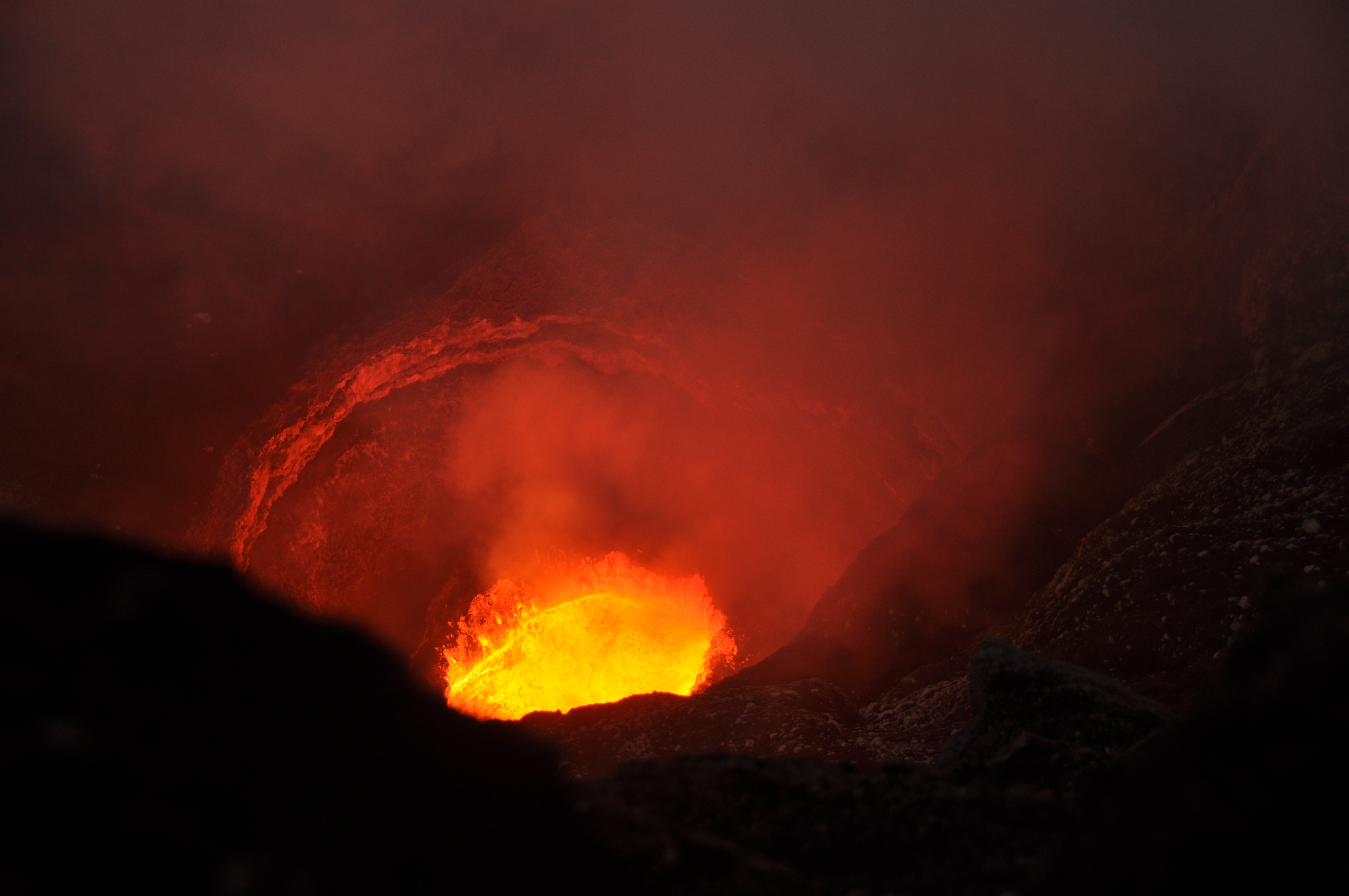
Observations and the analysis of seismic data in August 2018 confirm a continuous volcanic activity in the major unrest state and is confined in Benbow and Marum craters. The activity consists of ongoing active lava lake inside the active vents inducing sustained substantial degassing and emission of steam cloud. Gas will be continue to be smelt while approaching the volcanic area and craters.
On 22 August the Vanuatu Meteorology and Geo-hazards Department reported that the lava lakes in Ambrym’s Benbow and Marum craters continued to be active, and produced sustained and substantial gas-and-steam emissions. The Alert Level remained at 2 (on a scale of 0-5); the report reminded the public to stay outside of the Permanent Danger Zone defined as a 1-km radius from Benbow Crater and a 2.7-km radius from Marum Crater.
Source : Geohazard , GVP
Photo : LCDV /Georges Vitton
Mexico , Popocatepetl :
August 31, 11:20 am (August 31, 1620 GMT)
In the last 24 hours, through monitoring systems of the Popocatepetl volcano, 144 low intensity exhalations accompanied by water vapor and gas have been identified. In addition, 36 explosions were recorded, 31 of which were recorded from 15:00 to 20:30 yesterday (30/08). These events emitted volcanic gases and small amounts of ash. In addition, today three volcano-tectonic earthquakes, at 04:39, 06:06 and 07:06 h, with a magnitude of 1.6, 1.7 and 1.4, respectively, and 10 minutes of harmonic tremor of low amplitude were detected.
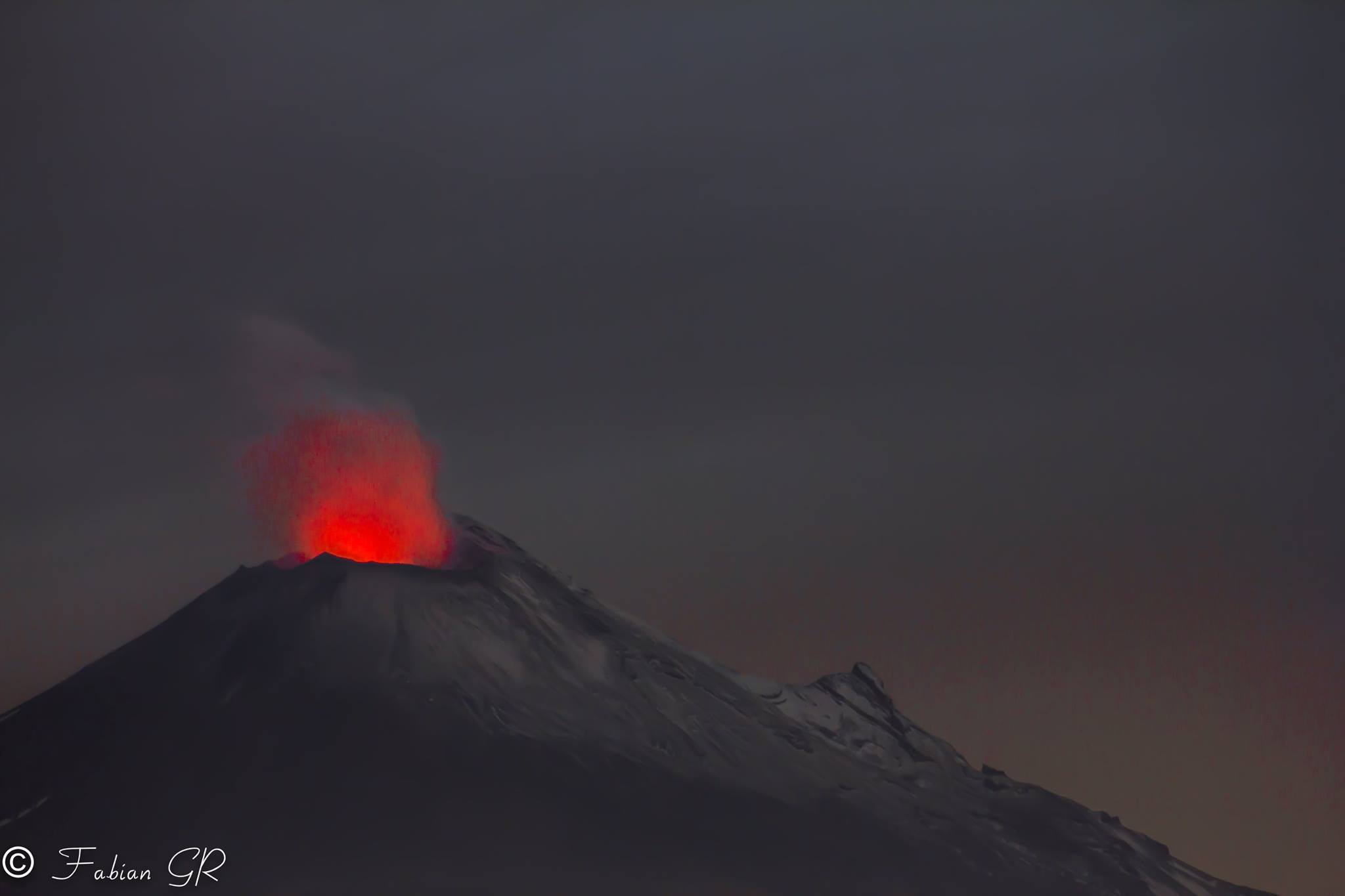
During the night, intense incandescence could be observed on the crater.
At the time of this report, there is no visibility towards the volcano. However, in the early hours of the morning, the continuous emission of volcanic gases to the west could be observed.
CENAPRED asked not to approach the volcano and in particular of the crater, the risk of falling of projectiles is important and in case of heavy rain to remain far from the bottom of the ravines because of the danger of landslides and mudslides .
The warning light of the Popocatepetl volcano is located at Amarillo Phase 2.
Source : Cenapred
Photo : Fabian GR