July 16 , 2018.
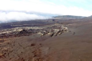
La Réunion , Piton de la Fournaise :
Activity Bulletin from Sunday, July 15, 2018 at 3:00 pm (local time)
The seismic activity under the summit of Piton de la Fournaise is decreasing, so have been recorded since the end of the eruption:
– 14 superficial volcano-tectonic earthquakes (<2 km deep) on July 13 (from 10 pm local time),
– 50 superficial volcano-tectonic earthquakes (<2 km deep) on July 14,
– 1 superficial volcano-tectonic earthquake (<2 km deep) on July 15 (until 3 pm local time).
No significant deformities were observed today.
Alert level: Backup.
Bulletin of Monday, July 16, 2018 at 7:00 am (local time) – earthquake felt
On Monday, July 16, 2018, 06:02 (local time – 02H: 02 UT), an earthquake was felt by residents of the island, mainly in the north.
This earthquake was recorded by the seismometers of the Volcanological Observatory of Piton de la Fournaise. The first analyzes of this earthquake made it possible to locate it, 10 km below sea level in the sector of the Ecrite rock, 7 km southwest of Sainte-Clotilde. Its magnitude was measured at 2.1 on the Richter scale. OVPF staff are working on refining the location calculations for this event. Also location and intensity information could change marginally.
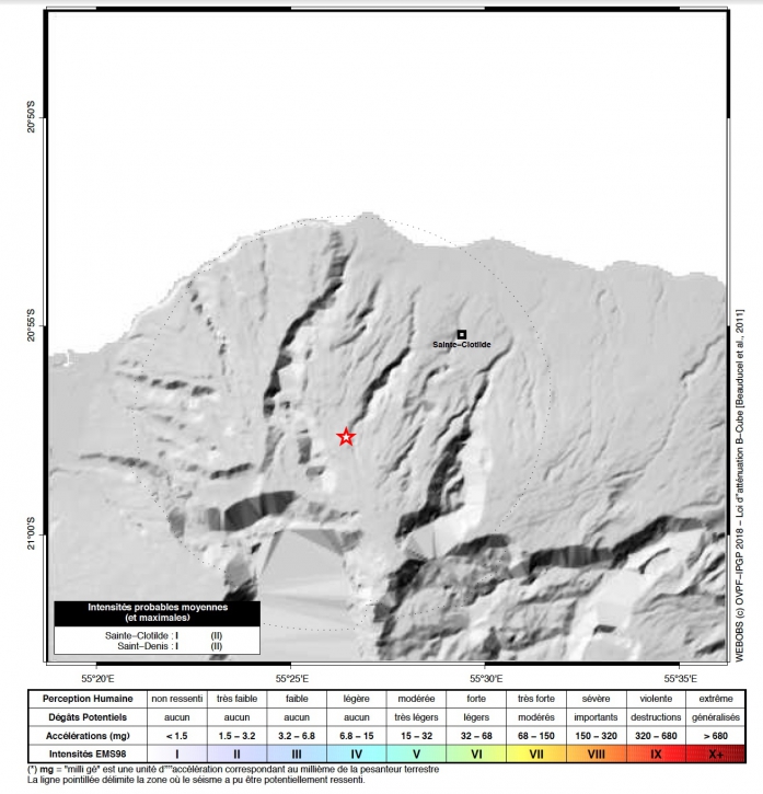
Map of the earthquake felt in Réunion on July 16, 2018 at 06:02 (local time). (© OVPF / IPGP)
This type of event, felt by the population is recorded several times a year. This event is isolated and is of tectonic origin. This earthquake was followed by a second, at 06:04 (local time, 02:04 UT) located in the area of Mafate, not felt by the population.
Source : OVPF.
Photo : Obs Fournaise
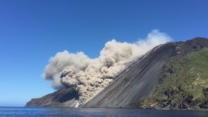
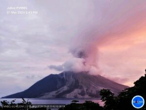
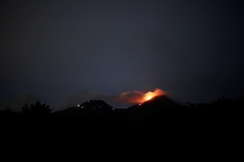
Indonesia , Anak Krakatau :
VOLCANO OBSERVATORY NOTICE FOR AVIATION – VONA
Issued: July 15 , 2018
Volcano: Anak Krakatau (262000)
Current Aviation Colour Code: ORANGE
Previous Aviation Colour Code: orange
Source: Anak Krakatau Volcano Observatory
Notice Number: 2018KRA16
Volcano Location: S 06 deg 06 min 07 sec E 105 deg 25 min 23 sec
Area: Lampung, Indonesia
Summit Elevation: 976 FT (305 M)
Volcanic Activity Summary:
Eruption with volcanic ash cloud at 00h22 UTC (17h22 Local). Eruption and ash continuing.
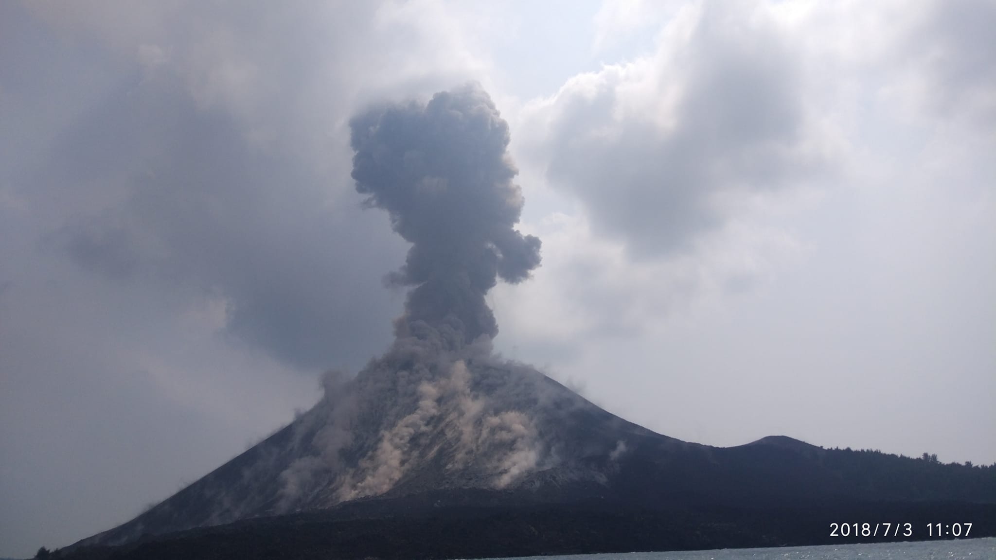
Volcanic Cloud Height:
Best estimate of ash-cloud top is around 3216 FT (1005 M) above sea level, may be higher than what can be observed clearly. Source of height data: ground observer.
Other Volcanic Cloud Information:
Ash-cloud moving to north.
Remarks:
Recorded on seismogram with maximum amplitude 51 mm and duration 85 second.
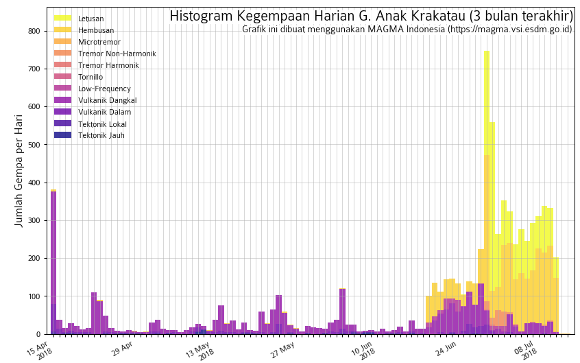
Level of activity at Level 2 (WASPADA). G. Krakatau (305 m above sea level) has increased its volcanic activity since June 18, 2018.
Since yesterday until this morning, the weather was clear and the mountain visually covered with mist. The wind is blowing slightly east and west. The smoke from the main crater is not observed.
The seismographs of July 14, 2018 recorded:
398 eruption earthquakes
Tremor continuous with amplitude from 2 to 45 mm (dominant value: 20 mm)
Recommendation: The company / tourists are not allowed to approach the crater within a radius of 1 km.
Source : Magma Indonésie , PVMBG .
Photo : Aris Yanto
Chile , Nevados de Chillan :
The National Geological and Mining Service (Sernageomin) reported a third explosion with particle expulsion on the Nevados volcano of Chillán, which emitted a column of ash reaching 340 meters in height.
The entity reported in its latest Volcanic Activity Report (VAR) that the event occurred « at 03:24 am today, Sunday, July 15, the monitoring stations set up near the volcanic complex have recorded an earthquake associated with an explosion, driven by fluid dynamics in the volcanic system « .
The explosion occurred at a depth of 1.8 km. and was followed by an earthquake of magnitude M3.8.
It should be mentioned that the volcanic massif remains in technical alert Orange
Supervisory authorities
The Sernageomin explained that although Nevados de Chillán is on the orange volcanic alert, it is possible that the occurrence of new or similar higher energy explosions are reported, which could increase the alert level.
It should be mentioned that Nevados de Chillán corresponds to a volcanic complex of elliptic form, of composition varying between dacitic and andesitic. It is located in the Andean mountain range of the Biobío region, on the border of the municipalities of Coihueco and Pinto.
He has exhibited an eruptive activity for 650,000 years. The eruptions of this complex vary with lava emissions in short periods of time which do not imply an eminent danger for the neighboring population, as in the case of the lava Sebastián (2008), phreatic explosions (Chudcún 2003) to large eruptions during prolonged periods of time: from 1861 to 1865, which generated the volcano Santa Gertrudis (sub-complex of Cerro Blanco), from 1906 to 1948, constructing the volcano Nuevo and from 1973 to 1986, creating the volcano Arrau, both sub-complexes of Las Termas.
Source : Publimetro ( https://www.publimetro.cl/cl/noticias/2018/07/15/volcan-nevados-chillan-reportan-tercera-explosion.html )
Guatemala , Pacaya :
SPECIAL VOLCANOLOGICAL BULLETIN BEPAC # 99-2018 Guatemala 15 July 2018, 22:15 h (Local time)
FLOW OF LAVA on the PACAYA VOLCANO (1402-11)
Type of activity: Strombolian.
Morphology: Composite Stratovolcano
Location: 14 ° 22’50˝ Latitude N; 90 ° 36’00˝ Longitude W.
Height: 2,552msnm
The Pacaya volcano has shown an increase in activity in recent months, common for Strombolian volcanoes such as Pacaya volcano, including internal tremor increases, strombolian explosions and projection of materials at heights ranging from 15 to 75 meters as well as presence of lava flows that persist between a few hours and several months.
Recently the presence of a lava flow on the North-North-West flank has been recorded, until today it reaches a length of approximately 400 meters. On its way it raises particles that are quickly dispersed by the wind and causes small avalanches
There has been no reported increase in explosive activity or the presence of ash in the environment, but it is not excluded that they will occur at any given time and even if there are more lava in the following hours or days or even that a new eruptive phase occurs.
Source : Insivumeh.
Hawai , Kilauea :
Sunday, July 15, 2018, 11:21 AM HST (Sunday, July 15, 2018, 21:21 UTC)
19°25’16 » N 155°17’13 » W,
Summit Elevation 4091 ft (1247 m)
Current Volcano Alert Level: WARNING
Current Aviation Color Code: ORANGE
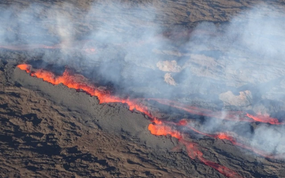
Kīlauea Volcano Lower East Rift Zone
Fissure 8 continues to erupt lava into the perched channel leading northeastward from the vent. Lava levels in the upper channel increased briefly following this morning’s summit collapse-explosion event at 3:26 a.m. Another short-lived overflow of the channel at the vent spread east-southeast this morning, but did not advance beyond the existing flow field. The channelized ʻaʻā flow west of Kapoho Crater continues to be the main ocean entry at the southern edge of the flow front.
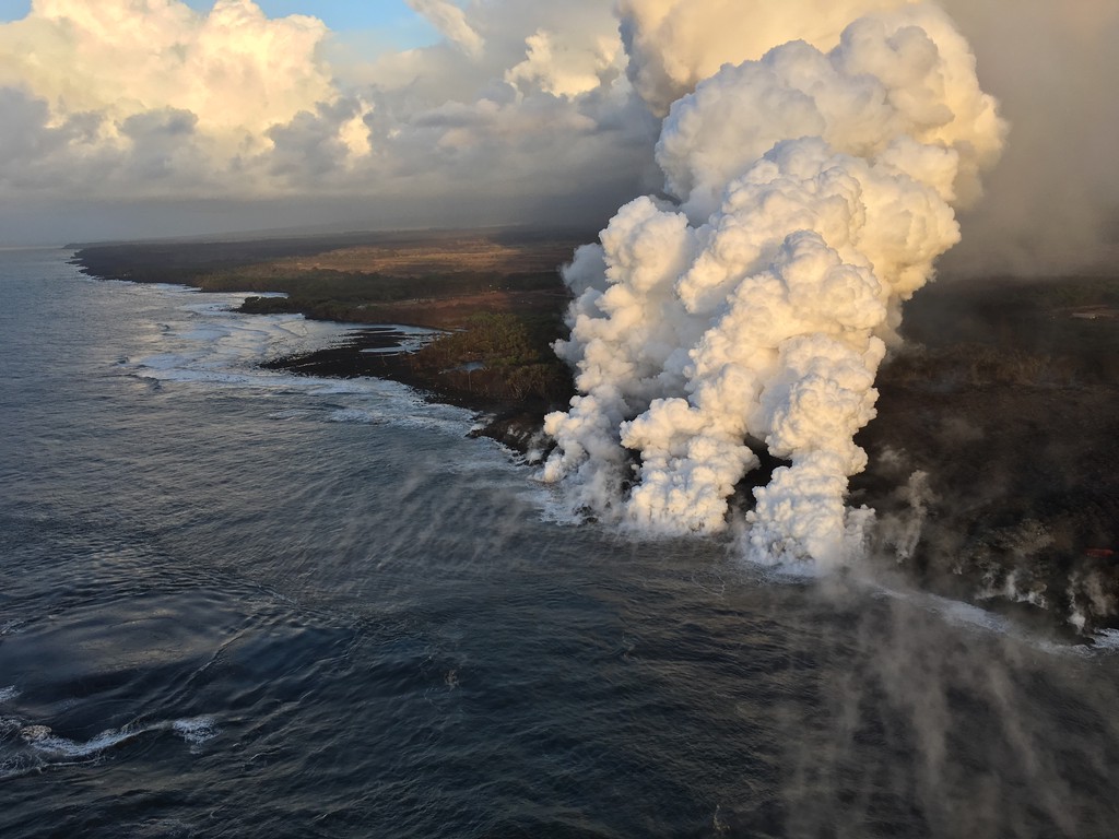
Laze plume rises where lava pours into the sea on the south margin of the fissure 8 flow. This southern boundary did not change location appreciably in the past day, remaining about 900 m (0.56 mi) from the boat ramp at Isaac Hale Park.
The southern margin of the flow remained about 1 km (0.6 mi) from Isaac Hale Park this morning. Despite no visible surface connection to the fissure 8 channel, lava continues to ooze out at several points on the 6 km (3.7 mi) wide flow front into the ocean.
No other fissures are active this morning.
Kīlauea Volcano Summit
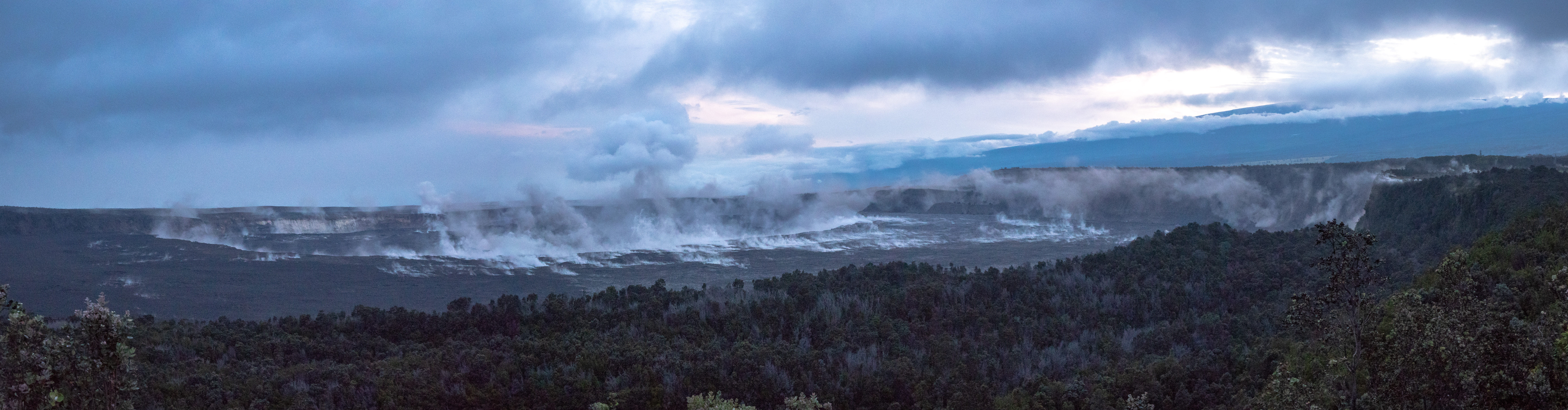
A stunning panoramic view of Kīlauea’s summit captured shortly after the 7:08 a.m. HST summit collapse event on Friday, July 13. Ashy dust stirred up by rockfalls can be seen rising from within Halema‘uma‘u (center) and the caldera wall (far right).
At 3:26 a.m. HST July 15, a collapse/explosion occurred beneath the summit of Kīlauea with energy equivalent to a magnitude-5.2 earthquake. Seismic activity at the summit decreased immediately following the event, but is beginning to increase at this time. We expect the number of earthquakes to increase through Monday morning or afternoon until the next collapse/explosion occurs.
Source : HVO