July 12 , 2018 .
Hawai , Kilauea :
Wednesday, July 11, 2018, 12:45 PM HST (Wednesday, July 11, 2018, 22:45 UTC)
19°25’16 » N 155°17’13 » W,
Summit Elevation 4091 ft (1247 m)
Current Volcano Alert Level: WARNING
Current Aviation Color Code: ORANGE
Kīlauea Volcano Lower East Rift Zone
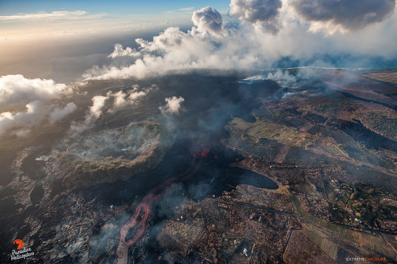
This photo shows the new path of the channelized flow around the west side of Kapoho Crater, as it advances toward Ahalanui Beach Park and Kua O Ka La Charter School…
Fissure 8 continues to erupt lava into the perched channel leading northeastward from the vent. The upper channel between Fissure 8 and Pohoiki Rd. started overflowing about 8:30 or 9 am with a few lobes advancing a short distance beyond previous flows threatening a few houses on Luana and Nohea Streets. Last night and this morning, the channel was apparently blocked again just west of Kapoho Crater and a majority of channel lava began flowing south along the west edge of previous flows west of Kapoho Crater. By 10 am, this channelized ʻaʻā flow had advanced within 2,000 ft of the coast at Ahalanui Beach Park. The ocean entry continues to be active with more centralized building of a broad point into the ocean.
Fissure 22 continues to exhibit weak spattering. No other fissures are active.
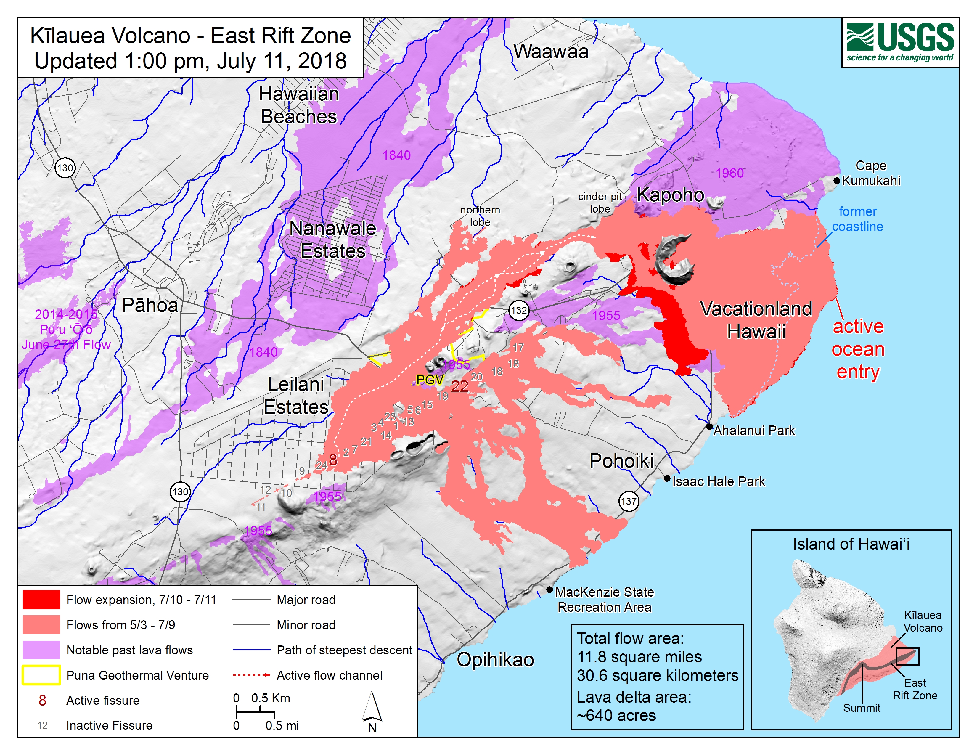
Map as of 1:00 p.m. HST, July 11, 2018. Given the dynamic nature of Kīlauea’s lower East Rift Zone eruption, with changing vent locations, fissures starting and stopping, and varying rates of lava effusion, map details shown here are accurate as of the date/time noted. Shaded purple areas indicate lava flows erupted in 1840, 1955, 1960, and 2014-2015.
Kīlauea Volcano Summit
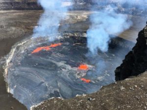
At 5:46 AM HST on July 11, a collapse/explosion occurred beneath Kilauea caldera with energy equivalent to a magnitude-5.3 earthquake. The number of earthquakes dropped from 30-40/hr to less than 10/hr. We expect the earthquakes to increase over the next day until the next collapse/explosion tomorrow. Inward slumping of the rim and walls of Halemaʻumaʻu continues in response to the ongoing subsidence at the summit.
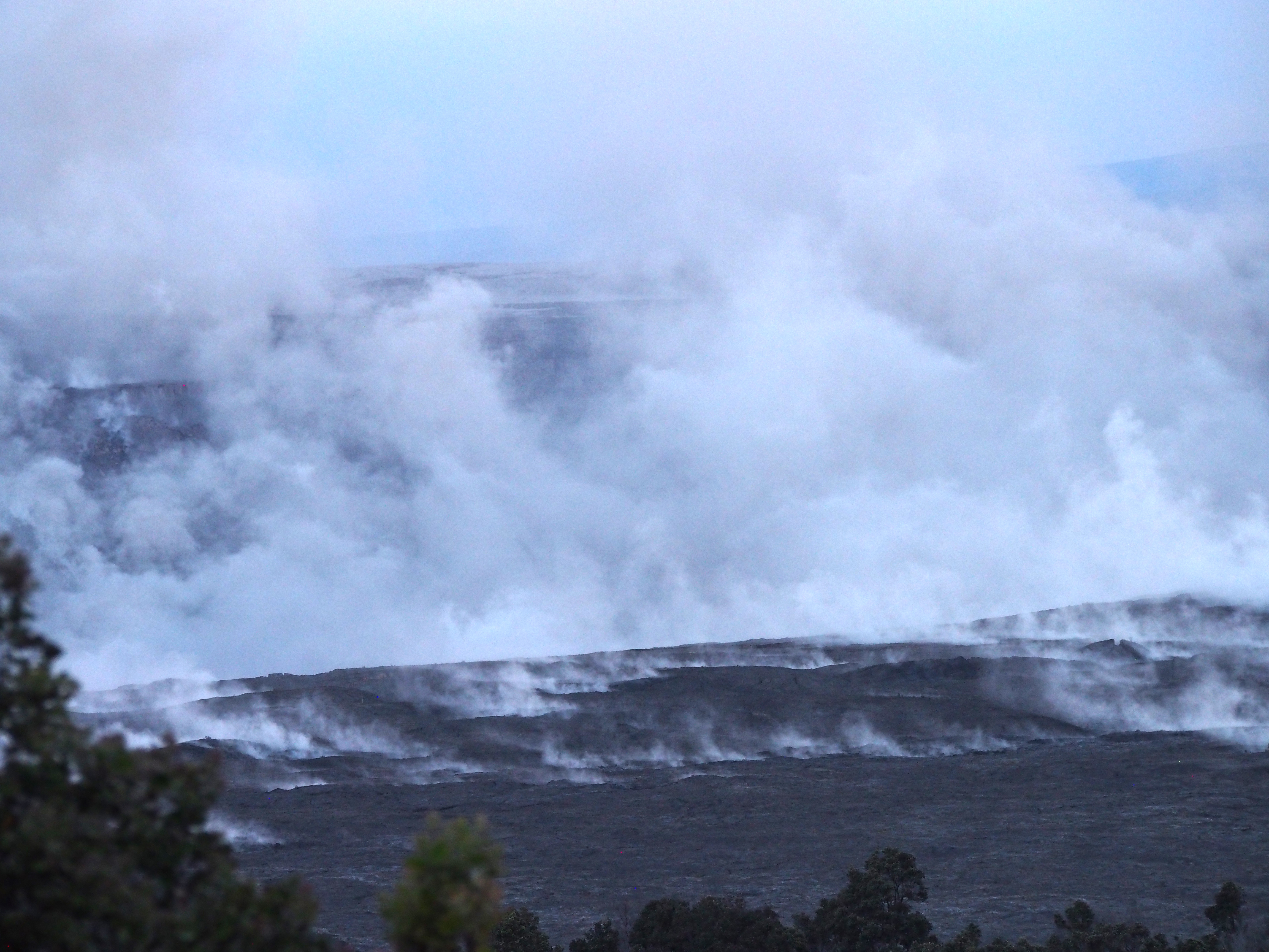
A telephoto view of the eastern edge of Halema‘uma‘u taken just two minutes after today’s (July 11) 5:45 a.m. HST collapse explosion event. Steam is intermixed with minor ash that imparts a pinkish-brown color to the plume. The energy released by the event was equivalent to a magnitude-5.3 earthquake.
The collapse/explosive event this morning was followed by an increase in lava from the fissure 8 vent which has produced small overflows from the upper channel that are threatening a few homes on Nohea and Luana streets.
Source : HVO
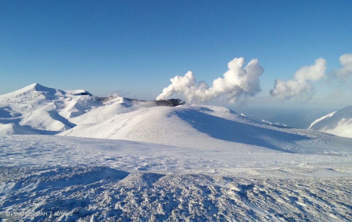
Kamchatka , Ebeko :
VOLCANO OBSERVATORY NOTICE FOR AVIATION (VONA).
Issued: July 11 , 20180711/0558Z
Volcano:Ebeko (CAVW #290380)
Current aviation colour code:ORANGE
Previous aviation colour code:orange
Source:KVERT
Notice Number:2018-59
Volcano Location:N 50 deg 41 min E 156 deg 0 min
Area:Northern Kuriles, Russia
Summit Elevation:3791.68 ft (1156 m)
Volcanic Activity Summary:
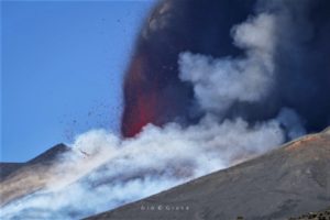
According to satellite data, a moderate explosive activity of Ebeco volcano continues. Ash cloud drift to the west from the volcano
A moderate gas-steam with some amount of ash activity of the volcano continues. Ash explosions up to 16,400 ft (5 km) a.s.l. could occur at any time. Ongoing activity could affect low-flying aircraft and airport of Severo-Kurilsk.
Volcanic cloud height:
6560-8200 ft (2000-2500 m) AMSL Time and method of ash plume/cloud height determination: 20180711/0530Z – Himawari-8
Other volcanic cloud information:
Distance of ash plume/cloud of the volcano: 16 mi (26 km)
Direction of drift of ash plume/cloud of the volcano: W / azimuth 272 deg
Time and method of ash plume/cloud determination: 20180711/0530Z – Himawari-8
Source : Kvert
Photo : T. Kotenko, IVS FEB RAS , 12/1/2017 .
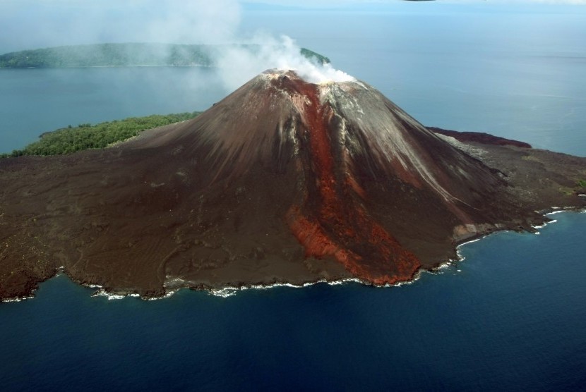
Indonesia , Krakatau :
6.102°S, 105.423°E
Elevation 813 m
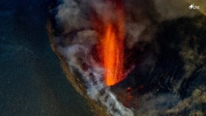
PVMBG reported that during 4-5 July there were four ash-producing events at Anak Krakatau, each lasting between 30 and 41 seconds. Inclement weather conditions prevented an estimation of the ash-plume height from the event at 0522 on 4 July; ash plumes from events at 1409, 1425, and 1651 on 5 July rose 300-500 m above the crater rim and drifted N and NW. The Alert Level remained at 2 (on a scale of 1-4); residents and visitors were warned not to approach the volcano within 1 km of the crater.
Anak Krakatau has increased its volcanic activity.
LAMPUNG – Mount Anak Krakatau in the Sunda Strait, Lampung Province is again erupting. The Center for Volcanology and Geological Hazard Mitigation (PVMBG) reported that Anak Krakatau erupted 56 times with a height of ash columns ranging from 200 meters to 1,000 meters above the crater summit on Wednesday. (11/ 7).
Head of Information and Public Relations of the National Disaster Management Agency (BNPB) Sutopo Purwo Nugroho said that in 24 hours, from 00.00 to 24.00 pm on Wednesday (11/7), Anak Krakatau presented 56 events, with amplitudes of 25 to 53 mm, and eruption times of 20 to 100 seconds.
« The eruption is accompanied by emission of volcanic ash, sand and a thud. Visually at night we observe the incandescent lava. Earlier, Tuesday (10/7) Anak Krakatau had presented 99 events with amplitudes of 18 to 54 mm and eruption duration of 20 to 102 seconds.
He added that the number of such eruptions has actually occurred since June 18, 2018, because the volcano has increased its volcanic activity. There is a movement of magma towards the surface resulting in an eruption.
« However, the status of Mount Anak Krakatau remains at alert level 2 (WASPADA, there is no increase in the status of the mountain, » he said.
This condition is not prejudicial as long as the community does not operate within a radius of 1 km. The cruise line in the Sunda Strait remains safe. The eruption is also harmless as long as it is outside the radius of 1 km around the summit of the crater.
« The eruption of Mount Anak Krakatau is common, it is always active to grow with each eruption, » he said.
He explains that the history of the Anak Krakatau, which recently emerged from sea level in 1927, has its average height increased by 4 to 6 meters per year. Nevertheless, he is optimistic because the erupting energy released is also not great. « Very little risk of major eruptions such as the eruption of Mount Krakatau in 1883. Even some experts say it is impossible at the moment, » he said.
Source: GVP , Pusat vulkanologi dan Mitigasi Bencana Geologi (PVMBG ), REPUBLIKA.CO.ID .
Photo : Antara , Aris Yanto.
Vanuatu , Ambae :
VANUATU VOLCANO ALERT BULLETIN N°6 – AMBAE ACTIVITY , Tuesday July 10th 2018
15°24’0”S 167°50’0”E
Summit 4908ft (1496m)
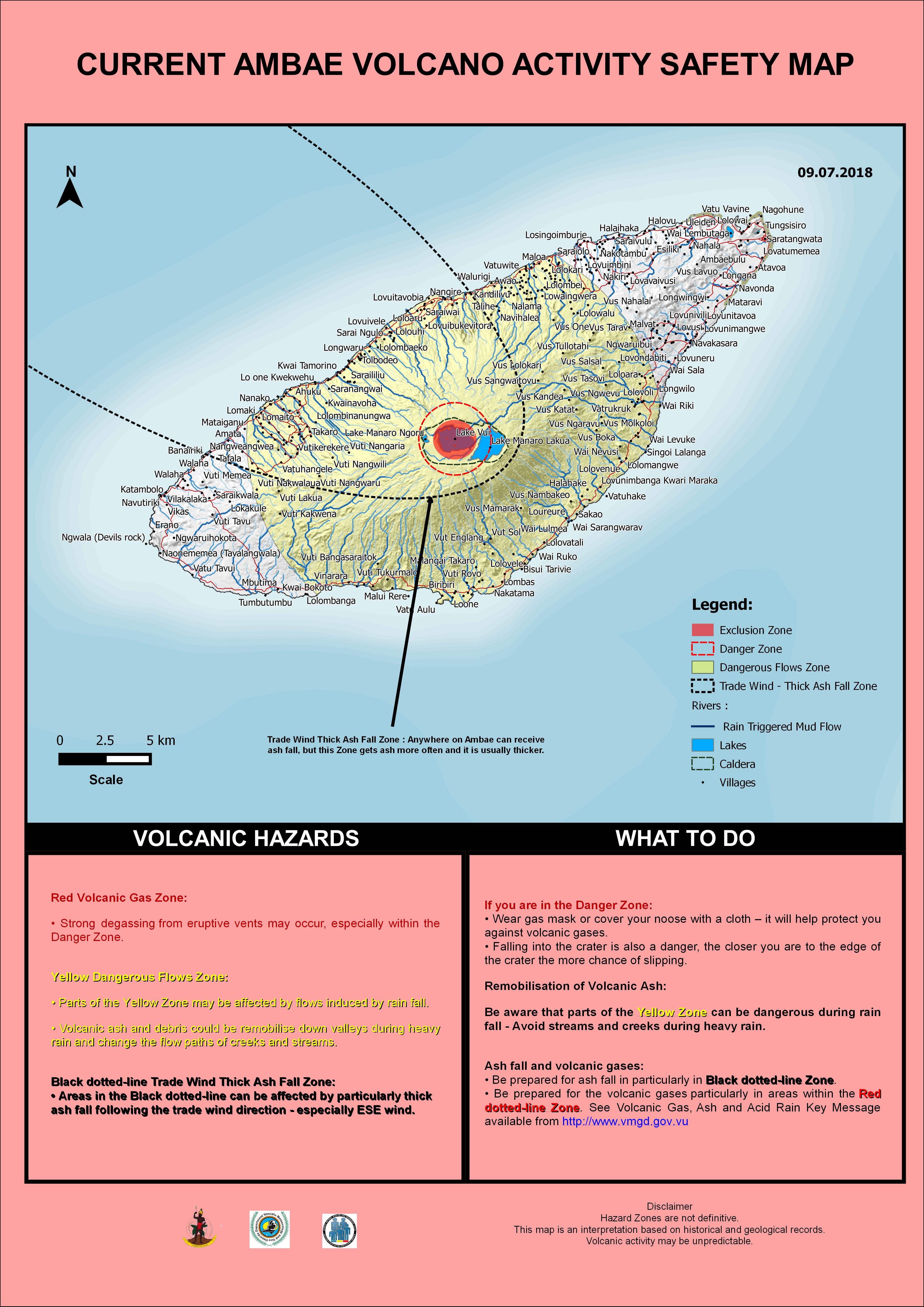
Current Volcano Alert Level: Level 2
Ambae volcano is continuing in the major unrest state. The Volcanic Alert Level remains at Level 2 .
Volcanic unrest is continuing at Ambae. The current volcanic activity is consistent with Volcanic Alert Level 2. The Danger Zone for life safety is limited at 2 km radius from the active vent and areas located in the Yellow Zone (See Map below).
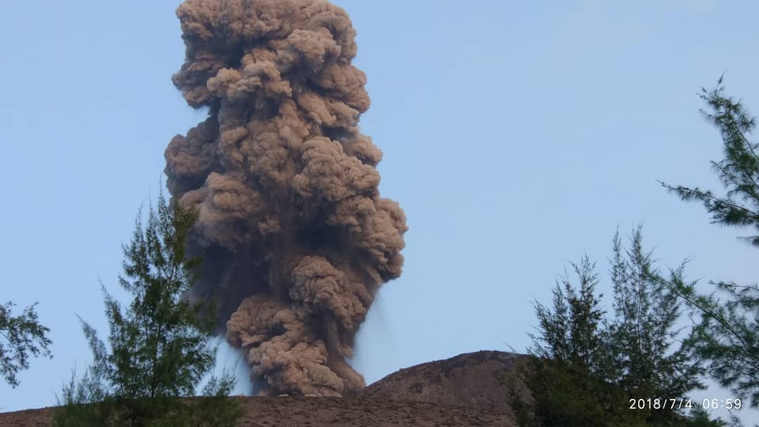
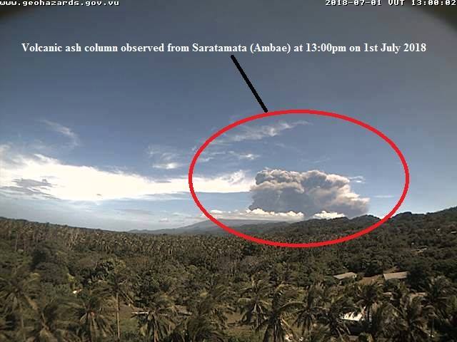
Observations in June 2018 confirm that the Ambae volcano activity is not stable since 20th June. On the 1st of July, the volcano emitted a column of ash which induced heavy to light ash fall at villages especially from North-West to West of Ambae Island and also the North-Eastern part of Santo Island driven by the prevailing trade wind. A small eruption scale in Lake Voui is continuing.
The presence of ash that has fallen on Ambae during the last eruptive phases will continue to change the behavior of streams and creeks when it rains. The creeks and streams can produce floods and carry a lot more debris (sands, gravel and boulders). The flow path of streams and creeks could change due to the flood debris. Landslide may occur at some areas during heavy rain fall.
These observations and the analysis of seismic data confirm that the volcano activity is continuing in the major unrest state. The volcano activity consist of ongoing emission of steam and/or gases and sometimes ashes. The local population from Ambae and from neighboring island can hear rumbling from volcano, see volcanic ash and gas plume and glows over the mountain at night.
Significant impact of ashes and gases emission to villages at Ambae started in March, when the Volcanic Alert level was raised to Level 3. Observations of the current activity are consistent with the Alert Level 2 activity. Level 2 indicates ‘Major unrest; Danger is now at 2 km around the volcanic vents and areas inside the Yellow Zone’ . The possibility that the Ambae volcano activity escalate to the level of minor eruption is low to moderate .
Source : Geohazard Vanuatu.
Photo : Geohazard / Volcano Global Update Center