October 30 , 2021.
Spain / La Palma , Cumbre Vieja :
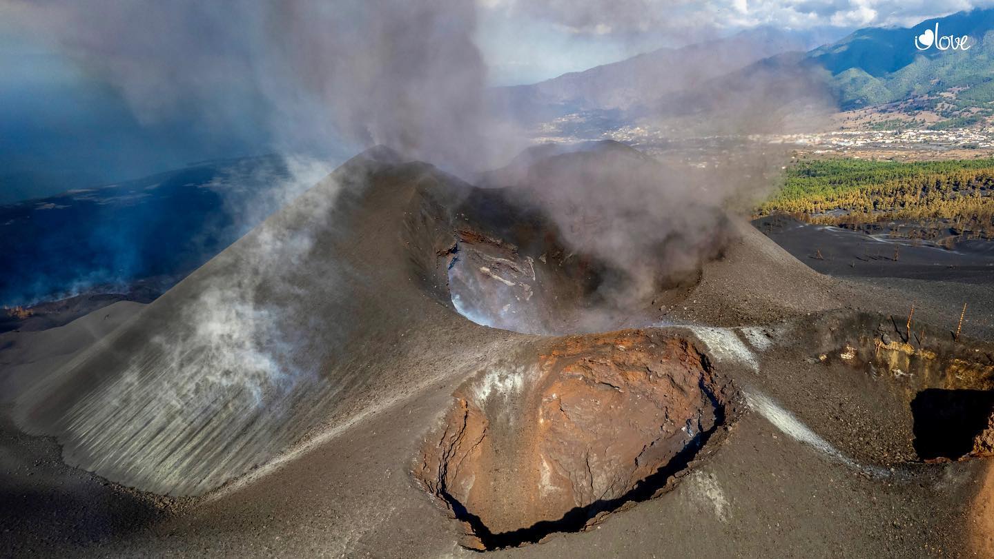
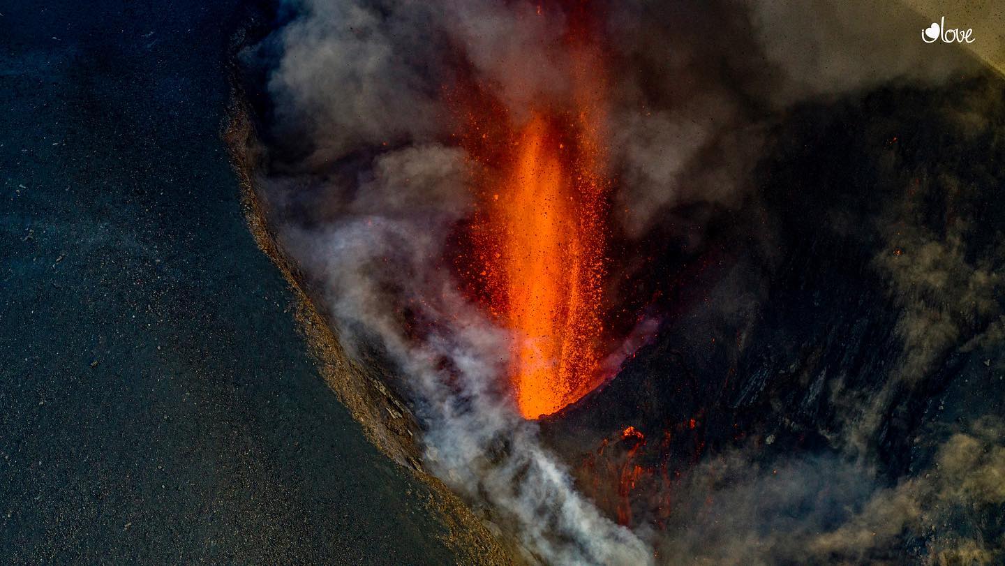
October 29, 2021, 11:30 am UTC. Eruptive activity continues on La Palma:
Since the last press release, 159 earthquakes have been located in the area affected by the volcanic reactivation of Cumbre Vieja, 15 of these earthquakes were felt by the population, having reached the maximum intensity in the epicentral zone IV (EMS98 ) for 6 earthquakes.
The largest earthquake is the one located at 20:21 on the 28th, with a magnitude of 4.2 mbLg and a depth of 38 km, which was felt with a maximum intensity of IV on the island of La Palma.
Seven earthquakes were located at depths of about 30 km, the rest of the hypocenters of the period are located at a shallower depth, about 12 km.
The amplitude of the volcanic tremor signal was maintained at high average levels, with intensifying pulses.
The island’s network of permanent GNSS stations shows that the elevation recorded on the 25th at station LP03, which is closest to the eruptive centers, has reversed. However, the southern deformation recorded by the station was only partially recovered. At the most remote stations, a slight deflation is maintained, possibly related to deep seismicity.
In view of the calibrated image, it is estimated: Height of the column: 3300 m UTC time: 7.45 a.m.
The director of the National Geographical Institute (IGN) and spokesperson for the Scientific Committee of Pevolca, María José Blanco, reported on Friday that from the lava-emitting focus on the northwest flank of the main cone of the Cumbre Vieja volcano, a flow currently moving southwest on previous flows. This flow branched off into two arms, one of which advances to the West and the other to the South-West, which passed the front of flows 1 and 2, moving over previously unaffected land in a South-West direction , advancing over the last 24 hours 900 meters.
Here are the most remarkable data from his report:
The fissure eruption continues to show a Strombolian mechanism and the Volcanic Explosive Index (VEI) remains at level 2. The eruption maintains the same behavior pattern as the last three days and the cone morphology continues to change Many times.
· The height measured today of the eruptive column is 3,300 meters.
· The atmospheric situation is favorable for the operation of airports in the Canary Islands.
· Seismicity continues to be located in the same areas and at depths between 10 and 15 kilometers and less than 20 kilometers. Yesterday, the magnitude of 4.2 was reached. The current level of seismicity continues to indicate that it is possible for other earthquakes to occur and cause small landslides in sloping areas.
Source : IGN es , El Pais .
Photos : I love the world .
Alaska , Semisopochnoi :
51°55’44 » N 179°35’52 » E,
Summit Elevation 2625 ft (800 m)
Current Volcano Alert Level: WATCH
Current Aviation Color Code: ORANGE
The north crater of Mount Cerberus on Semisopochnoi Island remained active, and minor explosions were observed multiple times a day in geophysical and remote sensing data throughout the week. Low-level ash emissions were seen in web camera views regularly during clear weather. Ash plumes up to ~5,000 ft above sea level were observed most days in satellite imagery and typically dissipated within 100 km (62 miles) of the volcano. The longest plume extended up to ~150 km (~100 miles) on October 23. On October 26, 27, and 29, ash plumes up to 10,000-12,000 feet were seen in satellite data. Sulfur dioxide emissions were also observed in satellite imagery on three days during the past week.
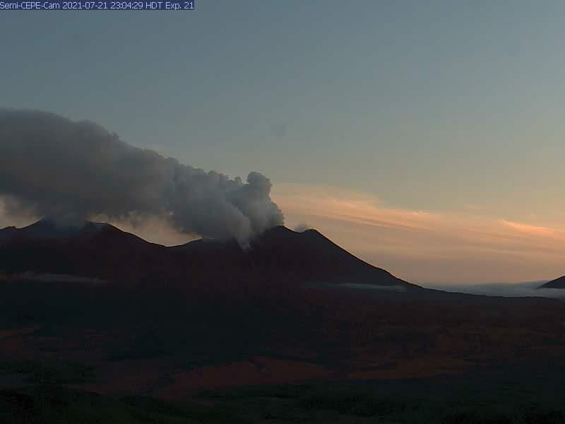
Small eruptions producing minor ash deposits within the vicinity of the active north crater of Mount Cerberus and ash clouds under 10,000 feet above sea level have characterized the recent activity and show no signs of abating.
Semisopochnoi is monitored by local seismic and infrasound sensors, satellite data, web cameras, and remote infrasound and lightning networks.
Source et photo : AVO
Ecuador , Reventador :
DAILY REPORT OF THE STATE OF THE REVENTADOR VOLCANO, Thursday, October 28, 2021.
Information Geophysical Institute – EPN.
Surface activity level: High, Surface trend: No change.
Internal activity level: Moderate, Internal trend: No change.
Seismicity: From October 27, 2021, 11: 00h to October 28, 2021, 11: 00h:
The seismic statistics were carried out at the Cascales station, due to the persistent intermittence in the local network of the Reventador volcano.
Explosion (EXP): 61 events
Rains / lahars: There was no rain in the area.
Emission column / ash:
In the early hours of the morning, gas and ash emissions were recorded towards the North-North-West and heights exceeding 1000 meters above the level of the crater. The Washington VAAC recorded 2 ash emission alerts observed by satellites at altitudes of 700 and 1,400 meters above crater level in the north and northwest directions.
Other monitoring parameters:
No thermal alert has been recorded by satellite systems for this volcano.
Observation:
Most of the time, the volcano has been cloudy for the past 24 hours. With the exception of the early hours of the morning today when the emissions described above were observed as well as the rolling of incandescent materials on the sides of the volcano up to 500 meters below the level of the crater.
Niveau d’alerte: Orange.
Source et photo : IG-EPN.
Kamchatka , Karymsky :
VOLCANO OBSERVATORY NOTICE FOR AVIATION (VONA)
Issued: October 30 ,20211030/0348Z
Volcano: Karymsky (CAVW #300130)
Current aviation colour code: ORANGE
Previous aviation colour code: orange
Source: KVERT
Notice Number: 2021-131
Volcano Location: N 54 deg 2 min E 159 deg 26 min
Area: Kamchatka, Russia
Summit Elevation: 1486 m (4874.08 ft)
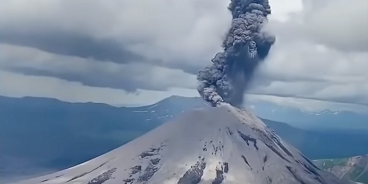
Volcanic Activity Summary:
A moderate eruptive activity of the volcano continues. Satellite data by KVERT showed: explosions sent ash up to 2.5 km a.s.l., and ash plume is extending about 120 km to the east of the volcano.
This activity continues. Ash explosions up to 7-8 km (23,000-26,200 ft) a.s.l. could occur at any time. Ongoing activity could affect international and low-flying aircrafts.
Volcanic cloud height:
2300-2500 m (7544-8200 ft) AMSL Time and method of ash plume/cloud height determination: 20211030/0218Z – JPSS-1 (14m15)
Other volcanic cloud information:
Distance of ash plume/cloud of the volcano: 120 km (75 mi)
Direction of drift of ash plume/cloud of the volcano: E / azimuth 92 deg
Time and method of ash plume/cloud determination: 20211030/0218Z – JPSS-1 (14m15)
Source : Kvert.
Photo : Daily Afisha. Ru.
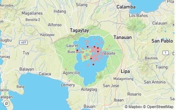
Philippines , Taal :
TAAL VOLCANO BULLETIN 30 October 2021 8:00 AM
In the past 24-hour period, the Taal Volcano Network recorded one hundred three (103) volcanic earthquakes, including twenty-one (21) volcanic tremor events having durations of one (1) to two (2) minutes, seventy-four (74) low-frequency volcanic earthquakes, eight (8) hybrid events, and low-level background tremor that has persisted since 7 July 2021.
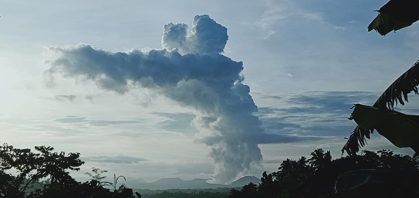
Activity at the Main Crater was dominated by upwelling of hot volcanic fluids in its lake which generated plumes 1,200 meters tall that drifted south-southwest. Sulfur dioxide (SO2) emission averaged 5,943 tonnes/day on 29 October 2021. Based on ground deformation parameters from electronic tilt, continuous GPS and InSAR monitoring, Taal Volcano Island has begun inflating in August 2021 while the Taal region continues to undergo very slow extension since 2020.
Alert Level 2 (Increased Unrest) prevails over Taal Volcano. DOST-PHIVOLCS reminds the public that at Alert Level 2, sudden steam- or gas-driven explosions, volcanic earthquakes, minor ashfall, and lethal accumulations or expulsions of volcanic gas can occur and threaten areas within and around TVI.
Source and map : Phivolcs
Photo : JhuLia Mendoza.
Mexico , Popocatepetl :
October 29, 11:00 a.m. (October 29, 4:00 p.m. GMT)
During the last 24 hours, according to the monitoring systems of the Popocatépetl volcano, 77 exhalations and 44 minutes of tremors have been identified). Between 5:15 am and 6:50 am today, a sequence of expirations lasting 66 minutes was detected. In some cases, water vapor and gas emissions have been observed.
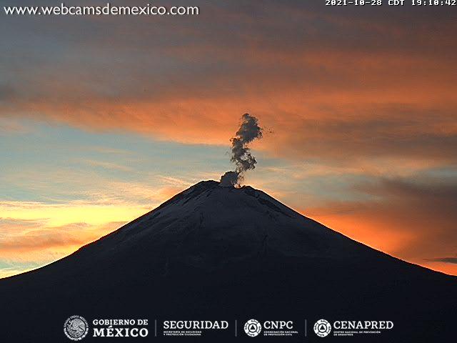
At the time of this report, the volcano is observed, with a slight emission of steam and gas that is heading east-southeast.
CENAPRED recommends NOT TO APPROACH the volcano and especially the crater, because of the danger of falling ballistic fragments and, in the event of heavy rains, to stay away from the bottom of the ravines because of the danger mudslides and debris.
Source et photo : Cenapred.