June 22 , 2018.
Pu’u ‘Ō’ō / Kilauea , Hawai :
Thursday, June 21, 2018, 6:11 PM HST (Friday, June 22, 2018, 04:11 UTC)
19°25’16 » N 155°17’13 » W,
Summit Elevation 4091 ft (1247 m)
Current Volcano Alert Level: WARNING
Current Aviation Color Code: RED
Kīlauea Volcano Lower East Rift Zone
The eruption in the lower East Rift Zone (LERZ) continues with little change.
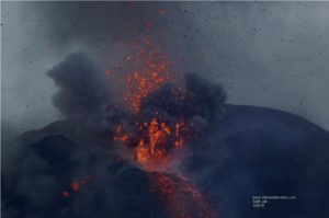
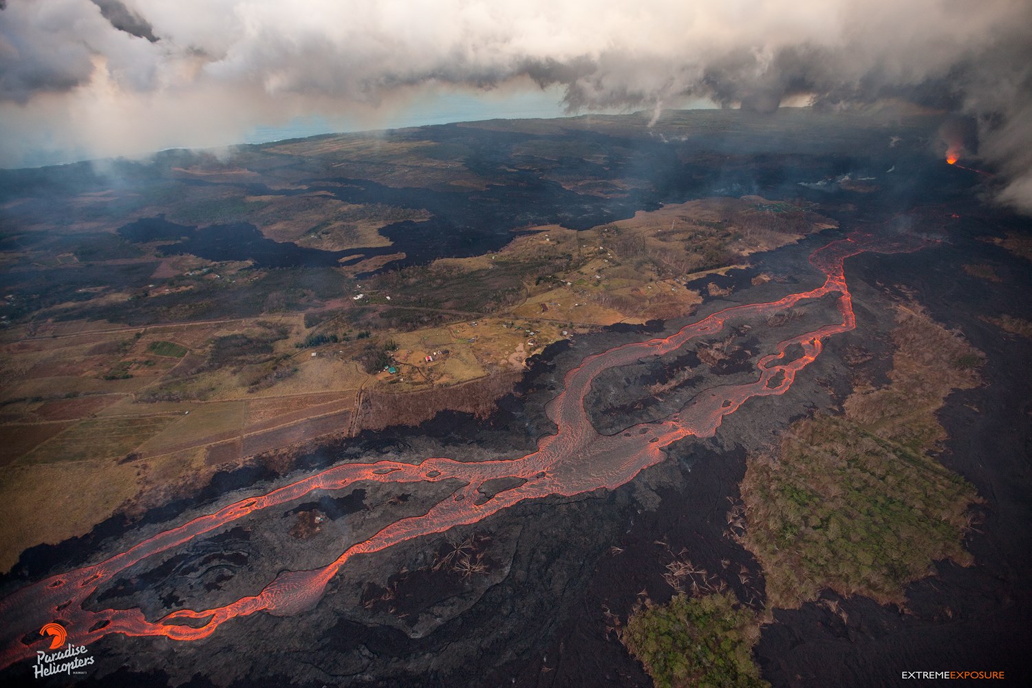
Lava fountains from the Fissure 8 spatter cone continue to feed the established channel that transports lava to the ocean at the Kapoho coastline. One main ocean entry on the south edge of the flow front at the coast is producing a laze plume that is being blown onshore. No overflows from the channel were observed this morning. Fissure 6 was weakly active overnight with at least one short flow active visible in the PGcam. Fissure 16/18 and 22 displayed some incandescence early this morning.

Pele’s hair and other lightweight volcanic glass fragments from the lava fountain at Fissure 8 continue to fall downwind of the fissure, dusting the ground within a few hundred meters (yards) of the vent. High winds may waft lighter particles to greater distances. Residents are urged to minimize exposure to these volcanic particles, which can cause skin and eye irritation similar to volcanic ash.
HVO field crews are on site tracking the fountains, lava flows, and spattering from Fissure 8 as conditions allow and are reporting information to Hawaii County Civil Defense. Observations are also collected on a daily basis from cracks in the area of Highway 130; no changes in temperature, crack width, or gas emissions have been noted for several days.
https://www.facebook.com/K.BryanHI/videos/1981705111862567/
Volcanic gas emissions remain very high from Fissure 8 eruptions. Returning trade wind conditions are expected to bring VOG to the southern and western parts of the Island of Hawaii. VOG information can be found at https://vog.ivhhn.org/
The ocean entry is a hazardous area. Venturing too close to an ocean entry on land or the ocean exposes you to flying debris from sudden explosive interaction between lava and water. Also, the lava delta is unstable because it is built on unconsolidated lava fragments and sand. This loose material can easily be eroded away by surf, causing the new land to become unsupported and slide into the sea. Additionally, the interaction of lava with the ocean creates « laze », a corrosive seawater plume laden with hydrochloric acid and fine volcanic particles that can irritate the skin, eyes, and lungs.
Magma continues to be supplied to the Lower East Rift Zone. Seismicity remains relatively low in the area with numerous small magnitude earthquakes and low amplitude background tremor. Higher amplitude tremor is occasionally being recorded on seismic stations close to the ocean entry.
Additional ground cracking and outbreaks of lava in the area of the active fissures are possible. Residents downslope of the region of fissures should heed all Hawaii County Civil Defense messages and warnings.
Kīlauea Volcano Summit
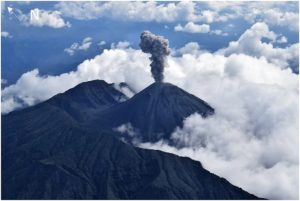
AT 1:13 PM HST, a collapse/explosion event occurred at the summit of Kīlauea Volcano. The gas plume had little ash in it and wafted no more than 1,000 ft above the ground. Inward slumping of the rim and walls of Halemaʻumaʻu continues in response to ongoing subsidence at the summit.

Sulfur dioxide emissions from the volcano’s summit have dropped to levels that are about half those measured prior to the onset of the current episode of eruptive activity. This gas and minor amounts of ash are being transported downwind, with small bursts of ash and gas accompanying intermittent explosive activity.
Source : HVO
Photos : Bruce Omori , USGS .
Video : Ken Boyer
Mauna Loa , Hawai :
HVO/USGS Volcanic Activity Notice
Current Volcano Alert Level: NORMAL
Previous Volcano Alert Level: ADVISORY
Current Aviation Color Code: GREEN
Previous Aviation Color Code: YELLOW
Issued: Thursday, June 21, 2018, 1:46 PM HST
Source: Hawaiian Volcano Observatory
Notice Number:
Location: N 19 deg 28 min W 155 deg 36 min
Elevation: 13681 ft (4170 m)
Area: Hawaii
Volcanic Activity Summary:
HVO seismic and deformation monitoring networks have been recording near background levels of seismicity and ground motion at Mauna Loa Volcano for at least the last six months. These observations indicate that the volcano is no longer at an elevated level of activity. Accordingly, HVO is dropping the Mauna Loa alert level to NORMAL and the aviation color code to GREEN.
HVO continues to monitor the volcano closely and will report any significant changes.
Stay informed about Mauna Loa by following volcano updates and tracking current monitoring data on the HVO web page (http://hvo.wr.usgs.gov/activity/maunaloastatus.php) or by signing up to receive updates by email at this site: http://volcanoes.usgs.gov/vns/
Recent Observations:
[Volcanic cloud height] Unknown
[Other volcanic cloud information] Unknown

Remarks:
From 2014 through much of 2017, HVO seismic stations recorded variable, but overall elevated rates of shallow, small-magnitude earthquakes beneath Mauna Loa’s summit, upper Southwest Rift Zone, and west flank. During that same time period, HVO measured ground deformation consistent with input of magma into the volcano’s shallow magma storage system.
These observations indicated that volcano was not at background levels of activity and the volcano alert level was raised to ADVISORY and the aviation color code to YELLOW in September 2015. It was noted at the time that the increase in alert level did not mean that an eruption was imminent or that progression to an eruption was certain. Indeed, this episode of unrest lasted several years without progressing to an eruption, similar to the period of unrest from 2004 to 2009.
Since late 2017, rates of earthquake occurrence and of ground motion related to inflation of shallow magma reservoirs have slowed to near background levels.
Seismicity has continued to be low during the current activity on Kīlauea volcano. Recent motions recorded by GPS instruments on Mauna Loa are due to the M6.9 Kīlauea south flank earthquake on May 4, 2018 and subsidence at the summit Kīlauea Volcano. None of the activity on Kīlauea volcano has had a detectable effect on Mauna Loa’s magmatic system.

Background:
Mauna Loa is the largest active volcano on Earth. Eruptions typically start at the summit and, within minutes to months of eruption onset, about half of the eruptions migrate into either the Northeast or Southwest Rift Zones. Since 1843, the volcano has erupted 33 times with intervals between eruptions ranging from months to decades. Mauna Loa last erupted 34 years ago, in 1984.
Mauna Loa eruptions tend to produce voluminous, fast-moving lava flows that can impact communities on the east and west sides of the Island of Hawai`i. Since the mid-19th century, the city of Hilo in east Hawai’i has been threatened by seven Mauna Loa lava flows. Mauna Loa lava flows have reached the south and west coasts of the island eight times: 1859, 1868, 1887, 1926, 1919, and three times in 1950.
Source et photos : USGS
Krakatau , Indonesia :
Apparently, the Krakatau is coming back to life. No information on the PVGMBH. The only news was broadcast by Andi Volcanist and Sherine France.
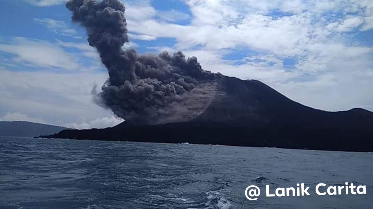
Mt Krakatau has just erupted again indicated from its activity yesterday. That seems still minor though. Will combine and geeting more info from observatory seismogram today of what is the next going on it.
Thanks to my local guide friend Lanik who taken this photo to allow me to share it for the knowledge and my friend Roman from Carita.
Photo : Lanik Carita
Telica , Nicaragua :
This Thursday at 7:08 am Telica volcano, located in León, produced an explosion in which he expelled abundant gas, ash, sand and some rocks, reported the Nicaraguan Institute of Territorial Studies, INETER.
According to the report of this institute, the column was raised 500 meters above the edge of the crater and moved part to the East, South and Southwest. Rock fragments ejected fell near the crater, while the sandy material reached up to 1 kilometer.
After this explosion, the volcano emits gases, but they do not represent a greater danger for the population. New explosions are likely to occur during the day. The communities that have reported the presence of volcanic ash are: Los Manglares, Las Marias, Pozo Viejo, El Porvenir and Monte de los Olivos.
This corresponds to a part of the normal activity of an active volcano such as Telica and for the moment this type of activity does not represent a danger for the population. INETER will continue to provide information on the development of this activity.
The Telica volcano is located in the Cordillera Maribios, at 1060 meters above sea level. It is so called to be close to the municipality of the same name.
The Telica was built on an older east-facing volcano, the Listón (800 mt) with a small crater. At the foot of the complex are the fumaroles of San Jacinto and Santa Clara.
The populations surrounding this volcano know the dangers they represent, which is why they are informed thanks to the agencies COMUPRED and SINAPRED, responsible for ensuring the safety and monitoring of this type of natural phenomena in Nicaragua.
Source : Tn8.tv
Photo : Tais Cossa