June 14 , 2018.
Pu’u ‘Ō’ō / Kilauea , Hawai :
Tuesday, June 12, 2018, 11:04 PM HST (Wednesday, June 13, 2018, 09:04 UTC)
19°25’16 » N 155°17’13 » W,
Summit Elevation 4091 ft (1247 m)
Current Volcano Alert Level: WARNING
Current Aviation Color Code: RED
Kīlauea Volcano Lower East Rift Zone
Eruption of lava continues from the lower East Rift Zone (LERZ) fissure system in the area of Leilani Estates.
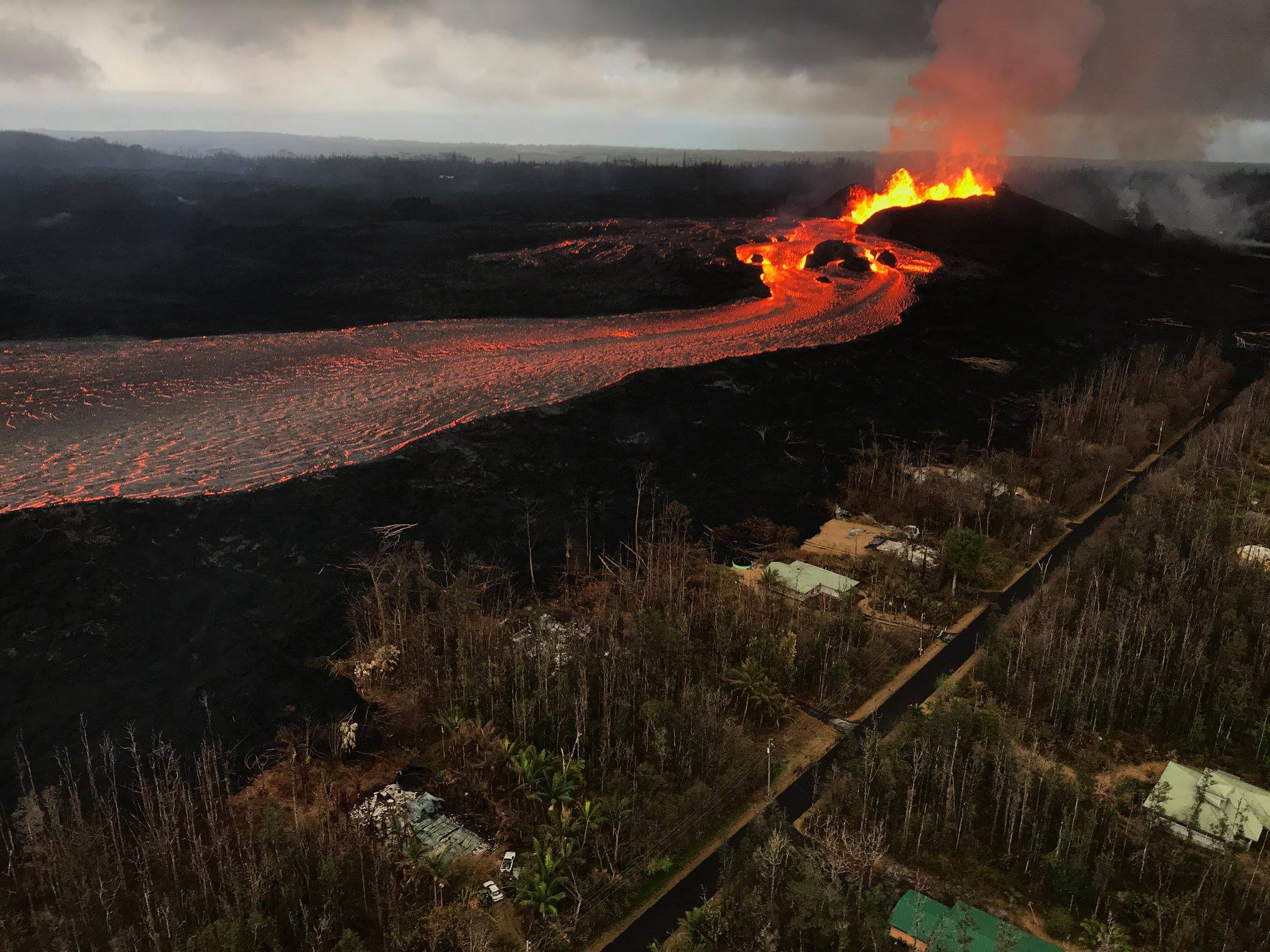
Fissure 8 lava fountains continue to heights of 130-140 ft from within the growing cone of cinder and spatter, which is now about 140 ft at its highest point. Fountaining at Fissure 8 continues to feed the fast moving channelized flow that is entering the ocean at Kapoho. Two prominent entries are creating vigorous steam plumes. Offshore of the entries, areas of upwelling have become more dispersed than when initially sighted. The sporadic spattering from Fissures 16/18 of the last several days has diminished.
Pele’s hair and other lightweight volcanic glass from fountaining of Fissure 8 are falling downwind of the fissure and accumulating on the ground within Leilani Estates. High winds may waft lighter particles to greater distances. Residents are urged to minimize exposure to these volcanic particles, which can cause skin and eye irritation similar to volcanic ash.
HVO field crews are on site tracking the fountains, lava flows, and spattering from Fissure 8 as conditions allow and are reporting information to Hawaii County Civil Defense. Observations are also collected on a daily basis from cracks in the area of Highway 130; no changes in temperature, crack width, or gas emissions have been noted for several days.
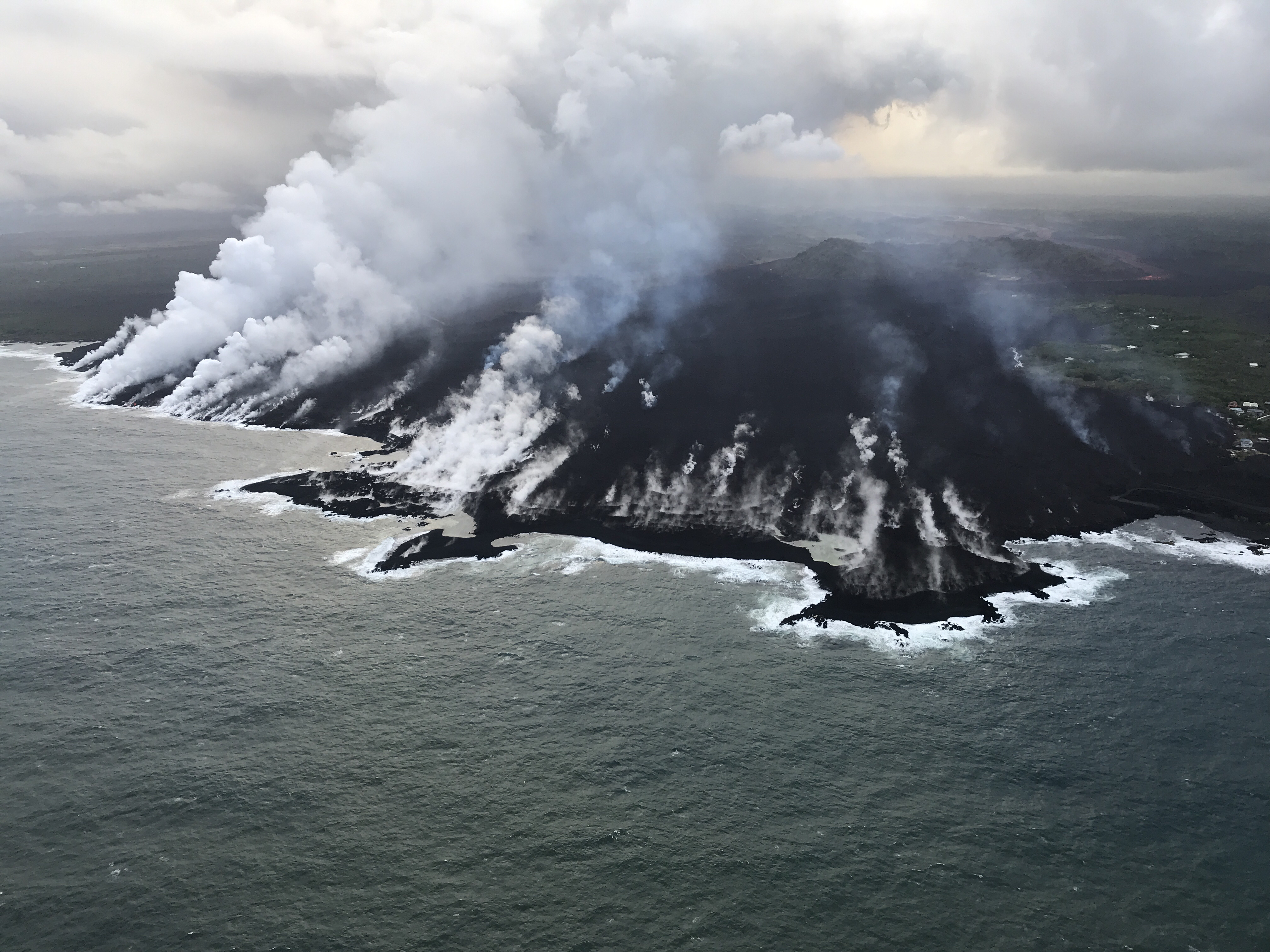
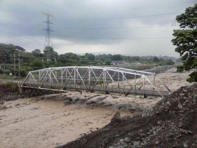
Aerial view of the ocean entry at Kapoho, where a lava delta about 250 acres in size is filling the bay. USGS image taken June 12, 2018, around 6:50 a.m. HST.
Kīlauea Volcano Summit
Seismicity continues to increase after this morning’s explosive eruption. Inward slumping of the rim and walls of Halema`uma`u continues in response to ongoing subsidence at the summit.
Sulfur dioxide emissions from the volcano’s summit have dropped to levels that are about half those measured prior to the onset of the current episode of eruptive activity. This gas and minor amounts of ash are being transported downwind, with small bursts of ash and gas accompanying intermittent explosive activity.
Wednesday, June 13, 2018, 7:27 AM HST (Wednesday, June 13, 2018, 17:27 UTC)
Kīlauea Volcano Lower East Rift Zone
Eruption of lava continues from the lower East Rift Zone (LERZ) fissure system in the area of Leilani Estates.
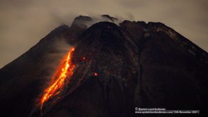
Lava fountain heights of 130-140 ft were observed overnight within the growing cone of cinder and spatter at Fissure 8. Fountaining at Fissure 8 continues to feed the fast moving channelized flow that is entering the ocean at Kapoho. This morning’s overflight of the LERZ observed a towering steam plume from a focused ocean entry point. Offshore of the entries, areas of upwelling have become more dispersed than when initially sighted. The sporadic spattering from Fissures 16/18 of the last several days has diminished, although the fissures continued to glow noticeably overnight.
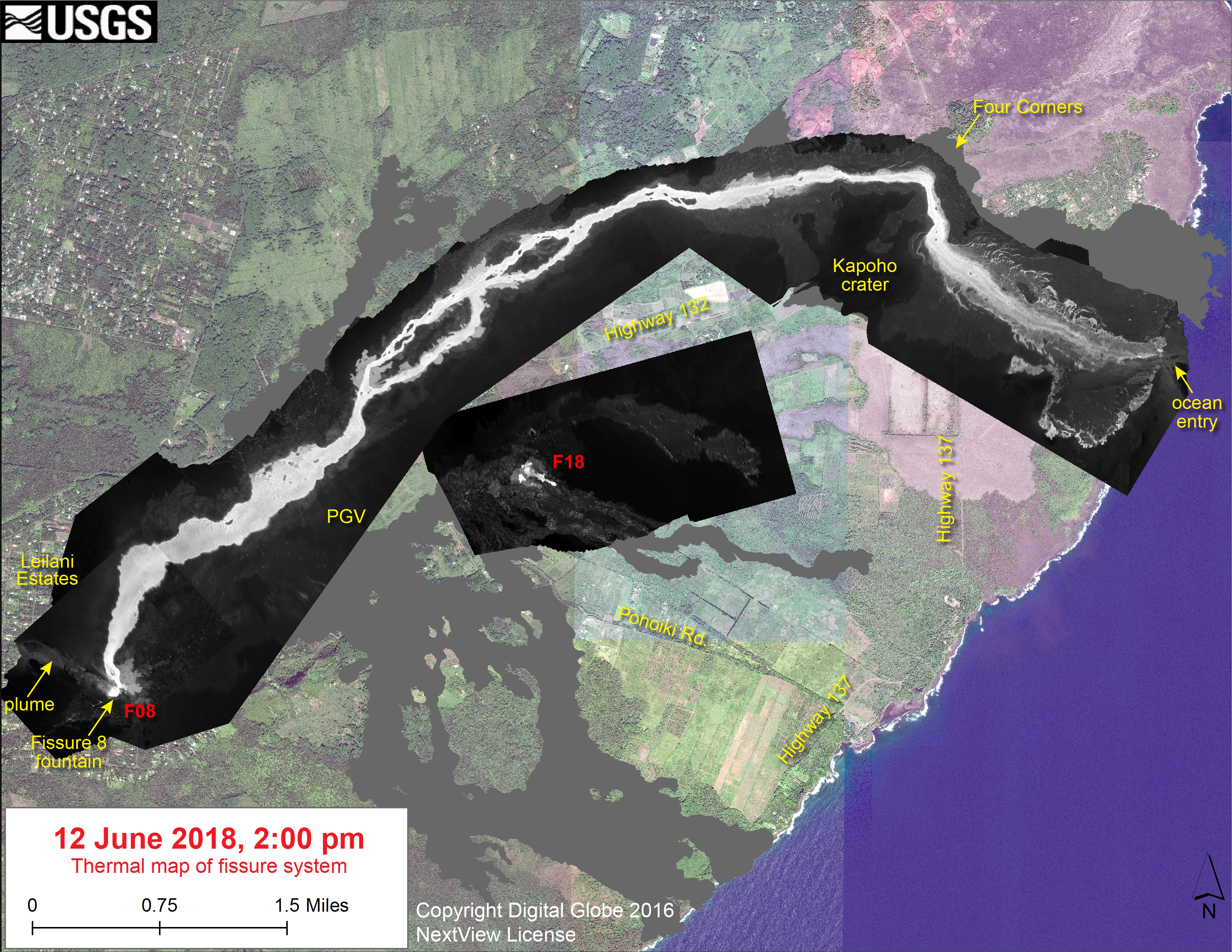
This thermal map shows the fissure system and lava flows as of 2 pm on Tuesday, June 12. The fountain at Fissure 8 remains active, with the lava flow entering the ocean at Kapoho. Very small, weak lava flows have been active recently near the Fissure 18 area. The black and white area is the extent of the thermal map. Temperature in the thermal image is displayed as gray-scale values, with the brightest pixels indicating the hottest areas. The thermal map was constructed by stitching many overlapping oblique thermal images collected by a handheld thermal camera during a helicopter overflight of the flow field. The base is a copyrighted color satellite image (used with permission) provided by Digital Globe
.
Kīlauea Volcano Summit
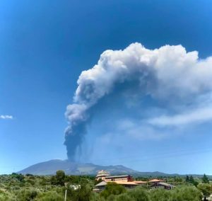
At 3:39 AM HST, another small explosion occurred at Kīlauea’s summit, producing a plume which rose 7,000 to 8,000 ft above sea level and drifted with the trade winds to the southwest. Inward slumping of the rim and walls of Halema`uma`u continues in response to ongoing subsidence at the summit and large rockfalls from the crater walls were detected overnight.
Wednesday, June 13, 2018, 3:57 PM HST (Thursday, June 14, 2018, 01:57 UTC)
Kīlauea Volcano Lower East Rift Zone
The eruption of lava continues from the lower East Rift Zone (LERZ) in Leilani Estates.
Lava fountain heights of 30-40 m (100-130 ft) were observed at Fissure 8 during the day. Lava spreading northeast from the fissure flowed through the well-established channel to the ocean at Kapoho, with rare small overflows of the channel levees. A laze plume at the ocean entry was blown onshore this afternoon, and areas of upwelling offshore were present throughout the day. The limited activity at fissures 16 and 18 of the past several days (spattering and small flows) continues this afternoon.
Kīlauea Volcano Summit
Following this mornings small explosion at Kīlauea’s summit, earthquake activity returned to low levels for much of the day, but began a steady increase by this late afternoon. Inward slumping of the rim and walls of Halema`uma`u continues in response to ongoing subsidence at the summit.
Source : HVO
Galeras , Colombia :
Subject: Galeras Volcano Extraordinary Activity Bulletin
The level of activity of the volcano continues at the level:
YELLOW LEVEL ■ (III): CHANGES IN THE CONDUCT OF VOLCANIC ACTIVITY.
Following the activity of the GALERAS volcano, the COLOMBIAN GEOLOGICAL SERVICE informs that:
During the last hours, it has been recorded, as seismic swarm, several earthquakes related to the fracturing of cortical material called Volcano-Tectonique highlighting those that took place today at 4:35, 04:36. and 04:46, which were located to the east side of the Galeras Volcano Complex, at an approximate distance of 4.5 to 6.0 km from the crater of the volcano, with mean depths of less than 6 km (from the top, reference of 4200 m) and which respectively reached amplitudes of M4.5, M4.3 and M3.4 on the Richter scale. These earthquakes were felt by the inhabitants of the zone of influence of the volcano and According to preliminary reports from the Disaster Risk Management Office of the Municipality of Pasto, landslides and rocks were seismically generated on the Pasto road that leads to Nariño Commune. They spawned some assignments in houses especially in the buildings of the northern sector of the city of San Juan de Pasto.

This seismicity occurs in an epicentral region similar to that reported with the earthquakes that occurred on May 29 and June 2, 2018. After the major earthquakes mentioned, there were about 90 aftershocks of lesser magnitude, up to 2, 8 on the Richter scale. The other geophysical and geochemical type parameters recorded from the permanent monitoring of Galeras volcano activity remain stable at low levels.
Subject: Galeras Volcano Extraordinary Activity Bulletin
The level of activity of the volcano continues at the level:
YELLOW LEVEL ■ (III): CHANGES IN THE CONDUCT OF VOLCANIC ACTIVITY.
Following the activity of the GALERAS volcano, the COLOMBIAN GEOLOGICAL SERVICE informs that:
In addition to the information published by the Colombian Geological Survey, the following aspects are highlighted:
– After the Volcano-Tectonic earthquake that occurred this morning at 4:35, from Magnitude M4.5 until the time of this bulletin, a total of nearly 310 earthquakes were recorded, of which 9 (3%) were have been reported as felt by the inhabitants of the Galeras Volcanic Complex’s influence zone.
– This seismicity is located in an area north-east of the Galeras volcano at distances between 1 and 8 km and depths between 1.2 and 7.5 km from the summit (reference level 4200 m).
– The seismicity that has been recorded since the end of May and especially since dawn today, is located in an active zone where tectonic geological faults coexist with the structure of the volcanic complex of Galeras, and therefore this type of earthquakes is classified as Volcano-Tectonics.
– It is recalled that the other parameters of geophysical and geochemical monitoring of the Galeras volcano have so far not shown any significant change and has therefore been maintained the level of activity in yellow or III, as for about 7 years.
– Through social networks, audios and texts that are not true are circulating, seeking to generate panic and confusion in communities. Please, please only pay attention to information from official sources
The COLOMBIAN GEOLOGICAL SERVICE remains attentive to the evolution of the volcanic phenomenon and will continue to inform in a timely manner of the observed changes.
Source : IGP
Ambae , Vanuatu :
15.389°S, 167.835°E
Elevation 1496 m
The Vanuatu Meteorology and Geo-hazards Department reported that activity at Ambae’s Lake Voui decreased in May, and by 7 June had ceased; the Alert Level was lowered to 2 (on a scale of 0-5) and a 2-km-radius exclusion zone was emplaced. Steam and volcanic gas emissions continued, and were reportedly smelled by local residents near the volcano.
Ambae volcano is in the major unrest state. The Volcanic Alert Level is lowered to Level 2 .
Ambae volcano activity becomes stable. The current volcanic activity is consistent with Volcanic Alert Level 2. The Danger Zone for life safety is now limited at 2 km radius from the active vent and areas located in the Yellow Zone (See Map below).
Observations in May 2018 confirm that the eruptive activity occurred in March until April has dropped. There is no explosions and volcanic cloud emitted are white color, means only steam. A small scale eruption in Lake Voui has ceased.
The presence of ash that has fallen on Ambae during the last eruption will continue to change the behavior of streams and creeks when it rains. The creeks and streams can produce floods and carry a lot more debris (sands, gravel and boulders). The flow path of streams and creeks could change due to the flood debris. Landslide may occur at some areas during heavy rain fall.
Source: GVP , Département de météorologie et de géo-risques du Vanuatu.
Santiaguito , Guatemala :
SPECIAL BULLETIN VULCANOLOGICAL BULLETIN # 67-2018 Guatemala June 13, 2018, 14:45 (Local time)
Moderate lahar in Rio NIMÁ I, tributary of RÍO SAMALÁ
Attraction type: Peléan
Morphology: Complex of dacitic domes
Geographical location: 14 ° 44 ’33 ˝ Latitude N; 91 ° 34’13˝ Longitude W.
Altitude: 2,500msnm.
As severe weather conditions continue in the Santiaguito volcano area at 14:15, the Santiaguito OVSAN Observatory and the Stg3 seismic station recorded the descent of a moderate lahar into the Nima River, a tributary of Samalá River. This lahar has dimensions ~ 18 meters wide and 1.2 meters high, dragging blocks of volcanic material up to 2 meters in diameter. Its frontal part pulls tree trunks, shrubs and sediments from the walls of the canals in which it advances.
We do not exclude the possibility that it will become strong due to the number of tributaries added to it on its way to the Samalá River.
Source : Insivumeh
Sabancaya , Peru :
The number of explosions did not show any significant changes, recording an average of 24 EXP / day. The events associated with fluid movements (long period type) and activity associated with ash and gas emissions (Tremor type) continue to predominate. The earthquakes associated with the rise of the magma (type Hybrids) remain very weak in number and energy.
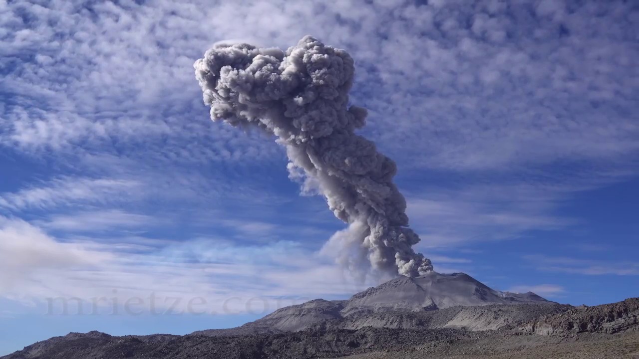
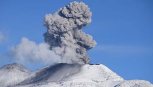
The eruptive columns of gas and ash reached a maximum height of 1300 m above the crater.
The dispersion of these materials occurred within a radius of about 20 km, mainly in the South and Southeast directions.
The volcanic gas (SO2) flow recorded on June 5 had a maximum value of 5600 tons / day, a value considered large.
The SBSE GPS station has not recorded any significant changes in volcanic deformation.
No thermal anomalies were recorded according to the MIROVA system.
In general, eruptive activity maintains moderate levels. No significant changes are expected in the following days.
Source : IGP
Photo : M Rietze.