May 25 , 2018.
Pu’u ‘Ō’ō / Kilauea , Hawai:
Wednesday, May 23, 2018, 10:46 PM HST (Thursday, May 24, 2018, 08:46 UTC)
19°25’16 » N 155°17’13 » W,
Summit Elevation 4091 ft (1247 m)
Current Volcano Alert Level: WARNING
Current Aviation Color Code: RED
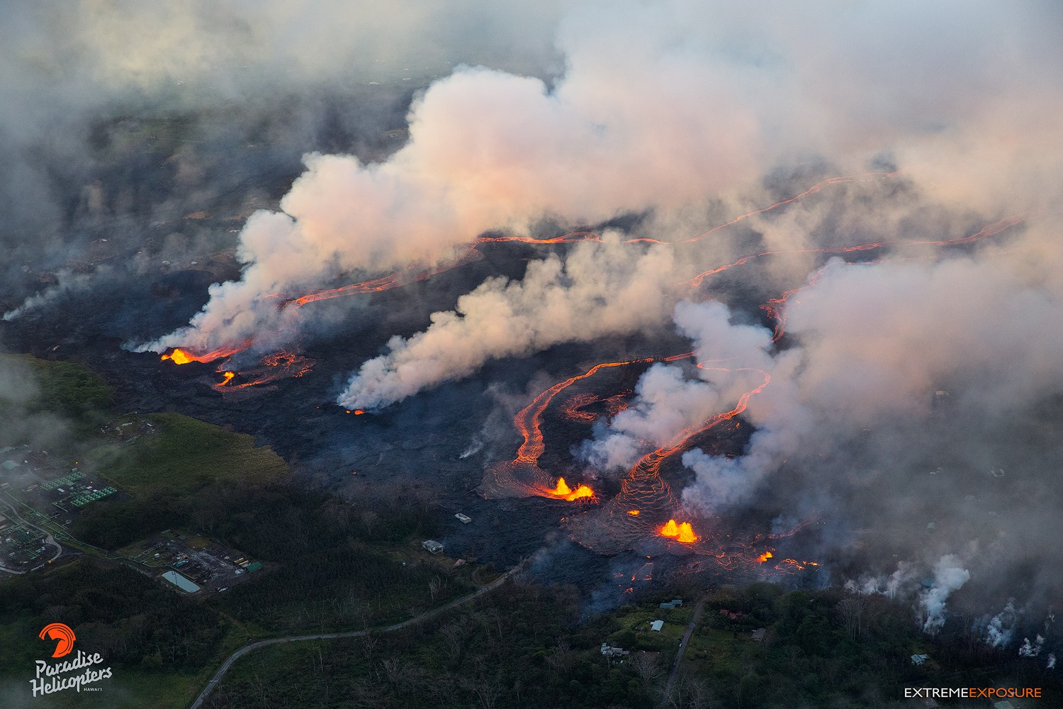
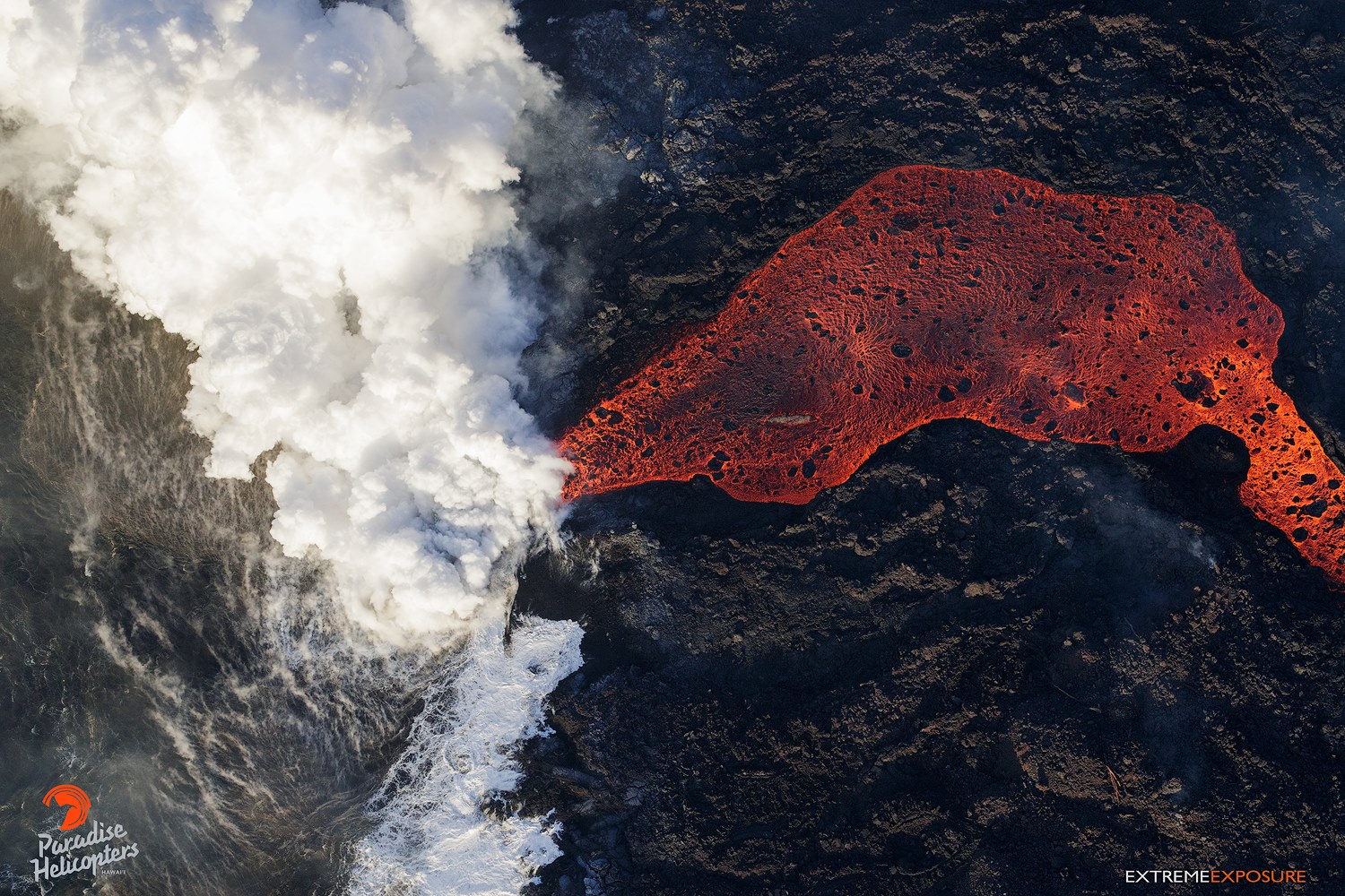
Kīlauea Volcano Lower East Rift Zone
Eruption of lava and ground cracking continues in the area of Leilani Estates and Lanipuna Gardens subdivision.
The middle portion of the fissure system continues to produce the most robust eruptive activity in the Lower East Rift Zone. The fountains from Fissure 22 feed a single lava channel that reaches the coast just north of MacKenzie State Park. The actual point of entry has continued shifting to the west. Fountains erupted from Fissures 5, 6, 13, and 19 continued to feed a lava flow advancing to the south along the west side of Fissure 22 flows that reached the ocean late this afternoon.There are now two ocean entry points that produce occasional small explosions.
May 23, 2018 Fissures 5 & 6 Going Off from Mick Kalber on Vimeo.
Volcanic gas emissions remain very high from the fissure eruptions.
Additional ground cracking and outbreaks of lava in the area of the active fissures are possible. Residents downslope of the region of fissures should heed all Hawaii County Civil Defense messages and warnings.
Magma continues to be supplied to the lower East Rift Zone. Elevated earthquake activity continues, but earthquake locations have not moved farther downrift in the past couple of days. Only a few earthquakes located yesterday in the rift zone.
USGS/HVO continues to monitor the lower East Rift Zone activity 24/7 in coordination with Hawaii County Civil Defense. Geologists are onsite to track fissure activity and the advance of lava flows.
Kīlauea Volcano Summit
Small ash emissions from the Overlook crater have occurred frequently through the day. Moderate trade winds were blowing to the southwest today and ashfall may be noticed in downwind locations. A small explosion from overlook crater at 06:44 pm produced an ash cloud that reached 7000 feet above sea level as determined by the National Weather Service radar. The cloud did not contain much ash and dispersed quickly.
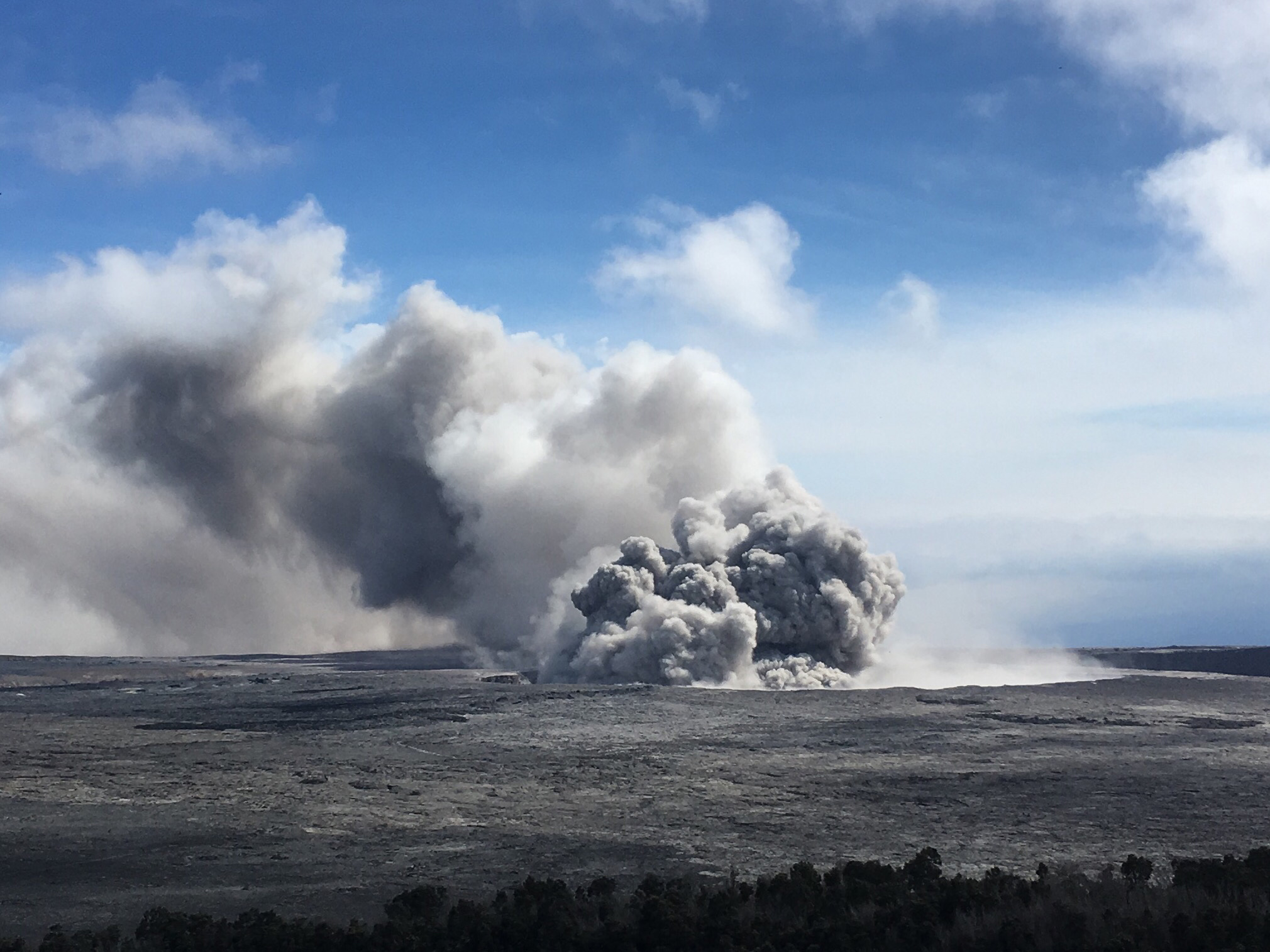
A pulse of ash rises from Halema‘uma‘u as part of semi-continuous emissions at Kīlauea’s summit today. Ash can be seen falling from the plume as it is blown downwind in this image, taken around 3:28 p.m. HST. USGS photo by I. Johanson.
Earthquakes in the summit area continue at a moderate rate, as does deflation of the summit region. At 05:12 this evening the summit area was shaken by a shallow M3.5 earthquake approximately 0.7 miles below the caldera floor that was felt by people in the area. Many smaller earthquakes followed for the next 1.5 hours. The sequence of earthquakes stopped when an ash explosion occurred at 06:44 pm. The earthquakes and ash explosions are occurring as the summit area subsides and adjusts to the withdrawal of magma from the summit.
Additional explosive events that could produce minor amounts of ashfall downwind are possible at any time. Volcanic gas emissions at the summit remain high.
Thursday, May 24, 2018, 8:12 AM HST (Thursday, May 24, 2018, 18:12 UTC)
Kīlauea Volcano Lower East Rift Zone
Eruption of lava continues in the area of Leilani Estates and Lanipuna Gardens subdivision.
The middle portion of the fissure system (centered on Pohoiki Rd.) continues to produce the most robust eruptive activity in the Lower East Rift Zone. Overnight, field crews observed that fissure areas 2, 7, 8 and 3, 14, 21 (between Luana and Kaupili St. in Leilani Estates) reactivated and are spattering. Intermittent signals recorded on sensors closest to the two ocean entries suggest they remain active; .
Volcanic gas emissions remain very high from the fissure eruptions.
Kīlauea Volcano Summit
Small ash emissions from the Overlook crater continued overnight. Moderate trade winds were blowing to the southwest and light ashfall likely occurred in downwind locations. Ash emissions reached 6000′ during the most energetic explosions above sea level as observed in the National Weather Service radar, but dispersed quickly.
Earthquakes in the summit area continue at a moderate rate, as does deflation of the summit region. The earthquakes and ash explosions are occurring as the summit area subsides and adjusts to the withdrawal of magma from the summit.
Additional explosive events that could produce minor amounts of ashfall downwind are possible at any time. Volcanic gas emissions at the summit remain high.
Thursday, May 24, 2018, 5:12 PM HST (Friday, May 25, 2018, 03:12 UTC)
LOWER EAST RIFT ZONE
Moderate-level eruption of lava continues from multiple points along the active fissure system. Residents in lower Puna should remain informed and heed Hawaii County Civil Defense closures, warnings, and messages (http://www.hawaiicounty.gov/active-alerts)
Fissure 22 continues to erupt lava that is flowing southeast to the coast where lava is entering the ocean. Fairly tall fountains at Fissures 6 and 13 feed lava into a channel that reached the coast yesterday making a second ocean entry.
Fissure 7 and 21 are feeding a pahoehoe flow that has advanced eastward covering most of the area bounded by Leilani Blvd, Mohala St., and and the fissure line.
Fissure 17 continues weak spattering, Fissure 19 and 23 are no longer active.
HVO field crews are on site tracking the lava flows and spattering from multiple fissures as conditions allow and reporting information to Hawaii County Civil Defense.
Volcanic gas emissions have tripled as a result of the voluminous eruptions from the erupting fissures so SO2 concentrations are likely elevated to higher levels throughout the area downwind of the vents. Moderate trade winds today means that areas downwind of Kilauea gas emission sources may experience varying levels of vog.
This eruption is still evolving and additional outbreaks of lava are possible. Ground deformation has slowed and seismicity levels have decreased in the area.
Future outbreaks could occur both uprift (southwest) and downrift (northeast) of the existing fissures, or, existing fissures can be reactivated. Communities downslope of the fissure system could be at risk from lava inundation. Activity can change rapidly.
KILAUEA SUMMIT
Multiple small eruptions of ash occurred over the past day, all ejecting ash to under 10,000 ft above sea level. One of the largest occurred about 10:30 this morning. Additional explosions are possible at any time.
Seismic levels, which abruptly decreased after the recent explosive eruptions, are again slowly increasing.
At this time, based on HVO web cameras, a robust plume of gas and steam is billowing out of the Overlook vent and drifting generally southwest.
At any time, activity may again become more explosive, increasing the intensity of ash production and producing ballistic projectiles very near the vent. Communities downwind should be prepared for ashfall as long as this activity continues.
Source : HVO
Videos : USGS , Mick Kalber , Big Island Vidéo News .
Photos : USGS, Paradise Helicopter / Bruce Omori .
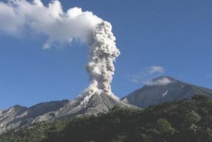
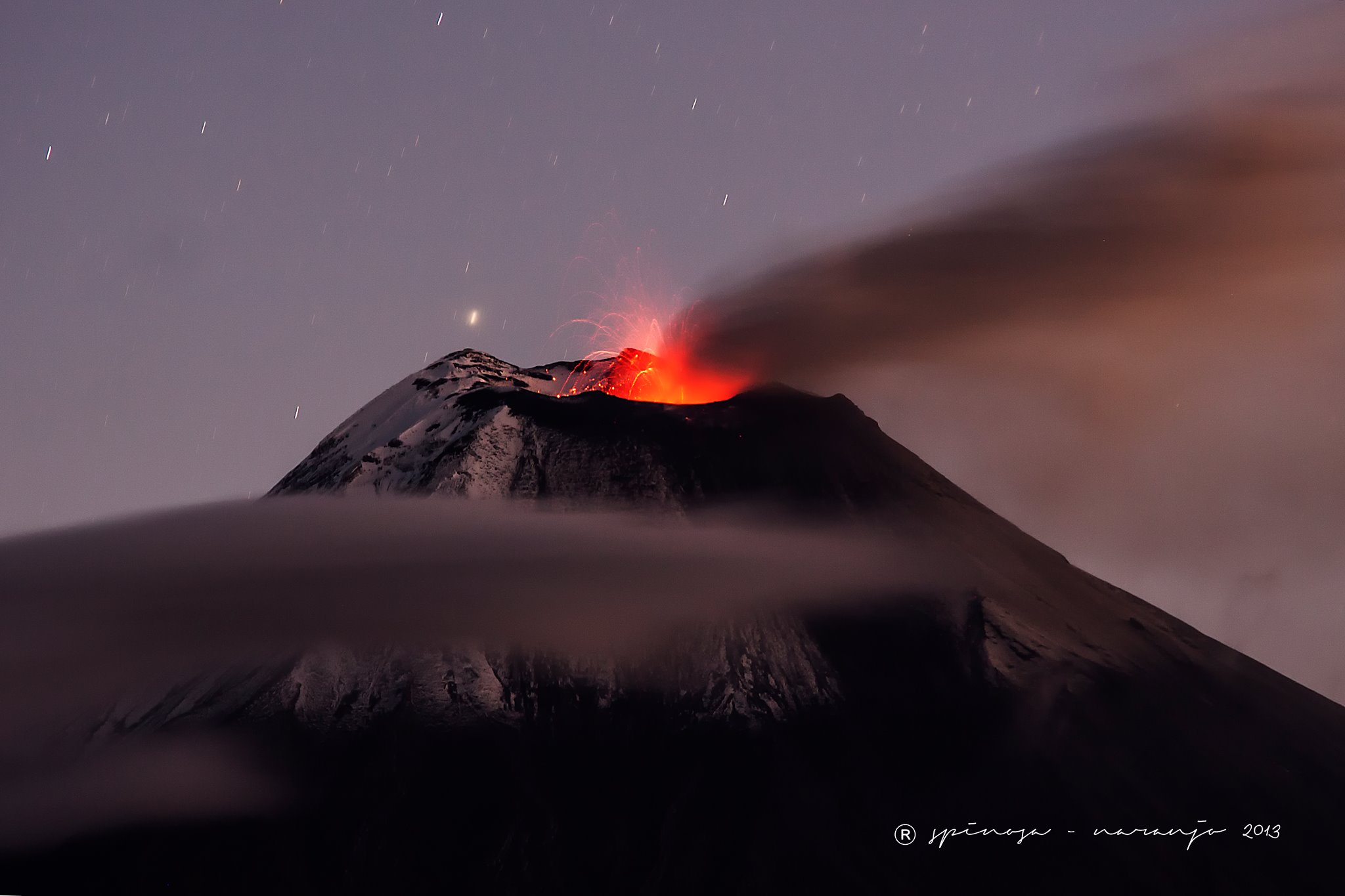
Reventador , Ecuador :
The Institute of Geophysics of the National Polytechnic School (IG) announced today, Thursday, May 24, 2018, that a lava flow was observed on the northeast flank of the Reventador volcano and the strong eruptive activity of the volcano persists. The GI has warned that the upper part of the Reventador volcano is in the clouds, so « through a thermal camera, it was possible to observe the lava flow on the northeast flank ». The activity of the volcano was reported in the report 144. Mario Ruiz, of the Institute of Geophysics of the National Polytechnic School, explained that the flow of lava did not leave the caldera and that there are small explosions that fall on the lower part of the cone of the volcano. The activity remains high.
On May 19, it was possible to visualize columns of steam and ash more than 1000 meters above the crater level. The eruptive activity began in November 2002. The volcano is located about 90 kilometers east of Quito, on a spur of the eastern branch of the Andes that gets lost with the appearance of the Amazon basin. It has a height of 3,560 meters and is characterized by the generation of explosions, emissions of gas and ash, lava flows and lahars.
WEDNESDAY, MAY 23, 2018
The Institute of Geophysics of the École Polytechnique reports that:
High eruptive activity is maintained. The area remained cloudy, however, thanks to our thermal camera, it was possible to observe the lava flow on the North-East flank. Light rains were reported at that time.
The Institute of Geophysics of the Ecole Polytechnique is attentive to the activity of the volcano and will inform any changes that may occur.
Source : ElComercio.com , INSTITUTO GEOFÍSICO ESCUELA POLITECNICA NACIONAL
Photo : José Luis Espinosa Naranjo.
Dukono , Indonesia :
VOLCANO OBSERVATORY NOTICE FOR AVIATION – VONA.
Issued: May 24 , 2018.
Volcano: Dukono (268010)
Current Aviation Colour Code: ORANGE
Previous Aviation Colour Code: orange
Source: Dukono Volcano Observatory
Notice Number: 2018DUK80
Volcano Location::N 01 deg 41 min 35 sec E 127 deg 53 min 38 sec
Area: North Maluku, Indonesia
Summit Elevation: 3933 FT (1229 M)
Volcanic Activity Summary:
Eruption with volcanic ash cloud at 21h50 UTC (06h50 local).
Volcanic Cloud Height:
Best estimate of ash-cloud top is around 4893 FT (1529 M) above sea level, may be higher than what can be observed clearly. Source of height data: ground observer.
Other Volcanic Cloud Information:
Ash cloud moving to West.
Remarks:
Eruption and ash emission is continuing.
Source : Magma
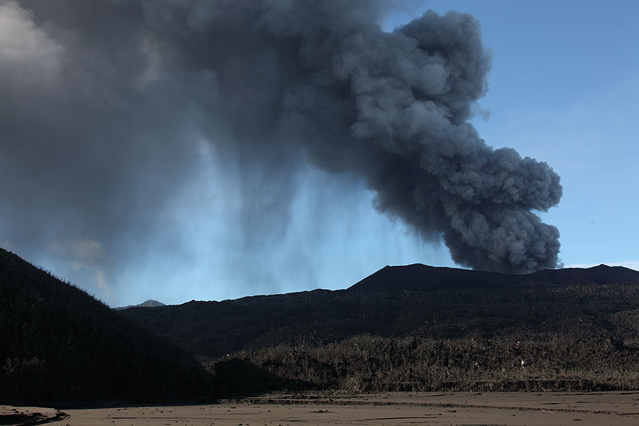
Piton de la Fournaise , La Réunion :
Activity Bulletin from Thursday, May 24, 2018 at 3:00 pm (local time)
The eruption started on April 27, 2018 at 23:50 local time continues. The intensity of the volcanic tremor (indicator of surface eruptive intensity) has stabilized at the relatively low level recorded yesterday.

– Improved weather conditions on the top of the Piton de la Fournaise allowed the observation of the eruptive site by the cameras (Figure 2) and to confirm that the main vent closed, and that the flows are carried out mostly in the lava tunnel.
– Surface discharges could not be estimated from satellite data in the last 24 hours due to cloud cover on the volcano.
– The inflation of the building seems to have stopped.
– No volcano-tectonic earthquake has been recorded during the last 24 hours under the Piton de la Fournaise building.
Alert level: Alert 2-2 – Eruption in the Enclos .
Source : OVPF
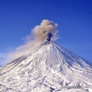
Bezymianny , Kamchatka :
55.97 N, 160.6 E;
Elevation 9453 ft (2882 m)
Aviation Colour Code is YELLOW
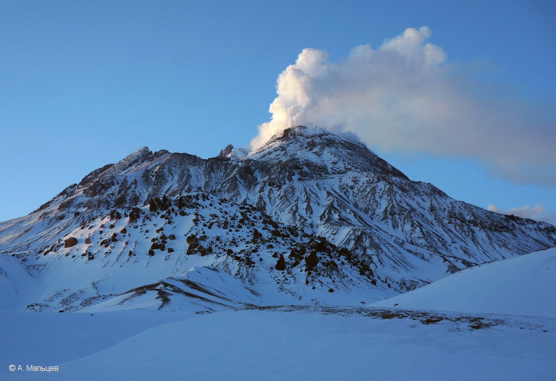
Fumarole activity of Bezymianny volcano on 13 April, 2018.
A moderate gas-steam activity of the volcano continues. Ongoing activity could affect low-flying aircraft.
A moderate gas-steam activity of the volcano continues. Satellite data by KVERT showed a thermal anomaly over the volcano on 19-20, 23-24 May, the volcano was obscured by clouds in the other days of week.
Source : Kvert .
Photo : A. Maltsev , 13/4/2018