May 18 , 2018.
Pu’u ‘Ō’ō / Kilauea , Hawai :
May 17, 2018 5:00 am, Civil Defense of Hawaii County, an explosive eruption occurred on Kilauea:
A message from HAWAII COUNTY
This is a civil defense message for May 17 at 5:00. The Hawaiian Volcano Observatory reports that an explosive eruption took place at the top of Kilauea. The resulting ash plume will cover the surrounding area. The wind will carry the plume towards the Southeast. You should take shelter if you are on the way to the plume of ashes. Driving conditions can be dangerous. If you drive, stop the road and wait for visibility to improve.
This email was sent to you by the COUNTY OF HAWAII.

HVO/USGS Volcanic Activity Notice
Current Volcano Alert Level: WARNING
Current Aviation Color Code: RED
Issued: Thursday, May 17, 2018, 6:33 AM HST
Source: Hawaiian Volcano Observatory
Notice Number:
Location: N 19 deg 25 min W 155 deg 17 min
Elevation: 4091 ft (1247 m)
Area: Hawaii
Volcanic Activity Summary:
At about 0415 this morning, an explosion from the Overlook vent within Halemaumau crater at Kilauea Volcano’s summit produced a volcanic cloud that reaches as high as 30,000 ft asl and drifted northeast. Continued emissions from the crater are reaching as high as 12,000 ft asl.
At any time, activity may again become more explosive, increasing the intensity of ash production and producing ballistic projectiles near the vent.
Recent Observations:
[Volcanic cloud height] up to 30,000 ft asl
[Other volcanic cloud information] Drifting generally northeast

Hazard Analysis:
[Ash cloud] The ashcloud is drifting downwind to the northeast.
[Ashfall] Ashfall has been reported in Volcanoes National Park, and may occur further downwind.
[Other hazards] Ballistic projectiles may be produced should steam-driven explosions occur. Impacts will be limited to an area around Halemaumau.
[Volcanic gas] Vog or volcanic air pollution produced by volcanic gas has been reported in Pahala.
Thursday, May 17, 2018, 10:40 AM HST (Thursday, May 17, 2018, 20:40 UTC)
LOWER EAST RIFT ZONE
Low-level eruption of lava continues from multiple points along the northeast end of the active fissure system. Residents in lower Puna should remain informed and heed Hawaii County Civil Defense closures, warnings, and messages (http://www.hawaiicounty.gov/active-alerts)
Spattering continues from Fissure 17 but the lava flow erupted from the fissure has not advanced significantly over the past day.
HVO field crews are on site tracking the lava flow and spattering from multiple fissures as conditions allow and reporting information to Hawaii County Civil Defense.

Aerial view of ground cracks on Pohoiki Road during an overflight of the eruptive fissure area at about 7 a.m. HST. Cracks continued to open and widen, some with horizontal and vertical offsets, in the area during the past 24 hours. These cracks are caused by the underlying intrusion of magma into the lower East Rift Zone.
Volcanic gas emissions remain elevated throughout the area downwind of the vents. Weak winds today means that other areas of Hawaii Island may experience varying levels of vog.
This eruption is still evolving and additional outbreaks of lava are possible. Ground deformation continues and seismicity remains elevated in the area.
Future outbreaks could occur both uprift (southwest) and downrift (northeast) of the existing fissures, or, existing fissures can be reactivated. Communities downslope of these fissures could be at risk from lava inundation. Activity can change rapidly.
Conditions around the erupting fissures can change very quickly. Residents in lower Puna should remain informed and heed Hawaii County Civil Defense closures, warnings, and messages (http://www.hawaiicounty.gov/active-alerts).
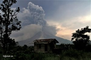
KILAUEA SUMMIT
Explosive eruption of ash this morning. Additional explosions possible at any time.
Just after 4 am this morning, an explosion or series of explosions from the Overlook vent within Halemaumau crater at Kilauea Volcano’s summit produced a volcanic cloud that reached as high as 30,000 ft asl based on NWS radar information. The cloud drifted generally northeast and traces of ash fell with rain in the Volcano Golf Course, Volcano Village, and other areas immediately around the Kilauea summit.
At this time, based on HVO web cameras, a robust plume of gas, steam, and some ash is billowing out of the Overlook vent and drifting generally southwest.
At any time, activity may again become more explosive, increasing the intensity of ash production and producing ballistic projectiles very near the vent. Communities downwind should be prepared for ashfall as long as this activity continues.
Thursday, May 17, 2018, 4:54 PM HST (Friday, May 18, 2018, 02:54 UTC)
Kīlauea Volcano Summit
After the explosive eruption early this morning seismic levels have been gradually increasing, but as of this report no additional explosions have occurred.
No earthquakes greater than magnitude 3.5 have occurred in the past day.
Volcanic gas emissions at the summit remain high.
Kīlauea Lower East Rift Zone
This afternoon, fissure 17 is still actively spattering but the flow is nearly stalled. In addition, fissures 18, 19, and 20 have reactivated and a new fissure (21) has opened between fissures 7 and 3. An area 50-100 yards wide, parallel to and north of the line of fissures between Highway 130 and Lanipuna Gardens, has dropped slightly. This long depression is currently being filled by pahoehoe lava flows from fissures 20 and 21.
Volcanic gas emissions remain elevated throughout the area downwind of the fissures.

At 3:00 p.m. HST, aerial view of a new erupting fissure (21, located between fissure 3 and 7) and lava flow in Leilani Estates. This view is toward the west. HVO geologists will track the changing activity through the night.
Magma continues to be supplied to the lower East Rift Zone as indicated by the continued northwest displacement of a GPS monitoring station. Elevated earthquake activity continues, but earthquake locations have not moved farther downrift in the past couple of days.
USGS/HVO continues to monitor the lower East Rift Zone activity 24/7 in coordination with Hawaii County Civil Defense, with geologists onsite to track ongoing and new fissure activity and the advance of lava flows.
Source : COUNTY OF HAWAII , HVO
Photos : HVO, Andrew Hara .
Vidéo : Big Island Video news
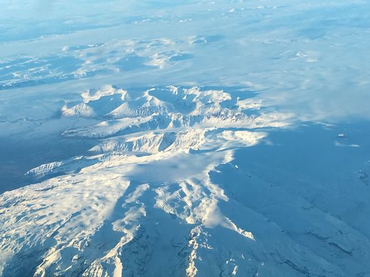
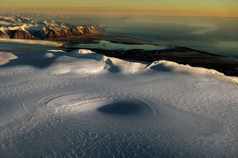
Öræfajökull , Iceland :
The IMO and The Icelandic Civile Protection Agency reassess the status for Öræfajökull
Localized hazards still possible. The volcano poses no imminent hazard to aviation.
It is close to nine months since an unrest in Öræfajökull was detected. The unrest was apparent from elevated seismicity, the development of a depression in the ice-surface (cauldron) within the caldera, and the presence of geothermal gases from a glacial river. At this time, the geothermal activity beneath Öræfajökull was assessed to be high relative to previous decades.
As that behaviour was above known background conditions, it could potentially indicate increased risk of eruptive activity that could affect air traffic. Consequently, the Icelandic Meteorological Office raised the Aviation Color Code for Öræfajökull from Green to Yellow. At the same time, the Icelandic Civil Protection and Emergency Management raised their alert level to Uncertainty phase.
Since the unrest in September 2017, the level of monitoring around the volcano has increased significantly by the addition of new monitoring equipment. This increased capability means that any future unrest can be followed more closely, hopefully leading to an early warning of a potential eruption.
The level of earthquake activity at Öræfajökull has been stable for the last months, with signs that the earthquakes are becoming smaller with time. Hydrological and geochemical measurements show stable values. Measurements in late March indicate that the geothermal heat output beneath the cauldron has diminished significantly from what is was when the cauldron formed. There is a possible small, ongoing inflation signal in Öræfajökull, however there are no signs of an imminent eruption.
The uncertainty phase declared by the Icelandic Civil Protection and Emergency Management remains in force
Considering the information above, it is assessed that Öræfajökull volcano is currently not posing an imminent hazard to aviation. Hence, the Aviation Color Code is downgraded from Yellow to Green.
However, given the recent unrest at Öræfajökull, visitors to the area should be aware that localized hazards are still possible. These hazards include unexpected glacial flooding, gas pollution and landslides that could occur without warning. Note that the uncertainty phase declared by the Icelandic Civil Protection and Emergency Management remains in force.
The Icelandic Meteorological Office monitors Öræfajökull, and all other active volcanoes in the country, 24 hours a day. Any changes will be communicated immediately via standard channels.
Source : IMO.
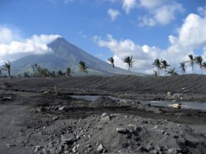
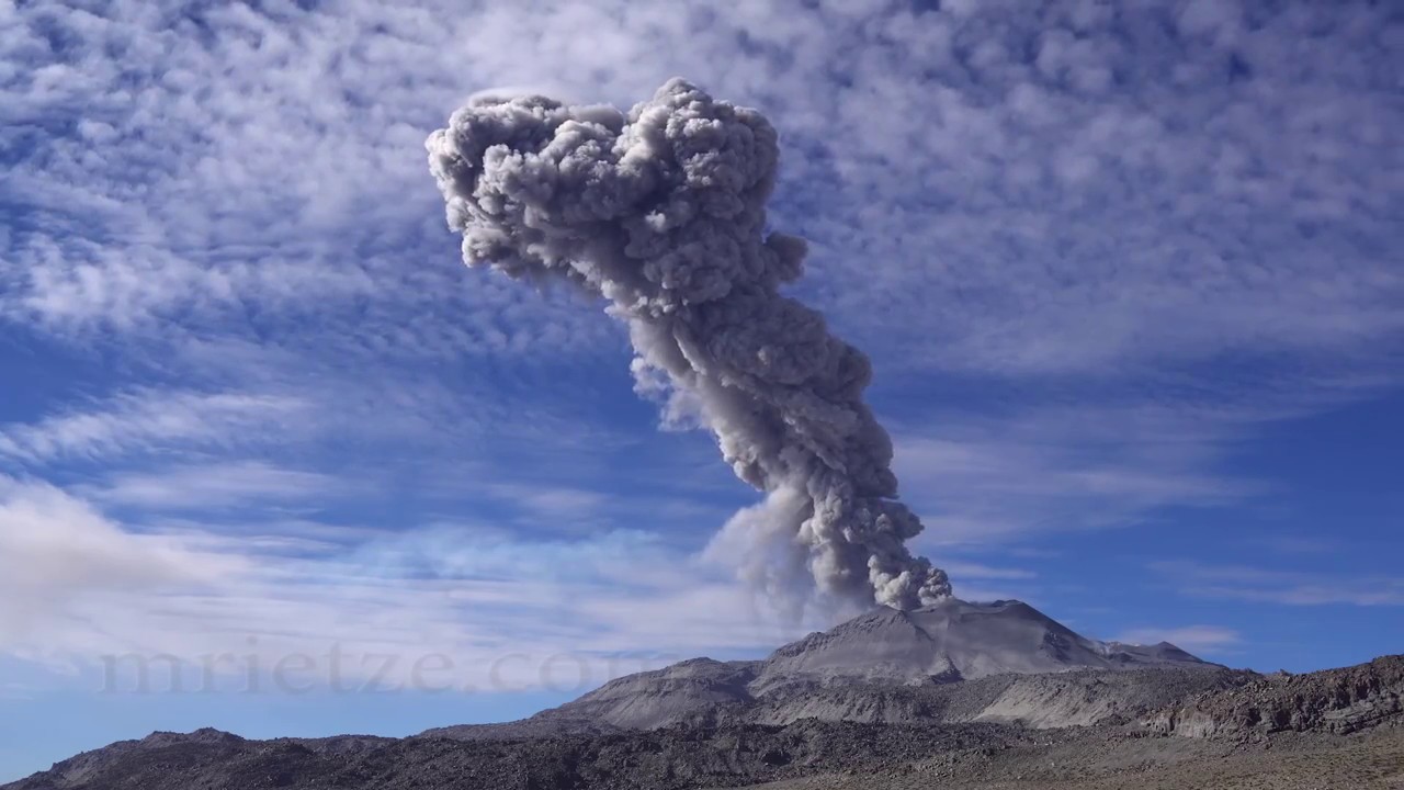
Sabancaya , Peru :
The explosive activity was maintained with an average of 27 explosions / day. Events associated with fluid movements (Long Period type) and ash emissions (Tremor type) continue to dominate. The earthquakes associated with the rise of the magma (Hybrids type) continue to be low in number and energy.
The eruptive columns of gas and ash reached a maximum height of 2000 m above the crater. The dispersion of these materials occurred within a radius of about 30 km, mainly to the north-east and south. No ash fall has been reported.
The volcanic gas (SO2) flow recorded on May 10 has a maximum value of 2432 tons / day, a value considered large.
The volcanic deformation measured at the UBGW station does not show any significant changes compared to the previous period.
Seven thermal anomalies were recorded according to the MIROVA system, with values between 1 and 18 MW VRP (Radiated Volcanic Power). In general, eruptive activity maintains moderate levels.
No significant changes are expected in the following days.
Source : IGP
Photo : Martin Rietze.
Piton de la Fournaise , La Réunion :
Activity Bulletin from Thursday, May 17, 2018 at 8:00 pm (local time):
The eruption started on April 27, 2018 at 23:50 local time continues. The intensity of the volcanic tremor (indicator of surface eruptive intensity) has remained relatively stable over the last 24 hours at values twice as high as those recorded last week.

Now the flow activity always takes place mainly in lava tunnels.
– Surface discharges could not be estimated from satellite data in the last 24 hours due to cloud cover on site.
– The inflation of the building continues.
– No volcano-tectonic earthquake has been recorded during the last 24 hours under the Piton de la Fournaise building.
Alert level: Alert 2-2 – Eruption in the Enclos.
Source : OVPF
Photo : Wilfried Prigent.
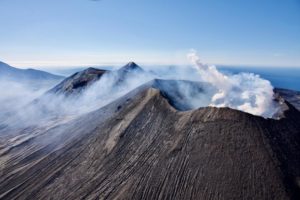
Klyuchevskoy , Kamchatka :
56.06 N, 160.64 E;
Elevation 15580 ft (4750 m)
Aviation Colour Code is ORANGE
A heightened activity of the volcano continues. Ash explosions up to 26,240 ft (8 km) a.s.l. could occur at any time. Ongoing activity could affect international and low-flying aircrafts.

A heightened activity of the volcano continues. According to visual and satellite data, a strong event occurred at 1515 UTC on 14 May: explosions sent ash up to 10.5 km a.s.l., ash clouds was staying for about 8 hours over Klyuchevskaya group of volcanoes, gradually dissipating. A hot avalanche and an incandescence of the volcanic summit at night were noted. Short gas-steam plumes containing small amount of ash sometimes were detected last week. A thermal anomaly over the volcano was noted on 13-15 May, the volcano was obscured by clouds in the other days of week.
Source : Kvert
Photo : Y. Demyanchuk , Volkstat ru , 14/5/2018